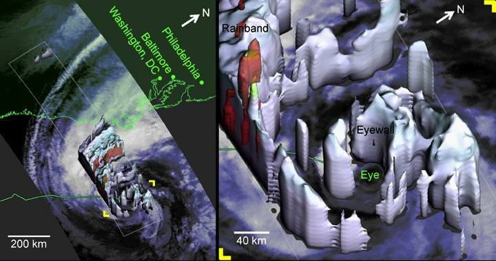
Hurricane Sandy as viewed by the TRMM Precipitation Radar at 2:20 EDT on Oct. 28, 2012. Credit: NASA
Satellite imagery and data has been invaluable in predicting the path and intensity of storms like Hurricane Sandy. Satellites like NASA’s Tropical Rainfall Measuring Mission (TRMM) can measure rainfall rates and cloud heights in tropical cyclones, and was used to create a 3-D image, above, to allow forecasters to look inside the hurricane, and predict fairly spot-on what locations would be affected the worst. There’s even a 3-D video view from the CloudSat satellite, and much more, including a stunning wind map, and this round-up from JPL of various satellite views of the storm. You can also see a slideshow of NASA satellite images and videos on the NASA Goddard Flickr site.
This exemplifies just one reason why space exploration is important, and why people are maybe now starting to realize how our failure to plan ahead and invest in weather satellites may become a problem. Without those eyes in the sky we are blind to the minute-to-minute and hour-to-hour development of storms and weather, not to mention overall study of the climate.
Below is a stunning high-speed satellite view from the GOES-14 satellite:
Focusing just on the area of the storm, the GOES-14 Super Rapid Scan Operation (SRSO) captures infrared and visible data every minute and relays that information to forecasters on the ground. This animation shows the GOES-14 SRSO for October 29, 2012 as Hurricane Sandy approached the U.S. coastline.
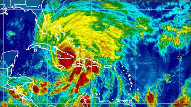
Hurricane Sandy made landfall on Cuba early Thursday Oct. 25, 2012 as strong Category 2. Credit: NOAA/National Hurricane Center
Meteorologists keeping an eye on Hurricane Sandy say the storm threatens to move up along the east coast of the United States and could mix with a wintery storm coming from the west to form a monster storm that has been informally dubbed “Frankenstorm.” The hurricane could reach the US coast by this weekend and when the two storms collide, it could continue to pound the eastern seaboard well into the week of Halloween.
Hurricane Sandy is now in the Caribbean as a Category 2 storm coastal areas from Florida to Maine will feel some effects, forecasters predict. The mix of the two storms could cause weather problems in the Washington DC area to New York city, some of the most populous areas of the US.
Satellite image of then Tropical Storm Sandy taken on October 23, 2012 as it was over the Caribbean Sea taken by the Moderate Resolution Imaging Spectroradiometer (MODIS) on NASA’s Terra satellite. NASA image courtesy Jeff Schmaltz, LANCE MODIS Rapid Response Team at NASA GSFC.
Forecasters are saying this could be a major mess, with a 90 percent chance that the East will get steady gale-force winds, heavy rain, flooding and maybe snow.
While no one can positively predict what Hurricane Sandy will do and how the two storms might mesh into one monster storm, the Washington Post’s Capital Weather Gang has outlined the possible scenarios from worst case to where the storms collide and remained parked over the region for days, to best case, where Sandy heads to the northeast sparing the East Coast from a direct hit.
We’ll post additional updated satellite views as they become available.
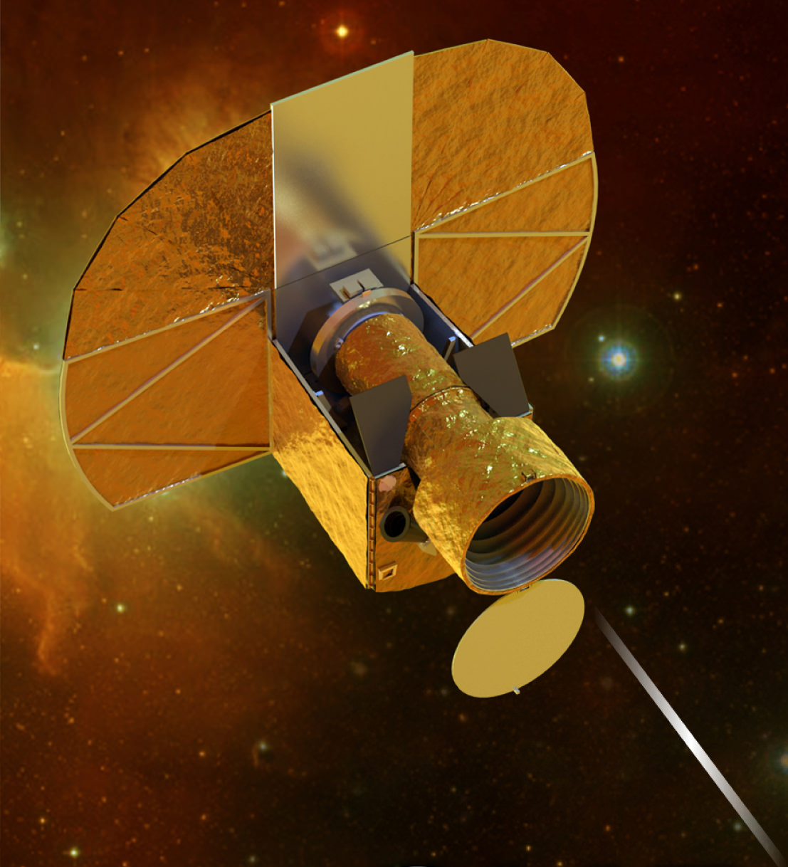
Caption: Artist impression of Cheops. Credit: University of Bern
Big isn’t always better. This is certainly true at ESA’s new Science Programme. They are looking to low cost, small scale missions that can be rapidly developed, in order to offer greater flexibility in response to new ideas from the scientific community, to complement the broader Medium- and Large-class missions. Back in March ESA called for ideas for dedicated, quick-turnaround missions focusing on key issues in space science. From 26 proposals submitted, ESA has now approved a new mission to be launched in 2017. Though small in scale this mission is big on ambition: to search for nearby habitable planets.
Cheops stands for CHaracterising ExOPlanets Satellite. It has a planned mission lifetime of 3.5 years during which it will operate in a Sun-synchronous low-Earth orbit at an altitude of 800 km, free from distortion by Earth’s atmosphere. It will target nearby, bright stars already known to have planets orbiting around them.
By high-precision monitoring of the star’s brightness, Cheops will search for signs of a ‘transit’ as a planet passes across the star’s face, it will also be able to look for smaller planets, impossible to see using ground based telescopes, around those stars.
While NASA’s Kepler mission has confirmed 77 planets so far, with another 2,321 candidate planets, not one is close enough to Earth to be analysed in detail. Cheops on the other hand, will be able to take accurate measurements of the radius of the planet. For those planets with a known mass, this will reveal the planet’s density and provide an indication of the internal structure. It will help scientists understand the formation of planets from ‘super-Earths’, a few times the mass of the Earth, up to Neptune-sized worlds. It will also identify planets with significant atmospheres which can then be analysed for signs of life by ground-based telescopes, and the next generation of space telescopes now being built, such as the ground-based European Extremely Large Telescope and the NASA/ESA/CSA James Webb Space Telescope.
“By concentrating on specific known exoplanet host stars, Cheops will enable scientists to conduct comparative studies of planets down to the mass of Earth with a precision that simply cannot be achieved from the ground,” said Professor Alvaro Giménez-Cañete, ESA Director of Science and Robotic Exploration.
The plan is for Cheops to be the first of a series of similar small missions, that can be rapidly developed at low cost to investigate new scientific ideas quickly. Cheops will be developed as a partnership between ESA and Switzerland, with a number of other ESA Member States delivering substantial contributions.
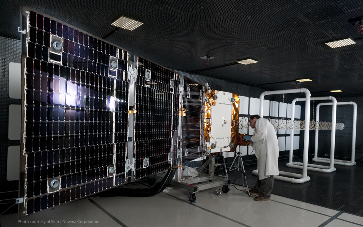
The OG2 satellite being prepared for testing. Credit: ORBCOMM
The satellite that was launched to orbit as a secondary payload by the SpaceX Falcon 9 rocket on October 7, 2012 has deorbited, falling back to Earth. The ORBCOMM OG2 satellite was a prototype communications satellite that was launched along with the Dragon capsule for the CRS-1 resupply mission to the International Space Station. The satellite was sent into the wrong orbit as a result of “a pre-imposed safety check required by NASA,” ORBCOMM said today in a press release, after the engine anomaly where one of the rocket’s nine Merlin engines, Engine 1, lost pressure suddenly and an engine shutdown command was issued. The rocket was prevented from performing a second burn for safety reasons and the satellite was left in a lower orbit than intended.
“The safety check was designed to protect the International Space Station and its crew,” the ORBCOMM press release said. “Had ORBCOMM been the primary payload on this mission, as planned for the upcoming launches, we believe the OG2 prototype would have reached the desired orbit.”
ORBCOMM had said earlier they were checking into the possibility of whether onboard propulsion could be used to boost the OG2 into a higher orbit, but obviously that was unsuccessful. They did say today, however that while the OG2 was in orbit for its much-shortened time frame, they were able to obtain engineering data and “made significant strides in testing various hardware components,” including an antenna that was deployed and basic functions of the satellite that were successfully turned on.
The company added that with the verifications they were able to achieve, they can now forge ahead and focus on completing and launching the more OG2 satellites, and they plan on using SpaceX to deliver them to orbit. But next time the satellites will be the primary mission payloads on two planned Falcon 9 launches, one in mid-2013 and another in 2014, putting them directly into their operational orbit.
“We appreciate the complexity and work that SpaceX put into this launch,” stated Marc Eisenberg, ORBCOMM’s CEO. “SpaceX has been a supportive partner, and we are highly confident in their team and technology.”
The OG2 satellite was supposed be in a final 750×750 km orbit, but the company didn’t verify the orbit it did end up in. According to Jonathan’s Space Report, OG2 was ejected at 0137 UTC into a 203×323 km orbit, instead of its planned 350×750 km insertion orbit. Another satellite tracker, T.S. Kelso said via Twitter that it was in a 318 x 194km orbit.
A call to ORBCOMM to verify the orbit and location of de-orbit wasn’t immediately returned.
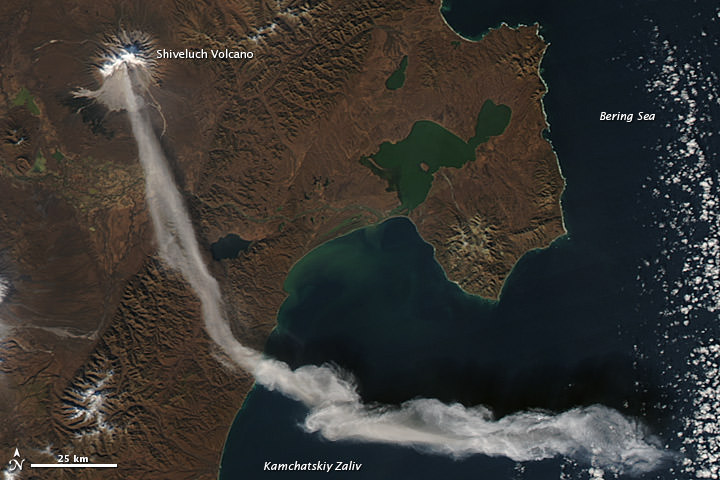
The Shiveluch volcano as seen by the Aqua satellite on October 6, 2012. Credit: NASA
It’s almost like this volcano has an on/off switch. The Shiveluch Volcano in the northern Russian peninsula of Kamchatka had been quiet, and an earlier image taken by NASA’s Terra satellite (below) at about noon local time (00:00 UTC) on October 6, 2012, showed a quiet volcano with no activity. But just two hours later when the Aqua satellite passed over the area, the volcano had erupted and sent a plume of ash over about 90 kilometers (55 miles). Later, a local volcanic emergency response team reported that the ash plume from Shiveluch reached an altitude of 3 kilometers (9,800 feet) above sea level, and had traveled some 220 kilometers (140 miles) from the volcano summit.
The same volcano seen by the Terra satellite just two hours earlier on the same day. Credit: NASA
Shiveluch is one the biggest and most active volcanoes in this region and rises 3,283 meters (10,771 feet) above sea level. NASA’s Earth Observatory website says Shiveluch is a stratovolcano composed of alternating layers of hardened lava, compacted ash, and rocks ejected by previous eruptions. It has had numerous eruptions the past 200 years, but has been active during much of its life – estimates are the volcano is 60,000 to 70,000 years old.
The beige-colored expanse of rock on the volcano’s southern slopes (visible in both images) is due to an explosive eruption that occurred in 1964. Another eruption started in 1999 and lasted for over 10 years.
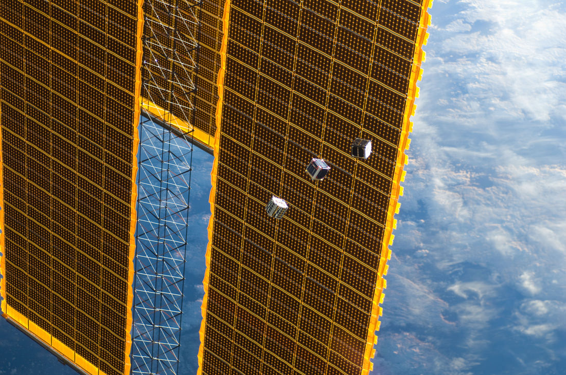
Three small CubeSats are deployed from the International Space Station on October 4, 2012. Credit: NASA
Five tiny CubeSats were deployed from the International Space Station on Thursday and astronaut Chris Hadfield called the image above “surreal” on Twitter. And rightly so, as they look like a cross between Star Wars training droids and mini Borg Cubes from Star Trek. The Cubesats measure about 10 centimeters (4 inches) on a side and each will conduct a range of scientific missions, ranging from Earth observation and photography to technology demonstrations to sending LED pulses in Morse Code (which should be visible from Earth) to test out a potential type of optical communication system.
These are low-cost satellites that could be the wave of the future to enable students and smaller companies to send equipment into space. If you’re worried about these tiny sats creating more space junk, Hadfield assured that since they are very light and in such a low orbit, the Cubesat orbits will decay within a few months.
The Rubic-cube-sized Cubesats were deployed from the new Japanese Small Satellite Orbital Deployer that was brought to the space station in July by the Japanese HTV cargo carrier.
The Japanese FITSAT-1 will investigate the potential for new kinds of optical communication by transmitting text information to the ground via pulses of light set to Morse code. The message was originally intended to be seen just in Japan, but people around the world have asked for the satellite to communicate when it overflies them, said Takushi Tanaka, professor at The Fukuoka Institute of Technology.
Observers, ideally with binoculars, will be able to see flashes of light — green in the northern hemisphere, where people will see the “front” of the satellite, and red in the southern hemisphere, where the “back” will be visible.
The message it will send is “Hi this is Niwaka Japan.” Niwaka is the satellite’s nickname and reflects a play on words in the local dialect of southwestern Japan, according to an article on Discovery Space. To see the Morse Code message, the Cubesat will be near the ISS, so find out when you can see the ISS from NASA or Heaven’s Above. Find out more about the FITSAT at this website.
The other Cubesats include NASA’s TechEdSat which carries a ham radio transmitter and was developed by a group of student interns from San Jose State University (SJSU) in California with mentoring and support from staff at NASA’s Ames Research Center.
“TechEdSat will evaluate plug-and-play technologies, like avionics designed by commercial providers, and will allow a group of very talented aerospace engineering students from San Jose State University to experience a spaceflight project from formulation through decommission of a small spacecraft,” said Ames Director S. Pete Worden.
The other Cubesats include RAIKO, which will do photography from space, We Wish, an infrared camera for environmental studies, and and the F-1 Vietnam Student CubeSat which has an on-board camera for Earth observation.
See more cool-looking images and video of the deployement below (all images credit the Expedition 32 crew from the ISS/NASA):
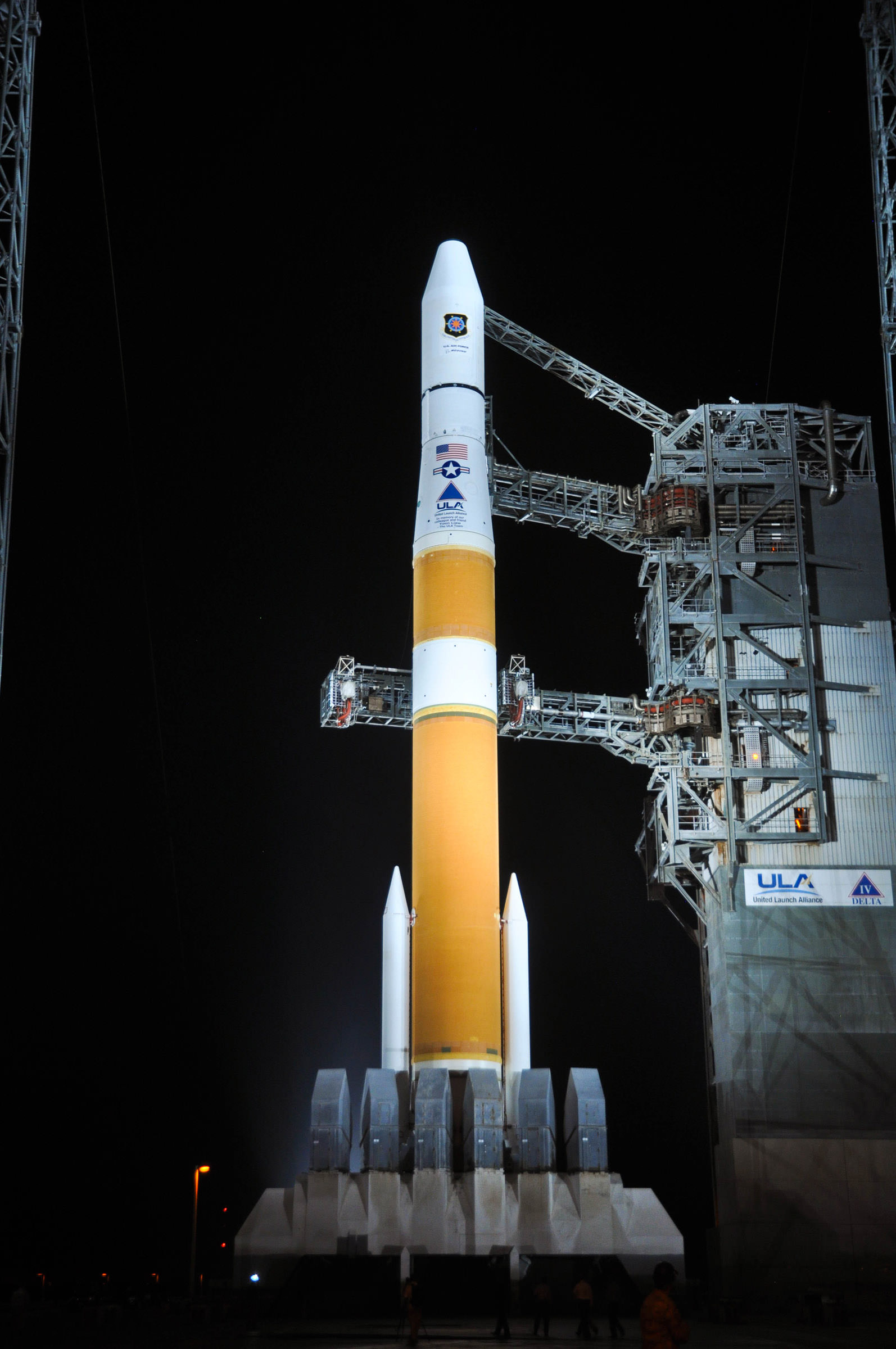
A Delta IV rocket launched from Florida today, sending a next-generation Global Positioning System satellite into orbit. The rocket lifted off at 12:10 UTC with the GPS IIF-3 satellite that will be part of the GPS system that is used by both civilians and the military. The new satellite will replace a 19-year-old navigation satellite in the global system that includes 31 operational satellites on-orbit which broadcast position, navigation and timing information to people around the world.
A United Launch Alliance Delta IV stands ready for launch at Space Launch complex 37 with the GPS IIF-3 satellite. Credit: ULA
The satellite, built by Boeing, is the third of 12 planned launches to provide improved GPS signals, featuring improved anti-jam technology, more precise atomic clocks, an upgraded civilian channel for commercial aviation and on-board processors that can be reprogrammed in flight, according to CBS News.
The new satellite should be operational by November.
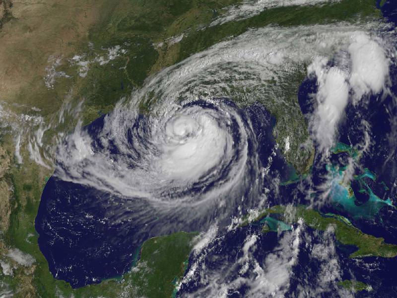
This visible image of Tropical Storm Isaac taken from NOAA’s GOES-13 satellite shows the huge extent of the storm, where the eastern-most clouds lie over the Carolinas and the western-most clouds are brushing east Texas. The image was captured on Tuesday, Aug. 28, 2012 at 10:25 a.m. EDT. Image Credit: NASA GOES Project
As expected Tropical Storm Isaac has now become a full-fledged hurricane, after being fed by the warm waters in the Gulf of Mexico. The slow moving storm is now closing in on the Louisiana-Mississippi coast and could make landfall in the region seven years to the day after Hurricane Katrina devastated the same area. It is not expected to be another Katrina, but with the slowness of the storm — about 16 km/h (10 mph) — forecasters are predicting 7-14 inches of rainfall across the coast as well as inland regions, and some places could even see 20 inches. Flooding from rainfall and storm surges are expected, according to NOAA. Satellites have been keeping an eye on the storm, and above is an image from one of the GOES satellites taken on Tuesday, August 28. Below are more satellite views.
The Proba-2 satellite’s X-Cam – Exploration Camera – acquired this image at 11:38:33 GMT on August 27, 2012. Credit: ESA
The Moderate Resolution Imaging Spectroradiometer (MODIS) on NASA’s Aqua satellite captured this natural-color image of Isaac over the Gulf of Mexico at 2:00 p.m. CDT on August 27, 2012. Credit: NASA
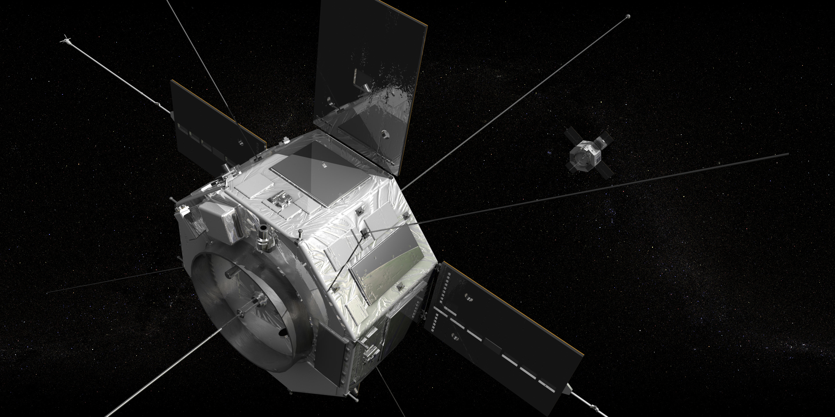
Surrounding our planet like vast invisible donuts (the ones with the hole, not the jelly-filled kind) are the Van Allen radiation belts, regions where various charged subatomic particles get trapped by Earth’s magnetic fields, forming rings of plasma. We know that the particles that make up this plasma can have nasty effects on spacecraft electronics as well as human physiology, but there’s a lot that isn’t known about the belts. Two new satellites scheduled to launch on August 23 August 24 will help change that.
“Particles from the radiation belts can penetrate into spacecraft and disrupt electronics, short circuits or upset memory on computers. The particles are also dangerous to astronauts traveling through the region. We need models to help predict hazardous events in the belts and right now we are aren’t very good at that. RBSP will help solve that problem.”
– David Sibeck, RBSP project scientist, Goddard Space Flight Center
NASA’s Radiation Belt Storm Probes (RBSP) mission will put a pair of identical satellites into eccentric orbits that take them from as low as 375 miles (603 km) to as far out as 20,000 miles (32,186 km). During their orbits the satellites will pass through both the stable inner and more variable outer Van Allen belts, one trailing the other. Along the way they’ll investigate the many particles that make up the belts and identify what sort of activity occurs in isolated locations and across larger areas.
“Definitely the biggest challenge that we face is the radiation environment that the probes are going to be flying through,” said Mission Systems Engineer Jim Stratton at APL. “Most spacecraft try to avoid the radiation belts — and we’re going to be flying right through the heart of them.”
Each 8-sided RBSP satellite is approximately 6 feet (1.8 meters) across and weighs 1,475 pounds (669 kg).
The goal is to find out where the particles in the belts originate from — do they come from the solar wind? Or Earth’s own ionosphere? — as well as to find out what powers the belts’ variations in size and gives the particles their extreme speed and energy. Increased knowledge about Earth’s radiation belts will also help in the understanding of the plasma environment that pervades the entire Universe.
Ultimately the information gathered by the RBSP mission will help in the design of future science and communications satellites as well as safer spacecraft for human explorers.
The satellites are slated to launch aboard a United Launch Alliance Atlas V rocket from Cape Canaveral Air Force Station no earlier than 4:08 a.m. EDT on August 24.
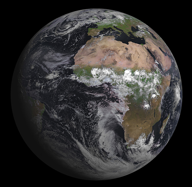
Europe’s latest geostationary weather satellite has captured its first image of Earth, and it’s a beauty! The Spinning Enhanced Visible and Infrared Imager (SEVIRI) instrument on the Meteosat Second Generation-3 (MSG-3) satellite was launched on July 5, 2012, and has since been in the commission stage. ESA says it will still be a couple of months before it is ready for operations.
SEVIRI provides enhanced weather coverage for Europe and Africa in order to improve very short range forecasts, in particular for rapidly developing thunder storms or fog. It scans Earth’s surface and atmosphere every 15 minutes in 12 different wavelengths, to track cloud development. SEVIRI can pick out features as small as a kilometer across in the visible bands, and three kilometers in the infrared.
MSG-3 is the third in a series of four satellites. In addition to its weather-watching mission and collection of climate records, MSG-3 has two secondary payloads.
The Geostationary Earth Radiation Budget sensor measures both the amount of solar energy that is reflected back into space and the infrared energy radiated by the Earth system, to better understand climate processes.
A Search & Rescue transponder will turn the satellite into a relay for distress signals from emergency beacons.
You can see a high resolution version of the image from ESA here.