One Year of the Lunar Reconnaissance Orbiter: Top Ten Finds

Orbiter
Lunar Reconnaissance Orbiter. Credit: NASA

[/caption]

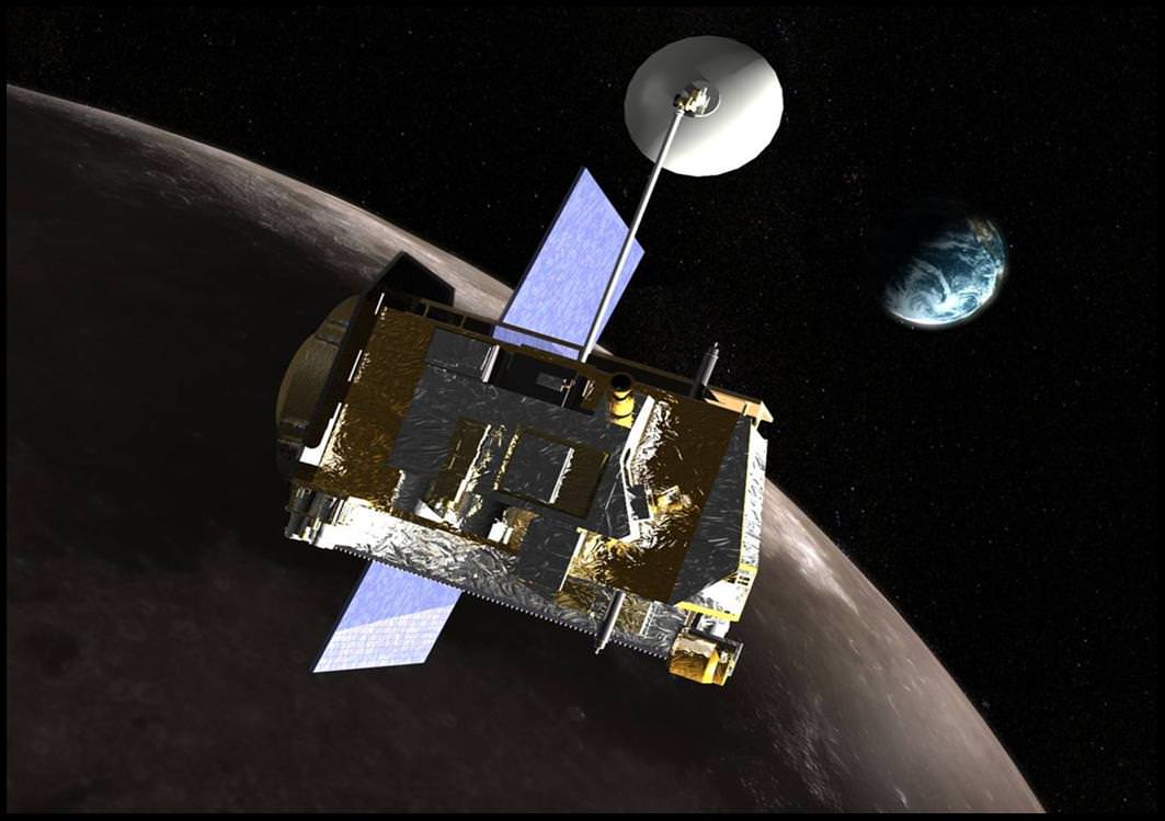
One year ago today, the Lunar Reconnaissance Orbiter (LRO) officially reached orbit about the Moon, and in the past 12 months has gathered more digital information than any previous planetary mission in history. NASA says that maps and datasets collected by LRO’s state-of-the-art instruments will form the foundation for all future lunar exploration plans, as well as be critical to scientists working to better understand the moon and its environment. To celebrate one year in orbit, here are ten great observations made by LRO.

LRO's Diviner instrument found the coldest place in the solar system. Credit: NASA/Goddard/University of California, Los Angeles

1. Coldest Place in the Solar System.

If you think Pluto, a KBO, or the farthest reaches of our solar system are cold, a location closer to Earth is actually colder. Diviner, LRO’s temperature instrument, found a place in the floor of the moon’s Hermite Crater that was detected to be -415 degrees Fahrenheit (-248 Celsius) making it the coldest temperature measured anywhere in the solar system. For comparison, scientists believe that Pluto’s surface only gets down to about -300 degrees Fahrenheit (-184 Celsius). Extremely cold regions similar to the one in Hermite Crater were found at the bottoms of several permanently shaded craters at the lunar south pole and were measured in the depths of winter night.

Enlargement of area surrounding Apollo 11 landing site. Credit: NASA/GSFC/Arizona State University

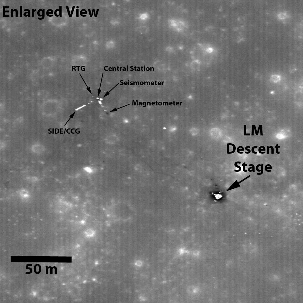
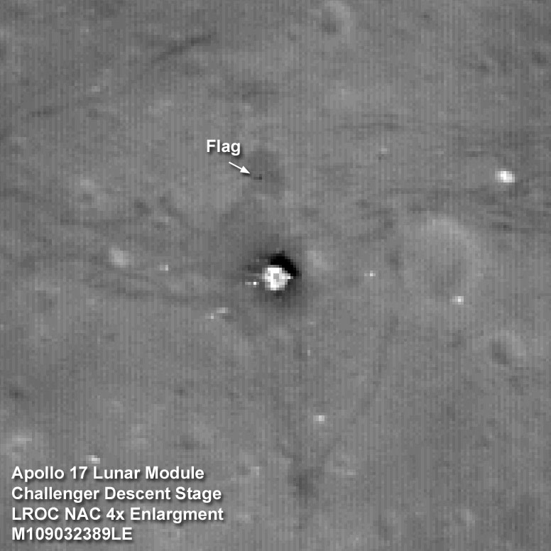
2. Where Humans Have Walked on the Moon

LRO’s views of the Apollo landing sites are nothing short of stunning, not to mention exciting. Above is LRO’s latest looks at the Apollo 11 landing site, which clearly shows where the descent stage (about 12 feet in diameter) was left behind as well as the astronauts’ tracks and the various equipment they deployed. This LRO data has important scientific value, as it provides context for the returned Apollo samples. Beyond their use for science, the images of all six manned landing sites observed by LRO provide a reminder of NASA’s proud legacy of exploration and a note of inspiration about what humans are capable of in the future.

A pit on the Moon. Credit: NASA/Goddard/Arizona State University

3. Caves on the Moon

What could be more exciting than finding a cave on the Moon, a potential future lunar habitat for human explorers? LRO has now collected the most detailed images yet of at least two lunar pits, quite literally giant holes in the moon. Scientists believe these holes are actually skylights that form when the ceiling of a subterranean lava tube collapses, possibly due to a meteorite impact punching its way through. One of these skylights, the Marius Hills pit, was observed multiple times by the Japanese SELENE/Kaguya research team. With a diameter of about 213 feet (65 meters) and an estimated depth of 260 to 290 feet (80 to 88 meters) it’s a pit big enough to fit the White House completely inside. The image featured here is the Mare Ingenii pit. This hole is almost twice the size of the one in the Marius Hills and most surprisingly is found in an area with relatively few volcanic features.

The Russian Lunokhod rover was imaged by LRO. Credit: NASA/Goddard/Arizona State University

4. Finding Missing Spacecraft

Lunokhod 1 was the name of a Russian robotic rover that landed on the moon in 1970 and navigated about 6 miles (10 km) of the lunar surface over 10 months before it lost contact in September 1971. Scientists were unsure of the rover’s whereabouts, though at least one team of researchers were searching for it, hoping to bounce a laser off of its retroreflector mirrors. This past March however, the LROC team announced they had spotted it, miles from the location the laser team had been searching. Using the info provided by LRO, a laser pulse was sent to Lunokhod 1 and contact was made with the rover for the first time in nearly four decades. Not only did Lunokhod 1’s retroreflector return a signal, but it returned one that was about five times better than those that have routinely been returned by Lunokhod 2’s mirrors over the years.

The Apollo 14 crew came close to seeing the rim of Cone Crater, but not quite. Credit: NASA/Goddard/Arizona State University

5. Apollo 14’s Near Miss of Seeing Cone Crater.

When the Apollo 14 crew of Alan Shepard and Edgar Mitchell walked across their landing site at Fra Maura, they hoped to be able to gather samples from the rim of Cone Crater. But they didn’t ever find the rim, and without a roadmap or guideposts along the way to help them find it, (and also they didn’t have the benefit of riding on the lunar rover so had to walk the entire time). They walked nearly a mile (1400 meters) and the steep incline of the crater rim made the climb difficult, raising the astronaut’s heart rates. Plus the tight schedule of the activity resulted in mission control ordering them to gather whatever samples they could and return to the landing module. They never reached the edge of the crater. Though geologists say it did not greatly affect the success of the scientific goal, the astronauts were personally disappointed in failing to make it to the top. Images from LRO now show precisely just how far the astronauts traveled and how close they came to reaching the crater, their tracks ending only about 100 feet (30 meters) from the rim!

The rim of Cabeus Crater. Credit: NASA/Goddard/Arizona State University

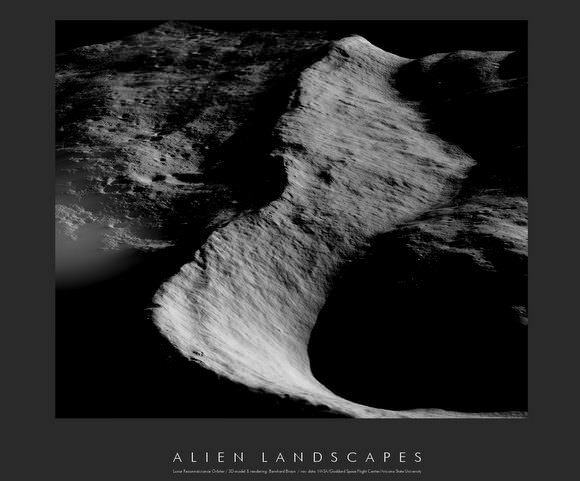
6. Mountains on the Moon.

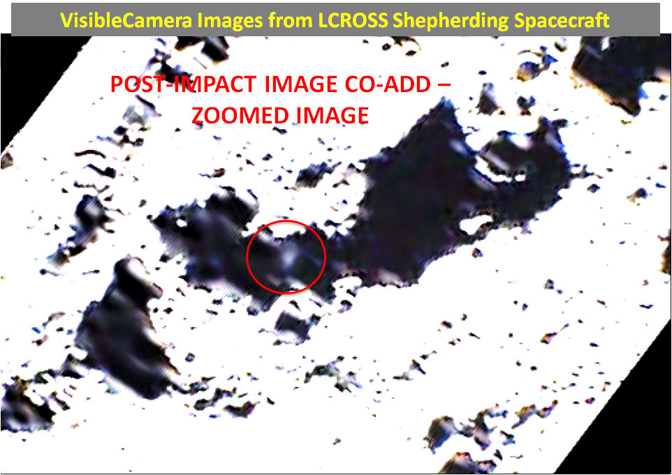
On the Earth, we are taught that mountains form over millions of years, the result of gradual shifting and colliding plates. On the moon however, the situation is quite different. Even the largest lunar mountains were formed in minutes or less as asteroids and comets slammed into the surface at tremendous velocities, displacing and uplifting enough crust to create peaks that easily rival those found on Earth. On a few occasions in the past year, NASA has tilted the angle of LRO to do calibrations and other tests. In such cases the camera has the opportunity to gather oblique images of the lunar surface like the one featured here of Cabeus Crater providing a dramatic view of the moon’s mountainous terrain. Cabeus Crater is located near the lunar south pole and contains the site of the LCROSS mission’s impact. Early measurements by several instruments on LRO were used to guide the decision to send LCROSS to Cabeus. During the LCROSS impact LRO was carefully positioned to observe both the gas cloud generated in the impact, as well as the heating at the impact site.

Lunar rilles. Image Credit: NASA/JHUAPL/LSI

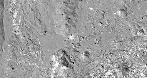
7. Lunar Rilles: Mysterious Channels on the Moon

Rilles are long, narrow depressions on the lunar surface that look like river channels. Some are straight, some curve, and others, like the ones highlighted here, are called “sinuous” rilles and have strong meanders that twist and turn across the moon. Rilles are especially visible in radar imagery, like that gathered by LRO’s Mini-RF instrument. The formation of lunar rilles is not well understood. It is believed there may be many different formation mechanisms including ancient magma flows and the collapse of subterranean lava tubes. Imagery from LRO will help researchers to better understand these mysterious “river-like” lunar features.

Areas of constant sunlight on the Moon's south pole. Image Credit: NASA/Goddard

8. Areas of Near Constant Sunlight at the South Pole

One of the most vital resources LRO is searching for on the moon is solar illumination. Light from the sun provides both warmth and a source of energy, two critical constraints to exploration efforts. The moon’s axis is only slightly tilted so there are areas in high elevations at its poles that remain almost constantly exposed to the sun. Using LRO’s precise measurements of topography scientists have been able to map illumination in detail, finding some areas with up to 96% solar visibility. Such sites would have continuous sun for approximately 243 days a year and never have a period of total darkness for more than 24 hours.

With Moon Zoo, you can count craters and boulders on the Moon to help lunar scientists. Credit: NASA/Goddard/Arizona State University

9. Moon Zoo lets you Help Lunar Scientists.

The latest Citizen Science project from the Zooniverse, Moon Zoo uses about 70,000 high resolution images gathered by LRO, and in these images are details as small as 50 centimeters (20 inches) across. ‘Zooites’ are asked to categorize craters, boulders and more, including lava channels and later, comparing recent LRO images to ones taken years ago by other orbiting spacecraft.

The first tasks are counting craters and boulders. By comparing and analyzing these feature counts across different regions as well as other places like the Earth and Mars, Zooites can help scientists gain a better understanding of our solar system’s natural history.

The Moon's far side -- the part we never see from Earth. Credit: NASA/Goddard

10. Getting a Good Look at the Far Side.

Tidal forces between the moon and the Earth have slowed the Moon’s rotation so that one side of the moon always faces toward our planet. Though sometimes improperly referred to as the “dark side of the moon,” it should correctly be referred to as the “far side of the moon” since it receives just as much sunlight as the side that faces us. The dark side of the moon should refer to whatever hemisphere isn’t lit at a given time. Though several spacecraft have imaged the far side of the moon since then, LRO is providing new details about the entire half of the moon that is obscured from Earth. The lunar far side is rougher and has many more craters than the near side, so quite a few of the most fascinating lunar features are located there, including one of the largest known impact craters in the solar system, the South Pole-Aitken Basin. The image highlighted here shows the moon’s topography from LRO’s LOLA instruments with the highest elevations up above 20,000 feet in red and the lowest areas down below -20,000 feet in blue.

See the LRO website for more info.

Source: NASA

A New Look at the Moon: Stunning 3-D Lunar Landscapes

Lunar Landscape. Credit: LROC; Goddard Space Flight Center and U of AZ, 3-D modeling and rendering by Bernhard Braun.

[/caption]

You may recall Bernhard Braun as the wizard from UnmannedSpaceflight.com who created the amazing 3-D images of the Mars avalanche. Now he’s created incredible planetary landscapes for a different world: the Moon. “Actually, this has been my very first attempt with lunar imagery after my previous work has almost been exclusively devoted to Mars,” Braun said. The special software he developed can create three dimensional images from one 2-dimensional picture, but he says the real stars are the spacecraft that gather the data, the Lunar Reconnaissance Orbiter and the Mars Reconnaissance Orbiter. “It is the unprecedented quality together with the unprecedented availability of the raw data that opens the door for everyone to explore new ideas and processing techniques,” Braun said.

See below for more stunning from-the-surface 3-D looks at the Moon – no special 3-D glasses needed!

Lunar Landscape. Credit: LROC; Goddard Spaceflight Center, U of AZ, 3-d rendering and modeling by Bernhard Braun.

I asked Braun if working with images from the Moon was different than working with Mars images. “Creating the single-image shading-derived DEMs from the Moon imagery is both easier and more difficult at the same time when compared to the same process applied to Mars images,” he said. “It’s easier because the lunar surface does not vary as much in its intrinsic albedo, i.e. the visible brightness variations are almost exclusively caused by variations in surface topography, especially at low illumination angles, which can be exploited by the reconstruction algorithm to derive high precision 3D geometry.”

But the work is more difficult because of the totally black shadows on the Moon due to lack of any atmosphere. “So on the Moon any shadows are virtually featureless areas where the 3-D reconstruction algorithm cannot infer anything about the structure of the invisible shadowed surface,” Braun said. “This is different on Mars, where the shadowed areas are usually lit indirectly by considerable amounts of ambient light scattered by dust particles suspended in the atmosphere. So the 3-D models of the Mars surface can be more complete, showing surface details even in shadowed areas.”

Lunar Landscape. Credit: LROC; Goddard Spaceflight Center, U of AZ, 3-d rendering and modeling by Bernhard Braun.

“All in all it’s a lot of fun to play around with both camera and sun positions until an interesting landscape shot is found,” Braun said. “I would like to add that much of the credit must really go to those true wizards at NASA/JPL for not only making and bringing to orbit these almost unearthly powerful cameras like LROC and HiRISE … but also for sharing the whole image catalog via the internet with everyone in the world!”

Braun said he hopes to tackle 3-D views of the Apollo landing sites — which we cannot wait to see!

Click on the images for links to higher resolution versions, or check out more of Braun’s Lunar Landscapes at this link. Our thanks to Bernhard for allowing us to post them on Universe Today

For more handiwork with images from space , check out UnmannedSpaceflight.com

You Too Can Find Missing Russian Spacecraft

This image, taken by Lunar Reconnaissance Orbiter's high-resolution camera, shows the final resting place of Lunokod 2, as well as the crater that caused its death. Credit: NASA / GSFC / Sergei Gerasimenko / Sasha Basilevsky, via the Planetary Society Blog

On Monday, NASA released the complete set of science data from the Lunar Reconnaissance Orbiter Camera’s first six months of observations, consisting of more than 100,000 lunar images. Straight away, Phil Stooke from the University of Western Ontario began scanning the images to help find a “missing” Russian rover on the lunar surface, the Lunokhod 2. It didn’t take him long to discover the tracks left by the lunar sampler 37 years ago after it made a 35-kilometer trek. “The tracks were visible at once,” said Stooke.

UPDATE: It turns out the original image that showed what Dr. Stooke thought was the Lunokhod 2 rover’s location was not quite correct. Emily Lakdawalla posted a story about it on The Planetary Society Blog, and so I checked with Stooke. He replied: “After I posted my “discovery” Sasha Basilevsky, a veteran Russian planetary scientist, sent me and Emily an image – the one she put on her blog – which shows the true situation. My dark spot is a dark marking the rover made as it turned in place before heading out on one last short drive. That took it out beyond the edge of my image. That new image shows the rover as a bright spot. Yes, I concur with their interpretation. My spot was made by the rover but it’s not actually the rover itself.”

So, I have updated the image above to show the actual final resting spot. The black arrow shows the spot that Stooke originally thought was the rover, where the white arrow shows the real rover. The smaller white arrows point out the rover’s tracks. (end of update)

And now that the images are readily available for anyone to see, who knows what you can find on the Moon?
Continue reading “You Too Can Find Missing Russian Spacecraft”

Look for “Flood” of News This Week About Water on the Moon

LCROSS Mission
Artist impression of LCROSS approaching the Moon. Credit: NASA

[/caption]

Almost five months ago, the LCROSS spacecraft had an abrupt end to its flight when it impacted a crater on the Moon’s south pole. But that was only the beginning of the work of principal investigator Tony Colaprete and the rest of the science teams, who have since been working non-stop to get their initial results out to the public. Look for a flood of ‘water on the Moon’ news to be announced at the Lunar and Planetary Science Conference this week.

“The data set from LCROSS is a lot more interesting that we thought it would be,” said Colaprete, speaking on a “My Moon” webcast, sponsored by the Lunar and Planetary Institute. “A big part of our time has been making sure the data is properly calibrated. That takes a lot of time and effort, but the other side of the equation is understanding all the stuff you don’t understand in the data, and there was a lot we didn’t initially understand.”

The LCROSS team will present six papers, 11 posters and several oral sessions at the LPSC.
While the results are still under embargo, Colaprete was able to discuss the basics of what the science teams have found.

LCROSS impact site. Credit: NASA

One surprise for the teams was the low “flash” produced by the impact of the spacecraft. “We didn’t see a visible flash, even with sensitive instruments,” Colaprete said. “There was a delayed and muted flash and the impactor was essentially buried, with all the energy apparently deposited at a depth. So it is very likely that there were volatiles in the vicinity.”

The second surprise was the morphology of the impact plume. “We had reason to believe there would be high angle plume,” said Colaprete. “But we had a lower angle plume. We had a signal of a debris curtain in the spectrometers in LCROSS all the way down in the four minutes following the impact of the Centaur stage. That was corroborated with DIVINER measurements with LRO (a radiometer on the Lunar Reconnaissance Orbiter.) They were able to make some great observations of the ejecta cloud with DIVINER, and we had good signals with our instruments all the way down to impact.”

Most surprising, Colaprete said, was all the “stuff” that came up from the impact. “Everyone was really excited and surprised about all the stuff that we threw up with the impact.”

The LRO spacecraft was able to be tilted in orbit so the LAMP (Lyman-Alpha Mapping Project) instrument could observe impact plume. It observed a plume about 20 km tall, and observed a “footprint” of a plume up to 40 km above the Moon’s surface.
“They saw vapor cloud fill the ‘slit’ of the spectrometer’s observations at about 23 seconds after impact and it remained there through the entire flyby,” Colaprete said. “What that corresponds to is a hot vapor cloud of about 1000 degrees that was observed.”

A closer view of the moon as the LCROSS spacecraft approaches impact. Credit: NASA

Two exciting species found in the cloud were molecular hydrogen and mercury. “What is fantastic about that, is that there was an article written a couple of decades ago, regarding the possibility of mercury and water at the poles, and they said don’t drink the water!”

Colaprete said observing molecular hydrogen is spectacular because normally it doesn’t stay stable even at 40 Kelvin. The teams are still speculating how it was trapped and what form it was in. They found about 150 kg of molecular hydrogen in the plume.

All the elements found in the plume must be coming from cometary and asteroidal sources, Colaprete said. They also found water ice, sulfur dioxide, methane, ammonia, methanol, carbon dioxide, sodium and potassium. “We haven’t identified everything yet, but what we’re seeing is similar to what you would see in an impact of a comet, like what happened with the Deep Impact probe, which is exciting and surprising. The mineralogy in the dust itself that we kicked up corresponds to what was seen by M Cubed instrument, and also what we see in chondrite asteroids.”

One of the most pleasing aspects of this scientific process, Colaprete said, was the different teams being able to verify what other teams were finding.

“The concentration of hydrogen we saw in the regolith was higher than expected,” Colaprete said. “We ran the numbers again, and we said, ‘Oh, we can’t wiggle out of this answer.’ Then the PI for the LEND (Lunar Exploration Neutron Detector on LRO, which can acquire high-resolution neutron datasets) instrument confirmed that their numbers were entirely consistent with what we got. It was surprising because it wasn’t what we expected. But that is why you make measurements.”

“This should be a fun year as we pull this all together, and get it released to the public so we can get a lot more neurons looking at this,” Colaprete said. “I think this will really change our understanding of the Moon and how we think about it.”

LRO Finds Some Surprises on the Moon

Bruno Crater. Taken by: LROC Narrow Camera. Image Credit: NASA/GSFC/Arizona State University

[/caption]
The Lunar Reconnaissance Orbiter (LRO) is getting the closest look yet at the Moon from orbit, providing crucial insights to help prepare for a possible return of humans to the lunar surface. “There is a lot of natural beauty on the Moon,” said Mike Wargo, NASA’s chief lunar scientist, speaking at the American Geophysical Union meeting on Tuesday. “LRO is collecting data to support a return to the Moon, studying a diverse and representative set of sites selected on scientific, engineering, and resource potential and representative of the wide range of terrains present on the Moon.”

Scientists explained how various instruments on LRO are returning surprising data while helping scientists map the moon in incredible detail and understand the lunar environment.

LROC, or the LRO Camera, has now mapped in high resolution all the Apollo landing sites and 50 sites that were identified by NASA’s Constellation Program to be representative of the wide range of terrains present on the moon.

Some of the most intriguing images revisit the sites of humankind’s first forays beyond Earth orbit.

Enlargement of area surrounding Apollo 11 landing site. Credit: NASA/GSFC/Arizona State University

“Imaging the Apollo landing sites have served a practical purpose,” said Mark Robinson, LROC principal investigator, “as we are using them in lieu of stars to calibrate the LROC Narrow Angle Cameras. Plus these images are much more fun than stars, because we get to see where humans used to walk. It’s also much less stress on the spacecraft because you don’t have to slew in and out to look at the stars.”

Since the locations of the Apollo spacecraft and other hardware left by the astronauts are known to about nine feet absolute accuracy, Robinson said they can tie the Narrow Angle Camera geometric and timing calibration to the coordinates of the Apollo Laser Ranging Retroreflectors and Apollo Lunar Surface Experiments Packages. “This ground truth enables more accurate coordinates to be derived for virtually anywhere on the moon. Scientists are currently analyzing brightness differences of the surface material stirred up by the Apollo astronauts, comparing them with the local surroundings to estimate physical properties of the surface material. Such analyses will provide critical information for interpreting remote sensing data from LRO, as well as from India’s Chandrayaan-1, and Japan’s Kaguya missions.”

Robinson said the soil compacted by the Apollo astronauts and lunar rovers is darker than undisturbed soil. “Disturbing the soil changes the brightness by a factor of two,” he said.

LRO’s Diviner instrument has discovered that the bottoms of polar craters in permanent shadow can be brutally cold. Mid-winter nighttime surface temperatures inside the coldest craters in the north polar region dip down to 26 Kelvin (416 below zero Fahrenheit, or minus 249 degrees Celsius). “These are the coldest temperatures that have been measured thus far anywhere in the solar system. You may have to travel to Kuiper Belt to find temperatures this low” said David Paige, principal investigator for the Diviner Lunar Radiometer Experiment. “The temperatures we are observing both day and night are way cold enough to preserve water ice for extended periods, as well as a wide range of compounds such as carbon dioxide and organic molecules. There could be all kinds of interesting compounds trapped there.”

Paige also noted that it turns out the moon does have seasons. “The Moon has a tilt of 1.54 degrees, so at most latitudes the lunar seasons are hardly noticeable,” he said, “but at Polar Regions, there are significant variation in shadows and temperatures because of this tilt.”

The Cosmic Ray Telescope for the Effects of Radiation, or CRaTER, is measuring the amount of space radiation at the Moon to help determine the level of protection required for astronauts during lengthy expeditions on the moon or to other solar system destinations.

“This surprising solar minimum, or quiet period for the sun regarding magnetic activity, has led to the highest level of space radiation in the form of Galactic Cosmic Rays, or GCRs, fluxes and dose rates during the era of human space exploration,” said Harlan Spence, principal investigator the CRaTER instrument. “The rarest events – cosmic rays with enough energy to punch through the whole telescope – are seen once per second, nearly twice higher than anticipated. Crater radiation measurements taken during this unique, worst-case solar minimum will help us design safe shelters for astronauts.”

GCRs are electrically charged particles – electrons and atomic nuclei – moving at nearly the speed of light into the solar system. Magnetic fields carried by the solar wind deflect many GCRs before they approach the inner solar system. However, the sun is in an unusually long and deep quiet period, and the interplanetary magnetic fields and solar wind pressures are the lowest yet measured, allowing an unprecedented influx of GCRs.

Scientists expected the level of GCRs to drop as LRO got closer to the moon for its mapping orbit. This is because GCRs come from all directions in deep space, but the moon acts as a shield, blocking the particles behind it across about half the sky in close lunar proximity.

“But surprisingly, as we went closer to surface, amount of radiation decrease did not happen as quickly as predicted,” said Spence. “The difference is that the Moon is a source of secondary radiation. This is likely due to interactions between the Galactic Cosmic Rays and the lunar surface. The primary GCRs produce secondary radiation by shattering atoms in the lunar surface material; the lunar surface then becomes a significant secondary source of particles, and the resulting radiation dose is thereby 30-40 percent higher than expected.”

But Spence said the amount of radiation shouldn’t be a showstopper, as far as future human missions to the Moon. The amount of radiation, even at its highest, is comparable to US yearly exposure limits for people with occupational exposure such as x-ray technicians or uranium miners.

The team also wants to see what the radiation environment on the Moon is like during an active solar cycle – but they might have to wait awhile.

“We’re eager to see a big solar flare, so we can evaluate the hazards from solar-generated cosmic rays, but we’ll probably have to wait a couple years until the sun wakes up,” said Spence.

Wargo said the LRO findings emphasizes the importance of engaging the scientific community for exploration. “The work being done in heliophysics areas is important to keeping astronauts safe,” he said, “as well as being able to model the activity of the sun and the generations of energetic solar particles. One of the ‘holy grails’ would be to be able predict the the Sun’s activities and be able to give an ‘all clear’ of how many days when astronauts could be on an EVA and what the likelihood of solar energetic particles being emitted from the sun. The work we are doing to enable exploration is helping our scientific understanding.”

LRO is expected to return more data about the moon than all previous orbital missions combined.

Source: AGU Press conference, press release

LRO’s Closer Look at the Apollo 12 Landing Site

Close-up view of Apollo 12 landing site from LRO. Credit: NASA/GSFC/Arizona State University

Wow! Just look at the detail visible in this image of the Apollo 12 landing site taken by the Lunar Reconnaissance Orbiter from its lower mapping orbit of 50 km above the surface. Compared to earlier images taken in September when LRO was in a higher orbit, the Lunar Module descent stage really stands out, as well as the Apollo Lunar Surface Experiment Package (ALSEP). Also visible are the trails left by spacewalking astronauts. From this and other LROC landing site images, it is clear that astronaut activity lowers the albedo, or reflectivity of the surface. Areas of heaviest activity have the lowest albedo, especially around the LM. NASA says this effect is most likely due to compaction of a very loose surface powder by the astronauts just walking around.


The Apollo 12 landing site as seen by LRO. Credit: NASA/GSFC/Arizona State University

Here is a slightly more zoomed out version that includes the Surveyor 3 spacecraft. The Sun is very high in the sky (incidence angle 4°) for these images and shadows are minimized.

Below is an image taken by the astronauts as they set up the ALSEP instruments.
apollo 12 alsep

Source: NASA

LRO Takes Closer Look at Apollo 17 Landing Site

The Apollo 17 Lunar Module Challenger descent stage comes into focus from the new lower 50-km mapping orbit, image width is 102 meters [NASA/GSFC/Arizona State University].

.”]
The Lunar Reconnaissance Orbiter maneuvered into its 50-km mapping orbit on September 15, which enables it to take a closer look at the Moon than any previous orbiter. This also allows for comparing previous images taken by LRO when it was at its higher orbit. Here’s the Apollo 17 landing site: just look at what is all visible, especially in the image below! These images have more than two times better resolution than the previously acquired images.

Region of Taurus-Littrow valley around the Apollo 17 landing site. NASA/GSFC/Arizona State University.

At the time of this recent pass, the Sun was high in the sky (28° incidence angle) helping to bring out subtle differences in surface brightness. The descent stage of the lunar module Challenger is now clearly visible, at 50-cm per pixel (angular resolution) the descent stage deck is eight pixels across (four meters), and the legs are also now distinguishable. The descent stage served as the launch pad for the ascent stage as it blasted off for a rendezvous with the command module America on December 14, 1972.

Also visible is the ALSEP, the Apollo Lunar Surface Experiments, which for Apollo 17 included 1) Lunar Seismic Profiling Experiment (geophones), 2) Lunar Atmospheric Composition Experiment (LACE) to measure the composition of the Moon’s extremely tenuous surface bound exosphere, 3) Lunar Ejecta and Meteorites (LEAM) experiment, 4) central station, 5) Heat Flow Experiment, 6) all powered by a Radioisotope Thermoelectric Generator (RTG). Below is how it looked from the surface, taken by the Apollo astronauts.

View of the ALSEP looking south-southeast.  Credit: NASA
View of the ALSEP looking south-southeast. Credit: NASA

Compare these most recent images to one taken previously.

Apollo 17 LRO. Credit: NASA

See more images from LRO’s previous looks at the Apollo landing sites

See more at the LROC site.

LRO, Chandrayaan-1 Scientist Arrested for Espionage

Nozette with a model of Chandrayaan-1. Credit: NDTV

Times are tough, but you have to wonder what this guy was thinking. Stewart David Nozette, 52, who was involved in the recent discovery of water on the Moon by the Chandrayaan-1 spacecraft has been arrested for espionage for allegedly trying to sell details of US missile detection satellites in exchange for cash. Nozette was attempting to sell classified information to a person who he believed was an Israeli intelligence officer. Nozette is a fairly prominent scientist who helped conceive the 1994 Clementine mission to the Moon, and currently is a co-investigator on Chandrayaan-1, the Indian Moon mission, and on an instrument aboard the Lunar Reconnaissance Orbiter.

According to a 16th October FBI affidavit, Nozette was contacted last month by an undercover officer posing as an agent working for the Israeli Intelligence Agency. Nozette agreed to accept money in exchange for his past access to top secret documents.

As former government physicist, allegedly Nozette worked for almost every military shop in the US government including the Air Force’s Phillips Laboratory, the Ballistic Missile Defense Organization, Lawrence Livermore National Laboratory, the Naval Research Laboratory, and the Defense Advanced Research Project’s Administration (DARPA). He also served on president George H. W. Bush’s space council and worked with NASA.

This isn’t the first time Nozette has been in trouble with the government. According to press reports, a small non-profit Nozette ran came under investigation by NASA in 2006 for misusing funds to pay for utilities, three mortgages a tennis club membership.

But this time the charges are more serious.

According to the Nature Blog, Nozette has worked for with Israeli contacts previously. The FBI affidavit says that between 1998 and 2008, an Israeli aerospace company “wholly owned by the Government of the State of Israel” paid Nozette some $225,000. “I thought I was working for you already,” Nozette told the agent in a transcript reproduced in the affidavit. “I mean that’s what I always thought, the [foreign company] was just a front.”

In September and October, Nozette allegedly provided details of a “prototype overhead collection system” to the FBI agent in exchange for cash payments of $2,000 and $9,000 dollars. He will appear later today in United States District court for the District of Columbia to face a single charge of attempted espionage.

Sources: Nature Blog, NDTV

Moon Crash Plume Visible to Spacecraft But Not Earth Telescopes

Zoomed in image of the impact plume. The extent of the plume at 15 sec is approximately 6-8 km in diameter. Credit: NASA

Nine science instruments on board the LCROSS spacecraft captured the entire crash sequence of the Centaur impactor before the spacecraft itself impacted the surface of the moon. But from Earth, any evidence of the plume was hidden by the rim of a giant impact basin, a 3 kilometer-high (2-mile) mountain directly in the way for Earth telescopes trained on the impact site, said Dr. Peter Schultz, co-investigator for LCROSS. Additionally, the crater created by the impact was only about 28 meters across (92 feet) but Schultz said the best resolution Earth telescopes can garner is about 180 meters (200 yards) across.

The science team is analyzing the data returned by LCROSS, and Anthony Colaprete, principal investigator and project scientist, said “We are blown away by the data returned. The team is working hard on the analysis and the data appear to be of very high quality.”

The team hopes to release some of their preliminary findings within the next several weeks, Schultz said at in webcast with students and teachers this week.

During the Oct. 9 crash in to the Moon’s Cabeus crater, the nine LCROSS instruments successfully captured each phase of the impact sequence: the impact flash, the ejecta plume, and the creation of the Centaur crater.

Within the ultraviolet/visible and near infra-red spectrometer and camera data was a faint, but distinct, debris plume created by the Centaur’s impact.

“There is a clear indication of a plume of vapor and fine debris,” said Colaprete. “Within the range of model predictions we made, the ejecta brightness appears to be at the low end of our predictions and this may be a clue to the properties of the material the Centaur impacted.”

The magnitude, form, and visibility of the debris plume add additional information about the concentrations and state of the material at the impact site.

From images and data, the team was able to determine the extent of the plume at 15 seconds after impact was approximately 6-8 km in diameter. Schultz said the Moon’s gravity pulled down most of ejecta within several minutes.

The LCROSS spacecraft also captured the Centaur impact flash in both mid-infrared (MIR) thermal cameras over a couple of seconds. The temperature of the flash provides valuable information about the composition of the material at the impact site. LCROSS also captured emissions and absorption spectra across the flash using an ultraviolet/visible spectrometer. Different materials release or absorb energy at specific wavelengths that are measurable by the spectrometers.

the locations of the Diviner LCROSS impact swaths overlain on a grayscale daytime thermal map of the Moon’s south polar region. Diviner data were used to help select the final LCROSS impact site inside Cabeus Crater, which sampled an extremely cold region in permanent shadow that can serve as an effective cold trap for water ice and other frozen volatiles. Credit NASA/GSFC/UCLA

Additionally, the Lunar Reconnaissance Orbiter’s Diviner instrument also obtained infrared observations of the LCROSS impact. LRO flew by the LCROSS Centaur impact site 90 seconds after impact at a distance of ~80 km. Both science teams are working together to analyze the their data.

The LCROSS spacecraft captured and returned data until virtually the last second before impact, Colaprete said, and the thermal and near-infrared cameras returned excellent images of the Centaur impact crater at a resolution of less than 6.5 feet (2 m).

“The images of the floor of Cabeus are exciting,” said Colaprete. “Being able to image the Centaur crater helps us reconstruct the impact process, which in turn helps us understand the observations of the flash and ejecta plume.”

Sources: LCROSS, LCROSS webcast