The study of tree rings may help prepare for space weather events that could threaten satellites and astronauts. Amy Hessl, professor of geography at WVU, is leading a project funded by the National Science Foundation.
One of the many threats facing space travellers and indeed our own planet is that of Solar Storms. At their most minor they can grant polar latitudes with a gentle auroral display but at their most extreme they can pose a threat to technology in space, communications and even our atmosphere. Now a team of researchers have found that extreme space weather can leave its mark in tree rings, leaving evidence that can help guard against future severe events.
A solar flare erupts on the Sun. Credit: NASA/GSFC/SDO
On December 14th, at 12:02 PM Eastern (09:02 AM Pacific), the Sun unleashed a massive solar flare. According to the Space Weather Prediction Center, part of the National Oceanic Atmospheric Administration (NOAA), this was the strongest flare of Solar Cycle 25, which began in 2019 and will continue until 2030. What’s more, scientists at the SWPC estimate that this may be one of the most powerful solar flares recorded since 1755 when extensive recording of solar sunspot activity began.
Precipitation is much more widespread throughout that solar system than commonly assumed. Obviously it rains water on Earth. But it snows carbon dioxide on Mars, rains methane on Titan, sulfuric acid on Venus, and could potentially rain diamonds on Neptune. The type of material falling out of the sky is almost as varied as the planets themselves. New research from a team led by Kaitlyn Loftus at Harvard found a similarity for all of the liquid materials that constitute rain throughout the solar system – all of the drops, no matter the material, are roughly the same size.
A massive prominence erupts from the surface of the sun. Credit: NASA Goddard Space Flight Center
The Sun is not exactly placid, though it appears pretty peaceful in the quick glances we can steal with our naked eyes. In reality though, the Sun is a dynamic, chaotic body, spraying out solar wind and radiation and erupting in great sheets of plasma. Living in a technological society next to all that is a challenge.
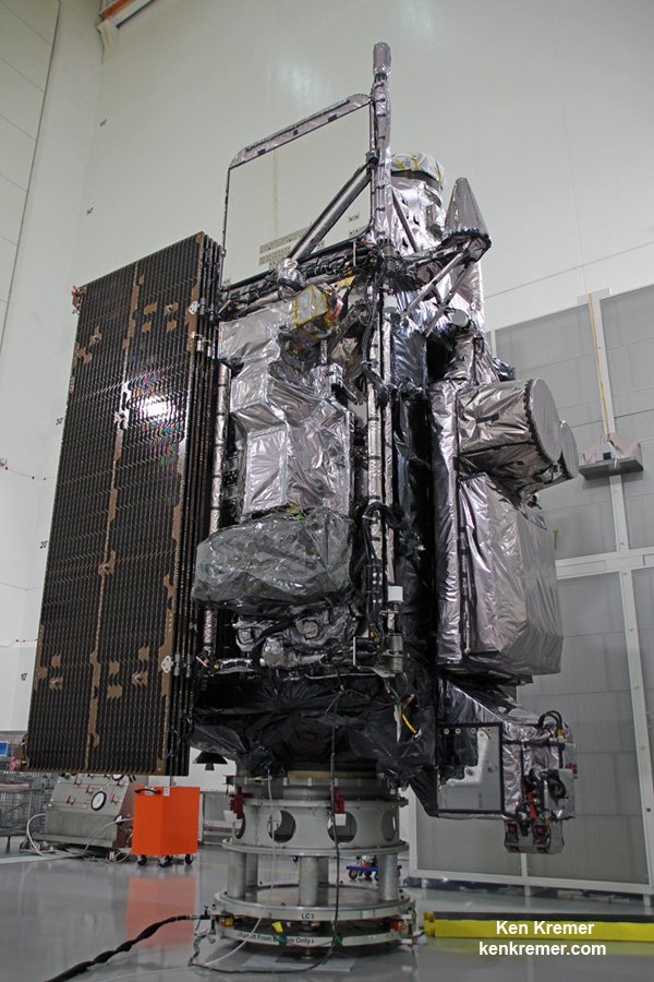
The NASA/NOAA GOES-R (Geostationary Operational Environmental Satellite - R Series) being processed at Astrotech Space Operations, in Titusville, FL, in advance of launch on a ULA Atlas V on Nov. 19, 2016. GOES-R will be America’s most advanced weather satellite. Credit: Ken Kremer/kenkremer.com
The NASA/NOAA GOES-R (Geostationary Operational Environmental Satellite – R Series) being processed at Astrotech Space Operations, in Titusville, FL, in advance of planned launch on a ULA Atlas V slated for Nov. 19, 2016. GOES-R will be America’s most advanced weather satellite. Credit: Ken Kremer/kenkremer.com
KENNEDY SPACE CENTER, FL – After an ironic detour due to Hurricane Matthew, liftoff of the game changing NASA/NOAA next generation GOES-R geostationary weather observation satellite offering a “dramatic leap in capability” is finally on track for this weekend on Nov. 19 from the Florida Space Coast.
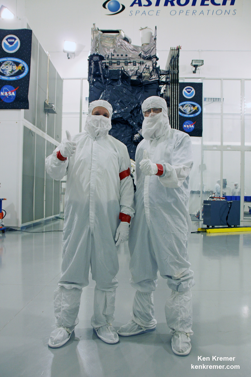
And Universe Today recently got an up close look and briefing about the massive probe inside the cleanroom processing facility at Astrotech Space Operations in Titusville, Fl.
“We are bringing the nation a new capability .. that’s a dramatic leap .. to scan the entire hemisphere in about 5 minutes,” said Greg Mandt, NOAA GOES-R program manager during a briefing in the Astrotech cleanroom.
“GOES-R has both weather and space weather detection capabilities!” Tim Gasparrini, GOES-R program manager for Lockheed Martin, told Universe Today during a cleanroom interview.
Astrotech is located just a few miles down the road from NASA’s Kennedy Space Center and the KSC Visitor Complex housing the finest exhibits of numerous spaceships, hardware items and space artifacts.
The NASA/NOAA GOES-R (Geostationary Operational Environmental Satellite – R Series) being processed at Astrotech Space Operations, in Titusville, FL, in advance of planned launch on a ULA Atlas V slated for Nov. 19, 2016. GOES-R will be America’s most advanced weather satellite. Credit: Ken Kremer/kenkremer.com
GOES-R, which stands for Geostationary Operational Environmental Satellite – R Series – is a new and advanced transformational weather satellite that will vastly enhance the quality, speed and accuracy of weather forecasting available to forecasters for Earth’s Western Hemisphere.
Liftoff of the NASA/NOAA GOES-R weather satellite atop a United Launch Alliance (ULA) Atlas V rocket is now scheduled for Saturday, Nov. 19 at 5:42 p.m. from Space Launch Complex 41 (SLC-41) on Cape Canaveral Air Force Station, shortly after sunset.
The launch window extends for an hour from 5:42-6:42 p.m. EST.
GOES-R is the first in a new series of American’s most powerful and most advanced next generation weather observation satellites. It is designed to last for a 15 year orbital lifetime.
Once in orbit it will be known as GOES-16. TV viewers are presently accustomed to seeing daily streams of imagery from the GOES-East and GOES-West weather observation satellites currently in orbit.
What’s the big deal about GOES-R?
Audiences will notice big changes from GOES-R once it becomes operational because it will provide images of weather patterns and severe storms as regularly as every five minutes or as frequently as every 30 seconds.
“These images can be used to aid in weather forecasts, severe weather outlooks, watches and warnings, lightning conditions, maritime forecasts and aviation forecasts.
“It also will assist in longer term forecasting, such as in seasonal predictions and drought outlooks. In addition, space weather conditions will be monitored constantly, including the effects of solar flares to provide advance notice of potential communication and navigation disruptions. It also will assist researchers in understanding the interactions between land, oceans, the atmosphere and climate.”
GOES-R was built by prime contractor Lockheed Martin and is the first of a four satellite series – comprising GOES-R, S, T, and U that will be keep the GOES satellite system operational through 2036.
All four of the revolutionary 11,000 pound satellites are identical. The overall cost is about $11 Billion.
“This is a very exciting time,” explained Greg Mandt, the NOAA GOES-R program manager during the Astrotech cleanroom briefing.
“This is the culmination of about 15 years of intense work for the great team of NOAA and NASA and our contractors Lockheed Martin and Harris.”
“We are bringing the nation a new capability. The GOES program has been around for about 40 years and most every American sees it every night on the weather broadcasts when they see go to the satellite imagery. And what’s really exciting is that for the first time in that 40 years we are really end to end replacing the entire GOES system. The weather community is really excited about what we are bringing.”
“It’s a dramatic leap in capability – like moving from black and white TV to HDTV.”
“We will be able to scan the entire hemisphere in about 5 minutes and do things so much faster with double the resolution.”
The NASA/NOAA/Lockheed Martin/Harris GOES-R team gives a big thumbs up for the dramatic leap in capability this next gen weather observation satellite will provide – during media briefing at Astrotech Space Operations, in Titusville, FL. Launch is set for Nov. 19, 2016. Credit: Ken Kremer/kenkremer.com
It was built in facilities in Bucks County, Pennsylvania and Denver, Colorado. It arrived at Astrotech in August for final processing and checkouts of the spacecraft and instruments.
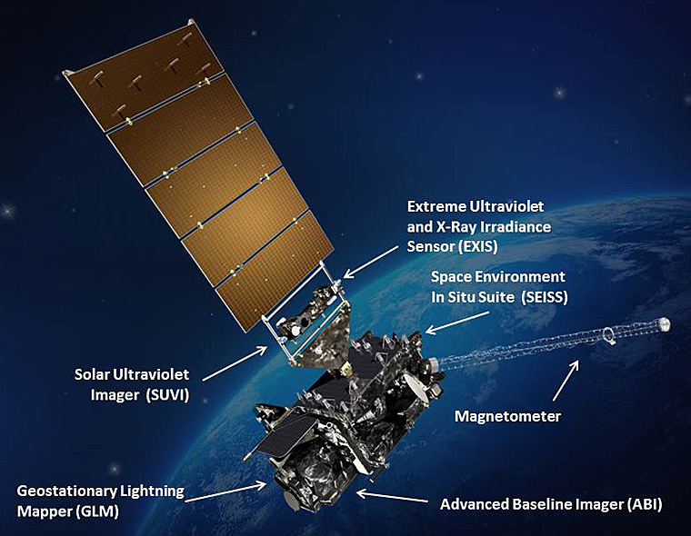
The gigantic school bus sized satellite is equipped with a suite of six instruments or sensors that are the most advanced of their kind. They will be used for three types of observations: Earth sensing, solar imaging, and space environment measuring. They will point to the Earth, the Sun and the in-situ environment of the spacecraft.
The suite includes the Advanced Baseline Imager (ABI), Geostationary Lightning Mapper (GLM), Solar Ultraviolet Imager (SUVI), Extreme Ultraviolet and X-Ray Irradiance Sensors (EXIS), Space Environment In-Situ Suite (SEISS), and the Magnetometer (MAG).
The two Earth-pointing instruments are on the top of the spacecraft – namely ABI and GLM.
“ABI is the premier instrument on the spacecraft. When you turn on the news and see a severe storm picture, that’s the one it comes from. It takes pictures in the visible as well as the infrared (IR), near infrared (IR),” Tim Gasparrini, GOES-R program manager for Lockheed Martin, told Universe Today during a cleanroom interview.
“It is looking for things like moisture, vegetation, aerosols and fire. So it looks across a broad spectrum to determine the environmental conditions on Earth.”
ABI offers 3 times more spectral channels with 4 times greater resolution and scans 5 times faster than ever before, compared to the current GOES satellites.
The GOES-R ABI will view the Earth with 16 different spectral bands (compared to five on current GOES), including two visible channels, four near-infrared channels, and ten infrared channels, according to the mission fact sheet.
It will also carry the first operational lightning mapper ever flown in space – GLM – built by Lockheed Martin. It has a single-channel, near-infrared optical transient detector.
“This is the first lightning mapper in space and at geostationary orbit.”
“GLM takes a picture of a scene on the Earth 500 times per second. And it compares those images for a change in the scene that can detect lightning, using an algorithm,” Gasparrini told me.
“The importance of that is lightning is a precursor to severe weather. So they are hoping that GLM will up to double the tornado warning time. So instead of 10 minutes warning you get 20 minutes warning, for example.”
GLM will measure total lightning (in-cloud, cloud-to-cloud and cloud-to-ground) activity continuously over the Americas and adjacent ocean regions with near-uniform spatial resolution of approximately 10 km.
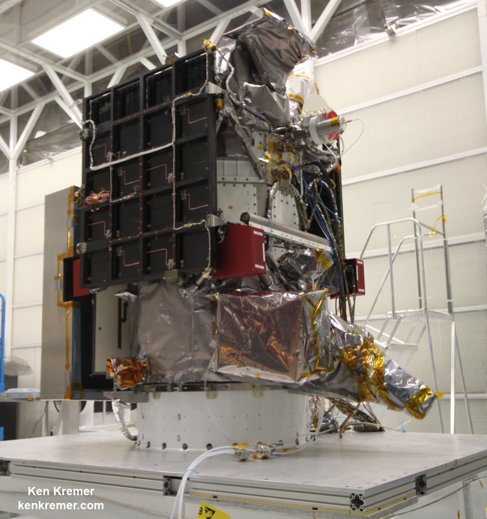
Side view of NASA/NOAA GOES-R next gen weather observation satellite showing solar panels and instruments inside Astrotech Space Operations cleanroom, in Titusville, FL. Launch is set for Nov. 19, 2016. Credit: Ken Kremer/kenkremer.com
“The two solar pointing instruments are located on a platform that constantly points them at the sun – SUVI (built by Lockheed Martin and EXIS. SUVI looks at the sun in the ultraviolet and EXIS looks at the x-ray wavelengths.”
The instruments work in concert.
“SUVI detects a solar flare on he sun and EXIS measures the intensity of the flare. As it comes towards the Earth, NOAA then uses the DSCOVR satellite [launched last year] as sort of a warning buoy about 30 minutes before the Earth. This gives a warning that a geomagnetic storm is heading toward the Earth.”
“When the storm reaches the Earth, the magnetometer instrument (MAG) on GOES-R then measures the influence of the magnetic storm on the magnetic field of the Earth.”
“Then the SEISS instrument, a charged particle detector, measures the charged particle effect of the storm on the Earth at geostationary orbit.”
“So GOES-R has both weather and space weather detection capabilities!” Gasparini elaborated.
The huge bus sized satellite measures 6.1 m x 5.6 m x 3.9 m (20.0 ft x 18.4 ft x 12.8 ft) with a three-axis stabilized spacecraft bus.
It has a dry mass of 2,857 kg (6,299 lbs) and a fueled mass of 5,192 kg (11,446 lbs) at launch.
The instruments are very sensitive to contamination and the team is taking great care to limit particulate and molecular contaminants in the cleanroom. Some of the instruments have contamination budget limits of less than 10 angstroms – smaller than the diameter of a typical molecule. So there can’t even be a single layer of molecules on the instruments surface after 15 years on orbit.
GOES-R can also multitask according to a NASA/NOAA factsheet.
“It can scan the Western Hemisphere every 15 minutes, the Continental U.S. every 5 minutes and areas of severe weather every 30-60 seconds. All at the same time!”
GOES-R will blastoff on a ULA Atlas V in the very powerful 541 configuration, augmented by four solid rocket boosters on the first stage. The payload fairing is 5 meters (16.4 feet) in diameter and the upper stage is powered by a single-engine Centaur.
It will be launched to a Geostationary orbit some 22,300 miles above Earth.
The Atlas V booster has been assembled inside the Vertical Integration Facility (VIF) at SLC-41 and will be rolled out to the launch pad Friday morning, Nov. 18 with the GOES-R weather satellite encapsulated inside the nose cone.
The weather forecast shows a 80 percent chance of favorable weather conditions for Saturday’s sunset blastoff.
GOES-R logo. Credit: NASA/NOAA
Stay tuned here for Ken’s continuing Earth and Planetary science and human spaceflight news.
Learn more about GOES-R weather satellite, Heroes and Legends at KSCVC, OSIRIS-REx, InSight Mars lander, ULA, SpaceX and Orbital ATK missions, Juno at Jupiter, SpaceX AMOS-6 & CRS-9 rocket launch, ISS, ULA Atlas and Delta rockets, Orbital ATK Cygnus, Boeing, Space Taxis, Mars rovers, Orion, SLS, Antares, NASA missions and more at Ken’s upcoming outreach events:
Nov 17-20: “GOES-R weather satellite launch, OSIRIS-Rex, SpaceX and Orbital ATK missions to the ISS, Juno at Jupiter, ULA Delta 4 Heavy spy satellite, SLS, Orion, Commercial crew, Curiosity explores Mars, Pluto and more,” Kennedy Space Center Quality Inn, Titusville, FL, evenings
GOES-R infographic
Tim Gasparinni, GOES-R program manager for Lockheed Martin, and Ken Kremer/University Today pose with GOES-R revolutionary weather satellite inside Astrotech Space Operations cleanroom, in Titusville, FL, and built by NASA/NOAA/Lockheed Martin/Harris. Credit: Ken Kremer/kenkremer.com
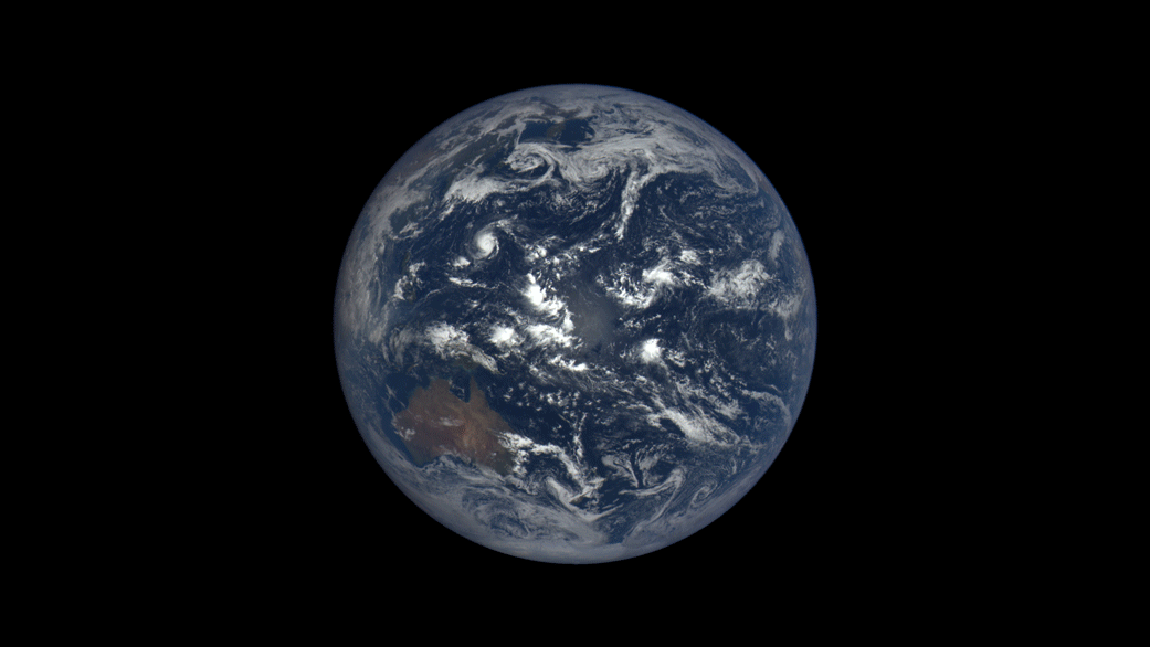
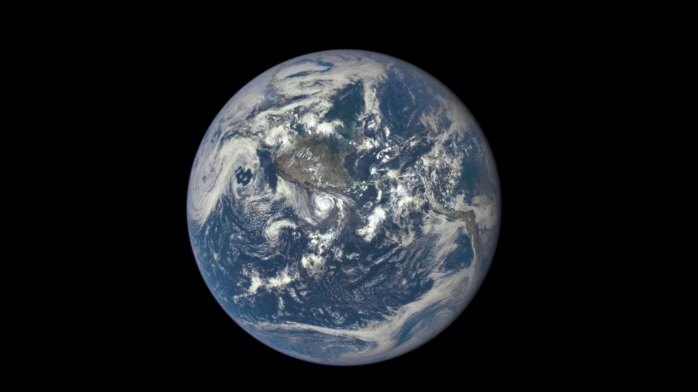
Earth rotates through an entire day as captured in this animation of 22 still images taken on Sept. 17, 2015 by NASA’s Earth Polychromatic Imaging Camera (EPIC) camera on the Deep Space Climate Observatory (DSCOVR) spacecraft. Credits: NASA
The EPIC camera, which stands for Earth Polychromatic Imaging Camera (EPIC), is located a million miles away on the DSCOVR real time space weather monitoring satellite and is designed to take full disk color images of the sunlit side of our home planet multiple times per day.
The EPIC NASA images are literally just a finger tip away, after a 17 year wait to get the satellite into the launch queue since it was first proposed by former VP Al Gore. They are all easily viewed at NASA’s new EPIC camera website which went online today, Monday, October 19, 2015.
This EPIC image was taken on Oct.17 and shows the Australian continent and a portion of Asia.
EPIC image taken on Oct. 17, 2015 showing the continent of Australia and a portion of Asia. Credit: NASA
An annotated guide map illustration identifying the visible land masses accompanies each EPIC image and follows along as the Earth rotates daily.
What a great geography learning tool for student classrooms worldwide!
Annotated guide map identifying the visible land masses accompanies each EPIC image. Credit: NASA
DSCOVR is a joint mission between NOAA, NASA, and the U.S Air Force (USAF) that is managed by NOAA. The satellite and science instruments were provided by NASA and NOAA.
EPIC is a four megapixel CCD camera and telescope mounted on DSCOVR and orbiting around the L1 Lagrange Point – a neutral gravity point that lies on the direct line between Earth and the sun.
NASA says that once per day they will post “at least a dozen new color images of Earth acquired from 12 to 36 hours earlier” taken by the agency’s EPIC camera. The EPIC images will be stored in an archive searchable by date and continent.
The image sequence will show “the Earth as it rotates, thus revealing the whole globe over the course of a day.”
“The effective resolution of the DSCOVR EPIC camera is somewhere between 6.2 and 9.4 miles (10 and 15 kilometers),” said Adam Szabo, DSCOVR project scientist at NASA’s Goddard Space Flight Center, Greenbelt, Maryland, in a statement.
“The color Earth images are created by combining three separate single-color images to create a photographic-quality image equivalent to a 12-megapixel camera. The camera takes a series of 10 images using different narrowband filters — from ultraviolet to near infrared — to produce a variety of science products. The red, green and blue channel images are used to create the color images. Each image is about 3 megabytes in size.”
EPIC will capture “a constant view of the fully illuminated Earth as it rotates, providing scientific observations of ozone, vegetation, cloud height and aerosols in the atmosphere.”
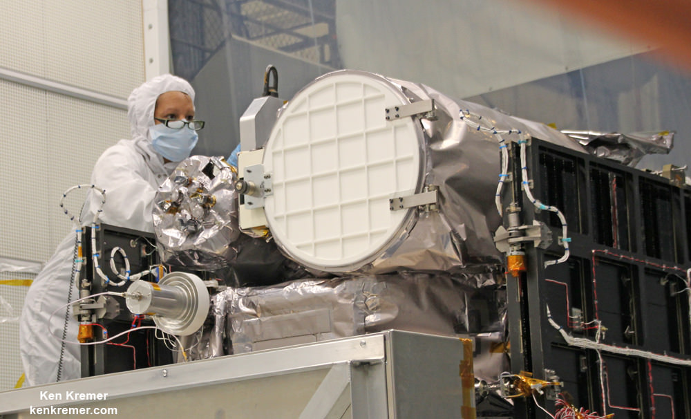
Technician works on NASA Earth science instruments and Earth imaging EPIC camera (white circle) housed on NOAA/NASA Deep Space Climate Observatory (DSCOVR) inside NASA Goddard Space Flight Center clean room in November 2014. Credit: Ken Kremer/kenkremer.com
The couch sized probe was launched atop a SpaceX Falcon 9 on Feb. 11, 2015 from Cape Canaveral, Florida, to start the million mile journey to its deep space observation post at L1. The rocket was funded by the USAF.
The primary goal of the $340 million DSCOVR satellite is to monitor the solar wind and aid very important forecasts of space weather at Earth from L1.
L1 is located 1.5 million kilometers (932,000 miles) sunward from Earth. At L1 the gravity between the sun and Earth is perfectly balanced and the DSCOVR satellite orbits about that spot just like a planet.
The mission is vital because its solar wind observations are crucial to maintaining accurate space weather forecasts to protect US infrastructure such as power grids, aviation, planes in flight, all types of Earth orbiting satellites for civilian and military needs, telecommunications, ISS astronauts and GPS systems.
This animation shows images of the far side of the moon, illuminated by the sun, as it crosses between the DISCOVR spacecraft’s Earth Polychromatic Imaging Camera (EPIC) camera and telescope, and the Earth – one million miles away. Credit: NASA/NOAA
DSCOVR was first proposed in 1998 by then US Vice President Al Gore as the low cost ‘Triana’ satellite to take near continuous views of the Earth’s entire globe to feed to the internet as a means of motivating students to study math and science.
It was also dubbed “Goresat.”
The probe was eventually resurrected and partially rebuilt at NASA Goddard Space Flight Center as a much more capable Earth science satellite that would also conduct the space weather observations.
But Triana was shelved for purely partisan political reasons and the satellite was placed into storage at NASA Goddard.
Thus the practical and teachable science and daily scenes of the gorgeously rotating Earth were lost – until now!
Former VP Al Gore was clearly delighted with today’s launch of NASA’s EPIC website in this pair of tweets:
“Today @NASA launched its site for #DSCOVR’s daily images. I look forward to seeing more from #DSCOVR,” tweeted Al Gore.
“DSCOVR’s site displaying new daily images of Earth from L1 was launched today! Congratulations to all those who made this happen!”
Stay tuned here for Ken’s continuing Earth and planetary science and human spaceflight news.
NOAA/NASA Deep Space Climate Observatory (DSCOVR) undergoes processing in NASA Goddard Space Flight Center clean room. Solar wind instruments at right. DSCOVER launched in February 2015 atop SpaceX Falcon 9 rocket. Credit: Ken Kremer/kenkremer.com
NOAA/NASA/USAF Deep Space Climate Observatory (DSCOVR) undergoes processing in NASA Goddard Space Flight Center clean room. Probe launched in February 2015 atop SpaceX Falcon 9 rocket. Credit: Ken Kremer/kenkremer.com
This animation shows images of the far side of the moon, illuminated by the sun, as it crosses between the DISCOVR spacecraft's Earth Polychromatic Imaging Camera (EPIC) camera and telescope, and the Earth - one million miles away. Credit: NASA/NOAA
This animation shows images of the far side of the moon, illuminated by the sun, as it crosses between the DISCOVR spacecraft’s Earth Polychromatic Imaging Camera (EPIC) camera and telescope, and the Earth – one million miles away. Credit: NASA/NOAA
See YouTube version and EPIC camera below[/caption]
An eye-poppingly ‘EPIC’ view of the sunlit far side of the Moon transiting the sunlit side of Earth was recently captured by NASA’s Earth Polychromatic Imaging Camera (EPIC) camera from one million miles away. “Wow!” – is an understatement!
The stunning animation of the Moon crossing in front of the Earth, shown above, and seemingly unlike anything else, was created from a series of images taken in July by NASA’s EPIC camera flying aboard the orbiting Deep Space Climate Observatory (DSCOVR), a space weather monitoring satellite, according to a NASA statement.
Have just witnessed NASA’s New Horizons flyby of the Pluto-Charondouble planet system, the similarity to what some call the Earth-Moon double planet system is eerie. You could imagine ones heart going out to Earth’s Australian continent as an upside down version of Pluto’s bright heart shaped ‘Tombaugh Regio’ region in the southern hemisphere.
EPIC is a four megapixel CCD camera and telescope mounted on DSCOVR and orbiting at the L1 Lagrange Point – a neutral gravity point that lies on the direct line between Earth and the sun.
The goal of the $340 million DSCOVR is to monitor the solar wind and aid very important forecasts of space weather at Earth from L1.
EPIC will capture “a constant view of the fully illuminated Earth as it rotates, providing scientific observations of ozone, vegetation, cloud height and aerosols in the atmosphere.”
L1 is located 1.5 million kilometers (932,000 miles) sunward from Earth. At L1 the gravity between the sun and Earth is perfectly balanced and the DSCOVR satellite orbits about that spot just like a planet.
The EPIC images “were taken between 3:50 p.m. and 8:45 p.m. EDT on July 16, showing the moon moving over the Pacific Ocean near North America,” NASA said.
This image shows images of the far side of the moon, illuminated by the sun, as it crosses between the DISCOVR spacecraft’s Earth Polychromatic Imaging Camera (EPIC) camera and telescope, and the Earth – one million miles away. Credits: NASA/NOAA
You can see Earth’s North Pole at the upper left side of the images which results from the orbital tilt of Earth from the vantage point of the spacecraft at the L1 Lagrange Point.
EPIC will take full disk color images of the sunlit side of Earth at least six times per day.
They will be made publically available by NASA at a dedicated website, when the camera starts its regular daily science observation campaign of the home planet in about a month during September.
NASA says the images will show varying views of the rotating Earth and they will be posted online some 12 to 36 hours after they are acquired.
Each image is actually a composite of three images taken in the red, green and blue channels of the EPIC camera to provide the final “natural color” image of Earth. Since the images are taken about 30 seconds apart as the moon is moving there is a slight but noticeable artifact on the right side of the moon, NASA explained.
Altogether, “ EPIC takes a series of 10 images using different narrowband spectral filters — from ultraviolet to near infrared — to produce a variety of science products. The red, green and blue channel images are used in these color images.”
EPIC should capture these Earth-Moon transits about twice per year as the orbit of DSCOVR crosses the orbital plane of the moon.
The closest analog according to NASA came in May 2008 when NASA’s Deep Impact spacecraft “captured a similar view of Earth and the moon from a distance of 31 million miles away. The series of images showed the moon passing in front of our home planet when it was only partially illuminated by the sun.”
We never see the far side of the moon from Earth since the bodies are tidally locked. And its quite apparent from the images, that the moon’s far side looks completely different from the side facing Earth. The far side lacks the large, dark, basaltic plains, or maria, that are so prominent on the Earth-facing side.
“It is surprising how much brighter Earth is than the moon,” said Adam Szabo, DSCOVR project scientist at NASA’s Goddard Space Flight Center in Greenbelt, Maryland, in a statement.
“Our planet is a truly brilliant object in dark space compared to the lunar surface.”
DSCOVR is a joint mission between NOAA, NASA, and the U.S Air Force (USAF) that is managed by NOAA. The satellite and science instruments were provided by NASA and NOAA.
Technician works on NASA Earth science instruments and Earth imaging EPIC camera (white circle) housed on NOAA/NASA Deep Space Climate Observatory (DSCOVR) inside NASA Goddard Space Flight Center clean room in November 2014. Credit: Ken Kremer/kenkremer.com
DSCOVR was first proposed in 1998 by then US Vice President Al Gore as the low cost ‘Triana’ satellite to take near continuous views of the Earth’s entire globe to feed to the internet as a means of motivating students to study math and science. It was eventually built as a much more capable Earth science satellite that would also conduct the space weather observations.
But Triana was shelved for purely partisan political reasons and the satellite was placed into storage at NASA Goddard and the science was lost until now.
It was also dubbed “Goresat.’
Stay tuned here for Ken’s continuing Earth and planetary science and human spaceflight news.
Video caption: This animation shows images of the far side of the moon, illuminated by the sun, as it crosses between the DISCOVR spacecraft’s Earth Polychromatic Imaging Camera (EPIC) camera and telescope, and the Earth – one million miles away. Credit: NASA/NOAA
NOAA/NASA Deep Space Climate Observatory (DSCOVR) undergoes processing in NASA Goddard Space Flight Center clean room. Solar wind instruments at right. DSCOVER launched in February 2015 atop SpaceX Falcon 9 rocket. Credit: Ken Kremer/kenkremer.com
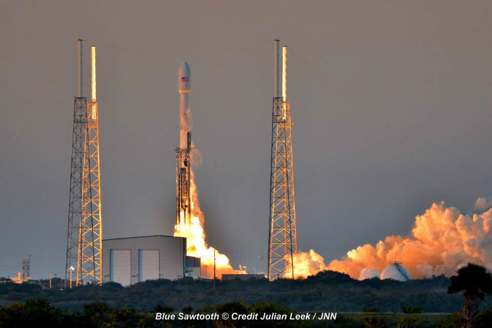
Launch of NOAA DSCOVR satellite from Cape Canaveral Air Force Station on Feb. 11, 2015 to monitor solar storms and space weather. Credit: Julian Leek
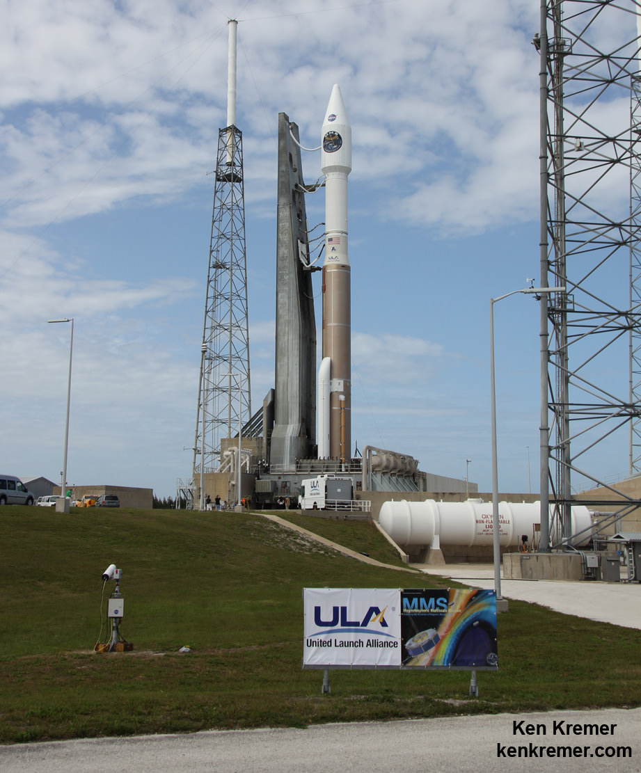
A United Launch Alliance Atlas V 421 rocket is poised for blastoff at Cape Canaveral Air Force Station's Space Launch Complex-41 in preparation for launch of NASA's Magnetospheric Multiscale (MMS) science mission on March 12, 2015. Credit: Ken Kremer- kenkremer.com
KENNEDY SPACE CENTER, FL – A state of the art quartet of identical science satellites aimed at unraveling the mysteries of the process known as magnetic reconnection is slated for a spectacular nighttime blastoff tonight, March 12, atop a United Launch Alliance Atlas V rocket on Cape Canaveral, Florida.
The $1.1 Billion Magnetospheric Multiscale (MMS) mission is comprised of four formation flying and identically instrumented observatories whose objective is providing the first three-dimensional views of a fundamental process in nature known as magnetic reconnection.
Magnetic reconnection is a little understood natural process whereby magnetic fields around Earth connect and disconnect while explosively releasing vast amounts of energy. It occurs throughout the universe.
Liftoff is slated for 10:44 p.m. EDT Thursday March 12 from Space Launch Complex 41 on Cape Canaveral Air Force Station, Florida.
The launch window extends for 30 minutes. You can watch the MMS launch live on NASA TV, below, starting at 8 p.m.
Spectators ringing the Florida space coast region and ranging well beyond should be treated to a magnificent fireworks display and skyward streak of perhaps several minutes – weather and clouds permitting.
Currently the weather forecast is 70 percent “GO” for favorable conditions at launch time. The primary concerns for a safe and successful launch are for cumulus clouds and thick clouds.
In the event of a 24 hour delay for any reason the weather forecast is 60 percent “GO.”
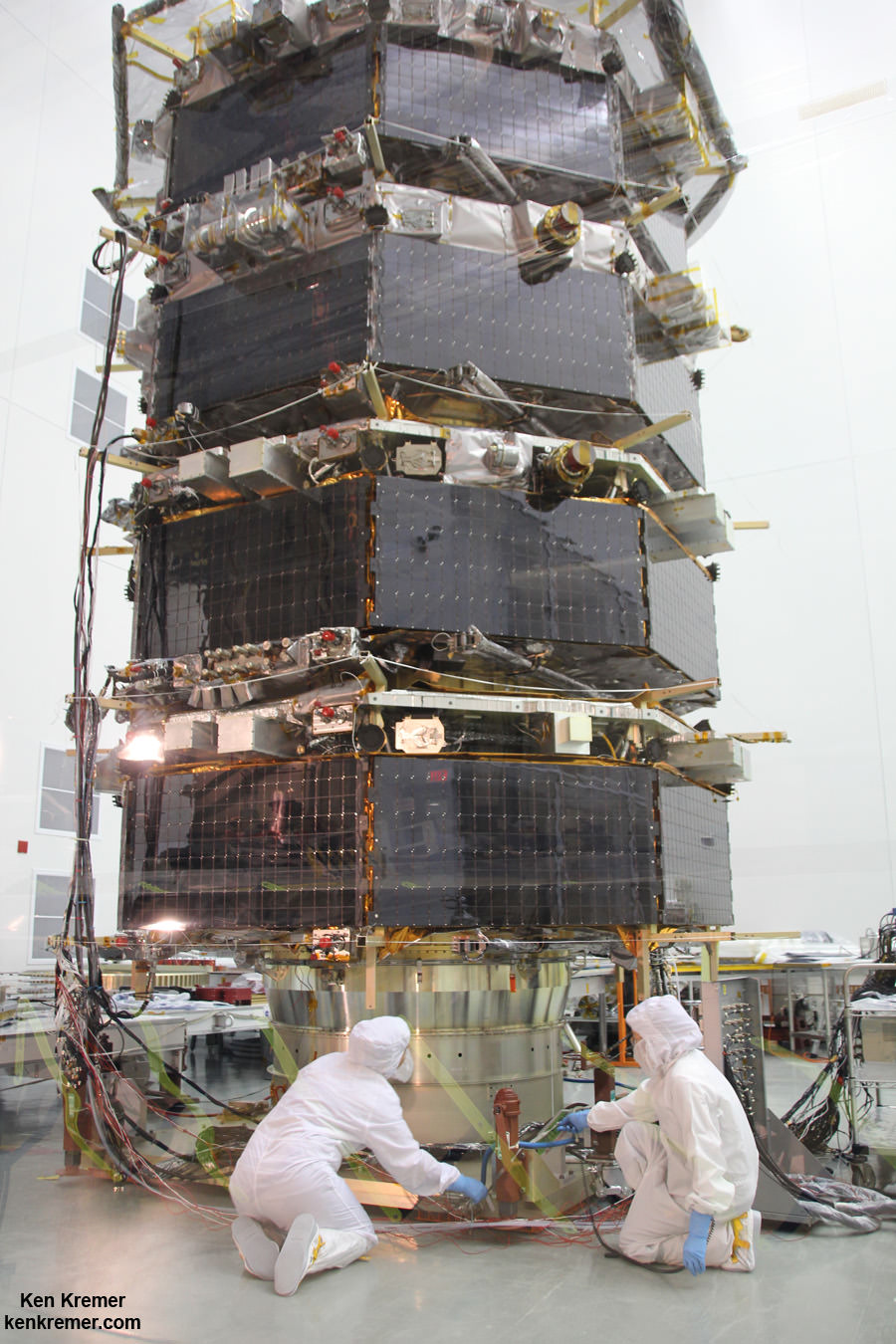
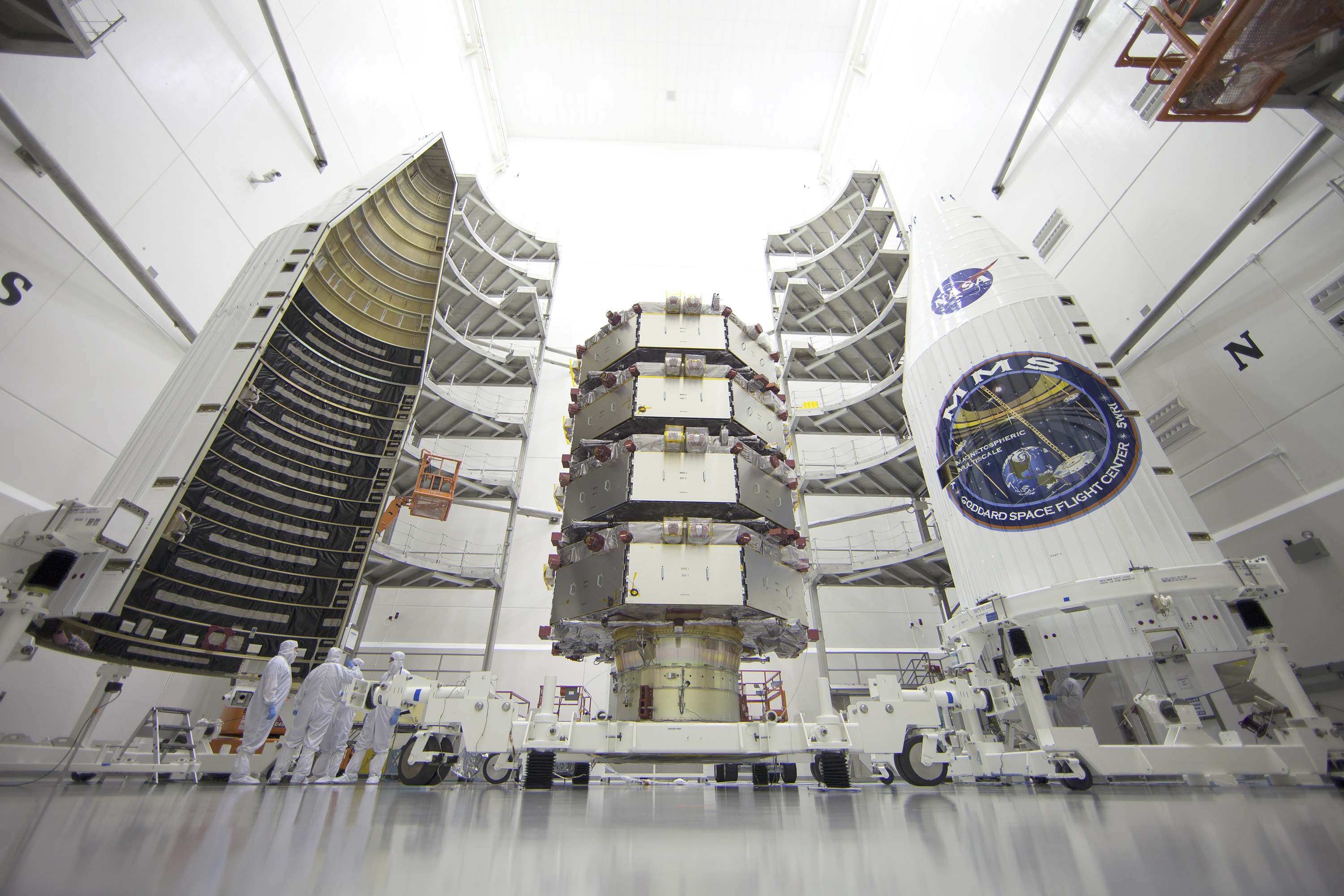
Technicians work on NASA’s 20-foot-tall Magnetospheric Multiscale (MMS) mated quartet of stacked observatories in the cleanroom at NASA’s Goddard Space Flight Center in Greenbelt, Md., on May 12, 2014. Credit: Ken Kremer- kenkremer.com
The 195 foot tall rocket and encapsulated MMS satellite payload were rolled out to Space Launch Complex-41 on Wednesday March 10 at 10 a.m. on the Mobile Launch Platform (MLP) about 1800 feet from the Vertical Integration Facility or VIF to the Cape Canaveral pad.
The two stage Atlas V rocket will deliver the MMS constellation to a highly elliptical orbit.
The venerable rocket with a 100% success rate will launch in the Atlas V 421 configuration with a 4-meter diameter Extra Extended Payload Fairing along with two Aerojet Rocketdyne solid rocket motors attached to the Atlas booster first stage.
A United Launch Alliance Atlas V 421 rocket is poised for blastoff at Cape Canaveral Air Force Station’s Space Launch Complex-41 in preparation for launch of NASA’s Magnetospheric Multiscale (MMS) science mission on March 12, 2015. Credit: Ken Kremer- kenkremer.com
The Atlas first stage is powered by the RD AMROSS RD-180 engine and the Centaur upper stage is powered by the Aerojet Rocketdyne RL10A engine producing 22,300 lb of thrust.
The first stage is 12.5 ft in diameter and fueled with liquid propellants. The RD-180 burns RP-1 highly purified kerosene and liquid oxygen and delivers 860,200 lb of sea level thrust.
This is ULA’s 4th launch in 2015, the 53nd Atlas V mission and the fourth Atlas V 421 launch.
“This is the perfect time for this mission,” said Jim Burch, principal investigator of the MMS instrument suite science team at Southwest Research Institute (SwRI) in San Antonio, Texas.
“MMS is a crucial next step in advancing the science of magnetic reconnection. Studying magnetic reconnection near Earth will unlock the ability to understand how this process works throughout the entire universe.”
After a six month check out phase the probes will start science operation in September.
Unlike previous missions to observe the evidence of magnetic reconnection events, MMS will have sufficient resolution to measure the characteristics of ongoing reconnection events as they occur.
The four probes were built in-house by NASA at the agency’s Goddard Space Flight Center in Greenbelt, Maryland where I visited them during an inspection tour by NASA Administrator Charles Bolden.
I asked Bolden to explain the goals of MMS during a one-on-one interview.
“MMS will help us study the phenomena known as magnetic reconnection and help us understand how energy from the sun – magnetic and otherwise – affects our own life here on Earth,” Bolden told Universe Today.
“MMS will study what effects that process … and how the magnetosphere protects Earth.”
MMS measurements should lead to significant improvements in models for yielding better predictions of space weather and thereby the resulting impacts for life here on Earth as well as for humans aboard the ISS and robotic satellite explorers in orbit and the heavens beyond.
The best place to study magnetic reconnection is ‘in situ’ in Earth’s magnetosphere. This will lead to better predictions of space weather phenomena.
Magnetic reconnection is also believed to help trigger the spectacular aurora known as the Northern or Southern lights.
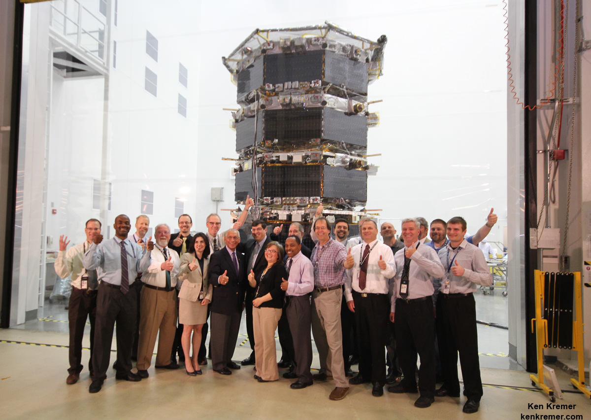
NASA Administrator Charles Bolden poses with the agency’s Magnetospheric Multiscale (MMS) spacecraft, mission personnel, Goddard Center Director Chris Scolese and NASA Associate Administrator John Grunsfeld, during visit to the cleanroom at NASA’s Goddard Space Flight Center in Greenbelt, Md., on May 12, 2014. Credit: Ken Kremer- kenkremer.com
MMS is a Solar Terrestrial Probes Program, or STP, mission within NASA’s Heliophysics Division
Watch for Ken’s ongoing MMS coverage and he’ll be onsite at the Kennedy Space Center in the days leading up to the launch on March 12.
Stay tuned here for Ken’s continuing MMS, Earth and planetary science and human spaceflight news.
Technicians work on NASA’s 20-foot-tall Magnetospheric Multiscale (MMS) mated quartet of stacked observatories in the cleanroom at NASA's Goddard Space Flight Center in Greenbelt, Md., on May 12, 2014. Credit: Ken Kremer- kenkremer.com
NASA’s first mission dedicated to study the process in nature known as magnetic reconnection undergoing final preparation for launch from Cape Canaveral, Florida in just under two weeks time.
The Magnetospheric Multiscale (MMS) mission is comprised of a quartet of identically instrumented observatories aimed at providing the first three-dimensional views of a fundamental process in nature known as magnetic reconnection.
Magnetic reconnection is the process whereby magnetic fields around Earth connect and disconnect while explosively releasing vast amounts of energy. It occurs throughout the universe.
“Magnetic reconnection is one of the most important drivers of space weather events,” said Jeff Newmark, interim director of the Heliophysics Division at NASA Headquarters in Washington.
“Eruptive solar flares, coronal mass ejections, and geomagnetic storms all involve the release, through reconnection, of energy stored in magnetic fields. Space weather events can affect modern technological systems such as communications networks, GPS navigation, and electrical power grids.”
The four MMS have been stacked on top of one another like pancakes, encapsulated in the payload fairing, transported to the launch pad, hoisted and mated to the top of the 195-foot-tall rocket.
NASA’s Magnetospheric Multiscale (MMS) observatories are shown here in the clean room being processed for a March 12, 2015 launch from Space Launch Complex 41 on Cape Canaveral Air Force Station, Florida. Credit: NASA/Ben Smegelsky
The nighttime launch of MMS on a United Launch Alliance Atlas V rocket should put on a spectacular sky show for local spectators along the Florida space coast as well as more distant located arcing out in all directions.
Liftoff is slated for 10:44 p.m. EDT Thursday March 12 from Space Launch Complex 41 on Cape Canaveral Air Force Station, Florida.
The launch window extends for 30 minutes.
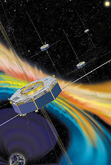
Artist rendition of the four MMS spacecraft in orbit in Earth’s magnetic field. Credit: NASA
After a six month check out phase the probes will start science operation in September.
Unlike previous missions to observe the evidence of magnetic reconnection events, MMS will have sufficient resolution to measure the characteristics of ongoing reconnection events as they occur.
The four probes were built in-house by NASA at the agency’s Goddard Space Flight Center in Greenbelt, Maryland where is visited them during an inspection tour by NASA Administrator Charles Bolden.
I asked Bolden to explain the goals of MMS during a one-on-one interview.
“MMS will help us study the phenomena known as magnetic reconnection and help us understand how energy from the sun – magnetic and otherwise – affects our own life here on Earth,” Bolden told Universe Today.
“MMS will study what effects that process … and how the magnetosphere protects Earth.”
MMS measurements should lead to significant improvements in models for yielding better predictions of space weather and thereby the resulting impacts for life here on Earth as well as for humans aboard the ISS and robotic satellite explorers in orbit and the heavens beyond.
NASA Administrator Charles Bolden poses with the agency’s Magnetospheric Multiscale (MMS) spacecraft, mission personnel, Goddard Center Director Chris Scolese and NASA Associate Administrator John Grunsfeld, during visit to the cleanroom at NASA’s Goddard Space Flight Center in Greenbelt, Md., on May 12, 2014. Credit: Ken Kremer- kenkremer.com
The best place to study magnetic reconnection is ‘in situ’ in Earth’s magnetosphere. This will lead to better predictions of space weather phenomena.
“This is the perfect time for this mission,” said Jim Burch, principal investigator of the MMS instrument suite science team at Southwest Research Institute (SwRI) in San Antonio, Texas.
“MMS is a crucial next step in advancing the science of magnetic reconnection. Studying magnetic reconnection near Earth will unlock the ability to understand how this process works throughout the entire universe.”
Magnetic reconnection is also believed to help trigger the spectacular aurora known as the Northern or Southern lights.
MMS is a Solar Terrestrial Probes Program, or STP, mission within NASA’s Heliophysics Division.
Watch for Ken’s ongoing MMS coverage and he’ll be onsite at the Kennedy Space Center in the days leading up to the launch on March 12.
Stay tuned here for Ken’s continuing MMS, Earth and planetary science and human spaceflight news.
Ken Kremer
………….
Learn more about MMS, Mars rovers, Orion, SpaceX, Antares, NASA missions and more at Ken’s upcoming outreach events:
Mar 6: “MMS Update, Future of NASA Human Spaceflight, Curiosity on Mars,” Delaware Valley Astronomers Assoc (DVAA), Radnor, PA, 7 PM.
Mar 10-12: “MMS, Orion, SpaceX, Antares, Curiosity Explores Mars,” Kennedy Space Center Quality Inn, Titusville, FL, evenings
DSCOVR mission logo. Credit: NOAA/NASA/U.S. Air Force
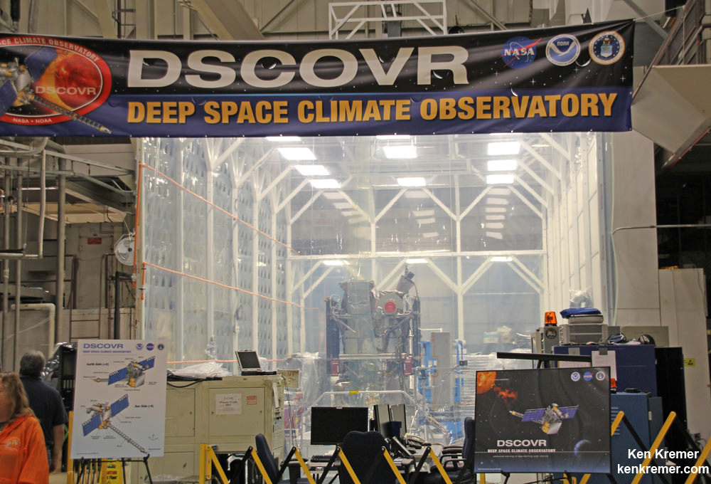
The long awaited Deep Space Climate Observatory, or DSCOVR science satellite is slated to blast off atop a SpaceX Falcon 9 on Sunday, Feb. 8, from Cape Canaveral, Florida on a mission to monitor the solar wind and aid very important forecasts of space weather at Earth.
DSCOVR is a joint mission between NOAA, NASA, and the U.S Air Force (USAF) that will be managed by NOAA. The satellite and science instruments are provided by NASA and NOAA.
Update Feb 8: Hold, Hold, Hold !!! 6:10 PM 2/8/15 Terminal Count aborted at T Minus 2 min 26 sec due to a tracking issue. NO launch of Falcon 9 today. rocket being safed now. next launch opportunity is Monday. Still TBD.
The rocket is provided by the USAF. SpaceX will try to recover the first stage via a guided descent to a floating barge in the Atlantic Ocean.
The weather outlook is currently very promising with a greater than 90 percent chance of favorable weather at launch time shortly after sunset on Sunday which could make for a spectacular viewing opportunity for spectators surrounding the Florida Space coast.
Liftoff atop the SpaceX Falcon 9 rocket is targeted for at 6:10:12 p.m. EST on Feb. 8, from Cape Canaveral Air Force Station Space Launch Complex 40.
There is an instantaneous launch window, meaning that any launch delay due to weather, technical or other factors will force a scrub to Monday.
The launch will be broadcast live on NASA TV: http://www.nasa.gov/nasatv
NASA’s DSCOVR launch blog coverage of countdown and liftoff will begin at 3:30 p.m. Sunday.
NOAA/NASA Deep Space Climate Observatory (DSCOVR) undergoes processing in NASA Goddard Space Flight Center clean room. Solar wind instruments at right. DSCOVER will launch in February 2015 atop SpaceX Falcon 9 rocket. Credit: Ken Kremer/kenkremer.com/AmericaSpace
“DSCOVR is NOAA’s first operational space weather mission to deep space,” said Stephen Volz, assistant administrator of the NOAA Satellite and Information Service in Silver Spring, Maryland, at the pre-launch briefing today (Feb. 7) at the Kennedy Space Center in Florida.
The mission of DSCOVR is vital because its solar wind observations are crucial to maintaining accurate space weather forecasts to protect US infrastructure from disruption by approaching solar storms.
“DSCOVR will maintain the nation’s solar wind observations, which are critical to the accuracy and lead time of NOAA’s space weather alerts, forecasts, and warnings,” according to a NASA description.
“Space weather events like geomagnetic storms caused by changes in solar wind can affect public infrastructure systems, including power grids, telecommunications systems, and aircraft avionics.”
DSCOVR will replace NASA’s aging Advanced Composition Explorer (ACE) satellite which is nearly 20 years old and far beyond its original design lifetime.
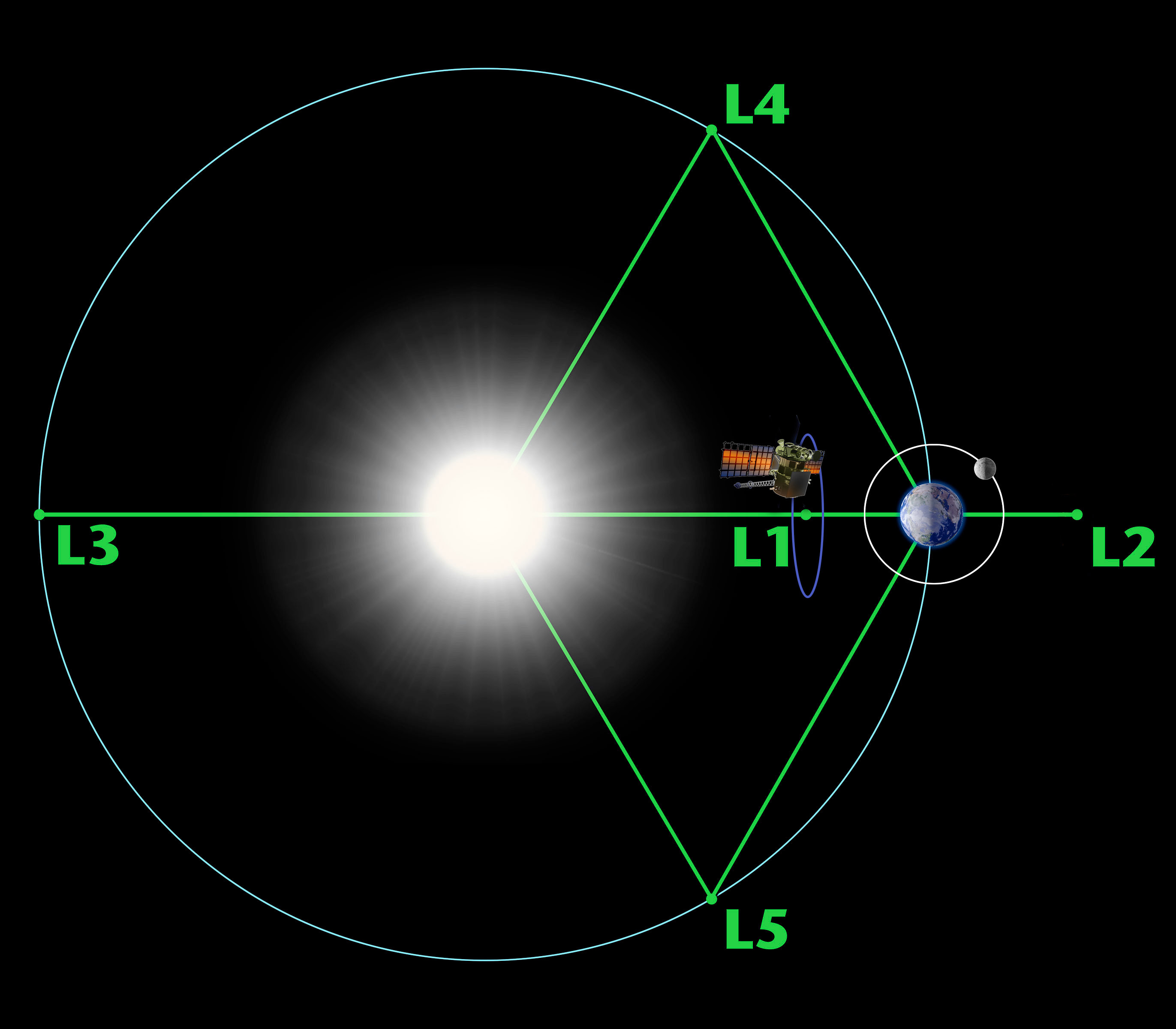
The couch sized probe is being targeted to the L1 Lagrange Point, a neutral gravity point that lies on the direct line between Earth and the sun located 1.5 million kilometers (932,000 miles) sunward from Earth. At L1 the gravity between the sun and Earth is perfectly balanced and the satellite will orbit about that spot just like a planet.
L1 is a perfect place for the science because it lies outside Earth’s magnetic environment. The probe will measure the constant stream of solar wind particles from the sun as they pass by.
Diagram of the five Lagrange points associated with the sun-Earth system, showing DSCOVR orbiting the L-1 point. Image is not to scale. Credit: NASA/WMAP Science Team
This will enable forecasters to give a 15 to 60 minute warning of approaching geomagnetic storms that could damage valuable infrastructure.
DSCOVR is equipped with a suite of four continuously operating solar science and Earth science instruments from NASA and NOAA.
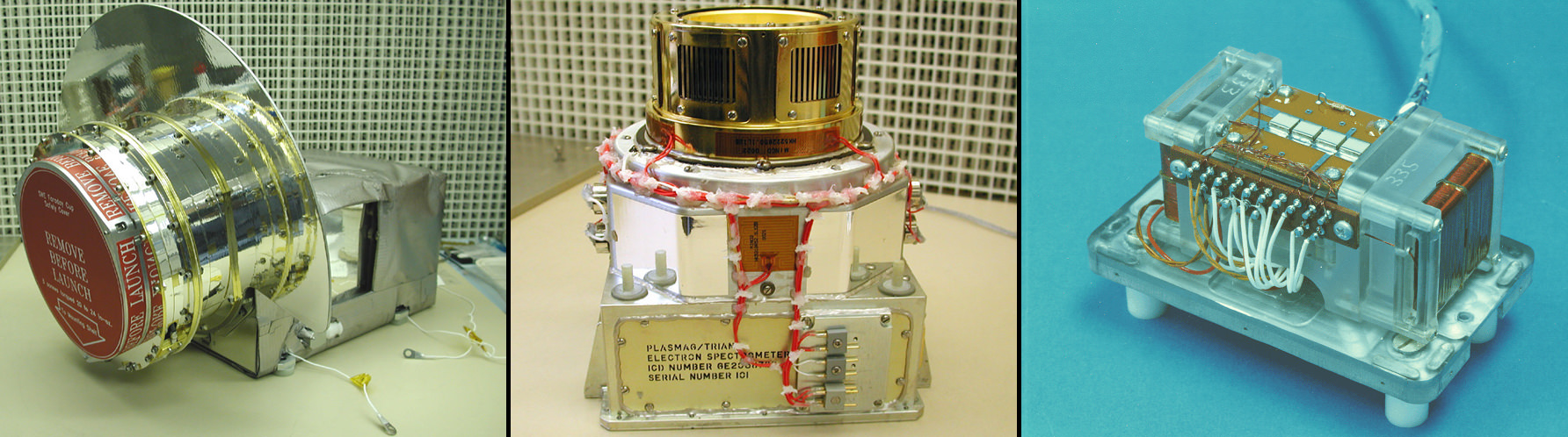
It will make simultaneous scientific observations of the solar wind and the entire sunlit side of Earth. Three instruments will help measure the solar wind on the DSCOVR mission: (shown from left to right), the Faraday cup to monitor the speed and direction of positively-charged solar wind particles, the electron spectrometer to monitor electrons, and a magnetometer to measure magnetic fields. Credit: NASA/DSCOVR
The 750-kilogram DSCOVR probe measures 54 inches by 72 inches.
I saw the DSCOVR spacecraft up close at NASA Goddard Space Flight Center in Maryland last fall during processing in the clean room.
NOAA/NASA/USAF Deep Space Climate Observatory (DSCOVR) undergoes processing in NASA Goddard Space Flight Center clean room. Probe will launch in February atop SpaceX Falcon 9 rocket. Credit: Ken Kremer – kenkremer.com
A secondary objective of the rocket launch for SpaceX is to conduct their second attempt to recover the Falcon 9 first stage booster on an ocean going barge. Read my articles about the first attempt in January 2015, starting here.
It was originally named ‘Triana’ (aka Goresat) and was conceived by then US Vice President Al Gore as a low cost satellite to take near continuous views of the Earth’s entire globe to feed to the internet as a means of motivating students to study math and science. It was eventually built as a much more capable Earth science satellite as well as to conduct the space weather observations.
But Triana was shelved for purely partisan political reasons and the satellite was placed into storage and the science was lost until now.
Stay tuned here for Ken’s continuing Earth and planetary science and human spaceflight news.
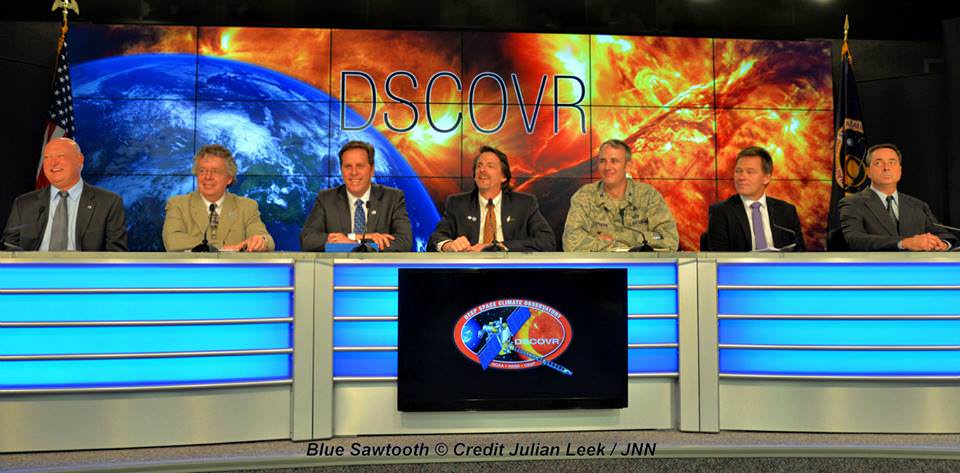
The team is ready for the launch of NASA’s DSCOVR spacecraft aboard a SpaceX Falcon 9 rocket. L/R Mike Curie KSC NASA News Chief, Stephen Volz, assistant administrator NOAA, Tom Berger, director of NOAA Space Weather Prediction Center Boulder Colorado,Steven Clark, NASA Joint Agency Satellite Division, Col. D. Jason Cothern, Space Demonstration Division chief at Kirkland AFB NM. Hans Koenigsmann, VP of mission assurance at SpaceX in Hawthorne, California, Mike McAlaneen, launch weather officer 45th Space wing Cape Canaveral Air Force Station, Florida. Credit: Julian Leek