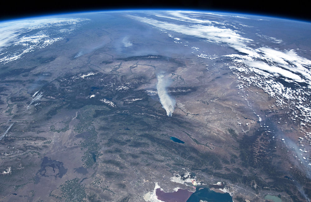
Wildfires continue to rage across the western United States, burning forests and property alike, and even the most remote have sent up enormous plumes of smoke that are plainly visible to astronauts aboard the Space Station.
The photo above was taken by an Expedition 31 crew member on June 27, showing thick smoke drifting northeast from the Fontenelle fire currently burning in Wyoming. More plumes can be seen to the north.
Utah’s Great Salt Lake can be seen at the bottom right of the image. Its two-tone coloration is due to different species of algae that live in the lake, which is split by the physical barrier of a railroad causeway.
You can watch a video of the wildfires in the west taken from the ISS here, and see more “fire and smoke” news and images from space here.
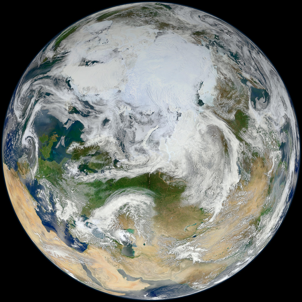
This latest portrait of Earth from NASA’s Suomi NPP satellite puts the icy Arctic in the center, showing the ice and clouds that cover our planet’s northern pole. The image you see here was created from data acquired during fifteen orbits of Earth.
In January of this year Suomi NPP images of Earth were used to create an amazing “Blue Marble” image that spread like wildfire across the internet, becoming one of the latest “definitive” images of our planet. Subsequent images have been released by the team at Goddard Space Flight Center, each revealing a different perspective of Earth.
NASA launched the National Polar-orbiting Operational Environmental Satellite System Preparatory Project (or NPP) on October 28, 2011 from Vandenberg Air Force Base. On Jan. 24, NPP was renamed Suomi National Polar-orbiting Partnership, or Suomi NPP, in honor of the late Verner E. Suomi. It’s the first satellite designed to collect data to improve short-term weather forecasts and increase understanding of long-term climate change.
Suomi NPP orbits the Earth about 14 times each day and observes nearly the entire surface of the planet.
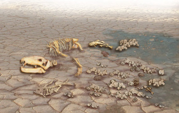
Based on fossil records, 250 million years ago over 90% of all species on Earth died out, effectively resetting evolution. (Image: Lunar and Planetary Institute)
[/caption]
Hey, remember that one time when 90% of all life on Earth got wiped out?
I don’t either. But it’s a good thing it happened because otherwise none of us would be here to… not remember it. Still, the end-Permian Extinction — a.k.a. the Great Dying — was very much a real crisis for life on Earth 252 million years ago. It makes the K-T extinction event of the dinosaurs look like a rather nice day by comparison, and is literally the most catastrophic event known to have ever befallen Earthly life. Luckily for us (and pretty much all of the species that have arisen since) the situation eventually sorted itself out. But how long did that take?
An alien Earth: what our planet looked like during the time of the Permian Extinction. (Via The Planetary Habitability Laboratory @ UPR Arecibo, NASA, Ron Blakey and Colorado Plateau Geosystems, Inc., and The PaleoMap Project)
The Permian Extinction was a perfect storm of geological events that resulted in the disappearance of over 90% of life on Earth — both on land and in the oceans. (Or ocean, as I should say, since at that time the land mass of Earth had gathered into one enormous continent — called Pangaea — and thus there was one ocean, referred to as Panthalassa.) A combination of increased volcanism, global warming, acid rain, ocean acidification and anoxia, and the loss of shallow sea habitats (due to the single large continent) set up a series of extinctions that nearly wiped our planet’s biological slate clean.
Exactly why the event occurred and how Earth returned to a state in which live could once again thrive is still debated by scientists, but it’s now been estimated that the recovery process took about 10 million years.
Research by Dr. Zhong-Qiang Chen from the China University of Geosciences in Wuhan, and Professor Michael Benton from the University of Bristol, UK, show that repeated setbacks in conditions on Earth continued for 5 to 6 million years after the initial wave of extinctions. It appears that every time life would begin to recover within an ecological niche, another wave of environmental calamities would break.
“Life seemed to be getting back to normal when another crisis hit and set it back again,” said Prof. Benton. “The carbon crises were repeated many times, and then finally conditions became normal again after five million years or so.”
“The causes of the killing – global warming, acid rain, ocean acidification – sound eerily familiar to us today. Perhaps we can learn something from these ancient events.”
– Michael Benton, Professor of Vertebrate Palaeontology at the University of Bristol
It wasn’t until the severity of the crises abated that life could gradually begin reclaiming and rebuilding Earth’s ecosystems. New forms of life appeared, taking advantage of open niches to grab a foothold in a new world. It was then that many of the ecosystems we see today made their start, and opened the door for the rise of Earth’s most famous prehistoric critters: the dinosaurs.
“The event had re-set evolution,” said Benton. “However, the causes of the killing – global warming, acid rain, ocean acidification – sound eerily familiar to us today. Perhaps we can learn something from these ancient events.”
The team’s research was published in the May 27 issue of Nature Geoscience. Read more on the University of Bristol’s website here.
Ever since the infamous 2006 reclassification of Pluto off the list of “official” planets (which had a rather incendiary effect on many of the distant world’s Earthly fans) the term “planet” has been seen by some as a variable one, difficult to define and apparently able to be given and taken away. But was Pluto ever really deserving of the title to begin with?
This fun info-animation by C.G.P. Grey suggests that it wasn’t, and offers a compelling explanation why.
“To my constant surprise the issue of Pluto’s planetary status — which I think should be a dry technical issue — really gets people riled. But it’s also been my experience that the people who most want Pluto to be a planet know the least about it and the history of its discovery. So, I hope that this video can help correct that a little bit.”
We still love you, Pluto, no matter what you are!
See more of Grey’s excellent animations on YouTube here.
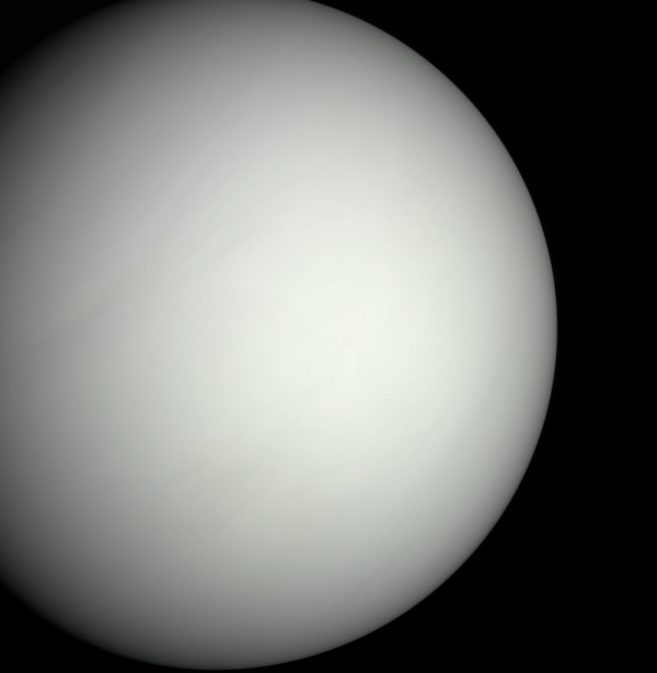
The featureless face of Venus, as seen by MESSENGER (NASA/Gordan Ugarkovic)
[/caption]
With Venus about to get its day in the Sun — very much literally — the European Space Agency has assembled an excellent video about our planetary neighbor.
Watch the video below:
Once thought to be similar to Earth, possibly even having liquid water and plant life on its surface, Venus has since been discovered to be anything but hospitable to life. Beneath its cream-colored clouds lies a hellish hothouse of searing temperatures and crushing pressure, making attempts at exploration difficult at best. But ESA’s Venus Express, currently in orbit around the planet, has helped scientists learn more about Venus than ever before, opening our eyes to what really lies beneath — and within — its opaque atmosphere.
Venus is still a planet shrouded in mystery (and sulfuric acid clouds!) but we are gradually pulling away the veil.
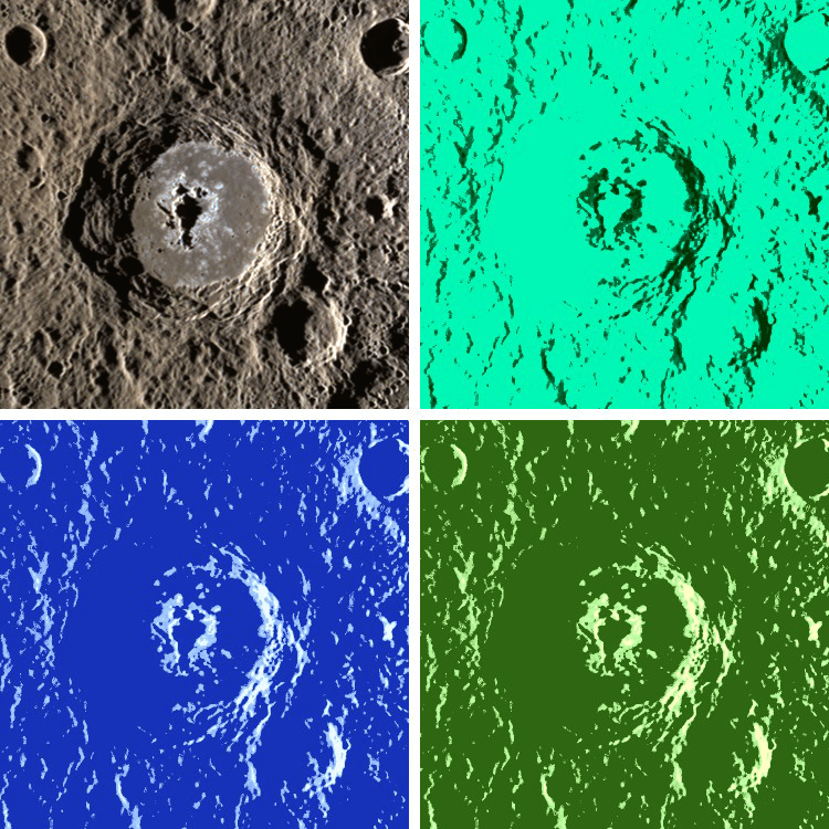
Warhol crater, one of 23 recently named craters on Mercury
[/caption]
As pop art icon Andy Warhol said, “In the future everyone will be famous for fifteen minutes,” and so here’s an image of the crater on Mercury that now bears his name, set up in the style of one of his multicolored silkscreens.
Warhol is one of 23 craters on Mercury to be recently approved for names by the International Astronomical Union (IAU), joining other notable artists, authors and musicians like Gustav Holst, Rene Magritte and Dr. Seuss who now have craters named in their honor on the first rock from the Sun.
95 km (59 miles) in diameter, Warhol crater features a large, elongated central peak, stepped walls and many of the curious erosions known as hollows.
The original image, seen at top left, was acquired by NASA’s MESSENGER spacecraft on October 21, 2011, using its Wide-Angle Camera Mercury Dual Imaging System (MDIS) instrument.
With the new list of 23 named craters, there are now 76 officially (and artistically) titled craters on Mercury since MESSENGER’s first pass of the planet in January 2008.
See the original release by the MESSENGER mission team here.
“I’m bored with that line. I never use it anymore. My new line is “In 15 minutes everybody will be famous.”
– Andy Warhol (1928 – 1987)
Image credit: NASA/Johns Hopkins University Applied Physics Laboratory/Carnegie Institution of Washington
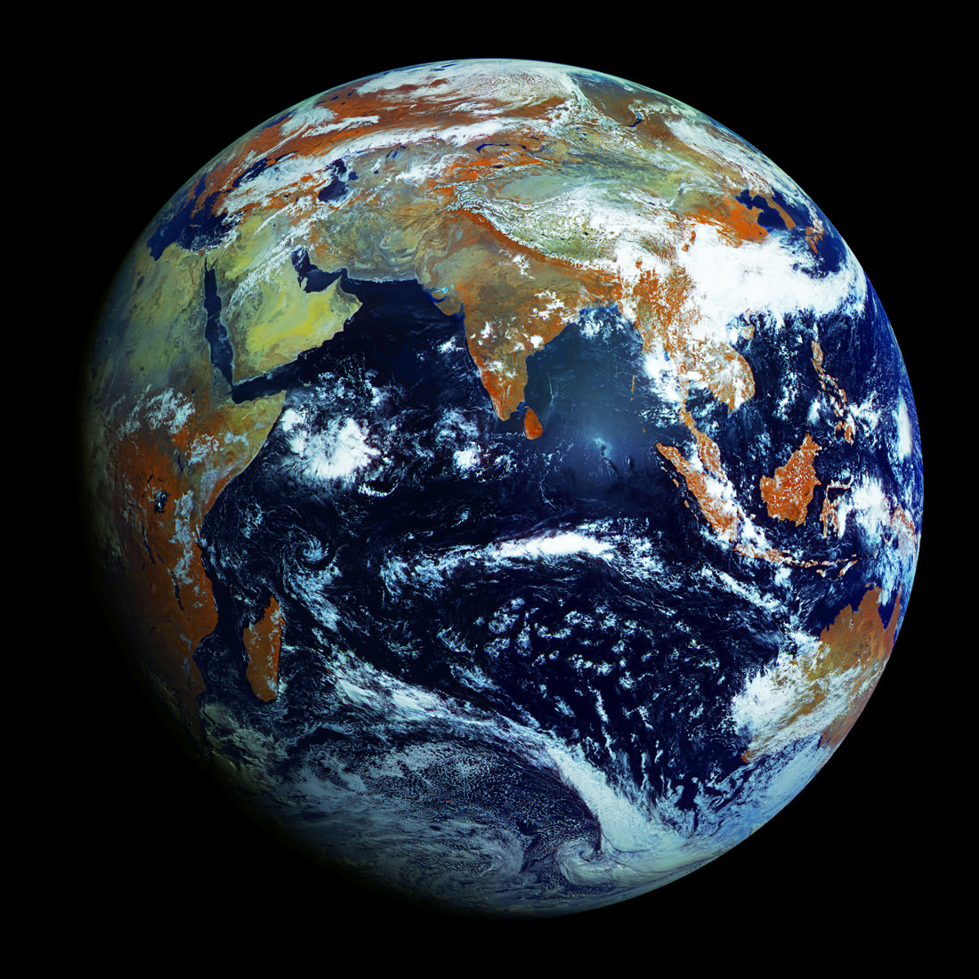
Full-disk image of Earth from Russia's Elektro-L satellite. (NTs OMZ)
[/caption]
Unlike most satellite images of Earth, this one was not assembled from multiple swath scans or digitally projected onto a globe model — it’s the full disk of our planet in captured as a single, enormous 121 megapixel image, acquired by Russia’s Elektro-L weather-forecasting satellite.
Like NASA’s GOES satellites, Elektro-L is parked in a geostationary orbit approximately 36,000 km (22,300 miles) above our planet. Unlike NASA’s satellites, however, Elektro-L captures images in near-infrared as well as visible wavelengths, providing detail about not only cloud movement but also vegetation variations. Its wide-angle Multichannel Scanning Unit (MSU) takes images every 15-30 minutes, showing the same viewpoint of Earth across progressive times of the day.
At a resolution of 0.62 miles per pixel, full-size Elektro-L images are some of the most detailed images of Earth acquired by a weather satellite.
Download the full-size image here (100+ megabytes).
Launched aboard a Zenit rocket on January 20, 2011, Elektro-L was the first major spacecraft to be developed in post-Soviet Russia. Parked over Earth at 76 degrees east longitude, Elektro-L provides local and global weather forecasting and analysis of ocean conditions, as well as “space weather” monitoring — measurements of solar radiation and how it interacts with Earth’s magnetic field. Its initial lifespan is projected to be ten years.
A second Elektro-L satellite is anticipated to launch in 2013.
Image credit: Russian Federal Space Agency / Research Center for Earth Operative Monitoring (NTS OMZ). See more images and video from Elektro-L on James Drake’s Planet Earth here. (Tip of the geostationary hat to Jesus Diaz at Gizmodo.)
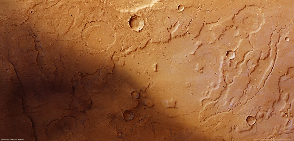
The transition between Acidalia Planitia and Tempe Terra from the Mars Express High-Resolution Stereo Camera (HRSC). Credit ESA/DLR/FU Berlin (G. Neukum)
[/caption]
ESA’s Mars Express orbiter has sent back images revealing terrain that seems to have been sculpted by flowing water, lending further support to the hypothesis that Mars had liquid water on its surface at some point.
The region seen above in a HRSC image is along the border of the Acidalia Planitia region, a vast, dark swath of Mars’ northern hemisphere so large that it’s visible from Earth.
In 1877 the Italian astronomer Giovanni Schiaparelli named the region after a mythical fountain, where the three Graces of Greek mythology were said to have bathed.
Although there may not be any fountains or ancient Immortals within Acidalia Planitia, there may have been water — enough to carve serpentine channels and steep scallops along the edges of wide valleys, much in the same way that the Grand Canyon was carved by the Colorado River.
In the HRSC image some of the etched valleys extend outwards from craters, implying that they were created by water emptying out from within the craters. In addition, sediments present within older craters indicate that they were once filled with water, likely for an extended time.
Acidalia Planitia in a broader context. (NASA MGS MOLA Science Team)
With images like these, so reminiscent of similar features found here on Earth, it’s hard to discount that Mars once had liquid water upon its surface; perhaps some of it still remains today in pockets beneath the ground!
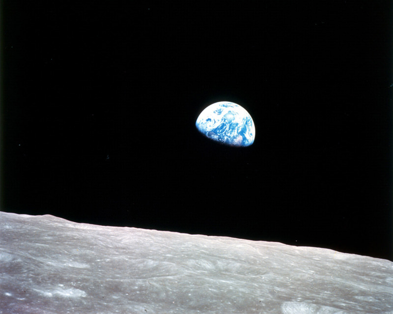
The first color photo of Earth taken from orbit around the Moon. (NASA)
On December 24, 1968, Apollo 8 astronauts Frank Borman, William Anders and Jim Lovell were the first humans to witness an Earthrise as our home planet came up over the lunar horizon. The photos they captured were the first of their kind, instantly inspiring the imaginations of millions and highlighting the beauty and fragility of our world.
Now, NASA has used modern satellite data to recreate the scenes that the Apollo 8 astronauts saw 44 years ago and combined them with their historic photographs to present a new “Earthrise”… version 2.0.
Created in recognition of Earth Day 2012, the Earthrise animation was made from data acquired by NASA’s Lunar Reconnaissance Orbiter’s laser altimeter, as well as the Moderate Resolution Imaging Spectroradiometer (MODIS) on the Terra Earth-observing satellite.
“This visualization recreates for everyone the wondrous experience of seeing Earth from that privileged viewpoint,” says LRO Project Scientist Rich Vondrak of NASA’s Goddard Space Flight Center.
Animator Ernie Wright recreated the scene using Apollo mission reports and photos taken by the crew. The audio is a recording of original communication from the astronauts.
[/caption]
“I think the one overwhelming emotion that we had was when we saw the earth rising in the distance over the lunar landscape… it makes us realize that we all do exist on one small globe. For from 230,000 miles away it really is a small planet.”
MESSENGER image of Mercury, acquired with its Wide Angle Camera on March 21, 2012.
[/caption]
The subtle yet surprisingly varied colors of Mercury are revealed in the latest images from NASA’s MESSENGER spacecraft, now in its extended mission and second year in orbit.
The image above, a composite of Wide Angle Camera images acquired in 996, 748 and 433 nanometers for red, green and blue, shows a semi-lit limb of Mercury with the bright rayed crater Debussy visible at left. (The image has been rotated 180 degrees from the original, and color saturation was boosted by 25%.)
Named for the French composer Claude Debussy of “Claire de Lune” fame, the crater itself is approximately 50 miles (80 km) wide. It was first detected by ground-based radar telescopes in 1969 as a bright spot.
Now, 43 years later, we have a spacecraft in orbit sending back images like this. Amazing.
The various colors seen across Mercury are due to different mineral compositions of the geologic regions. The exact compositions are not yet known, and the current puzzle that researchers are trying to solve with MESSENGER is to figure out what materials make up Mercury’s complex, multi-hued surface. That will also give a clue as to what’s inside the planet and how it evolved… as well as how it is currently evolving today.
The image below is from MESSENGER’s Visual and Infrared Spectrograph (VIRS) and shows a map of Mercury’s surface, with RGB colors corresponding to different mineralogical compositions.
Sinusoidal equal area projection map of Mercury from MESSENGER's VIRS instrument.
Younger surface materials that are brighter at visible wavelengths and less affected by space weathering show up in reds, yellows and greens. Materials that may have relatively higher iron contents show up in blue.
These are Mercury’s “other colors”… maybe not what we would see with our own eyes, but beautiful nonetheless to planetary scientists!
See the above image on the MESSENGER website here.
Image credit: NASA/Johns Hopkins University Applied Physics Laboratory/Carnegie Institution of Washington