
[/caption]
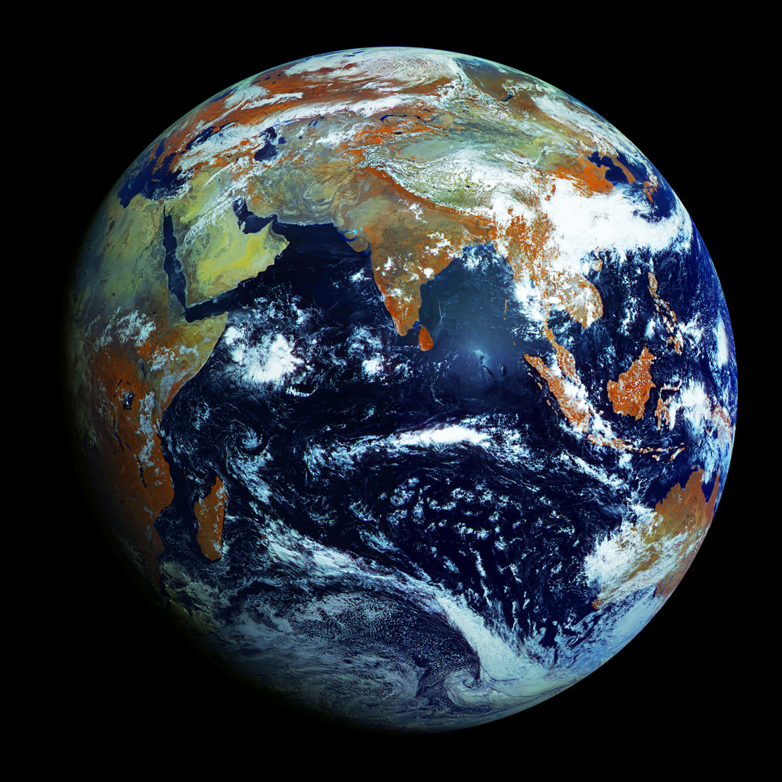
Unlike most satellite images of Earth, this one was not assembled from multiple swath scans or digitally projected onto a globe model — it’s the full disk of our planet in captured as a single, enormous 121 megapixel image, acquired by Russia’s Elektro-L weather-forecasting satellite.
Like NASA’s GOES satellites, Elektro-L is parked in a geostationary orbit approximately 36,000 km (22,300 miles) above our planet. Unlike NASA’s satellites, however, Elektro-L captures images in near-infrared as well as visible wavelengths, providing detail about not only cloud movement but also vegetation variations. Its wide-angle Multichannel Scanning Unit (MSU) takes images every 15-30 minutes, showing the same viewpoint of Earth across progressive times of the day.
At a resolution of 0.62 miles per pixel, full-size Elektro-L images are some of the most detailed images of Earth acquired by a weather satellite.
Download the full-size image here (100+ megabytes).

Launched aboard a Zenit rocket on January 20, 2011, Elektro-L was the first major spacecraft to be developed in post-Soviet Russia. Parked over Earth at 76 degrees east longitude, Elektro-L provides local and global weather forecasting and analysis of ocean conditions, as well as “space weather” monitoring — measurements of solar radiation and how it interacts with Earth’s magnetic field. Its initial lifespan is projected to be ten years.
A second Elektro-L satellite is anticipated to launch in 2013.
Image credit: Russian Federal Space Agency / Research Center for Earth Operative Monitoring (NTS OMZ). See more images and video from Elektro-L on James Drake’s Planet Earth here. (Tip of the geostationary hat to Jesus Diaz at Gizmodo.)
Here’s a time-lapse video, by James Drake :
Wow!!
Link broken… 😛
Uh oh, looks like all this publicity has Hulk-smashed the Planet Earth servers. :/
Amazing. A fantastic camera.
I’m wondering about something.. where did we know where’s north pole, where’s south pole at the beginning.. lucky guess, the eldery say that, or what?
I mean.. Earth is in the space.. space has no direction.. how did we know north and south?
What has a direction ins space to do with the North pole naming? They took a spot and called it North. That’s it. They probably used the star that did not move as reference.
Hello Olaf2, it’s me.. that’s my twitter account. Thanks for u’r explanation. relation between direction in space and polar naming.. I mean, if we want to tell someone: “look at the west sky, north sky, etc”, the direction: north, east, west, south come from compass, and compass use south and north pole as their guidance. North and south pole.. are we sure that’s the north is “really” the “up” position, the south is “really” the “down” position
It is complete irrelevant what is up or down. It is just a convention that we use North as up in the chart’s. Also up is meaningless because Earth’s pole is not up relative the rotation around the solar system. And The rotation of the solar system is nu up relative to the disk of the Milky way.
I knew one guy that got confused between up and down. If astronauts go up on Earth to the Moon how can they get down on the moon? 🙂
Up and down is just a convention to make life easier. (I think that in Australia they also put North up and not Down on their charts?)
Look at the incredible size of the Indian Ocean. From the southern tip of India to Antarctica (which isn’t even visible!) is an amazingly long way. This view shows how isolated Antarctica is from the bulk of Earth’s landmass.
Antarctica is very close to South America, not shown. Take a look at a world map, and you’ll see that this image doesn’t show an entire hemisphere.
Best thing about it? The USA is nowhere to be seen. For once, we see the rest of the Earth, including my home town, Perth Western Australia.
yess that’s causes this unfamiliarity
Amazing picture!! But why is the Indian sub-continent in dark brown shade while the Arabian peninsula (mostly desert) is green?
Reg. Erwin Maulana’s query, well, if you look at a model of a globe this point you made gets clarified. The earth spins around itself on an imaginary line passing through the North Pole and the South Pole and inclined at an angle of 23.5 deg. to the vertical. I suppose that is the answer.
Hello rama, it’s me.. that’s my twitter account. Thanks for u’r explanation. North and south pole.. are we sure that’s the north is “really” the “up” position, the south is “really” the “down” position.. how did we know that.. I mean, Eath is sphere model.. how if.. we’ve got it wrong, the pole inverted.. actually, the south is north, the north is south.. I’m still curious.. curiosity can kill.
Poles invert, over long periods of time. Nothing gets killed as a direct result. As far as what things are called, they’re just names. East is one direction, and west is the other. Earth rotates in a definite direction (just as your left is not your right) and so it got a name.
what’s all that orange crap?
The “orange crap” that you referred to is vegetation – which is how it appears in infrared images.
Yay India is at the center!
There is no ‘center’ on the skin of a (an expanding) balloon
this is mesmerizing, but i cant help but notice that all of the green areas (in real life) appear to be orange in this photo. i wonder what technical reasoning is behind this change.
Looks pretty good for being only 6,000 years old!
Best comments about the Earth http://bit.ly/JFJVqL