Twelve Years Ago, Spirit Rover Lands on Mars. This mosaic image taken on Jan. 4, 2004, by the navigation camera on the Mars Exploration Rover Spirit, shows a 360 degree panoramic view of the rover on the surface of Mars. Spirit operated for more than six years after landing in January 2004 for what was planned as a three-month mission. Credit: NASA/JPL
Twelve Years Ago, Spirit Rover Lands on Mars . This mosaic image taken on Jan. 4, 2004, by the navigation camera on the Mars Exploration Rover Spirit, shows a 360 degree panoramic view of the rover on the surface of Mars. Spirit operated for more than six years after landing in January 2004 for what was planned as a three-month mission. Credit: NASA/JPL
Exactly 12 Years ago this week, NASA’s now famous Spirit rover touched down on the Red Planet, starting a spectacular years long campaign of then unimaginable science adventures that ended up revolutionizing our understanding of Mars due to her totally unexpected longevity.
NASA’s Space Launch System (SLS) blasts off from launch pad 39B at the Kennedy Space Center in this artist rendering showing a view of the liftoff of the Block 1 70-metric-ton (77-ton) crew vehicle configuration. Credit: NASA/MSFC
NASA has just received a significant boost in the agency’s current budget after both chambers of Congress passed the $1.1 Trillion 2016 omnibus spending bill this morning, Friday, Dec. 18, which funds the US government through the remainder of Fiscal Year 2016.
As part of the omnibus bill, NASA’s approved budget amounts to nearly $19.3 Billion – an outstandingly magnificent result and a remarkable turnaround to some long awaited good news from the decidedly negative outlook earlier this year. Continue reading “NASA Receives Significant Budget Boost for Fiscal Year 2016”
Artist's conception of Mars, with asteroids nearby. Credit: NASA
Mars represents something of a conundrum for scientists. In many respects, it is significantly different from Earth. It’s cold, it’s dry, there is little atmosphere or precipitation to speak of, and nothing grows there. By our standards, that makes it an incredibly inhospitable place. And yet, in many other respects, it is quite similar to our world.
For instance, Mars’ internal structure is differentiated between a metallic core and a silicate mantle and crust. It also has plenty of water, though the majority of it is concentrated in the polar regions as water ice (and as a permanent layer of permafrost under much of the surface). But perhaps most striking of all, a day on Mars is almost the same as a day here on Earth.
In fact, a day on Mars is roughly 40 minutes longer than a day is here on Earth. Compared to other bodies in our Solar System where a day is either incredibly short (Jupiter’s rotates once on its axis every 9 hours, 55 minutes and 29.69 seconds) or incredibly long (a day on Venus lasts for 116 days and 18 hours), this similarity is quite astounding.
However, there are some things that need to be addressed before we go about declaring just how long a day is on another planet. In fact, there are two ways to determine the length of a day on a celestial body, the sidereal day and the solar day; both of which are used by astronomers for determining the passage on time.
Sidereal vs. Solar:
By definition, a sidereal day on Mars is the length of time that it takes the planet to rotate once on its axis so that stars appear in the same place in the night sky. On Earth, this takes exactly 23 hours, 56 minutes and 4.1 seconds. In comparison, on Mars, a sidereal day lasts 24 hours, 37 minutes, and 22 seconds.
The solar day, by contrast, is the time it takes for the Earth to rotate on its axis so that the Sun appears in the same position in the sky. This position changes slightly each day, but on Earth, a mean solar day works out to being 24 hours long. On Mars, a solar day lasts 24 hours, 39 minutes, and 35 seconds. Rounding that out, we say that a day here on Earth works out to an even 24 hours while on Mars, a day lasts 24 hours and 40 minutes.
Want to know about some other interesting similarities Mars has with Earth? Read on!
Seasonal Changes:
Mars also has a seasonal cycle that is similar to that of Earth’s. This is due in part to the fact that Mars also has a tilted axis, which is inclined 25.19° to its orbital plane (compared to Earth’s axial tilt of approx. 23.44°). It’s also due to Mars orbital eccentricity, which mean that it ranges in distance from 206.7 million to249.2 million kilometers from the Sun.
This change in distance causes significant variations in temperature. While the planet’s average temperature is -46 °C (51 °F), this ranges from a low of -143 °C (-225.4 °F) during the winter at the poles to a high of 35 °C (95 °F) during summer and midday at the equator. This high in temperatures is what allows for liquid water to still flow, albeit intermittently, on the surface of Mars.
It also snows on Mars. In 2008, NASA’s Phoenix Landerfound water ice in the polar regions of the planet. This was an expected finding, but scientists were not prepared to observe snow falling from clouds. The snow, combined with soil chemistry experiments, led scientists to believe that the landing site had a wetter and warmer climate in the past.
The eccentricity in Mars’ orbit is what causes some significant variations in temperature. Credit: NASA
And then in 2012, data obtained by the Mars Reconnaissance Orbiter revealed that carbon-dioxide snowfalls occur in the southern polar region of Mars. For decades, scientists have known that carbon-dioxide ice is a permanent part of Mars’ seasonal cycle and exists in the southern polar caps. But this was the first time that such a phenomena was detected, and it remains the only known example of carbon-dioxide snow falling anywhere in our solar system.
For starters, soil samples and orbital observation have demonstrated conclusively that roughly 3.7 billion years ago, the planet had more water on its surface than is currently in the Atlantic Ocean. Similarly, atmospheric studies conducted on the surface and from space have proven that Mars also had a viable atmosphere at that time, one which was slowly stripped away by solar wind.
Weather Patterns:
Like Earth, Mars can have some pretty extreme weather. In the Red Planet’s case, this takes the form of dust storms that can dominated the surface from time to time. These storms have been known to grow to be thousands of kilometers across, occasionally encircling the entire planet and covering everything in a thick haze of dust. When these storms become that large, they prevent direct observation of the Martian surface.
Case in point: when the Mariner 9 orbiter became the first spacecraft to orbit Mars in 1971, it sent pictures back to Earth of a world consumed in haze. The entire planet was covered by a dust storm so massive that only Olympus Mons, the giant Martian volcano that measures 24 km high, could be seen above the clouds. This storm lasted for a full month, and delayed Mariner 9‘s attempts to photograph the planet in detail.
And then on June 9th, 2001, the Hubble Space Telescope spotted a dust storm in the Hellas Basin on Mars. By July, the storm had died down, but then grew again to become the largest storm in 25 years. So big was the storm that amateur astronomers using small telescopes were able to see it from Earth. And the cloud raised the temperature of the frigid Martian atmosphere by a stunning 30° Celsius.
Therein lies another thing Mars has in common with Earth – global warming! Much like warming trends here on Earth, warming on Mars is caused by the presence of particulate matter in the air that absorbs energy from the Sun and radiates it outward into the atmosphere. causing average temperatures to rise.
These storms tend to occur when Mars is closest to the Sun, and are the result of temperatures rising and triggering changes in the air and soil. As the soil dries, it becomes more easily picked up by air currents, which are caused by pressure changes due to increased heat. The dust storms cause temperatures to rise even further, so you could say Mars has a “greenhouse effect” of its own!
As you have probably concluded from all the facts listed above, Mars can be a harsh and volatile planet. Just knowing the answer to ”how long is a day on Mars?” only provides a small glimpse of what is going on there. At the end of the day (no pun intended!) there is plenty happening on Mars that makes it similar enough to Earth that many people are actually contemplating living there someday. And knowing exactly what sets Mars apart, and what we can work with, will be intrinsic to making that happen!
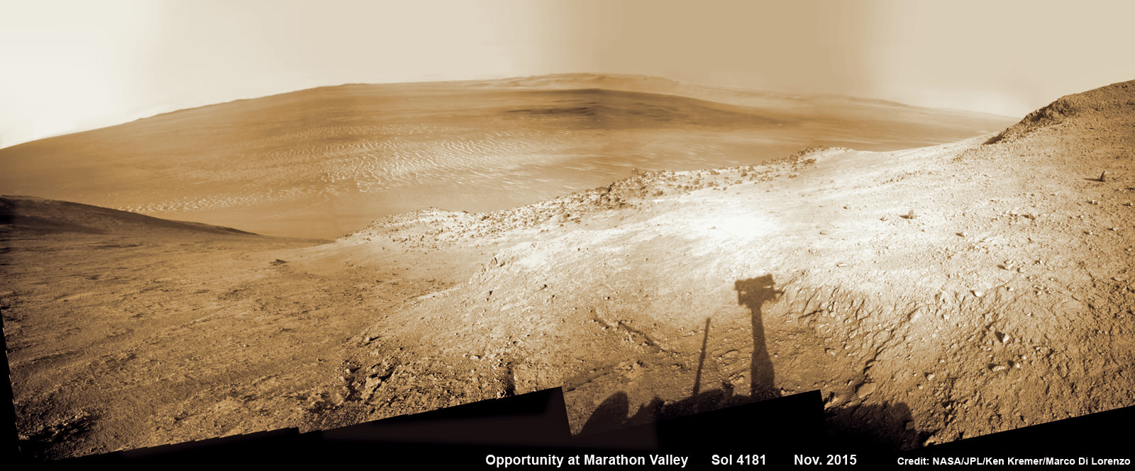
NASA’s Opportunity rover peers outwards across to the vast expense of Endeavour Crater from current location descending along steep walled Marathon Valley in early November 2015. Marathon Valley holds significant deposits of water altered clay minerals holding clues to the planets watery past. Shadow of Pancam Mast assembly and robots deck visible at right. This navcam camera photo mosaic was assembled from images taken on Sol 4181 (Oct. 29, 2015) and colorized. Credit: NASA/JPL/Cornell/Ken Kremer/kenkremer.com/Marco Di Lorenzo
NASA’s Opportunity rover peers outwards across to the vast expense of Endeavour Crater from current location descending along steep walled Marathon Valley in early November 2015. Marathon Valley holds significant deposits of water altered clay minerals holding clues to the planets watery past. Shadow of Pancam Mast assembly and robots deck visible at right. This navcam camera photo mosaic was assembled from images taken on Sol 4181 (Oct. 29, 2015) and colorized. Credit: NASA/JPL/Cornell/Ken Kremer/kenkremer.com/Marco Di Lorenzo
Just shy of an unfathomable 4200 Sols traversing ravishing alien terrain on the Red Planet, the longest living ‘Martian’ – NASA’s robot ‘Opportunity’ – is driving between “lily pads” down steep walled Marathon Valley in search of life giving sun that enables spectacular science yielding clues to Marswatery past. All this as she strives to survive utterly harsh climate extremes, because ‘winter is coming’ for her seventh time on the fourth rock from the sun!
“Opportunity is driving east and southeast down Marathon Valley, bisecting the region in which we detect smectites [clay minerals] using CRISM [spectrometer] data,” Opportunity Deputy Principal Investigator Ray Arvidson, of Washington University in St. Louis, told Universe Today.
Panoramic view from NASA’s Opportunity rover looking down the floor of Marathon Valley and out to the vast expense of Endeavour Crater. Marathon Valley holds significant deposits of water altered clay minerals. This composite photo mosaic shows the rover’s robotic arm reaching out at left to investigate Martian rocks holding clues to the planets watery past, and robot shadow and wheel tracks visible at right. The mosaic combines a flattened fisheye hazcam image at left with a trio of navcam camera images taken on Sol 4144 (Sept. 20, 2015) and colorized. Credit: NASA/JPL/Cornell/Ken Kremer/kenkremer.com/Marco Di Lorenzo
As NASA’s Opportunity rover approaches the 12th anniversary of landing on Mars, her greatest science discoveries yet are likely within grasp in the coming months since she has successfully entered Marathon Valley from atop a Martian mountain and is now prospecting downhill for outcrops of water altered clay minerals.
The valley is the gateway to alien terrain holding significant caches of the water altered minerals that formed under environmental conditions conducive to support Martian microbial life forms, if they ever existed. But as anyone who’s ever climbed down a steep hill knows, you have to be extra careful not to slip and slide and break something, no matter how beautiful the view is – Because no one can hear you scream on Mars! See the downward looking valley view above.
After a years long Martian mountain climbing and mountain top exploratory trek, Opportunity entered a notch named Marathon Valley from atop a breathtakingly scenic ridge overlook atop the western rim of Endeavour Crater.
Marathon Valley measures about 300 yards or meters long and cuts downhill through the west rim of Endeavour crater from west to east. Endeavour crater spans some 22 kilometers (14 miles) in diameter.
See our photo mosaics illustrating Opportunity’s view around and about Marathon Valley and Endeavour Crater, created by the image processing team of Ken Kremer and Marco Di Lorenzo.
Our mosaic above affords a downward looking view from Marathon Valley on Sol 4144, Sept. 20. It uniquely combines raw images from the hazcam and navcam cameras to gain a wider perspective panoramic view of the steep walled valley, and also shows the rover at work stretching out the robotic arm to potential clay mineral rock targets at left. Opportunity’s shadow and wheel tracks are visible at right.
Mosaic view from Opportunity rover looking along the high walls and down the floor of Marathon Valley with deposits of water altered clay minerals and out to the vast expense of Endeavour Crater. This navcam camera photo mosaic was assembled from images taken on Sol 4159 (Oct. 5, 2015) and colorized. Credit: NASA/JPL/Cornell/Marco Di Lorenzo/Ken Kremer/kenkremer.com
In late July, Opportunity began the decent into the valley from the western edge and started investigating scientifically interesting rock targets by conducting a month’s long “walkabout” survey ahead of the upcoming frigid Martian winter – the seventh since touchdown at Meridiani Planum in January 2004.
The walkabout was done to identify targets of interest for follow up scrutiny in and near the valley floor. Opportunity’s big sister Curiosity conducted a similarly themed “walkabout” at the base of Mount Sharp near her landing site located on the opposite side of the Red Planet.
“The valley is somewhat like a chute directed into the crater floor, which is a long ways below. So it is somewhat scary, but also pretty interesting scenery,” writes Larry Crumpler, a science team member from the New Mexico Museum of Natural History & Science, in a mission update.
“Its named Marathon Valley because the rover traveled one marathon’s distance to reach it,” Prof. Ray Arvidson, the rover Deputy Principal Investigator of Washington University told Universe Today.
The NASA rover exceeded the distance of a marathon on the surface of Mars on March 24, 2015, Sol 3968. Opportunity has now driven over 26.46 miles (42.59 kilometers) over nearly a dozen Earth years.
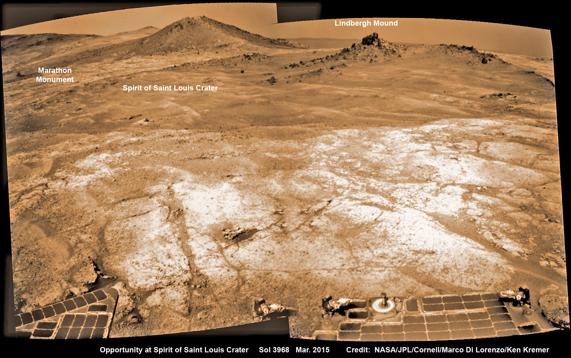
Opportunity’s view (annotated) on the day the NASA rover exceeded the distance of a marathon on the surface of Mars on March 24, 2015, Sol 3968 with features named in honor of Charles Lindbergh’s historic solo flight across the Atlantic Ocean in 1927. Rover stands at Spirit of Saint Louis Crater near mountaintop at Marathon Valley overlook and Martian cliffs at Endeavour crater holding deposits of water altered clay minerals. This navcam camera photo mosaic was assembled from images taken on Sol 3968 (March 24, 2015) and colorized. Credit: NASA/JPL/Cornell/Marco Di Lorenzo/Ken Kremer/kenkremer.com
Now for the first time in history, a human emissary has arrived to conduct an up close inspection of and elucidate clues into this regions potential regarding Martian habitability.
The ancient, weathered slopes around Marathon Valley hold a motherlode of ‘phyllosilicate’ clay minerals, based on data obtained from the extensive Mars orbital measurements gathered by the CRISM spectrometer on NASA’s Mars Reconnaissance Orbiter (MRO) – accomplished earlier at the direction of Arvidson.
‘Hinners Point’ Above Floor of ‘Marathon Valley’ on Mars. This Martian scene shows contrasting textures and colors of “Hinners Point,” at the northern edge of “Marathon Valley,” and swirling reddish zones on the valley floor to the left. Credit: NASA/JPL-Caltech/Cornell Univ./Arizona State Univ.
Initially the science team was focused on investigating the northern region of the valley while the sun was still higher in the sky and generating more power for research activities from the life giving solar arrays.
“We have detective work to do in Marathon Valley for many months ahead,” said Opportunity Deputy Principal Investigator Ray Arvidson, of Washington University in St. Louis.
But now that the rover is descending into a narrow valley with high walls, the rovers engineering handlers back on Earth have to exercise added caution regarding exactly where they send the Opportunity on her science forays during each sols drive, in order to maintain daily communications.
The high walls to the north and west of the valley ridgeline has already caused several communications blackouts for the “low-elevation Ultra-High-Frequency (UHF) relay passes to the west,” according to the JPL team controlling the rover.
Indeed on two occasions in mid September – coinciding with the days just before and after our Sol 4144 (Sept. 20) photo mosaic view above, “no data were received as the orbiter’s flight path was below the elevation on the valley ridgeline.
On Sept 17 and Sept. 21 “the high ridgeline of the valley obscured the low-elevation pass” and little to no data were received. However the rover did gather imagery and spectroscopic measurements for later transmission.
Now that winter is approaching the rover is moving to the southern side of Marathon Valley to soak up more of the sun’s rays from the sun-facing slope and continue research activities.
“During the Martian late fall and winter seasons Opportunity will conduct its measurements and traverses on the southern side of the valley,” says Arvidson.
“When spring arrives the rover will return to the valley floor for detailed measurements of outcrops that may host the clay minerals.”
The shortest-daylight period of this seventh Martian winter for Opportunity will come in January 2016.
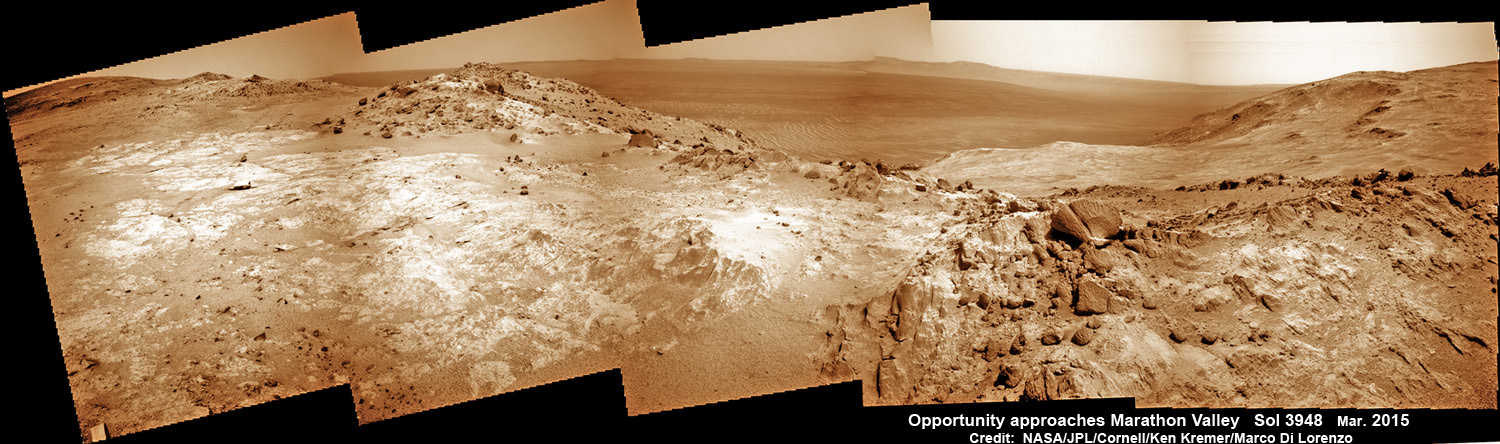
NASA’s Opportunity Rover scans along a spectacular overlook toward Marathon Valley on March 3, 2015, showing flat-faced rocks exhibiting a completely new composition from others examined earlier. Marathon Valley and Martian cliffs on Endeavour crater hold deposits of water altered clay minerals. This navcam camera photo mosaic was assembled from images taken on Sol 3948 (March 3, 2015) and colorized. Credit: NASA/JPL/Cornell/Ken Kremer/kenkremer.com/Marco Di Lorenzo
As of today, Sol 4168, Oct, 15, 2015 Opportunity has taken over 206,300 images and traversed over 26.46 miles (42.59 kilometers).
Stay tuned here for Ken’s continuing Earth and planetary science and human spaceflight news.
Nearly 12 Year Traverse Map for NASA’s Opportunity rover from 2004 to 2015
This map shows the entire path the rover has driven during almost 12 years and more than a marathon runners distance on Mars for over 4163 Sols, or Martian days, since landing inside Eagle Crater on Jan 24, 2004 – to current location at the western rim of Endeavour Crater and descending into Marathon Valley. Rover surpassed Marathon distance on Sol 3968 and marked 11th Martian anniversary on Sol 3911. Opportunity discovered clay minerals at Esperance – indicative of a habitable zone – and is currently searching for more at Marathon Valley. Credit: NASA/JPL/Cornell/ASU/Marco Di Lorenzo/Ken Kremer/kenkremer.com
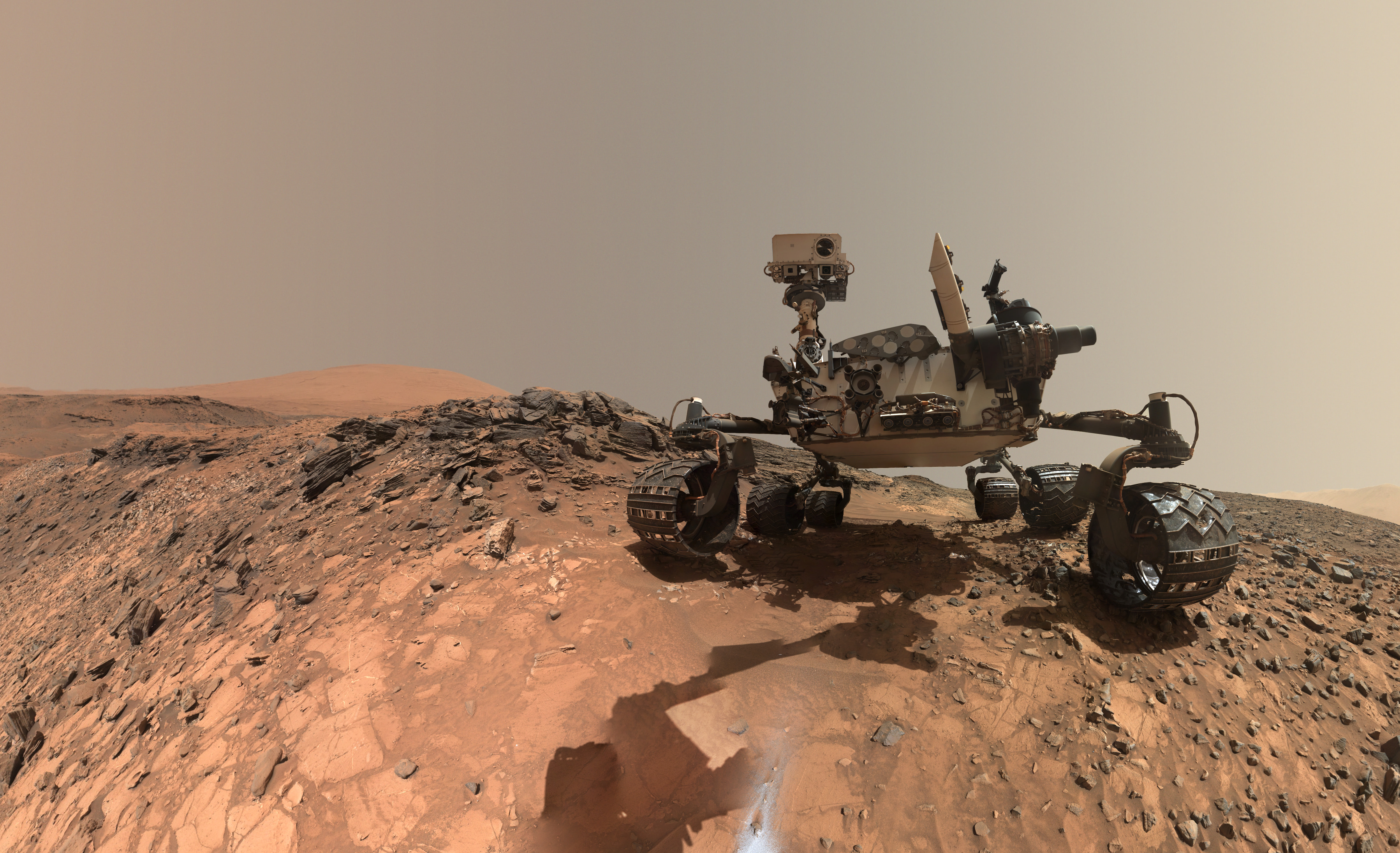
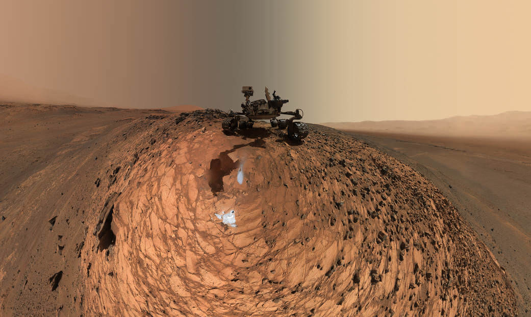
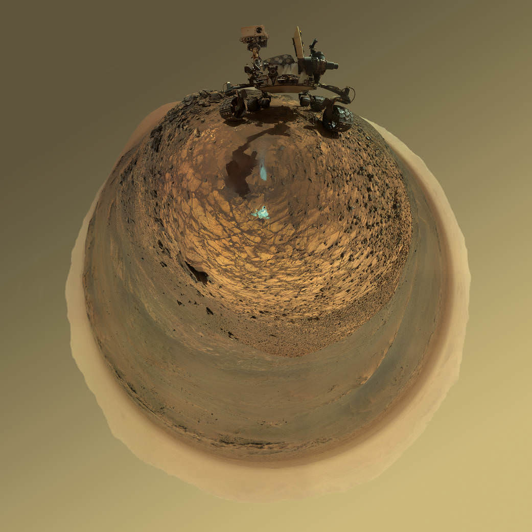
This low-angle self-portrait of NASA's Curiosity Mars rover shows the vehicle at the site from which it reached down to drill into a rock target called "Buckskin." The MAHLI camera on Curiosity's robotic arm took multiple images on Aug. 5, 2015, that were stitched together into this selfie. Credits: NASA/JPL-Caltech/MSSS
This low-angle self-portrait of NASA’s Curiosity Mars rover shows the vehicle at the site from which it reached down to drill into a rock target called “Buckskin.” The MAHLI camera on Curiosity’s robotic arm took multiple images on Aug. 5, 2015, that were stitched together into this selfie. Credits: NASA/JPL-Caltech/MSSS
More selfie and drilling mosaics below[/caption]
The unique self portrait was taken from a low-angle for the first time and shows the six wheeled rover at work collecting her seventh drilled sample at the ‘Buckskin’ rock target earlier this month in the “Marias Pass” area of lower Mount Sharp.
‘Buckskin’ is also unique in a fabulously scientifically way because the rover discovered a new type of Martian rock that’s surprisingly rich in silica – and unlike any other targets found before.
The low camera angle is what enables the awesome Buckskin belly selfie. It’s a distinctively dramatic view and actually stitched from 92 images captured by the Mars Hand Lens Imager (MAHLI) on Aug. 5, 2015, or Sol 1065 of the mission.
The high resolution MAHLI color camera is located on the end of the 7 foot-long (2.1 meter-long) robotic arm.
This version of a self-portrait of NASA’s Curiosity Mars rover at a drilling site called “Buckskin” is presented as a stereographic projection, which shows the horizon as a circle. The MAHLI camera on Curiosity’s robotic arm took dozens of component images for this selfie on Aug. 5, 2015. Credits: NASA/JPL-Caltech/MSSS
Indeed the car-sized rover has taken spectacular selfies several times before during her three year long trek across the Martian surface, since the August 2012 landing inside Mars’ Gale Crater. But for those past selfies the MAHLI camera was hoisted higher to give the perspective of looking somewhat downward and showing the rovers top deck and trio of sample inlet ports.
In this case, the rover team specifically commanded Curiosity to position “the camera lower in relation to the rover body than for any previous full self-portrait of Curiosity,” said NASA officials.
Two patches of gray colored powdered rock material drilled from Buckskin are visible in the selfie scene, in front of the rover.
“The patch closer to the rover is where the sample-handling mechanism on Curiosity’s robotic arm dumped collected material that did not pass through a sieve in the mechanism. Sieved sample material was delivered to laboratory instruments inside the rover. The patch farther in front of the rover, roughly triangular in shape, shows where fresh tailings spread downhill from the drilling process.”
Prior selfies were taken at the “Rocknest” (http://photojournal.jpl.nasa.gov/catalog/PIA16468), “John Klein” (http://photojournal.jpl.nasa.gov/catalog/PIA16937), “Windjana” (http://photojournal.jpl.nasa.gov/catalog/PIA18390) and “Mojave” drill sites.
Basically in the Sol 1065 belly selfie at “Buckskin” we see the underbelly of the rover and all six wheels along with a complete self portrait.
This version of a self-portrait of NASA’s Curiosity Mars rover at a drilling site called “Buckskin” is presented as a stereographic projection, which shows the horizon as a circle. The MAHLI camera on Curiosity’s robotic arm took dozens of component images for this selfie on Aug. 5, 2015. Credits: NASA/JPL-Caltech/MSSS
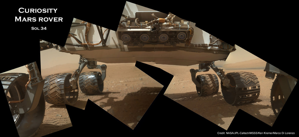
On several prior occasions, MAHLI was used to image just the underbelly and wheels to aid in inspecting the wheels to look for signs of damage inflicted by sharp-edged Martian rocks poking holes in the aluminum wheels.
Underbelly view of Curiosity rover and wheels on Sol 34, Sept. 9, 2012. Credit: NASA/JPL/MSSS/Ken Kremer/Marco Di Lorenzo
Each wheel measures 20 inches (50 centimeters) in diameter and about 16 inches (40 centimeters) wide. And the MAHLI monitoring images have shown the effects of increasing wear and tear that ultimately forced the rover drivers to alter Curiosity’s driving route on the crater floor in favor of smoother and less rocky terrain imparting less damage to the critical wheels.
If you take a close look at the new selfie up top, you’ll see a small rock stuck onto Curiosity’s left middle wheel (on the right in this head-on view). The rock was seen also in prior wheel monitoring images taken three weeks ago.
“The selfie at Buckskin does not include the rover’s robotic arm beyond a portion of the upper arm held nearly vertical from the shoulder joint. With the wrist motions and turret rotations used in pointing the camera for the component images, the arm was positioned out of the shot in the frames or portions of frames used in this mosaic,” according to officials.
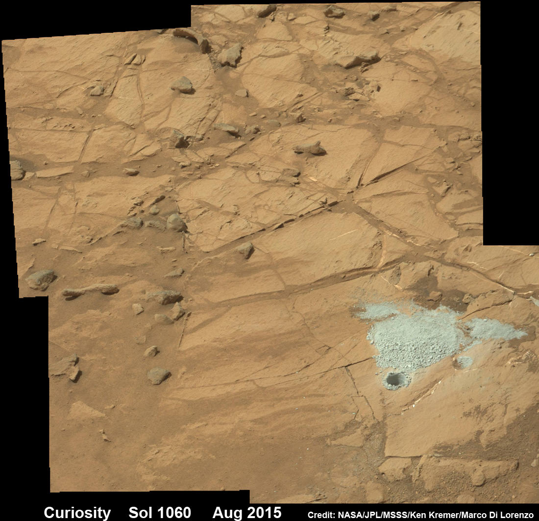
The drilling campaign into “Buckskin” was successfully conducted on Sol 1060 (July 30, 2015) at the bright toned “Lion” outcrop to a full depth of about 2.6 inches (6.5 centimeters) and approximately 1.6 cm (0.63 inch) diameter.
Curiosity extends robotic arm and conducts sample drilling at “Buckskin” rock target at bright toned “Lion” outcrop at the base of Mount Sharp on Mars, seen at right. Gale Crater eroded rim seen in the distant background at left, in this composite multisol mosaic of navcam raw images taken to Sol 1059, July 30, 2015. Navcam camera raw images stitched and colorized. Inset: MAHLI color camera up close image of full depth drill hole at “Buckskin” rock target on Sol 1060. Credit: NASA/JPL-Caltech/MSSS/Ken Kremer/kenkremer.com/Marco Di Lorenzo
You can also see another perspective of the rover at work while reaching out with the robotic arm and drilling into ‘Buckskin’ as illustrated in our mosaics of mastcam and navcam camera raw images created by the image processing team of Ken Kremer and Marco Di Lorenzo.
The main bore hole was drilled next to the initial mini hole test and shows the indicative residue of grey colored tailings from the Martian subsurface seen distributed around the new hole.
Curiosity rover successfully drills into Martian outcrop at Buckskin rock target at current work site at base of Mount Sharp in August 2015, in this mosaic showing full depth drill hole and initial test hole, with grey colored subsurface tailings and mineral veins on surrounding Red Planet terrain. This high resolution photo mosaic is a multisol composite of color images taken by the mast mounted Mastcam-100 color camera up to Sol 1060, July 31, 2015. Credit: NASA/JPL-Caltech/Ken Kremer/kenkremer.com/Marco Di Lorenzo
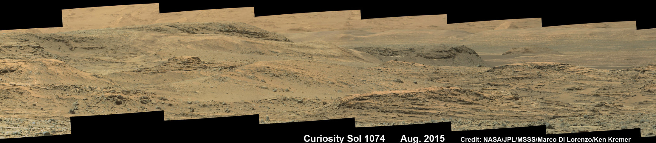
Curiosity has now moved on from the “Marias Pass” area.
As of today, Sol 1080, August 20, 2015, she has driven some 6.9 miles (11.1 kilometers) kilometers and taken over 260,000 amazing images.
Curiosity rover scans toward south east around Marias Pass area at the base of Mount Sharp on Mars on Sol 1074, Aug. 14, 2015 in this photo mosaic stitched from Mastcam color camera raw images. Credit: NASA/JPL/MSSS/Marco Di Lorenzo/Ken Kremer/kenkremer.com
Curiosity has already accomplished her primary objective of discovering a habitable zone on the Red Planet – at the Yellowknife Bay area – that contains the minerals necessary to support microbial life in the ancient past when Mars was far wetter and warmer billions of years ago.
Stay tuned here for Ken’s continuing Earth and planetary science and human spaceflight news.
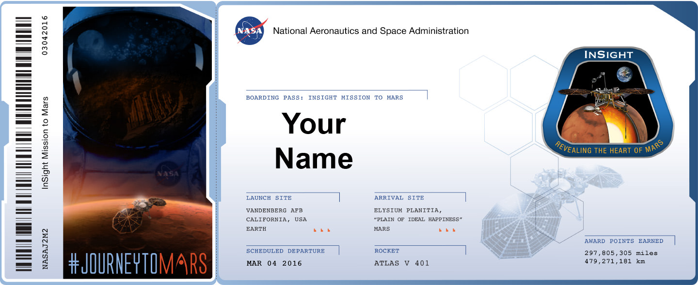
Sign up to send your name to Mars on InSight, NASA’s next mission to Mars launching in March 2016. Credit: NASA
Sign up to send your name to Mars on InSight, NASA’s next mission to Mars launching in March 2016. Credit: NASA Sign up link below – don’t delay![/caption]
NASA invites you to ‘Send Your Name to Mars’ on a silicon microchip aboard the InSight probe slated for blastoff on March 4, 2016 from Vandenberg Air Force Base, California.
InSight’s science goal is totally unique – to “listen to the heart of Mars to find the beat of rocky planet formation.”
The public can submit their names for inclusion on a dime-sized microchip that will travel on a variety of spacecraft voyaging to destinations beyond low-Earth orbit, including Mars.
“Our next step in the journey to Mars is another fantastic mission to the surface,” said Jim Green, director of planetary science at NASA Headquarters in Washington.
“By participating in this opportunity to send your name aboard InSight to the Red Planet, you’re showing that you’re part of that journey and the future of space exploration.”
In just the first 24 hours over 67,000 Mars enthusiasts have already signed up!
But time is of the essence since the deadline to submit your name is soon: Sept. 8, 2015.
How can you sign up to fly on InSight? Is there a certificate?
NASA has made it easy to sign up.
To send your name to Mars aboard InSight, click on this weblink posted online by NASA:
And you can also print out an elegant looking ‘Boarding Pass’ that looks like this:
Boarding Pass with frequent flyer miles for NASA’s InSight Mission to Mars – launching from Vandenberg Air Force Base, California in March 2016. Credit: NASA
Furthermore the ‘Boarding Pass’ also comes with a listing of your “frequent flier” points accumulated by your participation in NASA’s ‘fly-your-name opportunity’ that will span multiple missions and multiple decades beyond low Earth orbit.
InSight represents the second ‘fly-your-name opportunity’ in NASA’s journey to Mars program. The uncrewed Orion EFT-1 mission launched on Dec. 5, 2014 was the first chance for space fans to collect ‘Journey to Mars’ points by sending your names to space.
Over 1.38 million people flew on the silicon chip aboard the maiden flight of Orion, the NASA capsule that will eventually transport humans to the Red Planet in the 2030s.
Don’t dawdle. Because after InSight, you’ll have to wait about three years until late 2018 and the blastoff of the next Orion capsule on NASA’s Exploration Mission-1 (EM-1) for you next chance to accumulate “frequent flier” points on a ‘Journey to Mars’ mission.
Orion EM-1 will launch atop NASA’s mammoth Space Launch System (SLS) rocket, and NASA just conducted a key test firing on Aug. 13 of the first stage engines that will power the stack to on a mission to the Moon – detailed in my recent story here.
InSight, which stands for Interior Exploration Using Seismic Investigations, Geodesy and Heat Transport, is a stationary lander.
It will join NASA’s surface science exploration fleet currently comprising of the Curiosity and Opportunity missions which by contrast are mobile rovers.
InSight is the first mission to understand the interior structure of the Red Planet. Its purpose is to elucidate the nature of the Martian core, measure heat flow and sense for “Marsquakes.”
“It will place the first seismometer directly on the surface of Mars to measure Martian quakes and use seismic waves to learn about the planet’s interior. It also will deploy a self-hammering heat probe that will burrow deeper into the ground than any previous device on the Red Planet. These and other InSight investigations will improve our understanding about the formation and evolution of all rocky planets, including Earth,” says NASA.
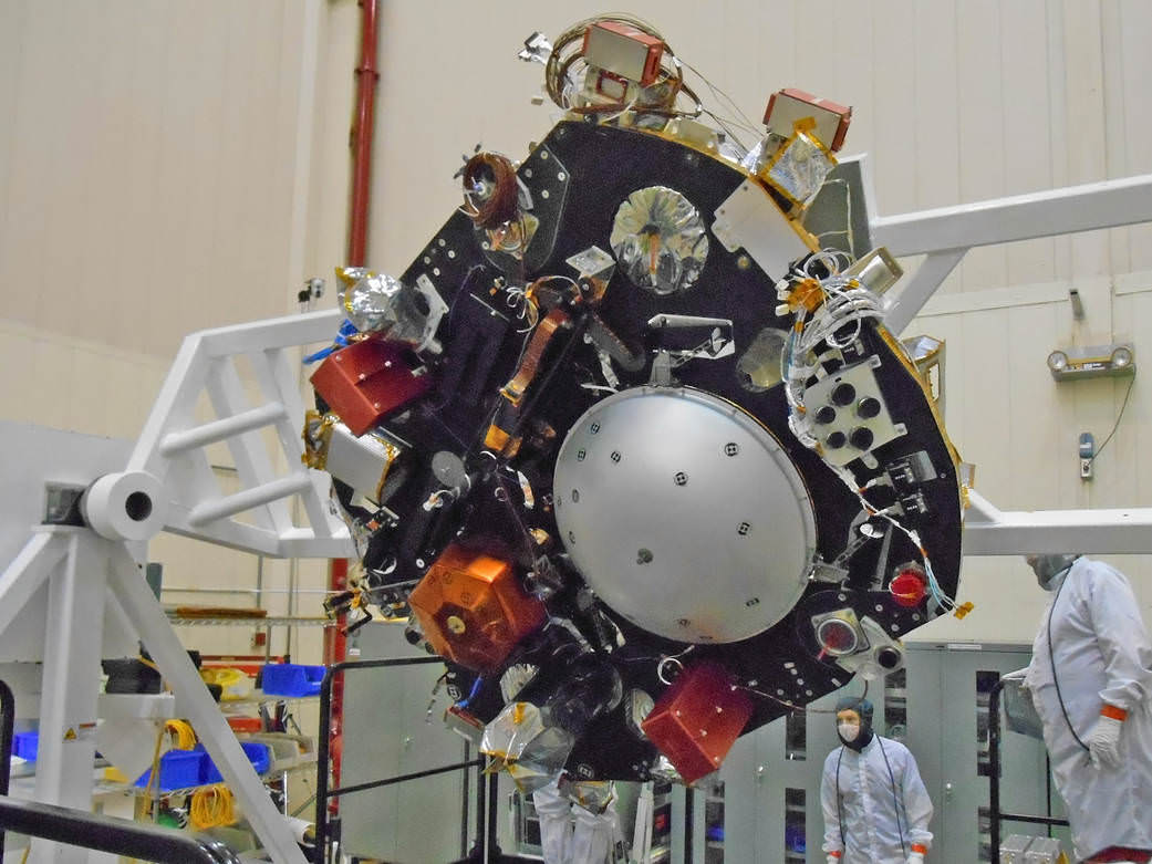
NASA’s InSight Mars lander spacecraft in a Lockheed Martin clean room near Denver. As part of a series of deployment tests, the spacecraft was commanded to deploy its solar arrays in the clean room to test and verify the exact process that it will use on the surface of Mars. Credits: NASA/JPL-Caltech/Lockheed Martin
The countdown clock is ticking relentlessly towards liftoff in less than seven months time in March 2016.
Insight promises to ‘science the sh**’ out of the heart of Mars!
It is funded by NASA’s Discovery Program as well as several European national space agency’s and countries. Germany and France are providing InSight’s two main science instruments; The HP3 heat probe and the SEIS seismometer through the Deutsches Zentrum für Luft- und Raumfahrt. or German Aerospace Center (DLR) and the Centre National d’Etudes Spatiales (CNES).
“Together, humans and robotics will pioneer Mars and the solar system,” says Green.
InSight Boarding pass
Stay tuned here for Ken’s continuing Earth and planetary science and human spaceflight news.
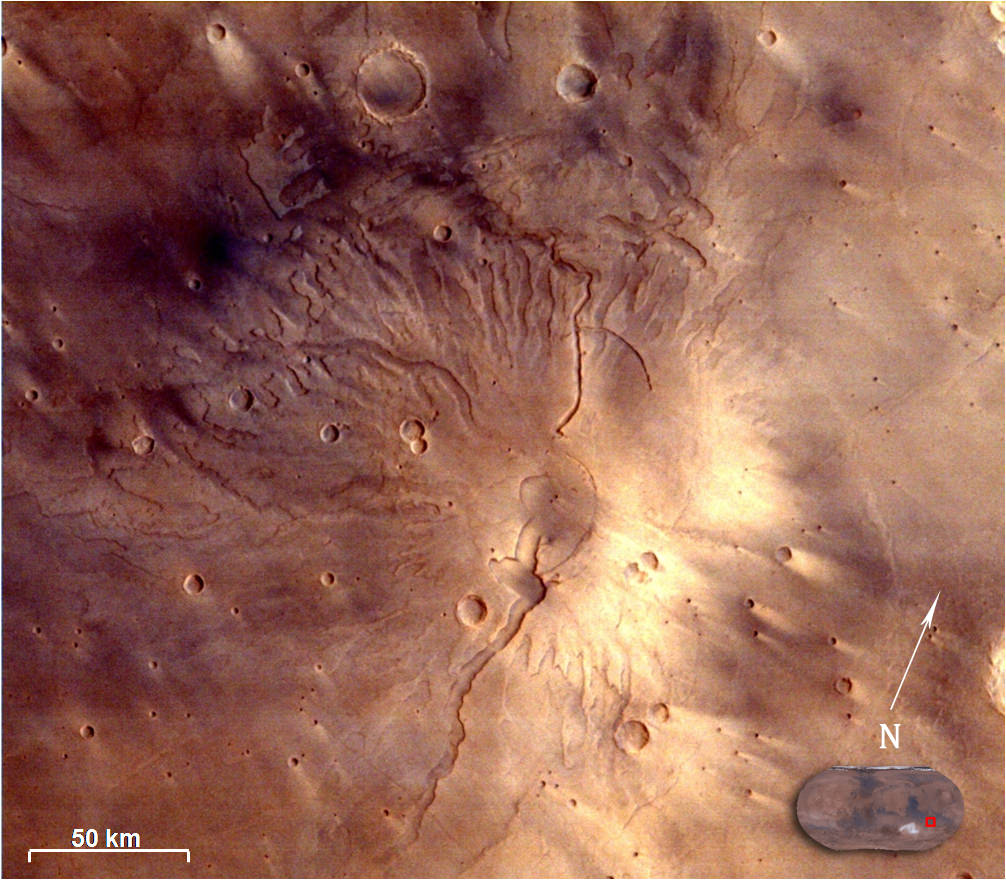
Spectacular 3D view of Arsia Mons, a huge volcano on Mars, taken by camera on India's Mars Orbiter Mission (MOM). Credit: ISRO
Spectacular 3D view of Arsia Mons, a huge volcano on Mars, taken by camera on India’s Mars Orbiter Mission (MOM). Credit: ISRO
Story updated with more details and imagery[/caption]
The Indian Space Research Organization (ISRO), India’s space agency, has recently published a beautiful gallery of images featuring a variety of picturesque Martian canyons, volcanoes, craters, moons and more.
We’ve gathered a collection here of MOM’s newest imagery snapped by the probes Mars Color Camera (MCC) for the enjoyment of Martian fans worldwide.
The spectacular 3D view of the Arsia Mons volcano, shown above, was “created by draping the MCC image on topography of the region derived from the Mars Orbiter Laser Altimeter (MOLA), one of five instruments on board NASA’s Mars Global Surveyor (MGS) spacecraft.
The Arsia Mons image was taken from Mars orbit on 1 April 2015 at a spatial resolution of 556 meters from an altitude of 10707 km. Volcanic deposits can be seen located at the flanks of the Mons, according to ISRO.
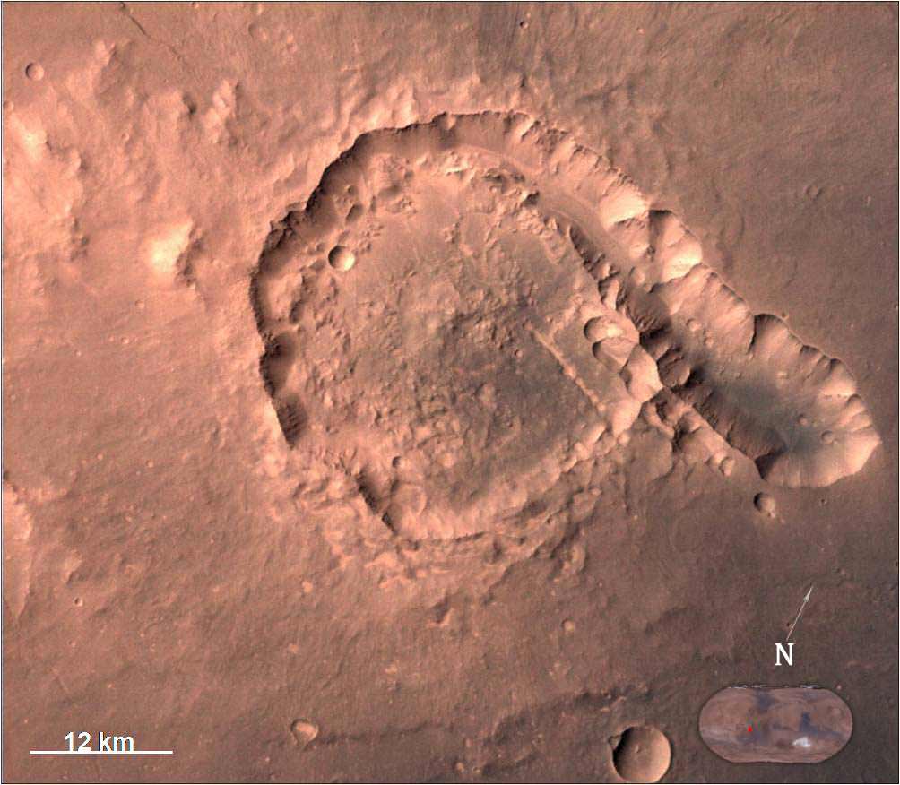
The view of Pital crater below was released in late May and taken on 23 April 2015. Pital is a 40 km wide impact crater located in the Ophir Planum region of Mars and the image shows a chain of small impact craters. It is located in the eastern part of Valles Marineris region, says an ISRO description. MCC took the image from an altitude of 808 km.
Pital crater is an impact crater located in Ophir Planum region of Mars, which is located in the eastern part of Valles Marineris region. This image is taken by Mars Color Camera (MCC) on 23-04-2015 at a spatial resolution of ~42 m from an altitude of 808 km. Credit: ISRO
It is an odd shaped crater, neither circular nor elliptical in shape, possibly due to “regional fracture in the W-E trending fracture zone.”
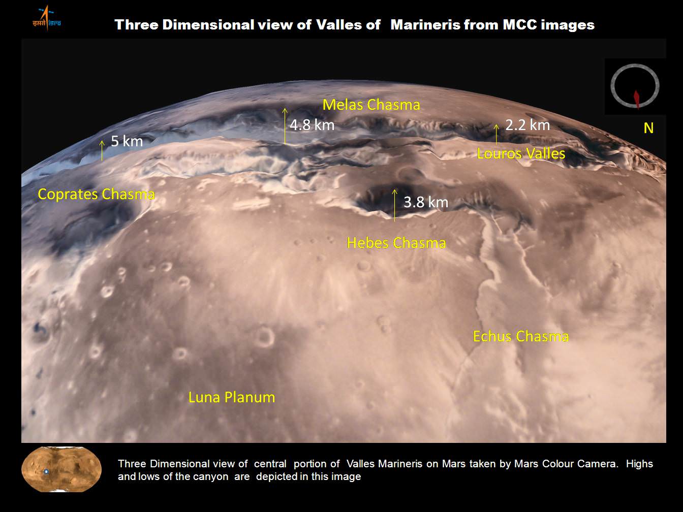
A trio of images, including one in stunning 3D, shows various portions of Valles Marineris, the largest known canyon in the Solar System.
Three dimensional view of Valles Marineris center portion from India’s MOM Mars Mission. Credit: ISRO
Valles Marineris stretches over 4,000 km (2,500 mi) across the Red Planet , is as much as 600 km wide and measures as much as 7 kilometers (4 mi) deep.
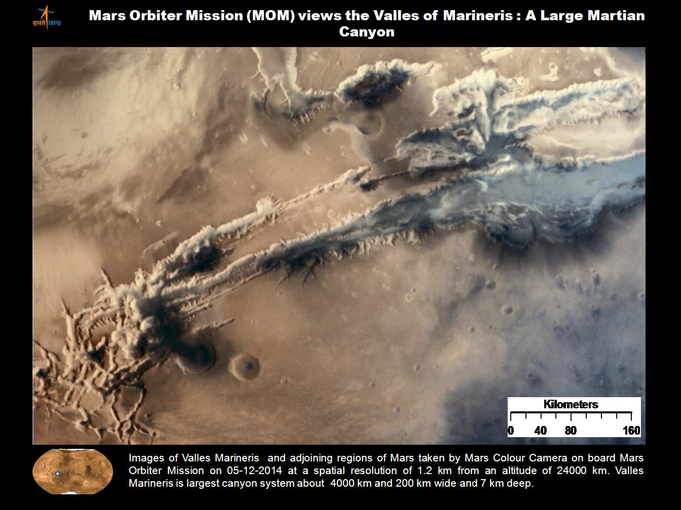
Valles Marineris from India’s Mars Mission. Credit: ISRO
For context here’s a previously taken global image of the red planet from MOM showing Valles Marinaris and Arsia Mons, which belongs to the Tharsis Bulge trio of shield volcanoes. They are both near the Martian equator.
Olympus Mons, Tharsis Bulge trio of volcanoes and Valles Marineris from ISRO’s Mars Orbiter Mission. Note the clouds and south polar ice cap. Credit: ISRO
Valles Marineris is often called the “Grand Canyon of Mars.” It spans about as wide as the entire United States.
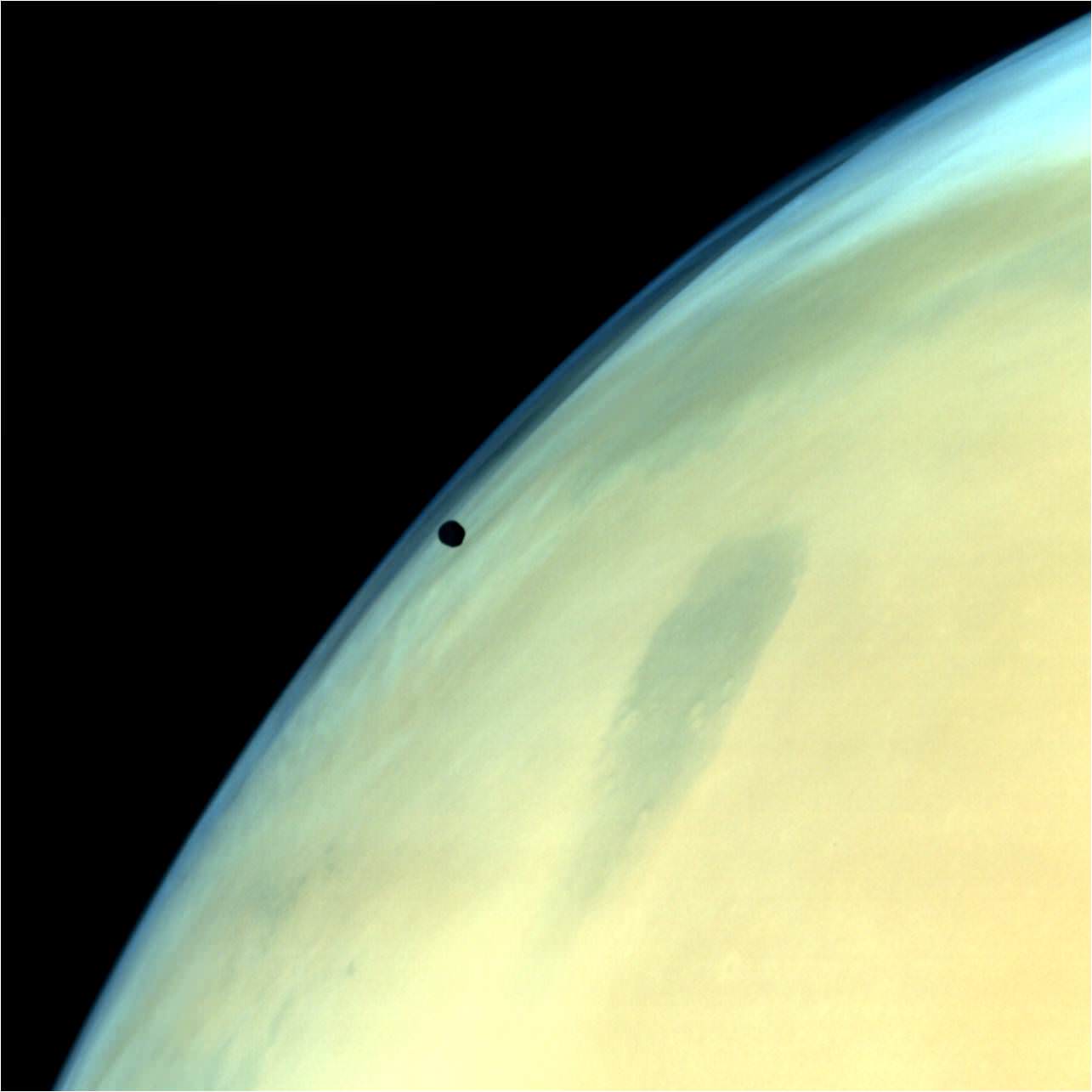
A gorgeous view of Phobos, the largest of Mars’ two tiny moons, silhouetted against the surface is shown below.
Phobos, one of the two natural satellites of Mars silhouetted against the Martian surface. Credit: ISRO
MOM’s goal is to study Mars atmosphere, surface environments, morphology, and mineralogy with a 15 kg (33 lb) suite of five indigenously built science instruments. It is also sniffing for methane, a potential marker for biological activity.
MOM is India’s first deep space voyager to explore beyond the confines of her home planets influence and successfully arrived at the Red Planet after the “history creating” orbital insertion maneuver on Sept. 23/24, 2014 following a ten month journey from Earth. MOM swoops around Mars in a highly elliptical orbit whose nearest point to the planet (periapsis) is at about 421 km and farthest point (apoapsis) at about 76,000 km, according to ISRO.
It takes MOM about 3.2 Earth days or 72 hours to orbit the Red Planet.
Higher resolution view of a portion of Valles Marineris canyon from India’s MOM Mars Mission. Credit: ISRO
MOM was launched on Nov. 5, 2013 from India’s spaceport at the Satish Dhawan Space Centre, Sriharikota, atop the nations indigenous four stage Polar Satellite Launch Vehicle (PSLV) which placed the probe into its initial Earth parking orbit.
The $73 million MOM mission was expected to last at least six months. In March, ISRO extended the mission duration for another six months since its healthy, the five science instruments are operating fine and it has sufficient fuel reserves.
And with a communications blackout between Mars and Earth imminent as a result of natures solar conjunction, it’s the perfect time to catch up on all things Martian.
Solar conjunctions occur periodically between Mars and Earth about every 26 months, when the two planets line up basically in a straight line geometry with the sun in between as the two planets travel in their sun-centered orbits.
Since Mars will be located behind the Sun for most of June, communications with all the Terran spacecraft at the planet is diminished to nonexistent.
“MOM faces a communication outage during June 8-25,” according to The Hindu.
Normal science operations resume thereafter.
“Fuel on the spacecraft is not an issue,” ISRO Satellite Centre Director M. Annadurai told The Hindu.
Image of Tyrrhenus Mons in Hesperia Planum region taken by Mars Color Camera (MCC) on 25-02-2015 at a spatial resolution of 166m from an altitude of 3192km. Tyrrhenus Mons is an ancient martian volcano and image shows its timeworn gullies and wind streaks. Credit: ISRO
Including MOM, Earth’s invasion fleet at the Red Planet numbers a total of seven spacecraft comprising five orbiters from NASA, ESA and ISRO as well as the sister pair of mobile surface rovers from NASA – Curiosity and Opportunity.
Stay tuned here for Ken’s continuing Earth and planetary science and human spaceflight news.
NASA’s Martian Curiosity rover looks backs to 1000 Sols of science and exploration on the surface of the Red Planet. Robot wheel tracks lead back through valley dunes. Gale Crater rim seen in the distant hazy background. Sol 997 (May 28, 2015) navcam camera raw images stitched and colorized. Credit: NASA/JPL-Caltech/ Marco Di Lorenzo/Ken Kremer/kenkremer.com
Featured on APOD on June 13, 2015
Looking back 1000 Sols on the Red Planet
NASA’s Martian Curiosity rover looks backs to 1000 Sols of science and exploration on the surface of the Red Planet. Robot wheel tracks lead back through valley dunes. Gale Crater rim seen in the distant hazy background. Sol 997 (May 28, 2015) navcam camera raw images stitched and colorized. Credit: NASA/JPL-Caltech/ Marco Di Lorenzo/Ken Kremer/kenkremer.com Featured on APOD on June 13, 2015
Story updated[/caption]
The Martian Curiosity celebrates 1000 Sols on Mars!
Marking the occasion with utter glee, the car sized robot snapped a cool mosaic view (above) looking back to 1000 Sols of high impact exploration and discovery on the Red Planet, showing her wheel tracks leading back through valley dunes from the foothills of humongous Mount Sharp and across the alien surface floor and out to the distant rim of the Gale Crater landing site she descended to nearly three years ago in August 2012.
“A thousand thanks to the best team a rover could have. Celebrating 1,000 sols. Here’s to the Martian days ahead!” the robot tweeted.
But at 1K sols she’s not content to just bask in the Martian sunshine during the history making event. Rather, she is as always hard at work, reaching out with the high tech robotic arm and inspecting intriguing rock outcrops spread out all around her.
Check out Curiosity’s current workspace, looking back and hard at work in our new photo mosaics herein created by the imaging team of Marco Di Lorenzo and Ken Kremer. They are also featured at NBC News – here – and Alive Space Images (in Italian) – here and here.
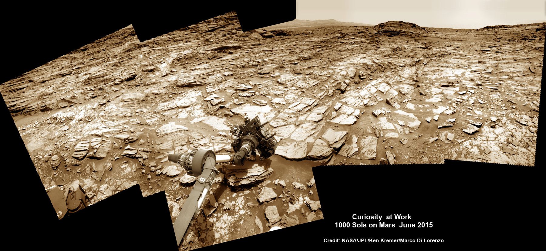
Curiosity rover at work for 1000 Sols on Mars
This composite multi sol photo mosaic shows outstretched robotic arm inspecting intriguing rock outcrops. The APXS spectrometer is investigating a target called ‘Ronan’ on the Stimson overlying outcrop. Navcam camera raw images taken from sols 997 to 1000 are stitched and colorized. Credit: NASA/JPL/Ken Kremer/kenkremer.com/Marco Di Lorenzo
The raw images for the look back mosaic were taken after she arrived at her current location on Martian Sol 997, or Earth’s Day May 28, 2015.
The Curiosity Mars Science Laboratory (MSL) rover officially celebrated 1000 Martian Sols on May 31, 2015 since she safely touched down on the crater floor on August 5, 2012 following the nail-biting and unprecedented sky crane maneuver that delivered her with pinpoint precision to a landing site nearby Mount Sharp.
“An MSL landmark day. We have reached 1000 sols on Mars. Looking back the remarkable thing is how few serious problems there have been,” says team member Professor John Bridges of the University of Leicester, England, in an update.
Exploring the sedimentary layers of Mount Sharp, which towers 3.4 miles (5.5 kilometers) into the Martian sky, form the primary destination and goal of her scientific expedition.
The six wheeled robot and her team of handlers back on Earth, are eeking out every last drop of science before she and all of Earth’s entire Martian invasion fleet enter solar conjunction, when Mars is behind the sun and little or no communications will be possible for most of the month of June. Activities will be limited per safety protocols.
“However, there is one issue even Curiosity can’t avoid – Conjunction. For much of June, Mars will be obscured from Earth by the Sun. Few science operations,” explains Bridges.
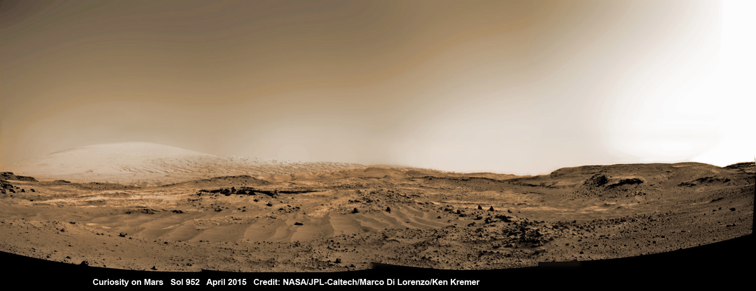
Curiosity rover rolls across Mars at the foothills of Mount Sharp, seen in the background, in this mosaic of images taken on April 11, 2015 (Sol 952). Navcam camera raw images stitched and colorized. Credit: NASA/JPL-Caltech/ Marco Di Lorenzo/Ken Kremer/kenkremer.com
After a short drive Curiosity arrived at her current location at “Marias Pass” on Sol 997, where she will stay stationary during the conjunction period out of an abundance of caution.
“A short bump on Sol 997 put Curiosity in a great position to investigate a few different rock units in Marias Pass, using the instruments on the rover’s arm,” wrote MSL and USGS mission scientist Ken Herkenhoff in an update.
She also reached within an eyelash of 10.6 kilometers (6.6 mi) of total driving.
“The 2.5 m drive brings our total odometry to 10,599 m,” noted Herkenoff.
Along the way she discovered the chemical ingredient minerals necessary to support life, as well as low levels of some organic molecules and some traces of methane, and and ample evidence for lakes and streams of liquid water.
“Curiosity is now parked for the next few weeks. But we are parked in front of a beautiful outcrop that shows the contact between the underlying Pahrump unit and the overlying Stimson unit.”
Our arm photo mosaic herein shows the seven foot (2 m) long robotic arm and its APXS spectrometer deployed at the target called “Ronan”, which is part of the overlying Stimson outcrop unit.
The rover is also using the ChemCam, MastCam and MAHLI cameras and spectrometers and other instruments to characterize the outcrop and its texture and composition in detail.
The robotic arm will be stowed during the June conjunction period.
Curiosity arrived at the Pahrump Hills at the base of Mount Sharp back in September 2014. Since then she has conducted an intensive investigation of the rocks and a trio of drilling operations to elucidate how this area fits in context with Mount Sharp and the habitable region discovered on the crater floor at Yellowknife Bay back in the spring of 2013.
In recent weeks, Curiosity has been driving up hills with slopes of as much as 21 degrees, higher than ever before, on an exciting journey endeavoring to slowly ascend up to the lower layers of Mount Sharp.
The current Martian outcrop area under investigation is a place where two distinctive geologic types of bedrock meet and where pale rock meets darker overlying rock.
“Such contacts can reveal clues about how the environmental conditions that produced one type of rock were related to the conditions that produced the other,” says NASA.
“The rover science team wants to examine an outcrop that contains the contact between the pale rock unit the mission analyzed lower on Mount Sharp and a darker, bedded rock unit that the mission has not yet examined up close.”
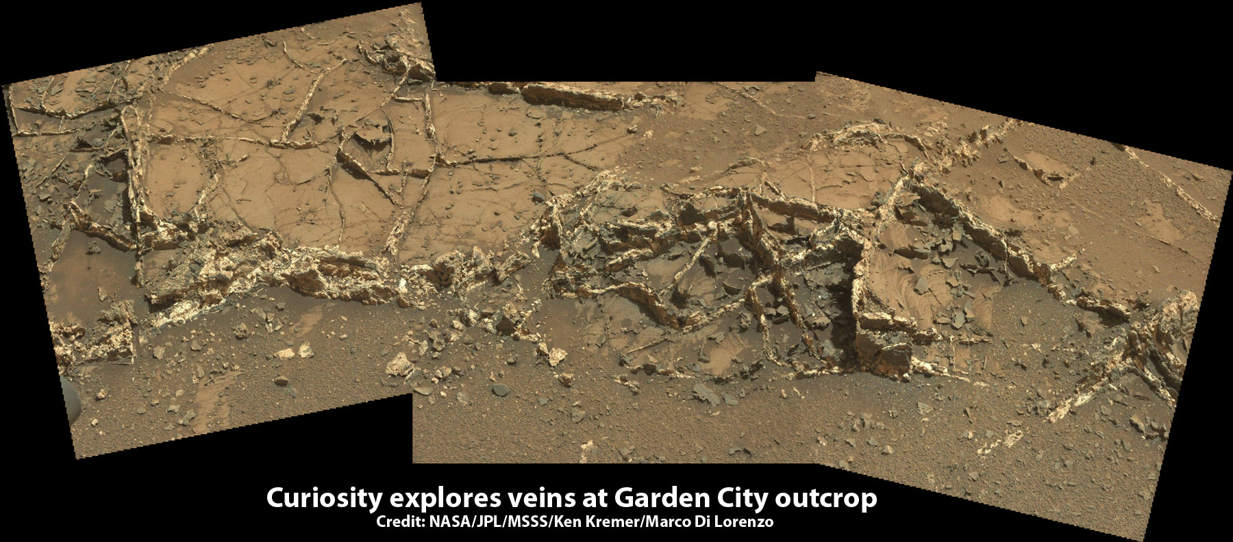
The team is also scouting around for the presence of mineral veins, like those recently discovered at the “Garden City” outcrop, that formed in the past during periods of flowing liquid water that could be favorable for microbial life forms if they ever existed.
Curiosity investigates a beautiful outcrop of scientifically enticing dark and light mineral veins at ”Garden City” outcrop at the base of Mount Sharp at current location on Mars. This photo mosaic was stitched from Mastcam color camera raw images. Credit: NASA/JPL-Caltech/MSSS/Ken Kremer/kenkremer.com/Marco Di Lorenzo
Because there’s a plethora of treacherous dunes, the team has had to monitor operations carefully and alter the route on occasion to maintain safe operations.
Curiosity has already accomplished her primary objective of discovering a habitable zone on the Red Planet that contains the minerals necessary to support microbial life in the ancient past when Mars was far wetter and warmer billions of years ago.
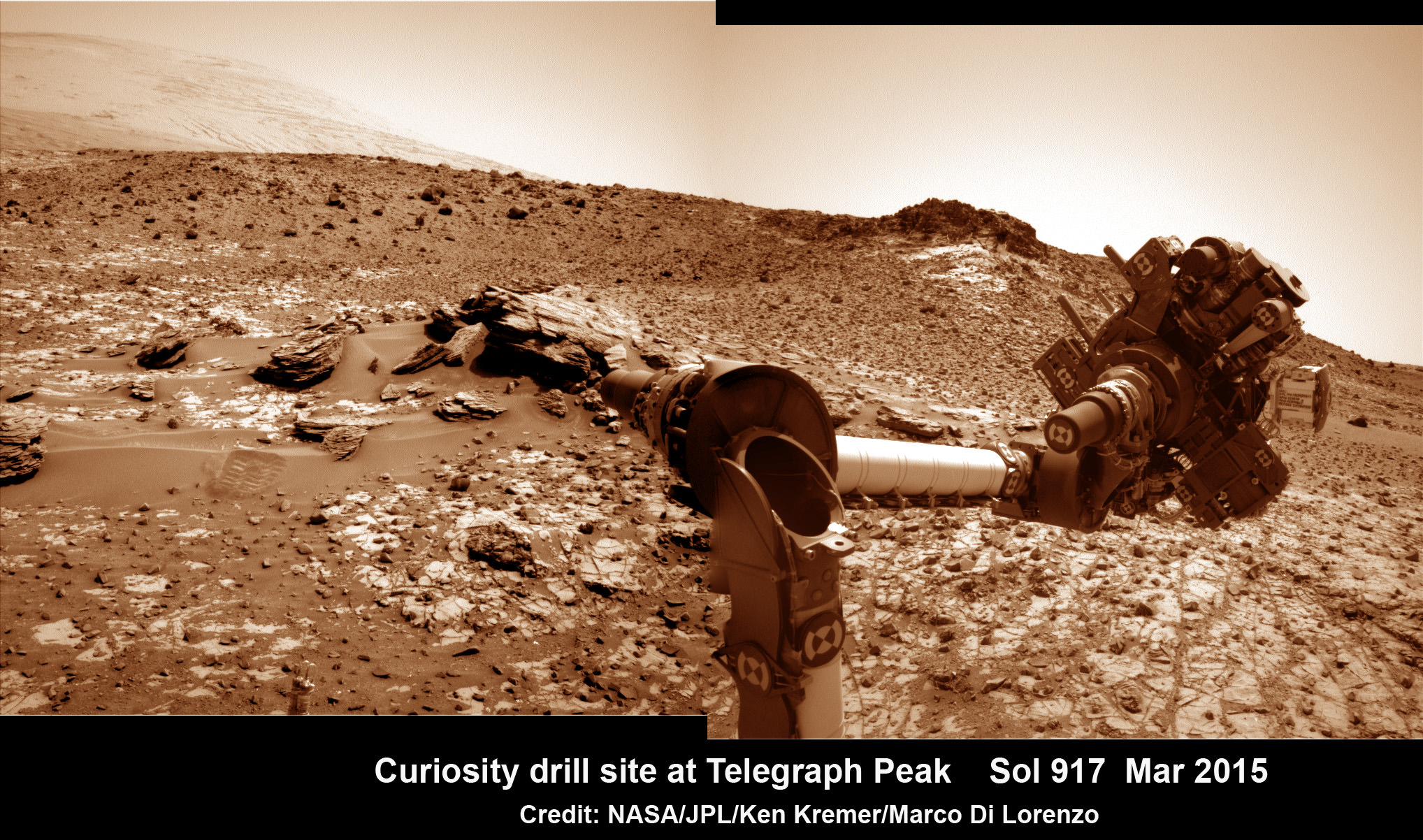
This March 6, 2015 (Sol 917), mosaic of images from the Navcam camera on NASA’s Curiosity Mars rover shows the position in which the rover held its arm for several days after a transient short circuit triggered onboard fault-protection programming to halt arm activities on Feb. 27, 2015, Sol 911. The rover team chose to hold the arm in the same position for several days of tests to diagnose the underlying cause of the Sol 911 event. Navcam camera raw images stitched and colorized. Credit: NASA/JPL-Caltech/Ken Kremer/kenkremer.com/Marco Di Lorenzo
To date, Curiosity’s odometer totals over 5.1 miles (8.4 kilometers) since landing inside Gale Crater on Mars in August 2012.
As of today, Sol 1001, June 1, 2015, she has taken over 246,000 amazing images.
Stay tuned here for Ken’s continuing Earth and planetary science and human spaceflight news.
NASA's InSight Mars lander spacecraft in a Lockheed Martin clean room near Denver. As part of a series of deployment tests, the spacecraft was commanded to deploy its solar arrays in the clean room to test and verify the exact process that it will use on the surface of Mars. Credits: NASA/JPL-Caltech/Lockheed Martin
NASA’s ‘Journey to Mars’ is ramping up significantly with ‘InSight’ – as the agency’s next Red Planet lander has now been assembled into its flight configuration and begun a comprehensive series of rigorous and critical environmental stress tests that will pave the path to launch in 2016 on a mission to unlock the riddles of the Martian core.
The countdown clock is ticking relentlessly and in less than nine months time, NASA’s InSight Mars lander is slated to blastoff in March 2016.
InSight, which stands for Interior Exploration Using Seismic Investigations, Geodesy and Heat Transport, is a stationary lander. It will join NASA’s surface science exploration fleet currently comprising of the Curiosity and Opportunity missions which by contrast are mobile rovers.
But before it will even be allowed to get to the launch pad, the Red Planet explorer must first prove its mettle and show that it can operate in and survive the harsh and unforgiving rigors of the space environment via a battery of prelaunch tests. That’s an absolute requirement in order for it to successfully carry out its unprecedented mission to investigate Mars deep interior structure.
InSight’s purpose is to elucidate the nature of the Martian core, measure heat flow and sense for “Marsquakes.” These completely new research findings will radically advance our understanding of the early history of all rocky planets, including Earth and could reveal how they formed and evolved.
“Today, our robotic scientific explorers are paving the way, making great progress on the journey to Mars,” said Jim Green, director of NASA’s Planetary Science Division at the agency’s headquarters in Washington, in a statement.
“Together, humans and robotics will pioneer Mars and the solar system.”
The science deck of NASA’s InSight lander is being turned over in this April 29, 2015, photo from InSight assembly and testing operations inside a clean room at Lockheed Martin Space Systems, Denver. The large circular component on the deck is the protective covering to be placed over InSight’s seismometer after the seismometer is placed directly onto the Martian ground. Credits: NASA/JPL-Caltech/Lockheed Martin
The launch window for InSight opens on March 4 and runs through March 30, 2016.
InSight counts as NASA’s first ever interplanetary mission to launch from California.
The car sized probe will touch down near the Martian equator about six months later in the fall of 2016.
The prime contractor for InSight is Lockheed Martin Space Systems in Denver, Co and the engineering and technical team recently finished assembling the lander into its final configuration.
So now the time has begun to start the shakedown that literally involve “shaking and baking and zapping” the spacecraft to prove its ready and able to meet the March 2016 launch deadline.
During the next seven months of environmental testing at Lockheed’s Denver facility, “the lander will be exposed to extreme temperatures, vacuum conditions of nearly zero air pressure simulating interplanetary space, and a battery of other tests.”
“The assembly of InSight went very well and now it’s time to see how it performs,” said Stu Spath, InSight program manager at Lockheed Martin Space Systems, Denver, in a statement.
“The environmental testing regimen is designed to wring out any issues with the spacecraft so we can resolve them while it’s here on Earth. This phase takes nearly as long as assembly, but we want to make sure we deliver a vehicle to NASA that will perform as expected in extreme environments.”
The first test involves “a thermal vacuum test in the spacecraft’s “cruise” configuration, which will be used during its seven-month journey to Mars. In the cruise configuration, the lander is stowed inside an aeroshell capsule and the spacecraft’s cruise stage – for power, communications, course corrections and other functions on the way to Mars — is fastened to the capsule.”
After the vacuum test, InSight will be subjected to a series of tests simulating the vibrations of launch, separation and deployment shock, as well as checking for electronic interference between different parts of the spacecraft and compatibility testing.
Finally, a second thermal vacuum test will expose the probe “to the temperatures and atmospheric pressures it will experience as it operates on the Martian surface.”
The $425 million InSight mission is expected to operate for about two years on the Martian surface.
Artist rendition of NASA’s Mars InSight (Interior exploration using Seismic Investigations, Geodesy and Heat Transport) Lander. InSight is based on the proven Phoenix Mars spacecraft and lander design with state-of-the-art avionics from the Mars Reconnaissance Orbiter (MRO) and Gravity Recovery and Interior Laboratory (GRAIL) missions. Credit: JPL/NASA
InSight is an international science mission and a near duplicate of NASA’s successful Phoenix Mars landing spacecraft, Bruce Banerdt, InSight Principal Investigator of NASA’s Jet Propulsion Laboratory (JPL), Pasadena, California, told Universe Today.
“InSight is essentially built from scratch, but nearly build-to-print from the Phoenix design,” Banerdt, of NASA’s Jet Propulsion Laboratory (JPL) in Pasadena , Calif, told me. The team can keep costs down by re-using the blueprints pioneered by Phoenix instead of creating an entirely new spacecraft.
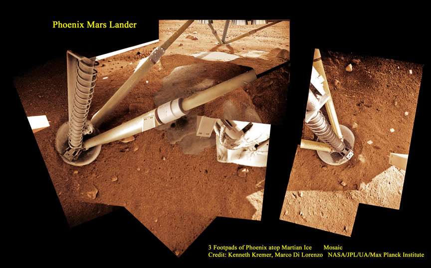
3 Footpads of Phoenix Mars Lander atop Martian Ice. NASA’s Mars InSight spacecraft design is based on the successful 2008 Phoenix lander. This mosaic shows Phoenix touchdown atop Martian ice. Phoenix thrusters blasted away Martian soil and exposed water ice. InSight carries instruments to peer deep into the Red Planet and investigate the nature and size of the mysterious Martian core. Credit: Ken Kremer/kenkremer.com/Marco Di Lorenzo/NASA/JPL/UA/Max Planck Institute
It is funded by NASA’s Discovery Program as well as several European national space agency’s and countries. Germany and France are providing InSight’s two main science instruments; HP3 and SEIS through the Deutsches Zentrum für Luft- und Raumfahrt. or German Aerospace Center (DLR) and the Centre National d’Etudes Spatiales (CNES).
“The seismometer (SEIS, stands for Seismic Experiment for Interior Structure) is from France (built by CNES and IPGP) and the heat flow probe (HP3, stands for Heat Flow and Physical Properties Probe) is from Germany (built by DLR),” Banerdt explained.
SEIS and HP3 are stationed on the lander deck. They will each be picked up and deployed by a robotic arm similar to that flown on Phoenix with some modifications.
Stay tuned here for Ken’s continuing Earth and planetary science and human spaceflight news.