One Moment, Two Worlds

Meridiani Planum on Mars, at 15:00 local Mars time on May 2. Credit: NASA/JPL/Cornell University

[/caption]

The New York Times Lens Blog came up with a great idea: They called it “A Moment in Time,” and asked people everywhere to take a picture on May 2, 2010 15:00 UTC and submit it, to share the variety and complexity of life on our world. Emily Lakdawalla from the Planetary Society saw this and thought, “Why limit it to Earth?” she wrote on the Planetary Blog. “What about Mars? What will Opportunity be doing at 15:00 U.T.C. on May 2?” Emily approached Jim Bell, planetary scientist at Cornell University and lead for the rovers’ Pancam team, who was immediately enthusiastic about the idea of having Opportunity take an image to submit to the “Moment in Time” project.

“My immediate reaction when Emily suggested the idea was ‘Cool!'” Bell told Universe Today. “My second reaction was to wonder whether we’d be able to take the photo at the right time, given the low power situation that Opportunity is in right now. Then my third through tenth reactions were ‘Cool!'”

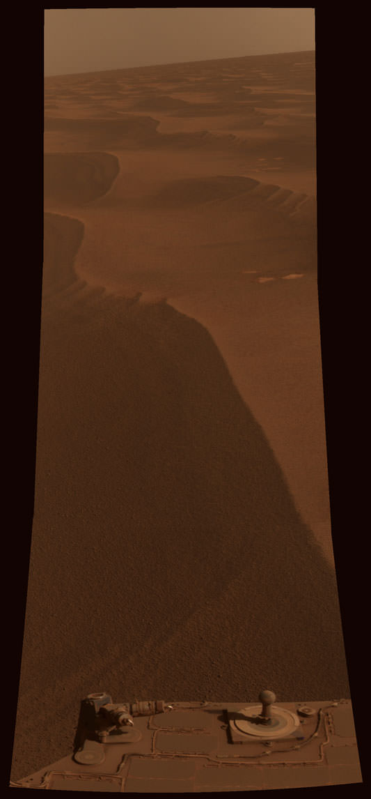
The image has now been posted on the Lens blog, with this caption:

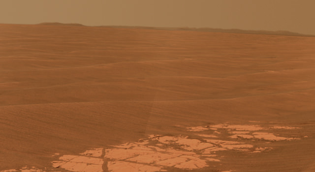
“Two worlds, one sun: while humans’ lives unfolded on Earth, the Mars Exploration Rover Opportunity paused in its southward trek and captured this photomosaic. Dusty, reddish-brown sand dunes stretch to the horizon in a view taken around 15:00 local Mars time on May 2.”

Getting the image from Mars, though was not just as easy as pulling out a camera and taking a picture like people on Earth can do.

“The process of acquiring the image was perhaps just a bit more challenging than “normal” on the rover project,” said Bell, who asked us to remember–lest we all get jaded–how incredibly complex and amazing it is *whenever* we take images with robots on another planet!), — “because we were aiming for a specific time of day, and to try to get the data downlinked on that same day, very soon after taking the data. However, the rover engineering and science teams were very excited about participating in this global photo event, and that support was critical in helping to make it happen.”

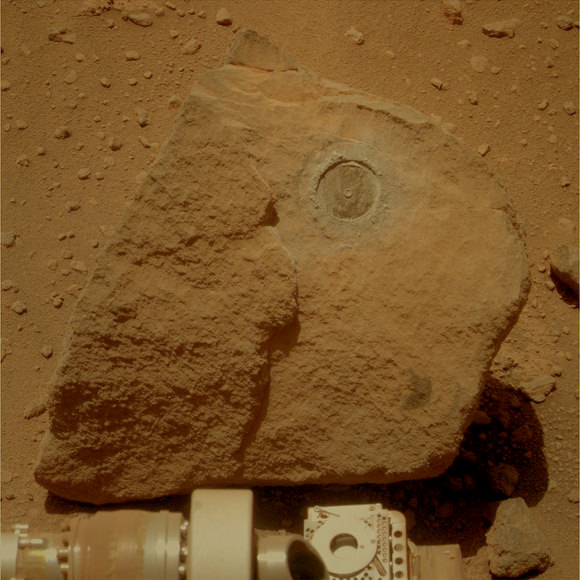
Bell added that the image turned out to be a really lovely shot. The MarsDial (sundial) visible at the bottom of the image on Opportunity is engraved with the words “Two Worlds, One Sun” to mark the unity of Earth and Mars as part of the same solar system.

The timing was “a bit of a fudge” Emily admitted. “Our appointed hour would have been too late for Opportunity in midwinter. Besides, the data began arriving from Mars close to 15:00 U.T.C., so that’s when humans were first able to see the view.”

But the Lens blog folks thought, too, it was a really great idea and decided not to disqualify the picture.

I asked Emily if doing having this image taken at her request was even better than having a request approved for an image from HiRISE, with the “HiWISH” program (public suggestions for the HiRISE camera on the Mars Reconnaissance Orbiter). “It was kind of a HiWish with the rovers!” she said with a smile. “Of course the rover image wouldn’t have happened if the whole rover team wasn’t excited about participating. But it’s important to remind people that those rovers, and all the other spacecraft, and all the people who support them, are out there working hard every day to bring back the data.”

Indeed – wonderful idea, Emily, and great execution on the rover team’s part, making the Mars rovers even more endearing to us Martian wannabes here on Earth.

See the image on the Lens Blog, Emily’s description on the Planetary Blog, and the Mars Rover website.

Opportunity’s Long and Winding Road to Endeavour Crater

Opportunity's view of the far-off rim of Endeavour Crater. Credit: NASA/JPL-Caltech/Cornell University

[/caption]

Back in September of 2008, Mars Exploration Rover Principal Investigator Steve Squyres announced the Opportunity rover would head out to a large, faraway crater named Endeavour, and Squyres said he hoped to one day see the view from the rim. Well, Oppy has now provided an improved view OF the rim: off in the distance in the image above are the “Endeavour Hills,” the mounds which surround the perimeter of the crater, about 13 km (8 miles) away, along with the rim of an even more distant crater, Iazu, on the right.

As the crow flies, Endeavour is about 12 km away from Oppy’s starting point in 2008, Victoria Crater. But while the intrepid rover has already traveled 7 km towards Endeavour, it still has 12 km to go, as the route chosen to avoid potentially hazardous dune fields is more like 19km, as presently charted, said Guy Webster at JPL. You can see an example of Opportunity’s circuitous driving below.

Opportunity's tracks show how the rover avoided driving through potentially dangerous sand dunes. Credit: NASA/JPL/U of AZ

The original target timing for Opportunity reaching Endeavour was about two years, but since the science team has had the rover spend several weeks stopping at interesting targets of study along the way, the rover will definitely not make it to Endeavour by September 2010. It might take another year, or even two.

Additionally, it is now winter on Mars, and according to A.S.J. Rayl’s Rover Update from the Planetary Society, Opportunity is now roving for only about 30 minutes at a time, which enables it to cover only 30-to-50 meters on a drive sol. And, the rover is also taking Martian days off to re-charge its batteries. Record cold temps this winter (down to -37 C) on Mars is slowing the aging rover.

But back in March Oppy reached 20 kilometers (12.43 miles) of total driving in its 74 months on Mars. Pretty amazing for a piece of hardware that was supposed to last six months and drive about 600 meters. Later this month, Oppy will surpass the Viking Lander 1’s record of 6 years and 116 days to become the longest-lived robot on Mars. The Spirit rover has already surpassed that record, but it is unknown if the rover is only hibernating and we’ll hear from it when it warms up again, or if Spirit is no longer with us (sniff!).

Endeavour Crater is 21 kilometers (13 miles) in diameter, which is about 25 times wider than Victoria crater. The view in the top image is an area about 140 kilometers (about 90 miles) wide.

Orbital view of Opportunity's location from THEMIS. mage Credit: NASA/JPL-Caltech/Arizona State University

This view shows a top-down look at the area from orbit, and is a mosaic of daytime infrared images taken by the Thermal Emission Imaging System (THEMIS) camera on NASA’s Mars Odyssey orbiter.

Additionally, a new gif “movie” was released this week showing how Oppy emerged from Victoria crater about a year and a half ago. Click here to see it.

Sources: JPL, Mars Rover homepage, Planetary Society

MRO Sees Opportunity on the Edge of Concepcion Crater (and more!)

Opportunity at the Edge of Concepción Crater (ESP_016644_1780) Opportunity at the Edge of Concepción Crater. Credit: NASA/JPL/University of Arizona

[/caption]
It has been a while since I’ve posted a batch of new images from the Mars Reconnaissance Orbiter HiRISE camera, and what a treat when I saw what had just been released! This image shows the Mars Exploration Rover Opportunity perched on the edge of Concepción Crater in Meridiani Planum, Mars. This image was taken by HiRISE on February 13, 2010, on sol 2153 of Opportunity’s mission on Mars. If you look closely, you can see rover tracks in the ripples to the north and northwest of the rover! Wow! See below for a wonderful colorized close-up version by Stu Atkinson that shows the tracks very clearly. Scientists use these high-resolution images (about 25 cm/pixel) to help navigate the rover. In addition, rover exploration of areas covered by such high-resolution images provides “ground truth” for the orbital data. Oppy has moved along from Concepcion and is now heading towards a set of twin craters. You can check out Stu’s blog Road to Endeavour to see what Opportunity is seeing these days. One milestone (meterstone?) Oppy recently reached was hitting 20 km on her odometer and she seems to continue to be in great operating condition. Go Opportunity! Click here to be able to download larger versions of the image.

Tracks by the Opportunity rover, as seen by HiRISE, color version by Stu Atkinson. Credit: NASA/JPL/U of AZ

Signs of Aeolian and Periglacial Activity at Vastitas Borealis Credit: NASA/JPL/University of Arizona

This image is interesting because of all the interesting different aspects you can find if you look closely. The surface must be relatively young because there are no recent impact craters. There are numerous dust devil tracks crisscrossing across the image. Plus, there are polygon features in the soil – the same features seen around the Phoenix lander area which are produced by repeated expansion and contraction of the soil-ice mixture due to seasonal temperature changes. This is the Vastitas Borealis region on Mars’ northern plains.

Another interesting feature is the circle of boulders that appears on the right side. Is there an impact crater buried under shifting Martian sand? A visit by a rover or human could tell us for sure.

The image covers approximately 400 x 250 meters (350 x 225 yards).

Layers and Dark Debris in Melas Chasma (PSP_002419_1675) Layers and Dark Debris in Melas Chasma Credit: NASA/JPL/University of Arizona

This is an impressive looking region in Melas Chasma. Scientists say the layers are sedimentary in origin, but there are many processes that could have deposited them, such as volcanic airfall from explosive eruptions, or dust-size particles settling out of the atmosphere due to cyclic changes, and deposition in standing bodies of water.

See more great images at the HiRISE website.

Opportunity’s Vacation at Marquette Island

Opportunity leaves a mark on the Marquette Island rock on Mars. Credit: NASA/JPL/U of AZ, colorization by Stuart Atkinson

[/caption]
Caption: Opportunity leaves a mark on the Marquette Island rock on Mars. Credit: NASA/JPL/U of AZ, colorization by Stuart Atkinson

The Opportunity Mars rover has been sitting by a rock called Marquette Island since early November 2009. The stay has given the rover a bit of a respite from the “pedal to the metal” driving regimen in its attempt to get to faraway Endeavour Crater. But Oppy hasn’t been just soaking in the rays, or kicking back doing nothing. She’s been conducting a thorough examination of the rock, and on Sol 2110 (Dec. 24, 2009), Oppy’s Rock Abrasion Tool dug in and left a mark on Marquette Island, a 1.5 millimeters (0.06 inch) hole. Then subsequent observations of the hole were made by the microscopic imager, to create a close-up mosaic of the innards of the rock, and the Mössbauer spectrometer was positioned on a different rock target for a long integration. Stu Atkinson created this colorized version of Oppy’s latest look at Marquette. After the rover hits the dusty trail again, will humans ever see Marquette Island again?

Stu has a few thoughts on that: “In a hundred years this rock will be on display in the Museum of Mars – just down the hall from the “MER Gallery” where Spirit and Oppy are displayed in all their restored glory,” Stu told me, “and there’ll be an attendant on duty beside it all the time, to stop tall, pale-skinned martian kids on school trips from leaning over the barrier and poking their dirty, sticky fingers into the hole Oppy ratted in it.”

Ah, yes! I’ve always loved Stu’s optimism! Check out more of his thoughts on his blog, Cumbrian Sky.

But back to the here an now, the plan ahead for Oppy is to collect an alpha particle X-ray spectrometer (APXS) spectrum and a MB spectrum from the RAT hole, before resuming the drive toward Endeavour crater. Obviously, the science team must find Marquette Island quite interesting to spend so much time there, and it will be interesting to hear the results of the observations.

As of Sol 2110 (Dec. 24, 2009), Opportunity’s solar-array energy production was 315 watt-hours with an atmospheric opacity (tau) of 0.491 and a dust factor of 0.509. Total odometry was 18,927.56 meters (11.76 miles).

Source: Mars Rover website