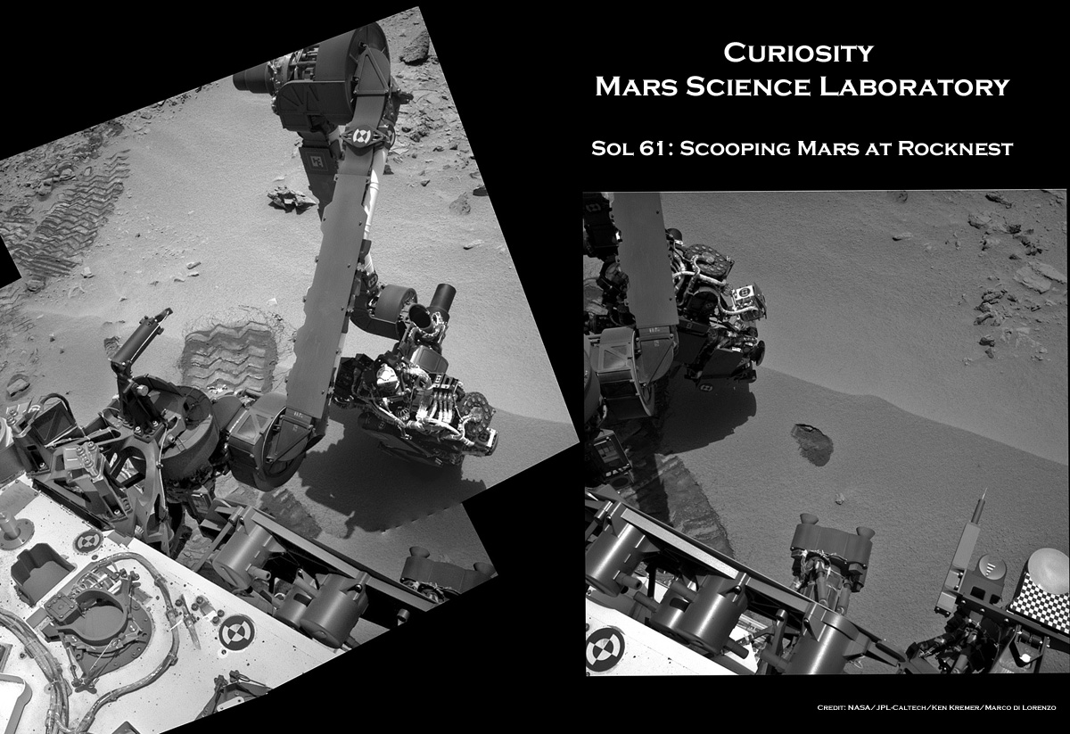
Image Caption: Scooping Mars at ‘Rocknest’ mosaic shows a before and after view of the spot where Curiosity dug up her 1st Martian soil sample on Sol 61 (Oct 7. 2012). Navcam camera mosaic at left shows the arm at work during scooping operations. Image at right shows the tiny scooped trench measuring about 1.8 inches (4.5 centimeters) wide. See NASA JPL scooped sample vibration video below. Credit: NASA/JPL-Caltech/Ken Kremer/Marco Di Lorenzo
“Here’s the scoop: I like my regolith shaken!” tweeted NASA’s Curiosity Mars rover a short while ago in a nod to the 50th anniversary of the premiere of the 1st James Bond action flick.
And the “proof” is in the video as they say. See below a short NASA video clip showing the 1st Martian material collected using the small table spoon sized scoop on Curiosity’s robotic arm and subsequently being vibrated inside the scoop after it was lifted from the ground of Gale Crater this past weekend on Sol 61, Oct. 7, 2012.
Scooping Mars at ‘Rocknest’ mosaic above shows a before and after view of the spot where Curiosity was working at on Sol 61.
“So excited to dig in! One scoop of regolith ripple, coming right up!” she tweeted in the midst of the action.
Video Caption: This 256 frame video clip of Mastcam images shows the 1st sample of Martian material being vibrated inside Curiosity’s table spoon sized scoop on Oct. 7, 2012. Credit: NASA/JPL-Caltech/MSSS
Yeah baby ! Just as the rover’s science and engineers announced last week, the 6 wheeled mega robot Curiosity scored a major success by scooping up her very first sample of windblown Martian sand from the ‘Rocknest’ ripple she arrived at just last week.
The plan ahead is to use the collected “Red Planet” material to cleanse the interior of the rover’s sample-handling system of a residual layer of oily contamination of “Home Planet” material that could interfere with unambiguously interpreting the results.
For sure the science team doesn’t want any false positives with respect to any potential detection of the long sought organic compounds that could shed light on whether a habitant supporting Martian microbes ever existed in the past or present.
The newly collected material will be vibrated at 8 G’s and then be fed into Curiosity’s Collection and Handling for In-Situ Martian Rock Analysis (CHIMRA) device on the robotic arm turret.
Curiosity’s motorized scoop measures 1.8 inches (4.5 centimeters) wide, 2.8 inches (7 centimeters) long. The images reveal the scoop left behind a small hole about 1.8 inches (4.5 centimeters) wide.
Image Caption: Sol 61 Navcam raw image shows the hole dug up by Curioisty’s scoop on Oct. 7, 2012 Credit: NASA/JPL-Caltech
Image Caption: Mastcam 100 telephoto close up image of Rocknest trench on Sol 61. Credit: NASA/JPL-Caltech/MSSS
At last week’s Oct. 4 media briefing, the rover team said they would make three deliveries of scooped soil to cleanse out the sample acquisition system over the next two week or so before pouring sieved Mars material into the SAM and Chemin analytical chemistry labs on the rover’s deck for detailed evaluation of the elemental and mineralogical composition.
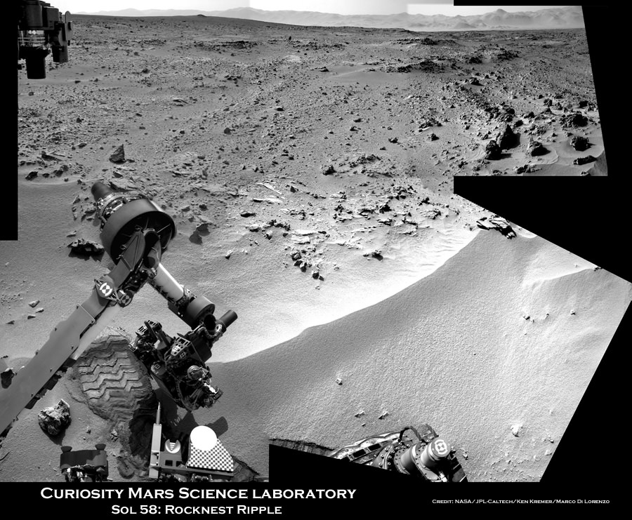
Image caption: Context view of Curiosity working at ‘Rocknest’ Ripple. Curiosity’s maneuvers robotic arm for close- up examination of ‘Rocknest’ ripple site and inspects sandy material at “bootlike” wheel scuff mark with the APXS (Alpha Particle X-Ray Spectrometer) and MAHLI (Mars Hand Lens Imager) instruments positioned on the rotatable turret at the arm’s terminus. Mosaic was stitched together from Sol 57 & 58 Navcam raw images and shows the arm extended to fine grained sand ripple in context with the surrounding terrain and eroded rim of Gale Crater rim on the horizon. Rocknest patch measures about 8 feet by 16 feet (2.5 meters by 5 meters).See NASA JPL test scooping video below. Credit: NASA/JPL-Caltech/Ken Kremer/Marco Di Lorenzo
NASA’s Curiosity rover is set to scoop up her 1st sample of Martian soil this weekend at a soil patch nicknamed ‘Rocknest’ -see our context mosaic above – and will funtion as a sort of circulatory system cleanser for all the critical samples to follow. This marks a major milestone on the path to delivering Mars material to the sample acquisition and processing system for high powered analysis by the robots chemistry labs and looking for the ingredients of life, said the science and engineering team leading the mission at a media briefing on Thursday, Oct 4.
Since landing on the Red Planet two months ago on Aug. 5/6, Curiosity has trekked over 500 yards eastwards across Gale crater towards an intriguing area named “Glenelg” where three different types of geologic terrain intersect.
This week on Oct. 2 (Sol 56), the rover finally found a wind driven patch of dunes at ‘Rocknest’ with exactly the type of fine grained sand that the team was looking for and that’s best suited as the first soil to scoop and injest into the sample acquisition system.
See NASA JPL earthly test scooping video below to visualize how it works:
“We now have reached an important phase that will get the first solid samples into the analytical instruments in about two weeks,” said Mission Manager Michael Watkins of NASA’s Jet Propulsion Laboratory in Pasadena, Calif.
The rover used its wheels to purposely scuff the sand and expose fresh soil – and it sure looked like the first human “bootprint” left on the Moon by Apollo 11 astronauts Neil Armstrong and Buzz Aldrin.
Curiosity will remain at the “Rocknest” location for the next two to three weeks as the team fully tests and cleans the walls of most of the sample collection, handling and analysis hardware – except for the drilling equipment – specifically to remove residual contaminants from Earth.
Image caption: ‘Rocknest’ From Sol 52 Location on Sept. 28, 2012, four sols before the rover arrived at Rocknest. The Rocknest patch is about 8 feet by 16 feet (1.5 meters by 5 meters). Credit: NASA/JPL-Caltech/MSSS
The purpose of this initial scoop is to use the sandy material to thoroughly clean out, rinse and scrub all the plumbing pipes, chambers, labyrinths and interfaces housed inside the complex CHIMRA sampling system and the SAM and CheMin chemistry labs of an accumulation of a very thin and fine oily layer that could cause spurious, interfering readings when the truly important samples of Martian soil and rocks are collected for analysis starting in the near future.
The scientists especially do not want any false signals of organic compounds or other inorganic materials and minerals stemming from Earthly contamination while the rover and its instruments were assembled together and processed for launch.
“Even though we make this hardware super squeaky clean when it’s delivered and assembled at the Jet Propulsion Laboratory, by virtue of its just being on Earth you get a kind of residual oily film that is impossible to avoid,” said Daniel Limonadi of JPL, lead systems engineer for Curiosity’s surface sampling and science system. “And the Sample Analysis at Mars instrument is so sensitive we really have to scrub away this layer of oils that accumulates on Earth.”
The team plans to conduct three scoop and rinse trials – dubbed rinse and discard – of the sample acquisition systems. So it won’t be until the 3rd and 4th soil scooping at Rocknest that a Martian sample would actually be delivered for entry into the SAM and CheMin analytical chemistry instruments located on the rover deck.
“What we’re doing at the site is we take the sand sample, this fine-grained material and we effectively use it to rinse our mouth three times and then kind of spit out,” Limonadi said. “We will take a scoop, we will vibrate that sand on all the different surfaces inside CHIMRA to effectively sand-blast those surfaces, then we dump that material out and we rinse and repeat three times to finish cleaning everything out. Our Earth-based testing has found that to be super effective at cleaning.”
Limondi said the first scooping is likely to be run this Saturday (Oct 6) on Sol 61, if things proceed as planned. Scoop samples will be vibrated at 8 G’s to break them down to a very fine particle size that can be easily passed through a 150 micron sieve before entering the analytical instruments.
The team is being cautious, allowing plenty of margin time and will not proceed forward with undue haste.
“We’re being deliberately slow and incredibly careful,” said Watkins. “We’re taking a lot of extra steps here to make sure we understand exactly what’s going on, that we won’t have to do every time we do a scoop in the future.”
Curiosity’s motorized, clamshell-shaped scoop measures 1.8 inches (4.5 centimeters) wide, 2.8 inches (7 centimeters) long, and can sample to a depth of about 1.4 inches (3.5 centimeters). It is part of the CHIMRA collection and handling device located on the tool turret at the end of the rover’s arm.
“The scoop is about the size of an oversized table spoon,” said Limonadi.
Image caption: Curiosity extends 7 foot long arm to investigate ‘Bathurst Inlet’ rock outcrop with the MAHLI camera and APXS chemical element spectrometer in this mosaic of Navcam images assembled from Sols 53 & 54 (Sept. 29 & 30, 2012). Mount Sharp, the rover’s eventual destination is visible on the horizon. Thereafter the rover drove more than 77 feet (23 meters) eastwards to reach the ‘Rocknest’ sand ripple. Credit: NASA/JPL-Caltech/Ken Kremer/Marco Di Lorenzo
During the lengthy stay at Rocknest, the rover will conduct extensive investigations of the surrounding rocks and terrain with the cameras, ChemCam laser, DAN, RAD as well as weather monitoring with the REMS instrument.
After finishing her work at Rocknest, Curiosity will resume driving eastward to Glenelg, some 100 meters (yards) away where the team will select the first targets and rock outcrops to drill, sample and analyze.
At Glenelg and elsewhere, researchers hope to find more evidence for the ancient Martian stream bed they discovered at rock outcrops at three different locations that Curiosity has already visited.
Curiosity is searching for organic molecules and evidence of potential habitable environments to determine whether Mars could have supported Martian microbial life forms, past or present.
SpaceX’s Elon Musk with the Falcon rocket. Credit: SpaceX
You can now tell everyone that SpaceX CEO Elon Musk is a close personal friend and that you are going to hang out with him on Friday. A Google+ Hangout, that is. Musk and NASA Administrator Charlie Bolden will be part of a G+ Hangout, and will answer questions submitted by viewers. They will also discuss the upcoming launch of SpaceX’s first contracted cargo resupply flight to the International Space Station. The Hangout will take place on Friday, October 5, 2012 from 17:00-17:30 UTC (1-1:30 p.m. EDT). SpaceX’s Falcon 9 rocket and its Dragon cargo spacecraft are scheduled to lift off at 00:35 UTC on Monday, October 8 (8:35 p.m. EDT, Sunday, Oct. 7) from at Cape Canaveral Air Force Station in Florida.
Bolden and Musk will talk about the flight, which will be the first of 12 contracted for NASA by SpaceX to resupply the space station. Followers on Twitter may ask a question in advance of or during the event using the hashtag #askNASA. On NASA Facebook and Google+, a comment thread will open for questions on the morning of the event. To join the hangout, visit the NASA’s Google+ page.
Frame from a simulation of the merger of two black holes and the resulting emission of gravitational radiation (NASA/C. Henze)
The short answer? You get one super-SUPERmassive black hole. The longer answer?
Well, watch the video below for an idea.
This animation, created with supercomputers at the University of Colorado, Boulder, show for the first time what happens to the magnetized gas clouds that surround supermassive black holes when two of them collide.
The simulation shows the magnetic fields intensifying as they contort and twist turbulently, at one point forming a towering vortex that extends high above the center of the accretion disk.
This funnel-like structure may be partly responsible for the jets that are sometimes seen erupting from actively feeding supermassive black holes.
The simulation was created to study what sort of “flash” might be made by the merging of such incredibly massive objects, so that astronomers hunting for evidence of gravitational waves — a phenomenon first proposed by Einstein in 1916 — will be able to better identify their potential source.
Gravitational waves are often described as “ripples” in the fabric of space-time, infinitesimal perturbations created by supermassive, rapidly rotating objects like orbiting black holes. Detecting them directly has proven to be a challenge but researchers expect that the technology will be available within several years’ time, and knowing how to spot colliding black holes will be the first step in identifying any gravitational waves that result from the impact.
In fact, it’s the gravitational waves that rob energy from the black holes’ orbits, causing them to spiral into each other in the first place.
“The black holes orbit each other and lose orbital energy by emitting strong gravitational waves, and this causes their orbits to shrink. The black holes spiral toward each other and eventually merge,” said astrophysicist John Baker, a research team member from NASA’s Goddard Space Flight Center. “We need gravitational waves to confirm that a black hole merger has occurred, but if we can understand the electromagnetic signatures from mergers well enough, perhaps we can search for candidate events even before we have a space-based gravitational wave observatory.”
The video below shows the expanding gravitational wave structure that would be expected to result from such a merger:
If ground-based telescopes can pinpoint the radio and x-ray flash created by the mergers, future space telescopes — like ESA’s eLISA/NGO — can then be used to try and detect the waves.
Image Caption: Antares Rocket At Wallops Flight Facility Launch Pad. Orbital Sciences Corporation’s Antares rocket at the launch pad at NASA’s Wallops Flight Facility. In a few months, Antares is scheduled to launch a cargo delivery demonstration mission to the International Space Station as part of NASA’s Commercial Orbital Transportation Services (COTS) program. Credit: NASA
At long last, Orbital Sciences Corporation has rolled their new commercially developed Antares medium class rocket to the nation’s newest spaceport – the Mid-Atlantic Regional Spaceport (MARS) at Wallops Island,Va – and commenced on pad operations as of Monday, Oct 1.
The long awaited rollout marks a key milestone on the path to the maiden test flight of the Antares, planned to blast off before year’s end if all goes well.
This is a highly noteworthy event because Antares is the launcher for Orbital’s unmanned commercial Cygnus cargo spacecraft that NASA’s hopes will reestablish resupply missions to the International Space Station (ISS) lost with the shuttle’s shutdown.
“MARS has completed construction and testing operations on its launch complex at Wallops Island, the first all-new large-scale liquid-fuel launch site to be built in the U.S. in decades,” said David W. Thompson, Orbital’s President and Chief Executive Officer.
“Accordingly, our pad operations are commencing immediately in preparation for an important series of ground and flight tests of our Antares medium-class launch vehicle over the next few months. In fact, earlier today (Oct. 1), an Antares first stage test article was transported to the pad from its final assembly building about a mile away, marking the beginning of full pad operations.”
Antares 1st stage rocket erected at Launch Pad 0-A at the Mid-Atlantic Regional Spaceport (MARS) at NASA Wallops Flight Facility in Virginia. Credit: NASA
In about 4 to 6 weeks, Orbital plans to conduct a 30 second long hot fire test of the first stage, generating a total thrust of 680,000 lbs. If successful, a full up test flight of the 131 foot tall Antares with a Cygnus mass simulator bolted on top is planned for roughly a month later.
The first commercial resupply mission to the ISS by SpaceX (CRS-1) is now set to lift off on Oct. 7 from Cape Canaveral, Florida.
The 700,000 lb thrust Antares first stage is powered by a pair of Soviet era NK-33 engines built during the 1960 and 1970’s as part of Russia’s ill-fated N-1 manned moon program. The engines have since been upgraded and requalified by Aerojet Corp. and integrated into the Ukrainian built first stage rocket as AJ-26 engines.
Image Caption: Antares first stage arrives on the pad at NASA_Wallops on Oct. 1. First stage approaching adapter ring on the right. Credit: NASA
NASA awarded contracts to Orbital Sciences Corp and SpaceX in 2008 to develop unmanned commercial resupply systems with the goal of recreating an American capability to deliver cargo to the ISS which completely evaporated following the forced retirement of NASA’s Space Shuttle orbiters in 2011 with no follow on program ready to go.
“Today’s (Oct. 1) rollout of Orbital’s Antares test vehicle and the upcoming SpaceX mission are significant milestones in our effort to return space station resupply activities to the United States and insource the jobs associated with this important work,” said NASA Associate Administrator for Communications David Weaver. “NASA’s commercial space program is helping to ensure American companies launch our astronauts and their supplies from U.S. soil.”
The public will be invited to watch the Antares blastoff and there are a lot of locations for spectators to gather nearby for an up close and personal experience.
“Antares is the biggest rocket ever launched from Wallops,” NASA Wallops spokesman Keith Koehler told me. “The launches will definitely be publicized.”
The southern portion of Mercury’s Vivaldi basin and outlying rugged terrain
Named for the 17th-century Venetian composer, the southern half of Mercury’s Vivaldi basin is seen in this image acquired on August 26 by NASA’s MESSENGER spacecraft. The 213-km (132-mile) -wide crater’s smooth floor is contrasted by the incredibly rugged terrain beyond its outermost ring — a result of the ejected material that was flung out from the impact site and emphasized by the low angle of illumination.
The floor of the crater remained relatively smooth due to molten material that erupted in the wake of the impact event, flooding the basin.
Recent findings from the MESSENGER mission have revealed variations in Mercury’s surface composition due to volcanism that occurred at different times, as well as a surprising concentration of elements like magnesium and sulfur — much more so than any of the other terrestrial planets.
In results to be published in the Journal of Geophysical Research, scientists report that Mercury’s volcanic smooth plains differ in composition from older surrounding terrains. The older terrain has higher ratios of magnesium to silicon, sulfur to silicon, and calcium to silicon, but lower ratios of aluminum to silicon, suggesting that the smooth plains material erupted from a magma source that was chemically different from the source of the material in the older regions, according to Shoshana Weider of the Carnegie Institution of Washington, the lead author on the paper.
Mercury’s surface was also found to be high in magnesium and sulfur-enriched minerals.
“None of the other terrestrial planets have such high levels of sulfur. We are seeing about ten times the amount of sulfur than on Earth and Mars,” Weider said. “In terms of magnesium, we do have some materials on Earth that are high in magnesium. They tend to be ancient volcanic rocks that formed from very hot lavas. So this composition on Mercury tells us that eruptions of high-temperature lavas might have formed these high-magnesium materials.”
The data was gathered with MESSENGER’s X-Ray Spectrometer (XRS) — one of two instruments designed to measure the abundances of many key elements in the top 2mm of Mercury’s crust. XRS detects emissions from elements in the 1-10 kiloelectron-volt (keV) range – specifically, magnesium, aluminum, silicon, sulfur, calcium, titanium, and iron.
Inset image: A global mosaic of Mercury from MESSENGER (2011). Image credits: NASA/Johns Hopkins University Applied Physics Laboratory/Carnegie Institution of Washington
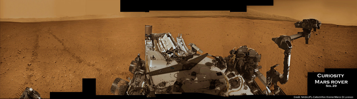
Image Caption: Curiosity at work on Mars inside Gale Crater. Panoramic mosaic showing Curiosity in action with her wheel tracks and the surrounding terrain snapped from the location the rover drove to on Sol 29 (Sept 4). The time lapse imagery highlights post drive wheel tracks at left, movement of the robotic arm from the stowed to deployed position with pointing instrument turret at right with Mt Sharp and a self portrait of Curiosity’s instrument packed deck top at center. This colorized mosaic was assembled from navigation camera (Navcam) images taken over multiple Martian days while stationary beginning on Sol 29. Click to Enlarge. Credit: NASA/JPL-Caltech/Ken Kremer/Marco Di Lorenzo
NASA’s Mega Martian Rover Curiosity is swiftly trekking across the Red Planet’s science rich terrain inside Gale Crater as she approaches the two month anniversary since the daring atmospheric plunge and pinpoint touchdown on Aug. 5/6 beside her eventual destination of the richly layered mountainside of Mount Sharp.
In this ultra short span of time, Curiosity has already fulfilled on her stated goal of seeking the signs of life and potentially habitable environments by discovering evidence for an ancient Martian stream bed at three different locations – at the landing site and stops along her traverse route – where hip deep liquid water once vigorously flowed billions of years ago. Liquid water is a prerequisite for the origin of life.
Curiosity discovered a trio of outcrops of stones cemented into a layer of conglomerate rock – initially at “Goulburn” scour as exposed by the landing thrusters and later at the “Link” and “Hottah” outcrops during the first 40 sols of the mission.
If they find another water related outcrop, Curiosity Mars Science Laboratory (MSL) Project Manager John Grotzinger told me that the robotic arm will be deployed to examine it.
“We would do all the arm-based contact science first, and then make the decision on whether to drill. If we’re still uncertain, then we still have time to deliberate,” Grotzinger told me.
Image caption: Remnants of Ancient Streambed on Mars. NASA’s Curiosity rover found evidence for an ancient, flowing stream on Mars at a few sites, including the rock outcrop pictured here, which the science team has named “Hottah” after Hottah Lake in Canada’s Northwest Territories. It may look like a broken sidewalk, but this geological feature on Mars is actually exposed bedrock made up of smaller fragments cemented together, or what geologists call a sedimentary conglomerate. Scientists theorize that the bedrock was disrupted in the past, giving it the titled angle, most likely via impacts from meteorites. This image mosaic was taken by the 100-millimeter Mastcam telephoto lens on Sol 39 (Sept. 14, 2012). Credit: NASA/JPL-Caltech/MSSS
“This is the first time we’re actually seeing water-transported gravel on Mars. This is a transition from speculation about the size of streambed material to direct observation of it,” said Curiosity science co-investigator William Dietrich of the University of California, Berkeley.
Image Caption: Curiosity conducts 1st contact science experiment at “Jake” rock on Mars. This 360 degree panoramic mosaic of images from Sols 44 to 47 (Sept 20-23) shows Curiosity arriving near Jake rock on Sol 44. The robot then drove closer. Inset image from Sol 47 shows the robotic arm extended to place the science instruments on the rock and carry out the first detailed contact science examination of a Martian rock with the equipment positioned on the turret at the arms terminus. Jake rock is named in honor of recently deceased team member Jake Matijevic. This mosaic was created in tribute to Jake and his outstanding contributions. Click to Enlarge. Credit: NASA/JPL-Caltech/Ken Kremer/Marco Di Lorenzo
The one-ton robot soon departed from her touchdown vicinity at “Bradbury Landing” and set off on a multi-week eastwards traverse to her first science target which the team has dubbed “Glenelg”.
See our panoramic Curiosity mosaics herein showing the rovers movements on various Sols as created by Ken Kremer and Marco Di Lorenzo from NASA raw images.
Curiosity is also now closing in on the spot from which she will reach out with the advanced 7 foot long (2.1 meter) robotic arm to scoop up her very first Martian soil material and deliver samples to the on board chemistry labs.
At a Sept. 27 briefing for reporters, Grotzinger, of Caltech in Pasadena, Calif., said the team hopes to find a suitable location to collect loose, gravelly Martian soil within the next few sols that can be easily sifted into the analytical labs. Curiosity will then spend about 2 or 3 weeks investigating the precious material and her surroundings, before continuing on to Glenelg.
The science team chose Glenelg as the first target for detailed investigation because it sits at the intersection of three distinct types of geologic terrain, affording the researchers the opportunity to comprehensively explore the diverse geology inside the Gale Crater landing site long before arriving at the base of Mount Sharp. That’s important because the rover team estimates it will take a year or more before Curiosity reaches Mount Sharp, which lies some 10 kilometers (6 miles) away as the Martian crow flies.
As of today, Sol 53, Curiosity has driven a total distance of 0.28 mile (0.45 kilometer) or more than ¾ of the way towards Glenelg. Yestersol (Sol 52), the six wheeled robot drove about 122 feet (37.3 meters) toward the Glenelg area and is using visual odometry to assess her progress and adjust for any wheel slippage that could hint at sand traps or other dangerous obstacles.
The longest drive to date just occurred on Sol 50 with the robot rolling about 160 feet (48.9 meters).
Curiosity recently conducted her first detailed rock contact science investigation with the robotic arm at a rock named “Jake”, in honor of Jake Matijevic, a recently deceased MSL team member who played a key and leading role on all 3 generations of NASA’s Mars rovers. See our 360 degree panoramic “Jake rock” mosaic created in tribute to Jake Matijevic.
Curiosity is searching for hydrated minerals, organic molecules and signs of habitats favorable for past or present microbial life on Mars.
Image Caption: “Hottah” water related outcrop. Context mosaic shows location of Hottah” outcrop (bottom right) sticking out from the floor of Gale Crater as imaged by Curiosity Navcam on Sol 38 with Mount Sharp in the background. The Glenelg science target lies in the terrain towards Mt Sharp. This is what an astronaut geologist would see on Mars. Credit: NASA/JPL-Caltech/Ken Kremer/Marco Di Lorenzo
Alluvial Fan Where Water Flowed Downslope. This image shows the topography, with shading added, around the area where NASA’s Curiosity rover landed on Aug. 5 PDT (Aug. 6 EDT). The black oval indicates the targeted landing area for the rover known as the “landing ellipse,” and the cross shows where the rover actually landed.An alluvial fan, or fan-shaped deposit where debris spreads out downslope, has been highlighted in lighter colors for better viewing. On Earth, alluvial fans often are formed by water flowing downslope. New observations from Curiosity of rounded pebbles embedded with rocky outcrops provide concrete evidence that water did flow in this region on Mars, creating the alluvial fan. Credit: NASA/JPL-Caltech/UofA
Dawn image of Vesta showing its nearly circumferential equatorial grooves (NASA/JPL-Caltech/UCLA/MPS/DLR/IDA)
Even though NASA’s Dawn spacecraft has departed Vesta the trove of data it’s gathered about this fascinating little world continues to fuel new discoveries. Most recently, some researchers are suggesting that Vesta’s curious grooves — long, deep troughs that wrap around its equator, noticed immediately after Dawn came within close proximity — are actually features called graben, the results of surface expansion along fault lines.
In Vesta’s case, the faults likely may have come from whatever major collision created the enormous central peak that rises almost three times the height of Mt. Everest from its south pole… and the expansion could be the result of differentiation of its interior — a separation of core, mantle and crust that’s much more planet-like than anything asteroidish.
On smaller asteroids and moons, stress fractures tend to have a “V” shape, cutting inwards to a sharp point. But the troughs on Vesta are more rounded, with a “U” shape that results from surface material slumping downwards as the surface pulls apart. Found on larger worlds like Earth, the Moon, Mars, Mercury — and now possibly Vesta as well — graben are shaped by motions below the crust and not just the splitting of the surface.
The biggest of Vesta’s troughs, Divalia Fossa, is 465 kilometers (289 miles) long, 22 km (13.6 mi) wide and 5 km (3 mi) deep… longer and three times deeper than the Grand Canyon.
Animation of Vesta rotating made from Dawn images and assembled by The Planetary Society’s Emily Lakdawalla
If the researchers are correct and these are indeed graben, rather than just fractures or grooves carved into the surface by another process, Vesta probably had a lot more going on inside it than does your typical asteroid.
“By saying it’s differentiated, we’re basically saying Vesta was a little planet trying to happen,” said Debra Buczkowski of the Johns Hopkins University Applied Physics Laboratory (JHUAPL), lead author of a new paper titled “Large-scale troughs on Vesta: A signature of planetary tectonics” scheduled to be published by the AGU on Sept. 29.
Unlike its big sister Ceres, the largest world among the asteroids and Dawn’s next destination, Vesta isn’t officially classified as a dwarf planet because its shape isn’t spherical enough — a flagrant violation of IAU Planetary Code Regulation No. 2. Rather it’s more flattened, like a walnut. This of course is also likely the result of the impact Vesta sustained at its south pole (which also may be responsible for its rapid 5.35-hour rotation rate, helping to bulge out the equatorial region and possibly even provide an alternate source for the trough “stretch marks”) and so begs the question, was Vesta once a dwarf planet? And if so, does severe reconstruction by an impact event “reclassify” it as something else? What, then? Ex-dwarf planet? A planet-formerly-known-as-dwarf?An undwarf?
I’m sure the IAU is already anticipating the contretemps.
“We have been calling Vesta the smallest terrestrial planet. The latest imagery provides much justification for our expectations. They show that a variety of processes were once at work on the surface of Vesta and provide extensive evidence for Vesta’s planetary aspirations.”
– Chris Russell, Dawn mission principal investigator at UCLA
Read more on the American Geophysical Union’s press release here, and follow the latest from NASA’s Dawn mission here.
A “speckle image” reconstruction of Pluto and its largest moon, Charon (Gemini Observatory/NSF/NASA/AURA)
Real planet, dwarf planet, KBO, who cares? What matters here is that astronomers have created the sharpest image of Pluto ever made with ground-based observations — and developed a new way to verify potential Earth-like exoplanets at the same time.
Here’s how they did it:
After taking a series of quick “snapshots” of Pluto and Charon using a recently-developed camera called the Differential Speckle Survey Instrument (DSSI), which was mounted on the Gemini Observatory’s 8-meter telescope in Hawaii, researchers combined them into a single image while canceling out the noise caused by turbulence and optical aberrations. This “speckle imaging” technique resulted in an incredibly clear, crisp image of the distant pair of worlds — especially considering that 1. it was made with images taken from the ground, 2. Pluto is small, and 3. Pluto is very, very far away.
Less than 3/4 the diameter of our Moon, Pluto (and Charon, which is about half that size) are currently circling each other about 3 billion miles from Earth — 32.245 AU to be exact. That’s a long way off, and there’s still much more that we don’t know than we do about the dwarf planet’s system. New Horizons will fill in a lot of the blanks when it passes close by Pluto in July 2015, and images like this can be a big help to mission scientists who want to make sure the spacecraft is on a safe path.
“The Pluto-Charon result is of timely interest to those of us wanting to understand the orbital dynamics of this pair for the 2015 encounter by NASA’s New Horizons spacecraft,” said Steve Howell of the NASA Ames Research Center, who led the Gemini imaging study.
In addition, the high resolution achievable through the team’s speckle imaging technique may also be used to confirm the presence of exoplanet candidates discovered by Kepler. With an estimated 3- to 4-magnitude increase in imaging sensitivity, astronomers may be able to use it to pick out the optical light reflected by a distant Earth-like world around another star.
Speckle imaging has been used previously to identify binary star systems, and with the comparative ability to “separate a pair of automobile headlights in Providence, RI, from San Francisco, CA” there’s a good chance that it can help separate an exoplanet from the glare of its star as well.
Main image: the first speckle reconstructed image for Pluto and Charon from which astronomers obtained not only the separation and position angle for Charon, but also the diameters of the two bodies. North is up, east is to the left, and the image section shown is 1.39 arcseconds across. Resolution of the image is about 20 milliarcseconds rms. Credit: Gemini Observatory/NSF/NASA/AURA. Inset: the Gemini North telescope on the summit of Mauna Kea. (Gemini Observatory)
In this artist’s concept, the Orion MPCV is docked to a habitat; an astronaut exits the spacecraft to conduct an EVA. Credit: NASA
Over the weekend, The Orlando Sentinel reported that NASA is considering building a hovering outpost beyond the Moon at L-2 (Lagrangian point 2) that will be a ‘gateway’ to serve as a point for launching human missions to Mars and asteroids. The buzz among the space-related social medias ranged from “this is the greatest idea ever” to “this is make-work for the Space Launch System, (NASA’s new rocket.)” The newspaper’s report cited a White House briefing given in September by NASA Administrator Charlie Bolden, but said “it’s unclear whether it has the administration’s support. Of critical importance is the price tag, which would certainly run into the billions of dollars.”
As always, money is the real issue with any grand ideas that anyone at NASA may have.
And NASA has now officially responded to the The Sentinel’s report and said… well, actually they didn’t really say much at all. Here’s the NASA statement:
“NASA is executing President Obama’s ambitious space exploration plan that includes missions around the moon, to asteroids, and ultimately putting humans on Mars. There are many options – and many routes – being discussed on our way to the Red Planet. In addition to the moon and an asteroid, other options may be considered as we look for ways to buy down risk – and make it easier – to get to Mars. We have regular meetings with OMB (Office of Management and Budget), OSTP(Office of Science and Technology) , Congress, and other stakeholders to keep them apprised of our progress on our deep space exploration destinations. This concept is a part of the Voyages document that we mentioned in an earlier Update posted on NASA.gov in June: http://go.nasa.gov/NASAvoyages.” Refer to page 26 of the chapter titled, “Habitation and Destination Capabilities.”
And so NASA does not deny they are looking into building such a base, and in the document mentioned above, they do provide some interesting details about why exploring cis-lunar space would be important: for scientific reasons, for technological and economic growth and to pave the way for future exploration.
And so, what would a space station beyond the Moon be like? The Sentinel suggested it could be built in a budget-conscious way using parts left over from the International Space Station and be placed at what’s known as the Earth-Moon Lagrange Point 2, a spot about 38,000 miles beyond the far side of the Moon and 277,000 miles from Earth where the gravitational pull of Earth and the Moon are at equilibrium, so that a spacecraft could basically “hover” in a fixed spot.
In the document, NASA says the habitat they are designing combines technologies to accommodate a crew of at least four, potentially six for a mission to Mars. The in-space version of the habitat will require docking systems for crew transportation vehicles, and it could be used in cis-lunar space as a Lagrange point facility, or in transit to deep-space destinations, or near a NEA.
Artist’s concept of an inflatable cis-lunar facility, or Lagrange gateway. Credit: NASA
They call the L-2 Gateway base an “ISS Stepping Stone,” saying that the ISS is an invaluable resource for researching and testing exploration capabilities in space, and it may inspire future space station concepts.
“As NASA looks to explore beyond LEO, the agency is considering how a facility in cis-lunar space, potentially stationed at an Earth-Moon Lagrange point, could support research, testing, and astronomical observation, as well as provide a staging point for exploration missions. Such a facility, also known as a Lagrange gateway, would build upon ISS hardware and experience, and would serve as an initial in-space habitat, providing a basis for future long-duration habitation developments.”
Could this ‘Gateway’ idea really fly?
The Sentinel says that from NASA’s perspective, the outpost solves several problems.
“It gives purpose to the Orion space capsule and the Space Launch System rocket, which are being developed at a cost of about $3 billion annually. It involves NASA’s international partners, as blueprints for the outpost suggest using a Russian-built module and components from Italy. And the outpost would represent a baby step toward NASA’s ultimate goal: human footprints on Mars.” — Orlando Sentinel
The report doesn’t mention budget or costs, and if the federal government cuts budgets in the name of deficit reduction, it is very unlikely that NASA will get more money — and it likely could get less – than the current budget of $17.7 billion.
If the past is any indication of the future, this report may wind up like Werner von Braun’s 1950’s vision of getting humans to Mars: a report that future generations look back on and say, “wish we could have done that, and why can’t we do that now?”