From One Laurel to Another: a Letter from Columbia

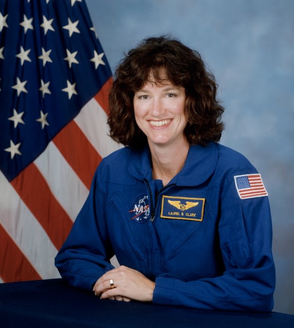
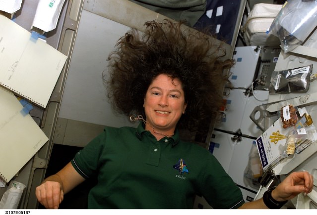
STS-107 Mission Specialist Laurel B. Clark (NASA)

On this Day of Remembrance, February 1, 2013, NASA will mark the 10th anniversary of the STS-107 Columbia accident with a wreath-laying ceremony at the astronaut memorial in Arlington National Cemetery, paying tribute to the lost crews of Columbia, Challenger and Apollo 1, as well as other space explorers and NASA colleagues who have passed on. Most of us have our own personal memories of the tragic events that took the lives of these brave few who risked everything in the name of exploration, knowledge, and discovery, and I’ve agreed to share one person’s connection to the Columbia crew.

Laurel Nendza, a fellow space blogger over on that social media site that begins with F and rhymes with “acebook” has a particular connection with STS-107 Mission Specialist Laurel B. Clark… if only that they both love space and share the same first name. Still, it’s enough to hang one’s heart on, and Laurel (the blogger) recently posted a particularly touching note that was sent by Laurel (the astronaut) to her family just before Columbia headed back on its ill-fated return trip home. Here’s Laurel’s (and Laurel’s) story:

On February 1, 2003, the seven [STS-107] crew members were lost with the Space Shuttle Columbia over North Texas during the shuttle’s re-entry. They were brave men and women who gave their lives for space exploration.

s107e05167One member has always stood out to me. Her name was Laurel Clark. She would probably agree that growing up there were never any other Laurels around. She may at one time hated her name like I did, only to realize she was actually cool and unique because she was the only one around with that name. But Laurel is not just a name, it’s a personality trait. I know a handful of Laurels (mostly from Facebook) and we all seem to have the same things in common. Most of us always have had deep compassion for animals, the Earth, and the sky above us. Laurel Clark was no different.

What was different about Laurel Clark is that she was just a handful of people on Earth, EVER, who actually achieved what we all dream. She was an astronaut and got to go to outer space. She had the privilege (that she worked very hard to get) to witness our pale blue dot from above as well as breathtaking auroras, lightning, and the Sun and Moon rising.

Before she departed to her last shuttle flight home she sent an email to her family and close friends. She told them of every incredible, awe-inspiring moment she had been a part of. She and the other 6 members who perished in the Columbia tragedy are true heroes and inspirations to all who came after her. They are my inspiration. My dream is to also be able to see my beautiful planet from above, and to see the stars shine bright in all their glory.

s107e05006She was the first Laurel in space, who knows? Maybe one day I will be the next?

Rest in peace all the brave crew of the Shuttle Columbia.

Below is Laurel Clark’s last message to her loved ones on Earth:

“Hello from above our magnificent planet Earth. The perspective is truly awe-inspiring. This is a terrific mission and we are very busy doing science round the clock. Just getting a moment to type e-mail is precious so this will be short, and distributed to many who I know and love.

I have seen some incredible sights: lightning spreading over the Pacific, the Aurora Australis lighting up the entire visible horizon with the cityglow of Australia below, the crescent moon setting over the limb of the Earth, the vast plains of Africa and the dunes on Cape Horn, rivers breaking through tall mountain passes, the scars of humanity, the continuous line of life extending from North America, through Central America and into South America, a crescent moon setting over the limb of our blue planet. Mount Fuji looks life a small bump from up here, but it does stand out as a very distinct landmark.

Magically, the very first day we flew over Lake Michigan and I saw Wind Point (Wisconsin) clearly. Haven’t been so lucky since. Every orbit we go over a slightly different part of the Earth. Of course, much of the time I’m working back in Spacehab and don’t see any of it. Whenever I do get to look out, it is glorious. Even the stars have a special brightness.

I have seen my ‘friend’ Orion several times. Taking photos of the earth is a real challenge, but a steep learning curve. I think I have finally gotten some beautiful shots the last 2 days. Keeping my fingers crossed that they’re in sharp focus.

My near vision has gotten a little worse up here so you may have seen pics/video of me wearing glasses. I feel blessed to be here representing our country and carrying out the research of scientists around the world. All of the experiments have accomplished most of their goals despite the inevitable hiccups that occur when such a complicated undertaking is undertaken. Some experiments have even done extra science. A few are finished and one is just getting started today.

s107e05745

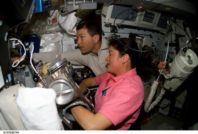
Astronaut Laurel B. Clark, STS-107 mission specialist, conducting a check of the YSTRES experiment in the Biopack incubator. Astronaut Rick D. Husband, mission commander, holds a vacuum cleaner to perform general housekeeping duties on the middeck of the Space Shuttle Columbia. (NASA)

The food is great and I am feeling very comfortable in this new, totally different environment. It still takes a while to eat as gravity doesn’t help pull food down your oesophagus. It is also a constant challenge to stay adequately hydrated. Since our body fluids are shifted toward our heads our sense of thirst is almost non-existent.

Thanks to many of you who have supported me and my adventures throughout the years. This was definitely one to beat all. I hope you could feel the positive energy that beamed to the whole planet as we glided over our shared planet.

Love to all, Laurel.”

You can find out more about Laurel Clark and the other STS-107 crew members on the NASA History site here.

Crew walkout for STS107 Credit; Scott Andrews/NASA

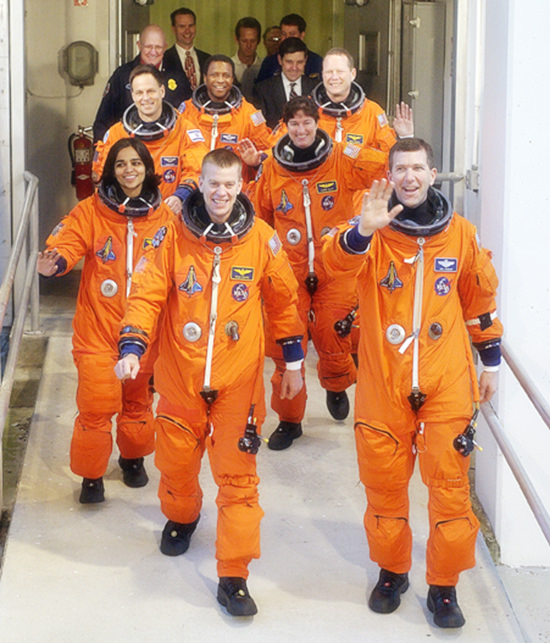
The STS-107 crew, waving to onlookers, exited the Operations and Checkout Building on their way to Launch Pad 39A for liftoff on Jan. 16, 2003. Leading the way were Pilot William “Willie” McCool (left) and Commander Rick Husband (right). Following in the second row are Mission Specialists Kalpana Chawla (left) and Laurel Clark; in the rear are Payload Specialist Ilan Ramon, Payload Commander Michael Anderson and Mission Specialist David Brown. All seven perished during re-entry breakup two weeks later on Feb. 1, 2003. (NASA)

See more of Laurel Nendza’s posts on her Facebook page, Stellar Eyes.

At 10 a.m. EST on Feb. 1, NASA TV will provide live coverage of a wreath-laying ceremony at the Space Mirror Memorial located in the Kennedy Space Center Visitor Complex in Florida. Flags across the agency will be flown at half-staff memory of the Columbia crew and all who have lost their lives in dedication of space exploration.

Historic First Use of Drill on Mars Set for Jan. 31 – Curiosity’s Sol 174

Image caption: Curiosity will conduct Historic 1st drilling into Martian rock at this spot where the robotic arm is pressing down onto the Red Planet’s surface at the John Klein outcrop of veined hydrated minerals. The Alpha Particle X-Ray Spectrometer (APXS) is in contact with the ground. This panoramic photo mosaic of Navcam camera images was snapped on Jan. 25 & 26, 2013 or Sols 168 & 169 and shows a self-portrait of Curiosity dramatically backdropped with her ultimate destination- Mount Sharp. Credit: NASA/JPL-Caltech/Ken Kremer/Marco Di Lorenzo

The long awaited and history making first use of a drill on Mars is set to happen on Thursday, Jan. 31, 2013, or Sol 174, by NASA’s Curiosity Mars Science Lab (MSL) rover, if all goes well, according to science team member Ken Herkenhoff of the USGS.

Curiosity’s first drilling operation entails hammering a test hole into a flat rock at the location where the rover is currently parked at a scientifically interesting outcrop of rocks with veined minerals called ‘John Klein’. See our mosaics above & below illustrating Curiosity’s current location.

“Drill tailings will not be collected during this test, which will use only the percussion (not rotation) drilling mode,” says Herkenhoff.

Curiosity is an incredibly complex robot that the team is still learning to operate. So the plan could change at a moment’s notice.

The actual delivery of drill tailings to Curiosity’s CheMin and SAM analytical labs is still at least several days or more away and must await a review of results from the test drill hole and further drilling tests.

“We are proceeding with caution in the approach to Curiosity’s first drilling,” said Daniel Limonadi, the lead systems engineer for Curiosity’s surface sampling and science system at NASA’s Jet Propulsion Laboratory (JPL). “This is challenging. It will be the first time any robot has drilled into a rock to collect a sample on Mars.”

On Sol 166, Curiosity drove about 3.5 meters to reach the John Klein outcrop that the team chose as the 1st drilling site. The car sized rover is investigating a shallow depression known as ‘Yellowknife Bay’ – where she has found widespread evidence for repeated episodes of the ancient flow of liquid water near her landing site inside Gale Crater on Mars.

In anticipation of Thursday’s planned drilling operation, the rover just carried out a series of four ‘pre-load’ tests on Monday (Jan. 27), whereby the rover placed the drill bit onto Martian surface targets at the John Klein outcrop and pressed down on the drill with the robotic arm. Engineers then checked the data to see whether the force applied matched predictions.

“The arm was left pressed against one of them overnight, to see how the pressure changed with temperature,’ says Herkenhoff.

Curiosity Sol 168_M34_2Aa_Ken Kremer

Image caption: Curiosity’s robotic arm places the robotic arm tool turret and Alpha Particle X-Ray Spectrometer (APXS) instrument on top of John Klein outcrop shown in this photo mosaic taken with the Mastcam 34 camera on Jan. 25, 2013, or Sol 168. The drill bit and prongs are pointing right on the tool turret. Credit: NASA/JPL-Caltech/MSSS/Ken Kremer/Marco Di Lorenzo

Because huge temperature swings occur on Mars every day (over 65 C or 115 F), the team needs to determine whether there is any chance of excessive stress on the arm while it is pressing the drill down onto the Martian surface. The daily temperature variations can cause rover systems like the arm, chassis and mobility system to expand and contact by about a tenth of an inch (about 2.4 millimeters), a little more than the thickness of a U.S. quarter-dollar coin.

“We don’t plan on leaving the drill in a rock overnight once we start drilling, but in case that happens, it is important to know what to expect in terms of stress on the hardware,” said Limonadi. “This test is done at lower pre-load values than we plan to use during drilling, to let us learn about the temperature effects without putting the hardware at risk.”

The high resolution MAHLI microscopic imager on the arm turret will take close-up before and after images of the outcrop target to assess the success of the drilling operation.

On Sol 175, another significant activity is planned whereby one of the ‘blank” organic check samples brought from Earth will be delivered to the SAM instrument for analysis as a way to check for any traces of terrestrial contamination of organic molecules and whether the sample handing system was successfully cleansed earlier in the mission at the Rocknest windblown sand ripple.

Meanwhile on the opposite side of Mars, NASA’s Opportunity rover starts Year 10 investigating never before touched phyllosilicate clay minerals that formed eons ago in flowing liquid water at Endeavour crater – detailed here.

Stay tuned for exciting results from NASA’s Martian sisters.

Ken Kremer

Curiosity at John Klein Sol170fa_Ken Kremer

Image caption: View to Mount Sharp from Curiosity at Yellowknife Bay and John Klein outcrop. This photo mosaic was taken with the Mastcam 34 camera on Jan. 27, 2013, or Sol 170. Credit: NASA/JPL/MSSS/ Marco Di Lorenzo/Ken Kremer

PIA16716_ip[1]

Curiosity’s Drill in Place for Load Testing Before Drilling. The percussion drill in the turret of tools at the end of the robotic arm of NASA’s Mars rover Curiosity has been positioned in contact with the rock surface in this image from the rover’s front Hazard-Avoidance Camera (Hazcam). Credit: NASA/JPL-Caltech

Curiosity & Yellowknife Bay Sol 157_4Ca_Ken Kremer

Image caption: Curiosity found widespread evidence for flowing water in the highly diverse, rocky scenery shown in this photo mosaic from the edge of Yellowknife Bay on Sol 157 (Jan 14, 2013) before driving to the John Klein outcrop at upper right. The rover then moved and is now parked at the flat rocks at the John Klein outcrop and is set to conduct historic 1st Martian rock drilling here on Jan. 31, 2013. ‘John Klein’ is filled with numerous mineral veins which strongly suggest precipitation of minerals from liquid water. Credit: NASA/JPL-Caltech/Ken Kremer/Marco Di Lorenzo

Opportunity Rover Starts Year 10 on Mars with Remarkable Science Discoveries

Image caption: Opportunity Celebrates 9 Years and 3200 Sols on Mars snapping this panoramic view from her current location on ‘Matijevic Hill’ at Endeavour Crater. The rover discovered phyllosilicate clay minerals and calcium sulfate veins at the bright outcrops of ‘Whitewater Lake’, at right, imaged by the Navcam camera on Sol 3197 (Jan. 20, 2013). “Copper Cliff” is the dark outcrop, at top center. Darker “Kirkwood” outcrop, at left, is site of mysterious “newberries” concretions. Credit: NASA/JPL-Caltech/Cornell/Marco Di Lorenzo/Ken Kremer

9 Years ago, NASA’s pair of identical twin sister rovers – christened Spirit & Opportunity- bounced to daunting airbag-cushioned landings on opposite sides of the Red Planet for what was supposed to be merely 90 day missions, or maybe a little bit longer scientists hoped.

Today, Opportunity celebrates a truly unfathomable achievement, starting Year 10 on Mars since she rolled to a bumpy stop on January 24, 2004 inside tiny Eagle crater. And she’s now at a super sweet spot for science (see our photo mosaic above) loaded with clays and veined minerals and making the most remarkable findings yet about the planets watery past – thus building upon a long string of previously unthinkable discoveries due to her totally unforeseen longevity.

“Regarding achieving nine years, I never thought we’d achieve nine months!” Principal Investigator Prof. Steve Squyres of Cornell University told Universe Today for this article commemorating Opportunity’s 9th anniversary.

Opportunity reached 3200 Sols, or Martian days, and counting , by her 9th birthday. She is now 108 months into the 3 month primary mission – that’s 36 times longer than the 3 month “warranty.”

“Every sol is a gift,” Squyres told me. He always refers to the rovers as our “Priceless assets on Mars”, that have to be taken good care of to wring out the maximum science data possible and for as long as humanly, or more aptly, robotically possible.

PIA16703_Sol3137B_Matijevic_Pan_L257atc_br2

Image Caption: ‘Matijevic Hill’ Panorama for Rover’s Ninth Anniversary. As Opportunity neared the ninth anniversary of its landing on Mars, the rover was working in the ‘Matijevic Hill’ area seen in this view from Opportunity’s panoramic camera (Pancam). Two of the features investigated at Matijevic Hill are “Copper Cliff,” the dark outcrop in the left center of the image, and “Whitewater Lake,” the bright outcrop on the far right. The component images for this mosaic were taken from Sol 3137 (Nov. 19, 2012) through Sol 3150 (Dec. 3, 2012). Credit: NASA/JPL-Caltech/Cornell/Arizona State Univ.

The resilient, solar powered Opportunity robot begins her 10th year roving around beautifully Earth-like Martian terrain where where she proved that potentially life sustaining liquid water once flowed billions of years ago when the planet was warmer and wetter.

Opportunity is healthy and has driven over 22 miles (35 kilometers )- marking the first overland expedition on another planet. See our photo mosaics and route map by Ken Kremer and Marco Di Lorenzo.

She is now working at the inboard edge of “Cape York” – a hilly segment of the eroded rim of 14 mile (22 km) wide Endeavour Crater, featuring terrain with older rocks than previously inspected and unlike anything studied before. It’s a place no one ever dared dream of reaching prior to launch in the summer of 2003 and landing on the Meridiani Planum region of Mars.

“It’s like a whole new mission since we arrived at Cape York,” says Squyres.

Opportunity Sol 3182_3Ba_Ken Kremer

Image caption: Opportunity Celebrates 9 Years on Mars snapping this panoramic view of the vast expanse of 14 mile (22 km) wide Endeavour Crater from atop ‘Matijevic Hill’ on Sol 3182 (Jan. 5, 2013). The rover then drove 43 feet to arrive at ‘Whitewater Lake’ and investigate clay minerals. Photo mosaic was stitched from Navcam images and colorized. Credit: NASA/JPL-Caltech/Cornell/Ken Kremer/Marco Di Lorenzo

Today Opportunity is poised for breakthrough science at deposits of phyllosilicates – clay minerals which stem from an earlier epoch when liquid water flowed on Mars eons ago and perhaps may have been more favorable to sustaining microbial life because they form in more neutral pH water. Endeavour Crater is more than 3 Billion years old.

I asked Squyres to discuss the discovery of the phyllosilicates – which have never before been analyzed up close on the Martian surface and are actually a main target of NASA’s new Curiosity rover at Gale Crater.

“We have found the phyllosilicates at Cape York: they’re in the Whitewater Lake materials,” Squyres explained. Spectral data collected from Mars orbit by the CRISM spectrometer aboard NASA’s MRO circling spacecraft allowed the researchers to direct Opportunity to this exact spot.

“Whitewater Lake” is an area of bright local outcrops currently being investigated and providing information about a different and apparently less acidic environment compared to other areas and craters visited earlier in the mission – and potentially more conducive to life.

Opportunity also discovered more mineral veins at “Whitewater Lake”, in addition to those hydrated mineral veins discovered earlier at Cape York at a spot named “Homestake” – see our mosaic below.

“We have investigated the veins in these materials, and we have determined that they are calcium sulfate,” Squyres confirmed to me.

Opportunity Sol 2761_2a_Ken Kremer

Image caption: Opportunity discovers hydrated Mineral Vein at Endeavour Crater – November 2011. Opportunity determined that the ‘Homestake’ mineral vein was composed of calcium sulfate,or gypsum, while exploring around the base of Cape York ridge at the western rim of Endeavour Crater. The vein discovery indicates the ancient flow of liquid water at this spot on Mars. This panoramic mosaic of images was taken on Sol 2761, November 2011, and illustrates the exact spot of the mineral vein discovery. Featured on NASA Astronomy Picture of the Day (APOD) on 12 Dec 2011. Credit: NASA/JPL/Cornell/Kenneth Kremer/Marco Di Lorenzo.

How do the new mineral veins compare to those at ‘Homestake’ and those just found by Curiosity at Yellowknife Bay inside Gale crater? I asked Sqyures.

“Much narrower, and possibly older,” he said compared to the Homestake calcium sulfate veins .

“It’s too early to say how they compare to the veins at Gale, though.”

The local area at “Cape York” is called “Matijevic Hill” – in honor of a recently deceased team member who played a key role on NASA’s Mars rovers.

The rover has already spent a few months at “Matijevic Hill” on a ‘walk about’ scouting survey and also found concretions dubbed “newberries” that are different from the “blueberry” concretions found earlier in the mission.

How widespread are the phyllosilicates ?

“Matijevic Hill is the only exposure of phyllosilicates we know of at Cape York, so in order to find more we’re going to have to go elsewhere,” Squyres replied. “We haven’t figured out what the “newberries” are yet, but attempting to do that will be our next task.”

It is likely to take many more weeks and even months to “figure out” what this all means for science.

Therefore, no one should expect the robot to move much in the near future. Since the rover made landfall at the western rim of Endeavour crater at Spirit Point in August 2011, she has been circling around Cape York ever since.

Opportunity Sol 2678c_Ken Kremer

Image caption: Opportunity rover first arrived at the western rim of Endeavour Crater (14 miles, 22 km wide) in August 2011. This photo mosaic of navcam images shows portions of the segmented rim of Endeavour crater on Sol 2678. Large ejecta blocks from a smaller nearby crater are visible in the middle. At Endeavour, Opportunity will investigate the oldest minerals deposits she has ever visited from billions of years ago and which may hold clues to environments that were potentially habitable for microbial life. The rover may eventually drive to Cape Tribulation at right if she survives. Credit: NASA/JPL/Cornell/Marco Di Lorenzo/Ken Kremer (kenkremer.com)

What is the next destination for Opportunity?

“Once we’re done at Cape York, our next destination will be Solander Point [to the south],” Squyres confirmed. It’s the next rim segment south of Cape York (see map).

Eventually, if Opportunity continues to function and survives the next Martian winter, she may be directed several miles even further south, along the crater rim to a spot called Cape Tribulation – because it also harbors caches of phyllosilicate clay minerals. But there is no telling when that might be.

“One step at a time,” said Squyres as always. He is not making any guesses or predictions. The mission is totally discovery driven.

Well after so many great science discoveries over the past 9 years, I asked Squyres to describe the context and significance of the phyllosilicates discovery?

“Impossible to say, I’m afraid… we’re still figuring this place out; I can’t put it in context yet,” Squyres concluded.

Thus, there is still so much more bountiful science research still to be done by Opportunity – and nobody is making any forecasts on how long she might yet survive.

So just keep praying to the Martian weather gods for occasional winds and “dust devils” to clean off those life giving solar panels – and to the US Congress to provide the essential funding.

Ken Kremer

Opportunity Sol 2852a_Ken Kremer

Image caption: Opportunity Phones Home – Dusty Self Portrait from Endeavour Crater on Mars on Sol 2852, February 2012. NASA’s rover Opportunity snaps self-portrait where she endured 5th frigid Martian winter at Greeley Haven. Opportunity is currently investigating Cape York ridge and Matijevic Hill at right. Vast expanse of Endeavour Crater and rim in background with dusty solar panels and full on view of the High Gain Antenna (HGA) in the foreground. Mosaic: NASA/JPL/Cornell/ASU/Marco Di Lorenzo/Ken Kremer

Opportunity Sol 2681a_annotated_Ken Kremer

Image caption: Endeavour Crater Panorama from Opportunity, Sol 2681, August 2011 on arrival at the rim of Endeavour and Cape York ridge. Odyssey crater visible at left. Mineral veins were later found to surround Cape York. Credit: NASA/JPL/Cornell/Marco Di Lorenzo/Ken Kremer

Opportunity Route map_3187s_Ken Kremer

Image caption: Traverse Map for NASA’s Opportunity rover from 2004 to 2013 – shows the entire path the rover has driven over 9 years, 3200 Sols and more than 22 miles (35 km) from Eagle Crater landing site to current location at Cape York ridge at Endeavour Crater. Credit: NASA/JPL/Cornell/ASU/Marco Di Lorenzo/Ken Kremer (kenkremer.com)

NASA: Reaches for New Heights – Greatest Hits Video

Video Caption: At NASA, we’ve been a little busy: landing on Mars, developing new human spacecraft, going to the space station, working with commercial partners, observing the Earth and the Sun, exploring our solar system and understanding our universe. And that’s not even everything.Credit: NASA

Check out this cool action packed video titled “NASA: Reaching for New Heights” – to see NASA’s ‘Greatest Hits’ from the past year

The 4 minute film is a compilation of NASA’s gamut of Robotic Science and Human Spaceflight achievements to explore and understand Planet Earth here at home and the heavens above- ranging from our Solar System and beyond to the Galaxy and the vast expanse of the Universe.

Image caption: Planets and Moons in perspective. Credit: NASA

The missions and programs featured include inspiringly beautiful imagery from : Curiosity, Landsat, Aquarius, GRACE, NuSTAR, GRAIL, Dawn at Asteroid Vesta, SDO, X-48C Amelia, Orion, SLS, Apollo, SpaceX, Sierra Nevada Dream Chaser, Boeing CST-100, Commercial Crew, Hurricane Sandy from the ISS, Robonaut and more !

And even more space exploration thrills are coming in 2013 !

Ken Kremer

IMG_3760a_SpaceX launch 22 May 2012

Image caption: SpaceX Falcon 9 rocket blasts off on May 22, 2012 with Dragon cargo capsule from Space Launch Complex-40 at Cape Canaveral Air Force Station, Fla., on the first commercial mission to the International Space Station. The next launch is set for March 1, 2013. Credit: Ken Kremer

Curiosity’s Robotic Arm Camera Snaps 1st Night Images

Image caption: This image of a Martian rock illuminated by white-light LEDs (light emitting diodes) is part of the first set of nighttime images taken by the Mars Hand Lens Imager (MAHLI) camera at the end of the robotic arm of NASA’s Mars rover Curiosity. The image was taken on Jan. 22, 2013, after dark on Sol 165. It covers an area about 1.3 inches by 1 inch (3.4 by 2.5 centimeters). Credit: NASA/JPL-Caltech/MSSS

Curiosity’s high resolution robotic arm camera has just snapped the 1st set of night time images of a Martian rock of the now 5 1/2 month long mission – using illumination from ultraviolet and white light emitting LED’s. See the images above and below.

The Mars Hand Lens Imager (MAHLI) camera is located on the tool turret at the end of Curiosity’s 7 foot (2.1 m) long robotic arm.

MAHLI took the close-up images of a rock target named “Sayunei” on Jan. 22 (Sol 165), located near the front-left wheel after the rover had driven over and scuffed the area to break up rocks in an effort to try and expose fresh material, free of obscuring dust.

“Sayunei” is at the site of the “John Klein” outcrop in “Yellowknife Bay” where the team hopes to commence the 1st rock drilling operations here in the coming days. Curiosity drove a few meters several sols ago to reach “John Klein”.

See below our Sol 157 mosaic showing the “John Klein” outcrop – where the rover snapped these night images of “Sayunei”.

721606main_pia16712-43_1024-768

Image caption: This image of a Martian rock illuminated by ultraviolet LEDs (light emitting diodes) is part of the first set of nighttime images taken by the MAHLI camera on the robotic arm. The image was taken on Jan. 22, 2013, after dark on Sol 165. It covers an area about 1.3 inches by 1 inch (3.4 by 2.5 centimeters). Credit: NASA/JPL-Caltech/MSSS

“The purpose of acquiring observations under ultraviolet illumination was to look for fluorescent minerals,” said MAHLI Principal Investigator Ken Edgett of Malin Space Science Systems, San Diego. “These data just arrived this morning. The science team is still assessing the observations. If something looked green, yellow, orange or red under the ultraviolet illumination, that’d be a more clear-cut indicator of fluorescence.”

Analysis is still in progress to determine whether fluorescent minerals are present. Certain classes of organic compounds are also fluorescent.

MAHLI is an adjustable focus camera that works over a wide range. It can focus on targets just a few centimeters away or on distant objects like Mount Sharp, over 6 miles (10 km) away.

The LED’s surround the MAHLI lens.

Curiosity has discovered widespread evidence for the ancient flow of liquid water at “Yellowknife Bay” in the form of water bearing mineral veins, cross-bedded layering, nodules and spherical sedimentary concretions.

Ken Kremer

Curiosity & Yellowknife Bay Sol 157_4Ca_Ken Kremer

Image caption: Curiosity found widespread evidence for flowing water in the highly diverse, rocky scenery shown in this photo mosaic from the edge of Yellowknife Bay on Sol 157 (Jan 14, 2013). The rover will soon conduct 1st Martian rock drilling operation at flat, light toned rocks at the outcrop called “John Klein”, at center, the site where she is now located. ‘John Klein’ drill site and ‘Sheep Bed’ outcrop ledges to right of rover arm are filled with numerous mineral veins and spherical concretions which strongly suggest precipitation of minerals from liquid water. ‘Snake River’ rock formation is the linear chain of rocks protruding up from the Martian sand near rover wheel. Credit: NASA/JPL-Caltech/Ken Kremer/Marco Di Lorenzo

27 Years Ago: Voyager 2’s Visit to Uranus

Image of Uranus’ crescent taken by a departing Voyager 2 on January 25, 1986 (NASA/JPL)

27 years ago today, January 24, 1986, NASA’s Voyager 2 spacecraft sped past Uranus, becoming simultaneously the first and last spacecraft to visit the blue-tinged gas giant, third largest planet in the Solar System.

The image above shows the crescent-lit Uranus as seen by Voyager 2 from a distance of about 965,000 km (600,000 miles.) At the time the spacecraft had already passed Uranus and was looking back at the planet on its way outwards toward Neptune.

Although composed primarily of hydrogen and helium, trace amounts of methane in Uranus’ uppermost atmosphere absorb most of the red wavelengths of light, making the planet appear a pale blue color.

12bg-1

Image of the 1,500-km-wide Oberon acquired by Voyager 2 on Jan. 24, 1986 (NASA/JPL)

The second of NASA’s twin space explorers (although it launched first) Voyager 2 came within 81,800 kilometers (50,600 miles) of Uranus on January 24, 1986, gathering images of the sideways planet, its rings and several of its moons. Voyager 2 also discovered the presence of a magnetic field around Uranus, as well as 10 new small moons.

6bg

Three moons discovered by Voyager 2 in 1986 (NASA/JPL)

Data gathered by Voyager 2 revealed that Uranus’ rate of rotation is 17 hours, 14 minutes.

At the time of this writing, Voyager 2 is 15,184,370,900 km from Earth and steadily moving toward the edge of the Solar System at a speed of about 3.3 AU per year. At that distance, signals from Voyager take just over 14 hours and 4 minutes to reach us.

See images from Voyager 2’s visit of Uranus here, and check out a video of the August 20, 1977 launch below along with more images from the historic Voyager mission’s “Grand Tour” of the outer Solar System.

NASA Stars at 2013 Presidential Inaugural Parade with Orion and Curiosity – Photos and Video

Image caption: Orion deep space crew capsule float passes in front of the White House at the Presidential Inaugural parade on Jan 21, 2013 in Washington, DC. Credit: NASA

NASA’s new Orion deep space crew capsule and sensational Curiosity Mars rover had starring roles at the 2013 Presidential Inaugural Parade held on Monday, Jan 21, 2013 in Washington D.C.

NASA photographers captured stunning photos and video (above and below) as Orion and Curiosity passed in front of the White House and the official reviewing stand – with President Obama & VP Joe Biden and their families and numerous dignitaries smiling and waving.

Beautiful weather shined though out the entire day’s festivities and into the early evening as full size models of Orion and Curiosity made their way thought the capitol streets to participate in the 2013 Inaugural parade.

NASA’s floats prominently placed near the front of the parade and seen on Live TV about 530 PM EDT as well as by about a million spectators on hand.

8403941024_d82bee7a00_b[1]

Image caption: Curiosity Mars rover float passes in front of the White House and reviewing stand at the Presidential Inaugural parade on Jan 21, 2013 in Washington, DC. Credit: NASA

The fantastically successful Curiosity rover is discovering widespread evidence for the ancient flow of liquid water on Mars.

The Orion multi-purpose capsule will take our astronauts back to the Moon and farther into deep space than ever before.

NASA is the ONLY federal agency asked to be in the inaugural parade. Curiosity led the way followed by Orion.


Video of full-size models of the Curiosity Mars rover and Orion, the multi-purpose capsule that will take our astronauts farther into space than ever, as they appeared in the Washington, D.C. parade on Jan. 21.

Accompanying the NASA vehicles were members of the Curiosity team from NASA’s Jet Propulsion Laboratory, and current and former astronauts Alvin Drew, Serena Aunon, Kate Rubins, Mike Massimino, Lee Morin and Kjell Lindgren, as well as Leland Melvin, NASA’s associate administrator for Education, and John Grunsfeld, NASA’s associate administrator for Science.

Be sure to check out NASA’s Flickr stream for many photos from the 2013 Inaugural Day festivities and parade – here and here

See my preview story – here

Ken Kremer

NASA’s Curiosity and Orion Shine at Presidential Inaugural Parade

Video caption: Preview of Mars Curiosity Parade Float. Jim Green, Director of the Science Mission Directorate Planetary Systems Division at NASA Headquarters, describes the replica of the Mars Curiosity Rover on the second NASA float in Monday’s (Jan 21, 2013) presidential inaugural parade. Parade photos below

Full scale models of NASA’s Curiosity Mars rover and the Orion crew capsule are participating in the 2013 Presidential Inaugural Parade on Monday, Jan 21, 2013, in Washington, DC – representing NASA’s robotic and human spaceflight endeavors.

The fantastically successful Curiosity rover is discovering widespread evidence for the ancient flow of liquid water on Mars.

The Orion multi-purpose capsule will take our astronauts back to the Moon and farther into space than ever.

NASA is the ONLY federal agency asked to be in the inaugural parade and now Curiosity is leading the NASA group with Orion after Curiosity.

Update 530 PM EDT – NASA’s 2 floats just passed by a cheering and waving President Obama & VP Biden at the reviewing stand in front of the White House – prominently near the front of the parade. See float photos from the parade below

Walking alongside both floats are members of the Curiosity team from NASA’s Jet Propulsion Laboratory – including ‘Mohawk Guy’ – and several current and former astronauts.

The participating astronauts are Alvin Drew, Serena Aunon, Kate Rubins, Mike Massimino, Lee Morin and Kjell Lindgren, as well as Leland Melvin, NASA’s associate administrator for Education, and John Grunsfeld, NASA’s associate administrator for Science.

The marching team for Curiosity includes Richard Cook-project manager (from JPL), Bobak Ferdowsi (otherwise known as ‘Mohawk Guy’)-flight director (from JPL), Dave Lavery – program executive (from NASA Headquarters) , Michael Meyer – program Scientist (from NASA Headquarters), Jennifer Trosper-mission manager (from JPL) and Ashwin Vasavada, Deputy Project Scientist (from JPL)

Image caption: Orion crew capsule float with NASA astronauts at the Presidential Inaugural parade on Jan 21, 2013 in Washington, DC. Credit: NASA

8402760689_9bf9ce1a26_c

Image caption: Curiosity float with team members at the Presidential Inaugural parade on Jan 21, 2013 in Washington, DC. Credit: NASA

Be sure to check out NASA’s Flickr stream for many photos from the 2013 Inaugural Day festivities and parade – here and here

Here’s another video about the Curiosity float:

Ken Kremer

8398255959_1f3cc1f421_c

Image caption: Orion crew capsule arrives in Washington, DC, for Presidential Inaugural parade on Jan 21, 2013. Credit: NASA

Watery Science ‘Jackpot’ Discovered by Curiosity

Curiosity found widespread evidence for flowing water in the highly diverse, rocky scenery shown in this photo mosaic from the edge of Yellowknife Bay on Sol 157 (Jan 14, 2013). The rover will soon conduct 1st Martian rock drilling operation at flat, light toned rocks at the outcrop called “John Klein”, at center. ‘John Klein’ drill site and ‘Sheep Bed’ outcrop ledges to right of rover arm are filled with numerous mineral veins and spherical concretions which strongly suggest precipitation of minerals from liquid water. ‘Snake River’ rock formation is the linear chain of rocks protruding up from the Martian sand near rover wheel. Credit: NASA/JPL-Caltech/Ken Kremer/Marco Di Lorenzo

The Curiosity rover hit the science “jackpot” and has discovered widespread further evidence of multiple episodes of liquid water flowing over ancient Mars billions of years ago when the planet was warmer and wetter, scientists announced. The watery evidence comes in the form of water bearing mineral veins, cross-bedded layering, nodules and spherical sedimentary concretions.

Any day now NASA’s mega robot will be instructed to drill directly into veined rocks where water once flowed, the team announced at a media briefing this week.

Delighted researchers said Curiosity surprisingly found lots of evidence for light-toned chains of linear mineral veins inside fractured rocks littering the highly diverse Martian terrain – using her array of ten state-of-the-art science instruments. Veins form when liquid water circulates through fractures and deposit minerals, gradually filling the insides of the fractured rocks over time.

Sometime in the next two weeks or so, NASA’s car sized rover will carry out history’s first ever drilling inside a Martian rock that was “percolated” by liquid water – an essential prerequisite for life as we know. A powdered sample will then be delivered to the robots duo of analytical chemistry labs (CheMin & SAM) to determine its elemental composition and ascertain whether organic molecules are present.

The drill target area is named “John Klein” outcrop, in tribute to a team member who was the deputy project manager for Curiosity at JPL for several years and who passed away in 2011.

“We identified a potential drill target and are preparing to do drill activities in the next two weeks. We are ready to go,” said Richard Cook, the project manager of NASA’s Jet Propulsion Laboratory (JPL) in Pasadena, Calif.

“Drilling [into a rock] is the most significant engineering activity since landing. It is the most difficult aspect of the surface mission, interacting with an unknown surface terrain, and has never been done on Mars. We will go slowly. It will take some time to deliver samples to CheMin and SAM and will be a great set of scientific measurements.”

pia16705annotated-br2

Image caption: Mineral veins of calcium sulfate discovered by Curiosity at ‘Sheepbed’ Outcrop. These veins form when water circulates through fractures, depositing minerals along the sides of the fracture, to form a vein. These vein fills are characteristic of the stratigraphically lowest unit in the “Yellowknife Bay” area where Curiosity is currently exploring and were imaged on Sol 126 (Dec. 13, 2012) by the telephoto Mastcam camera. Image has been white-balanced. Credit: NASA/JPL-Caltech/MSSS

“The scientists have been let into the candy store,” said Cook referring to the unexpected wealth of science targets surrounding the rover at this moment.

“There is a high diversity of rocks types here to characterize,” added Mike Malin, Mastcam principal investigator of Malin Space Science Systems (MSSS). “We see layering, veins and concretions. The area is still undergoing some changes.”

Curiosity is just a few meters away from ‘John Klein’ and will drive to the site shortly from her location inside ‘Yellowknife Bay’ beside the ‘Snake River’ rock formation. To see where Curiosity is in context with ‘John Klein’ and “Snake River’, see our annotated context mosaic (by Ken Kremer & Marco Di Lorenzo) as the rover collects data at a rock ledge.

The white colored veins were discovered over the past few weeks- using the high resolution mast- mounted imaging cameras and ChemCam laser firing spectrometer -at exactly the vicinity where Curiosity is currently investigating ; around a shallow basin called Yellowknife Bay and roughly a half mile away from the landing site inside Gale Crater.

“This lowest unit that we are at in Yellowknife Bay, the very farthest thing we drove to, turns out to be kind of the ‘jackpot’ unit here,” said John Grotzinger, the mission’s chief scientist of the California Institute of Technology. “It is literally shot through with these fractures and vein fills.”

pia16567-43[1]

Image caption: ‘John Klein’ Site Selected for Curiosity’s Drill Debut. This view shows the patch of veined, flat-lying rock selected as the first drilling site. The rover’s right Mast Camera equipped with a telephoto lens, was about 16 feet (5 meters) away from the site when it recorded this mosaic on sol 153 (Jan. 10, 2013). The area is shot full of fractures and veins, with the intervening rock also containing concretions, which are small spherical concentrations of minerals. Enlargement A shows a high concentration of ridge-like veins protruding above the surface. Some of the veins have two walls and an eroded interior. Enlargement B shows that in some portions of this feature, there is a horizontal discontinuity a few centimeters or inches beneath the surface. The discontinuity may be a bed, a fracture, or potentially a horizontal vein. Enlargement C shows a hole developed in the sand that overlies a fracture, implying infiltration of sand down into the fracture system. Image has been white-balanced. Credit: NASA/JPL-Caltech/MSSS

Shortly after landing the team took a calculated gamble and decided to take a several months long detour away from the main destination of the towering, sedimentary mountain named Mount Sharp, and instead drive to an area dubbed ‘Glenelg’ and home to ‘Yellowknife Bay’, because it sits at the junction of a trio of different geologic terrains. Glenelg exhibits high thermal inertia and helps put the entire region in better scientific context. The gamble has clearly payed off.

“We chose to go there because we saw something anomalous, but wouldn’t have predicted any of this from orbit,” said Grotzinger.

The Chemistry and Camera (ChemCam) instrument found elevated levels of calcium, sulfur and hydrogen. Hydrogen is indicative of water.

The mineral veins are probably comprised of calcium sulfate – which exists in several hydrated (water bearing) forms.

“The ChemCam spectra point to a composition very high in calcium. These veins are likely composed of hydrated calcium sulfate, such as bassinite or gypsum, depending on the hydration state,” said ChemCam team member Nicolas Mangold of the Laboratoire de Planétologie et Géodynamique de Nantes in France. “On Earth, forming veins like these requires water circulating in fractures and occur at low to moderate temperatures.”

The newly found veins appear quite similar to analogous veins discovered in late 2011 by NASA’s Opportunity rover – Curiosity’s older sister – inside Endeavour crater and nearly on the opposite side of Mars. See our Opportunity vein mosaic featured at APOD on Dec. 11, 2011 to learn more about veined rocks.

“What these vein fills tell us is water moved and percolated through these rocks, through these fracture networks and then minerals precipitated to form the white material which ChemCam has concluded is very likely a calcium sulfate, probably hydrated in origin,” Grotzinger explained.

“So this is the first time in this mission that we have seen something that is not just an aqueous environment, but one that also results in precipitation of minerals, which is very attractive to us.”

Yellowknife Bay and the ‘John Klein’ drilling area outcrop are chock full of mineral veins and sedimentary concretions.

“When you put all this together it says that basically these rocks were saturated with water. There may be several phases to this history of water, but that’s still to be worked out.”

“This has been really exciting and we can’t wait to start drilling,” Grotzinger emphasized.

Curiosity can drill about 2 inches (5 cm) into rocks. Ultimately a powdered sample about half an aspirin tablet in size will be delivered to SAM and CheMin after a few weeks. All rover systems and instruments are healthy, said Cook.

Grotzinger said that Curiosity will be instructed to drive over the veins to try and break them up and expose fresh surfaces for analysis. Then she will drill directly into a vein and hopefully catch some of the surrounding material as well.

“This will reveal the mineralogy of the vein filling material and how many hydrated mineral phases are present. The main goal is this will give us an assessment of the habitability of this environment.”

As the rover has driven down the shallow depression to deeper stratigraphic layers, the units are older in time.

After the first drill sample is fully analyzed, Grotzinger told me that the team will reevaluate whether to drill into a second rock.

The team doesn’t yet know whether the flowing water from which the veins precipitated was a more neutral pH or more acidic. “It’s too early to tell. We need to drill into the rock to tell and determine the mineralogy,” Grotzinger told me. Neutral water is more hospitable to life.

How long the episodes of water flowed is not yet known and it’s a complex history. But the water was at least hip to ankle deep at times and able to transport and round the gravel.

“There are a broad variety of sedimentary rocks here, transported from elsewhere. Mars was geologically active in this location, which is totally cool !,” said Aileen Yingst, MAHLI deputy principal investigator. ”There are a number of different transport mechanisms in play.”

719254main_pia16708-43_946-710

Image caption: Curiosity’s Traverse into Different Terrain. This image maps the traverse of NASA’s Mars rover Curiosity from “Bradbury Landing” to “Yellowknife Bay,” with an inset documenting a change in the ground’s thermal properties with arrival at a different type of terrain. credit: NASA/JPL-Caltech/Univ. of Arizona/CAB(CSIC-INTA)/FMI

Drilling goes to the heart of the mission and will mark a historic feat in planetary exploration – as the first time that an indigenous sample has been cored from the interior of a rock on another planet and subsequently analyzed by chemical spectrometers to determine its elemental composition and determine if organic molecules are present .

The high powered hammering drill is located on the tool turret at the end of the car-sized robots 7 foot (2.1 meter) long mechanical arm . It is the last of Curiosity’s ten instruments that remains to be checked out and put into action.

Curiosity landed on the Red Planet five months ago inside Gale Crater to investigate whether Mars ever offered an environment favorable for microbial life, past or present and is now nearly a quarter of the way through her two year prime mission.

Curiosity might reach the base of Mount Sharp by the end of 2013, which is about 6 miles (10 km) away as the Martian crow flies.

Ken Kremer

718888main_pia16615-43_946-710

Image Caption: Calcium-Rich Veins in Martian Rocks. This graphic shows close-ups of light-toned veins in rocks in the “Yellowknife Bay” area of Mars together with analyses of their composition. The top part of the image shows a close-up of the rock named “Crest,” taken by the remote micro-imager (RMI) on Curiosity’s Chemistry and Camera (ChemCam) instrument above the analysis of the elements detected by using ChemCam’s laser to zap the target. The spectral profile of Crest’s light-colored vein is shown in red, while that of a basaltic calibration target of known composition is shown in black. The bottom part of the image shows ChemCam’s close-up of the rock named “Rapitan” with the analysis of its elemental composition. The spectral profile of Rapitan’s light-colored vein is shown in blue, while that of a basaltic calibration target of known composition is shown in black. These results suggest the veins are unlike typical basaltic material. They are depleted in silica and composed of a calcium-bearing mineral. Credit: NASA/JPL-Caltech/LANL/CNES/IRAP/LPGNantes/CNRS

Curiosity at Snake River Sol 149_5Aa_drill target_Ken Kremer

Image caption: Curiosity will carry out 1st rock drilling at ‘John Klein’ outcrop visible in this time lapse mosaic showing movements of Curiosity rover’s arm on Sol 149 (Jan. 5, 2013) at Yellowknife Bay basin where the rover has found widespread evidence for flowing water. Curiosity discovered hydrated mineral veins and concretions around the rock ledge ahead . She next drove there for contact science near the slithery chain of narrow protruding rocks known as ‘Snake River. Photomosaic stitched from Navcam raw images and colorized. Credit: NASA/JPL-Caltech/Ken Kremer/Marco Di Lorenzo