Wide-field Infrared Survey Explorer (WISE) spacecraft. Credit: NASA.
A hibernating spacecraft has been called back into service. The WISE (Wide-field Infrared Survey Explorer”) spacecraft that has been sleeping in a polar orbit around Earth for two years will be turned back on next month to hunt for more potentially hazardous asteroids, and perhaps search for an asteroid that NASA could capture and explore in the future.
“The WISE mission achieved its mission’s goals and as NEOWISE extended the science even further in its survey of asteroids. NASA is now extending that record of success, which will enhance our ability to find potentially hazardous asteroids, and support the new asteroid initiative,” said John Grunsfeld, NASA’s associate administrator for science. “Reactivating WISE is an excellent example of how we are leveraging existing capabilities across the agency to achieve our goal.”
WISE originally was launched in December 2009 and scanned the entire celestial sky in infrared light about 1.5 times, searching for the coolest stars, the universe’s most luminous galaxies and some of the darkest near-Earth asteroids and comets. It captured more than 2.7 million images of objects in space, ranging from faraway galaxies to asteroids and comets close to Earth.
However, in early October 2010, after completing its prime science mission, the spacecraft ran out of the frozen coolant that keeps its instrumentation cold. But two of its four infrared cameras remained operational, which were still optimal for asteroid hunting, so NASA extended the NEOWISE portion of the WISE mission by four months, with the primary purpose of hunting for more asteroids and comets, and to finish one complete scan of the main asteroid belt.
The NEOWISE mission completed a full sweep of the main asteroid belt, and during 2010, NEOWISE observed about 158,000 rocky bodies out of approximately 600,000 known objects. Discoveries included 21 comets, more than 34,000 asteroids in the main belt between Mars and Jupiter, and 135 near-Earth objects.
“The data collected by NEOWISE two years ago have proven to be a gold mine for the discovery and characterization of the NEO population,” said Lindley Johnson, NASA’s NEOWISE program executive in Washington. “It is important that we accumulate as much of this type of data as possible while the WISE spacecraft remains a viable asset.”
Now WISE will again search for asteroids with a new extra-extended three year mission to search for more PHAs as well as suitable asteroids for future human exploration missions.
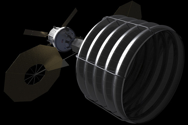
Concept of NASA spacecraft with Asteroid capture mechanism deployed to redirect a small space rock to a stable lunar orbit for later study by astronauts aboard Orion crew capsule. Credit: NASA.
NASA said they anticipate WISE will use its 16-inch (40-centimeter) telescope and infrared cameras to discover about 150 previously unknown NEOs and characterize the size, albedo and thermal properties of about 2,000 others — including some of which could be candidates for the agency’s recently announced asteroid initiative.
“The team is ready and after a quick checkout, we’re going to hit the ground running,” said Amy Mainzer, NEOWISE principal investigator at NASA’s Jet Propulsion Laboratory in Pasadena, Calif. “NEOWISE not only gives us a better understanding of the asteroids and comets we study directly, but it will help us refine our concepts and mission operation plans for future, space-based near-Earth object cataloging missions.”
Polar mesospheric clouds shine over a midnight sunrise above Alaska on August 4, 2013 (NASA)
Looking for a new desktop background? This might do nicely: a photo of noctilucent “night-shining” clouds seen above a midnight Sun over Alaska, taken from the ISS as it passed over the Aleutian Islands just after midnight local time on Sunday, August 4.
When this photo was taken Space Station was at the “top of the orbit” — 51.6 ºN, the northernmost latitude that it reaches during its travels around the planet.
According to the NASA Earth Observatory site, “some astronauts say these wispy, iridescent clouds are the most beautiful phenomena they see from orbit.” So just what are they? Read on…
Found about 83 km (51 miles) up, noctilucent clouds (also called polar mesospheric clouds, or PMCs) are the highest cloud formations in Earth’s atmosphere. They form when there is just enough water vapor present to freeze into ice crystals. The icy clouds are illuminated by the Sun when it’s just below the horizon, after darkness has fallen or just before sunrise, giving them their eponymous property.
NLCs seen in the southern hemisphere in Jan. 2010 (NASA)
Noctilucent clouds have also been associated with rocket launches, space shuttle re-entries, and meteoroids, due to the added injection of water vapor and upper-atmospheric disturbances associated with each. Also, for some reason this year the clouds appeared a week early.
Some data suggest that these clouds are becoming brighter and appearing at lower latitudes, perhaps as an effect of global warming putting more greenhouse gases like methane into the atmosphere.
“When methane makes its way into the upper atmosphere, it is oxidized by a complex series of reactions to form water vapor,” said James Russell, the principal investigator of NASA’s Aeronomy of Ice in the Mesosphere (AIM) project and a professor at Hampton University. “This extra water vapor is then available to grow ice crystals for NLCs.”
A comparison of noctilucent cloud formation from 2012 and 2013 has been compiled using data from the AIM spacecraft. You can see the sequence here.
And for an incredible motion sequence of noctilucent clouds — taken from down on the ground — check out the time-lapse video below by Maciej Winiarczyk, coincidentally made at around the same time as the ISS photo above:
(The video was featured as the Astronomy Picture of the Day (APOD) for August 19, 2013.)
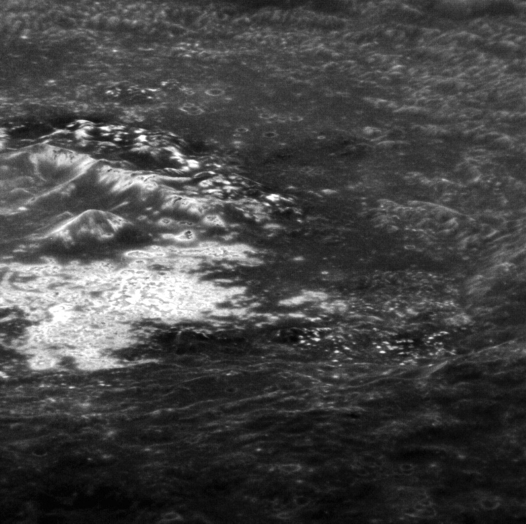
Hi-res targeted MESSENGER image of the interior of Tyagaraja crater (north is to the right).
Here’s a rather interesting view from orbit around the innermost planet: Mercury’s Tyagaraja crater, the interior of which is seen here in an oblique-angled image acquired by the MESSENGER spacecraft on November 12, 2011 (and released August 16, 2013.)
This view looks west across the northern portion of the 97-kilometer (60-mile) -wide crater, and shows some of its large central peaks, terraced walls, and bright erosion features called hollows that are spread across a wide swath of its interior.
First seen by MESSENGER in 2011, hollows are thought to indicate an erosion process unique to Mercury because of its composition and close proximity to the Sun. The lack of craters within hollows seems to indicate that they are relatively young features… in fact, they may be part of a process that continues today.
This image was acquired as a high-resolution targeted observation. Targeted observations are images of a small area on Mercury’s surface at resolutions much higher than the 200-meter/pixel morphology base map.
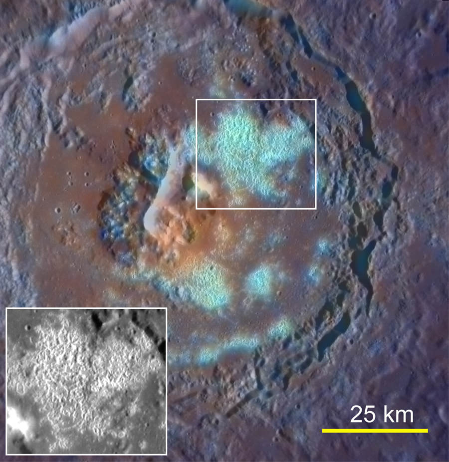
Enhanced-color image of Tyagaraja crater acquired on Sept. 29, 2011. Its large hollow field is highlighted.
Tyagaraja is named after Kakarla Tyagabrahmam, an 18th-century composer of classical Indian Carnatic music.
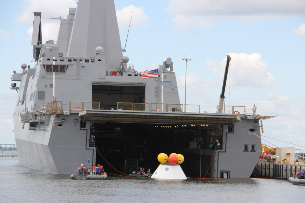
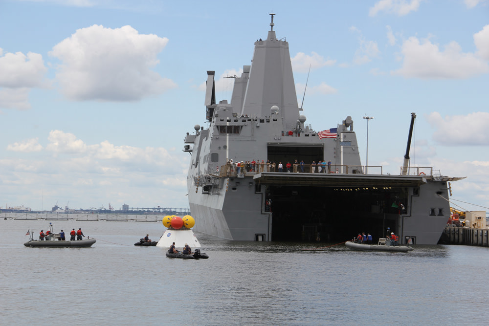
During the stationary recovery test of Orion at Norfolk Naval Base on Aug. 15, US Navy divers attached tow lines and led the test capsule to a flooded well deck on the USS Arlington. Credit: Ken Kremer/kenkremer.com
During the stationary recovery test of Orion at Norfolk Naval Base on Aug. 15, 2013, US Navy divers attached tow lines and led the test capsule to a flooded well deck on the USS Arlington. Credit: Ken Kremer/kenkremer.com. Story updated with additional test Video and images[/caption]
NAVAL STATION NORFOLK,VA – When American astronauts again venture into deep space sometime in the next decade, their return trip to Mother Earth will end with the splashdown of their Orion capsule in the Pacific Ocean – much like the Apollo lunar landing crews of four decades ago.
But before that can happen, Orion must first pass through a myriad of milestones to insure the safe return of our human crews.
A NASA and U.S. Navy test successfully demonstrated the water recovery of the Orion crew module today (Aug. 15) at Naval Station Norfolk in Virginia – and Universe Today witnessed the entire operation.
“Today’s test was terrific,” Scott Wilson, NASA’s Orion Manager of Production Operations, told Universe Today in a post test interview at Naval Station Norfolk.
“We got all the data we needed and the test was very successful. This was exactly what we wanted to do and we don’t like surprises.”
US Navy divers on four boats attached tow lines and to the Orion test capsule and guide it to the well deck on the USS Arlington during Aug. 15 recovery test at Norfolk Naval Base, VA.
Credit: Ken Kremer/kenkremer.com
Today’s ‘Orion Stationary Recovery Test’ was conducted to support the upcoming first flight of Orion on the EFT-1 mission due to blastoff in September 2014 from Cape Canaveral, Florida.
“We completed all of our primary and secondary test objectives,” Wilson stated.
Teams of US Navy divers in a flotilla of amphibious boats launched from the USS Arlington approached a test version of the Orion capsule known as the boilerplate test article (BTA). The Arlington was docked against its pier during the test in a benign, controlled environment.
Dive teams attach tow lines to Orion test capsule during Aug. 15 recovery test at Norfolk Naval Base, VA. Credit: Ken Kremer/kenkremer.com
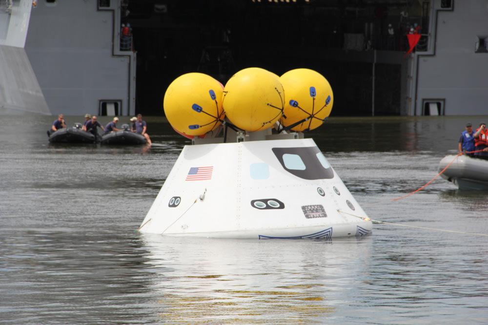
Divers attached several tow lines to the capsule, in a coordinated operation with the Arlington, and led the capsule into the ship’s flooded well deck.
The Orion capsule was carefully towed inside the well deck and positioned over the recovery cradle. The sea water was drained and the capsule was attached to the recovery cradle.
Dive teams haul Orion onto the well deck of the USS Arlington during Aug. 15 recovery test at Norfolk Naval Base, VA. Credit: Ken Kremer/kenkremer.com
“During the test there is constant radio communications between the ship and the divers teams in the boats.”
“The operation within the well deck areas are also being controlled as well as the rope and winch handlers on the boat,” Wilson told me.
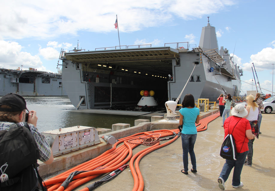
At the conclusion of the test, myself and the NASA social media participants boarded the USS Arlington and toured the Orion capsule for a thrilling up close look.
Myself and NASA social media participants observed Orion after hauled aboard the well deck and boarded the USS Arlington recovery ship. Credit: Ken Kremer/kenkremer.com
“Today marks a significant milestone in the Navy’s partnership with NASA and the Orion Human Space Flight Program,” said Navy Commander Brett Moyes, Future Plans Branch chief, U.S. Fleet in a statement.
“The Navy is excited to support NASA’s continuing mission of space exploration. Our unique capabilities make us an ideal partner for NASA in the recovery of astronauts in the 21st century — just as we did nearly a half century ago in support of America’s quest to put a man on the moon.”
The ocean recovery of Orion will be far different from the Apollo era where the crew’s were first hoisted out of the floating capsule and the capsule then hoisted on deck of a US Navy aircraft carrier.
The next Orion water recovery test will be conducted in the open waters of the Pacific Ocean in January 2014.
Inside up close look at the Orion attached to the recovery cradle in the drained well deck of the USS Arlington recovery ship. Credit: Ken Kremer/kenkremer.com
NASA’s Langley Research Center in nearby Hampton, VA is conducting an extensive drop test program in support of the Orion project.
“The Orion capsule tested today has the same mold line and dimensions as the Orion EFT-1 capsule.”
“The Orion hardware and the Delta IV Heavy booster for the EFT-1 launch are on target for launch in 2014,” Wilson told me.
Watch this NASA Video of the Orion test:
During the unmanned Orion EFT-1 mission, the capsule will fly on a two orbit test flight to an altitude of 3,600 miles above Earth’s surface, farther than any human spacecraft has gone in 40 years.
The EFT-1 mission will provide engineers with critical data about Orion’s heat shield, flight systems and capabilities to validate designs of the spacecraft before it begins carrying humans to new destinations in the solar system, including an asteroid and Mars.
It will return to Earth at a speed of approximately 20,000 mph for a splashdown in the Pacific Ocean.
Right now its T Minus 1 Year and counting to liftoff of Orion EFT-1.
…………….
Learn more about Orion, Cygnus, Antares, LADEE, MAVEN, Mars rovers and more at Ken’s upcoming presentations
Sep 5/6/16/17: LADEE Lunar & Antares/Cygnus ISS Rocket Launches from Virginia”; Rodeway Inn, Chincoteague, VA, 8 PM
Oct 3: “Curiosity, MAVEN and the Search for Life on Mars – (3-D)”, STAR Astronomy Club, Brookdale Community College & Monmouth Museum, Lincroft, NJ, 8 PM
Social media and media including Ken observe the Aug. 15 Orion water recovery test from the pier at Naval Station Norfolk, VA. Credit: NASAScott Wilson, NASA’s Orion production manager and Ken Kremer, Universe Today discuss the Aug. 15 recovery test back dropped by Orion and the USS Arlington. Credit: Ken Kremer/kenkremer.com
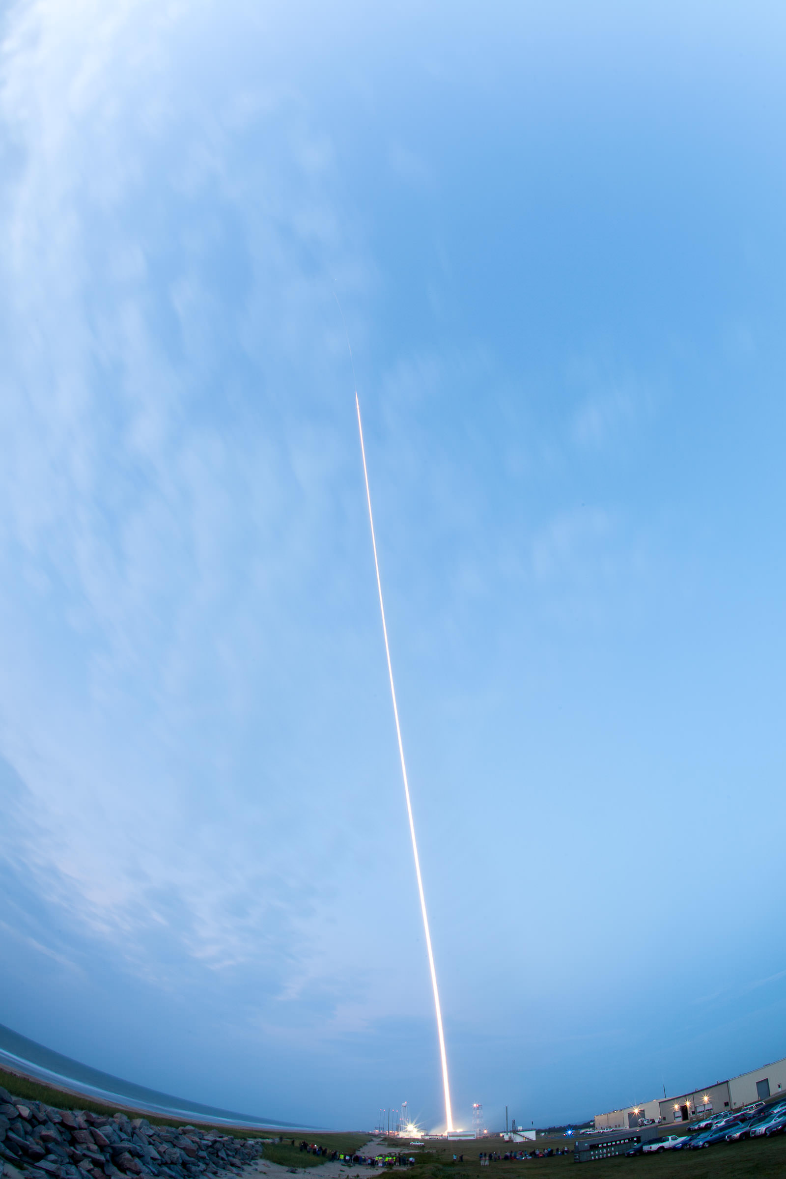
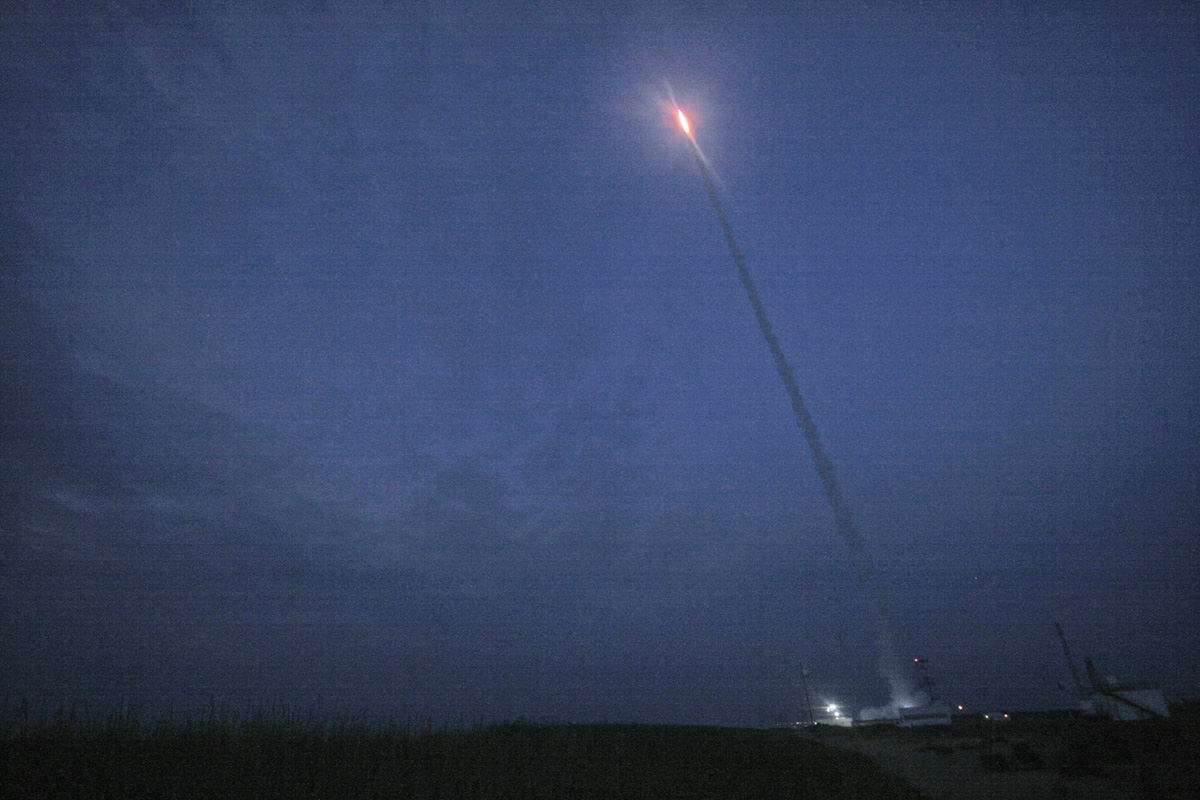
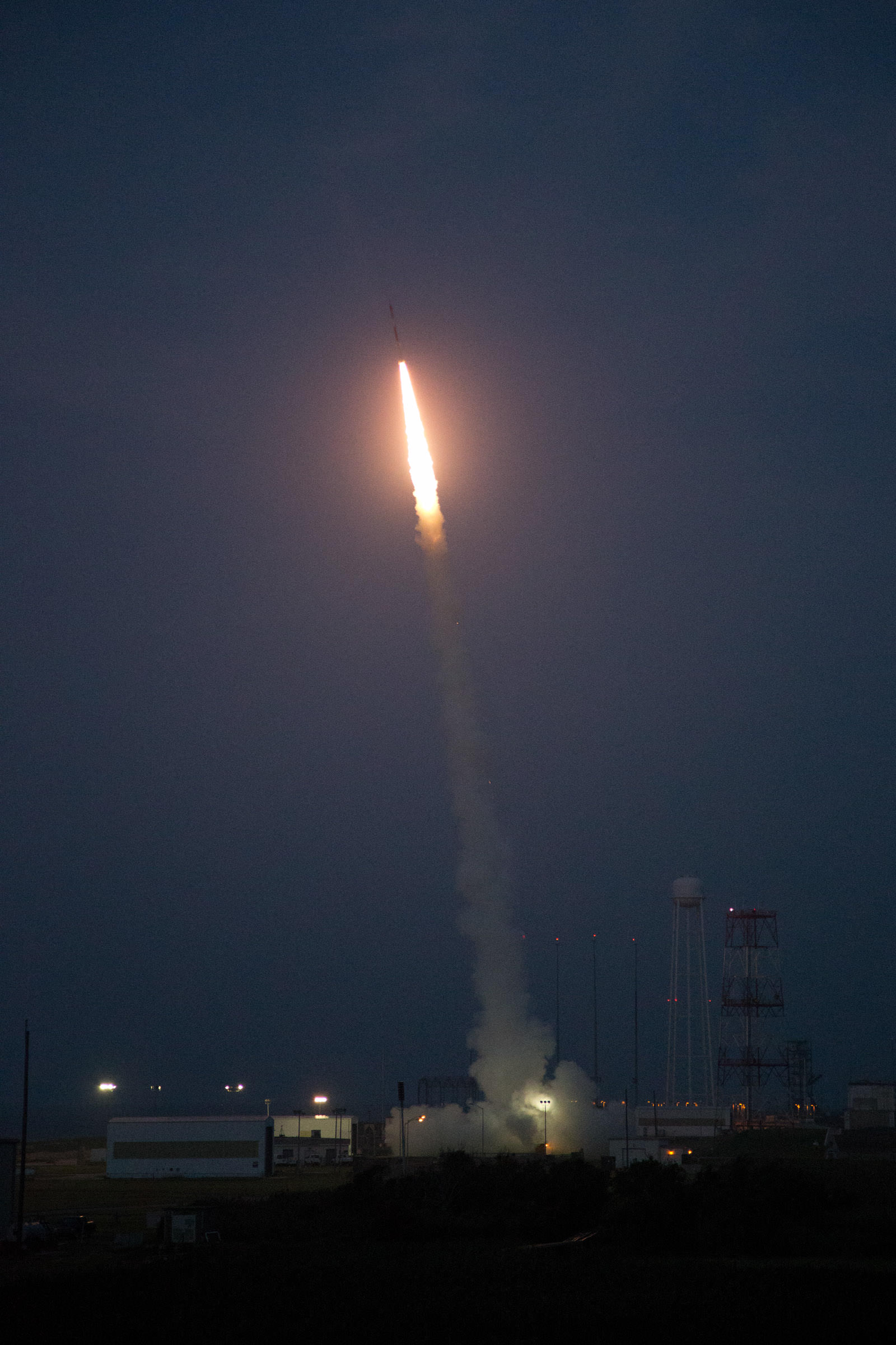
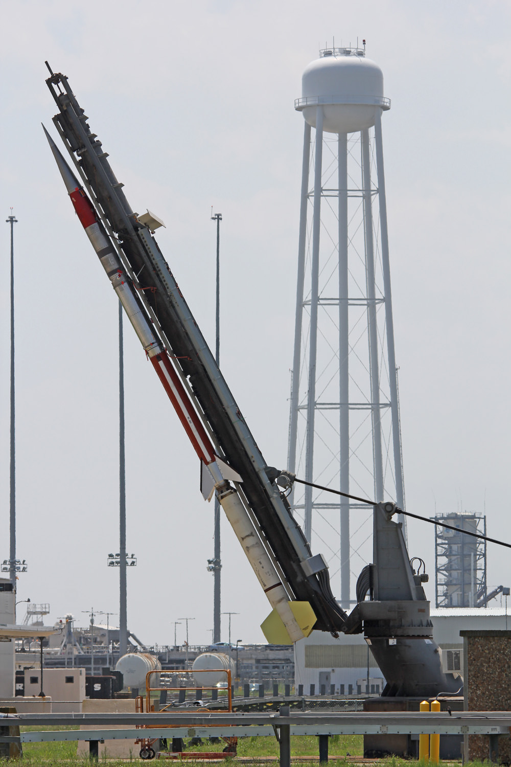
A Terrier-Improved Malemute suborbital rocket carrying experiments developed by university students nationwide in the RockSat-X program was successfully launched at 6 a.m. EDT August 13. Credit: NASA
A Terrier-Improved Malemute suborbital rocket carrying experiments developed by university students nationwide in the RockSat-X program was successfully launched at 6 a.m. EDT August 13. Credit: NASA/Allison Stancil Watch the cool Video below
[/caption]
WALLOPS ISLAND, VA – A nearly 900 pound complex payload integrated with dozens of science experiments created by talented university students in a wide range of disciplines and from all across America streaked to space from NASA’s beachside Wallops launch complex in Virginia on August 13 – just before the crack of dawn.
The RockSat-X science payload blasted off atop a Terrier-Improved Malemute suborbital sounding rocket at 6 a.m. from NASA’s Wallops Flight Facility along the Eastern Shore of Virginia.
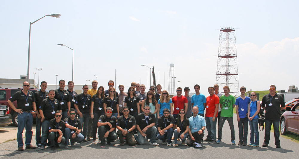
As a research scientist myself it was thrilling to witness the thunderous liftoff standing alongside more than 40 budding aerospace students brimming with enthusiasm for the chance to participate in a real research program that shot to space like a speeding bullet.
“It’s a hands on, real world learning experience,” Chris Koehler told Universe Today at the Wallops launch pad. Koehler is Director of the Colorado Space Grant Consortium that manages the RockSat-X program in a joint educational partnership with NASA.
The hopes and dreams of everyone was flying along.
Here’s a cool NASA video of the RockSat-X Aug. 13 launch:
The students are responsible for conceiving, managing, assembling and testing the experiments, Koehler told me. Professors and industrial partners mentor and guide the students.
RockSat-X is the third of three practical STEM educational programs where the students master increasingly difficult skills that ultimately result in a series of sounding rocket launches.
“Not everything works as planned,” said Koehler. “And that’s by design. Some experiments fail but the students learn valuable lessons and apply them on the next flight.”
“The RockSat program started in 2008. And it’s getting bigger and growing in popularity every year,” Koehler explained.
August 13 launch of RockSat-X student science payload atop a Terrier-Improved Malemute suborbital at 6 a.m. EDT from NASA Wallops. Credit: Ken Kremer/kenkremer.com
The 2013 RockSat-X launch program included participants from seven universities, including the University of Colorado at Boulder; the University of Puerto Rico at San Juan; the University of Maryland, College Park; Johns Hopkins University, Baltimore, Md.; West Virginia University, Morgantown; University of Minnesota, Twin Cities; and Northwest Nazarene University, Nampa, Idaho.
We all watched as a group and counted down the final 10 seconds to blastoff just a few hundred yards (meters) away from the launch pad – Whooping and hollering as the first stage ignited with a thunderous roar. Then the second stage flash – and more yelling and screams of joy! – – listen to the video.
Moments later we saw the first stage plummeting and heard a loud thud as it crashed into the ocean just 10 miles or so offshore.
A Terrier-Improved Malemute suborbital rocket carrying experiments developed by university students nationwide in the RockSat-X program was successfully launched at 6 a.m. EDT August 13. Credit: NASA/Brea Reeves
For most of the students -ranging from freshman to seniors – it was their first time seeing a rocket launch.
“I’m so excited to be here at NASA Wallops and see my teams experiment reach space!” said Hector, one of a dozen aerospace students who journeyed to Wallops from Puerto Rico.
Local Wallops area spectators and tourists told me they could hear the rocket booming from viewing sites more than 10 miles away.
Others who ‘overslept’ were awoken by the rocket thunder and houses shaking.
Suborbital rockets still make for big bangs!
The Puerto Rican students very cool experiment aimed at capturing meteorite particles in space using 6 cubes of aerogel that were extended out from the rocket as it descended back to Earth, said Oscar Resto, Science Instrument specialist and leader of the Puerto Rican team during an interview at the launch complex.
“Seeing this rocket launch was the best experience of my life,” Hector told me. “This was my first time visiting the mainland. I hope to come back again!”
Another team of 7 students from Northwest Nazarene University (NNU), Idaho aimed to investigate the durability of the world’s first physically flexible integrated chips.
“Our experiment tested the flexibility of integrated circuit chips in the cryogenic environment of space,” Prof Stephen Parke of NNU, Idaho, told Universe Today in an interview at the launch pad.
“The two year project is a collaboration with chipmaker American Semiconductor, Inc based in Boise, Idaho.”
“The chips were mechanically and electrically exercised, or moved, during the flight under the extremely cold conditions in space – of below Minus 50 C – to test whether they would survive,” Parke told me.
The 44 foot long, two stage rocket flew on a parabolic arc and a southeasterly trajectory. The 20 foot RockSat-X payload soared to an altitude of approximately 94 miles above the Atlantic Ocean.
More than 40 University students and mentors participating in the Aug. 13 RockSat-X science payload pose for post launch photo op at NASA Wallops Island, VA, launch complex that launched their own developed experiments to space. Credit: Ken Kremer/kenkremer.com
Telemetry and science data was successfully transmitted and received from the rocket during the flight.
The payload then descended back to Earth, deployed a 24 foot wide parachute and splashed down in the Atlantic Ocean some 90 miles offshore from Wallops Flight Facility. Overall the mission lasted about 20 minutes.
A commercial fishing boat hauled in the payload and brought it back to Wallops about 7 hours later.
By 2 p.m. the RockSat-X payload was back onsite at the Wallops ‘Rocket Factory’.
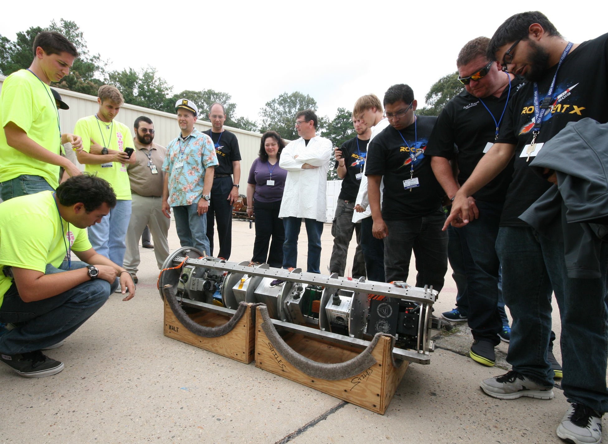
Rocket science university students get ready to tear apart the RockSat-X science payload after recovery from Atlantic Ocean splashdown following Aug. 13 rocket blastoff from NASA Wallops Flight Facility, VA. Credit: Ken Kremer/kenkremer.com
And I was on-hand as the gleeful students began tearing it apart to disengage their individual experiments to begin a week’s long process of assessing the outcome, analyzing the data and evaluating what worked and what failed. See my photos.
Rocket science university students from Puerto Rico pose for post flight photo op with their disengaged science experiment seeking to capture meteorite particles from space aboard Terrier-Improved Malemute sounding rocket that launched on Aug. 13 at 6 a.m. from NASA Wallops Flight Facility, VA. Credit: Ken Kremer/kenkremer.com
Included among the dozens of custom built student experiments were HD cameras, investigations into crystal growth and ferro fluids in microgravity, measuring the electron density in the E region (90-120km), aerogel dust collection on an exposed telescoping arm from the rockets side, effects of radiation damage on various electrical components, determining the durability of flexible electronics in the cryogenic environment of space and creating a despun video of the flight.
Indeed we already know that not every experiment worked. But that’s the normal scientific method – ‘Build a little, fly a little’.
New students are already applying to the 2014 RockSat program. And some of these students will return next year with thoughtful upgrades and new ideas!
The launch was dedicated in memory of another extremely bright young student named Brad Mason, who tragically passed away two weeks ago. Brad was a beloved intern at NASA Wallops this summer and a friend. Brad’s name was inscribed on the side of the rocket. Read about Brad at the NASA Wallops website.
…………….
Learn more about Suborbital science, Cygnus, Antares, LADEE, MAVEN and Mars rovers and more at Ken’s upcoming presentations
Sep 5/6/16/17: LADEE Lunar & Antares/Cygnus ISS Rocket Launches from Virginia”; Rodeway Inn, Chincoteague, VA, 8 PM
Oct 3: “Curiosity, MAVEN and the Search for Life on Mars – (3-D)”, STAR Astronomy Club, Brookdale Community College & Monmouth Museum, Lincroft, NJ, 8 PM
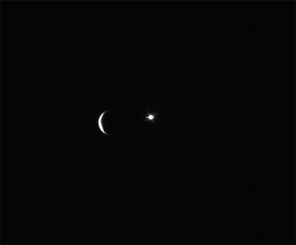
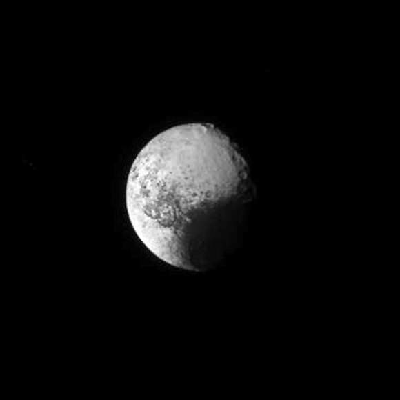
Animation of Iapetus briefly blocking a distant bright object. (NASA/JPL-Caltech/SSI. Assembled by Jason Major.)
It’s a cosmic cover-up! No, don’t put your tinfoil* hats on, this isn’t a conspiracy — it’s just Saturn’s moon Iapetus drifting in front of the bright star Gamma Orionis (aka Bellatrix) captured on Cassini’s narrow-angle camera on August 10, 2013.
Such an event is called an occultation, a term used in astronomy whenever light from one object is blocked by another — specifically when something visually larger moves in front of something apparently smaller. (The word occult means to hide or conceal… nothing mystical implied!)
The animation above was assembled from 19 raw images publicly available on the JPL Cassini mission site, stacked in Photoshop and exported as a gif. They’ve been rotated 90º from the originals but otherwise they’re right from Cassini’s camera.
Iapetus, seen above as just a thin crescent, is best known for its two-toned appearance. One half of the 914-mile-wide moon is bright and icy, the other coated with a layer of dark reddish material, giving it a real “yin-yang” appearance. (Ok, I guess that’s a little mystical. But purely coincidental.)
The Tao of Iapetus (NASA/JPL-Caltech/SSI)
It’s thought that the dark material originates from a more distant moon, Phoebe, which is being pelted by micrometeorites and shedding its surface out into orbit around Saturn, which eventually gets scooped up by the backwards-orbiting Iapetus.
The difference in albedo affects how Iapetus absorbs solar radiation too, causing the water ice beneath the darker material to evaporate over the course of its 79-Earth-day rotation and migrate around its surface, creating a sort of positive feedback loop.
While neat to look at, occultations are important to science because they provide a way to briefly peer into a world’s atmosphere (or in a small moon’s case, exosphere). Watching how light behaves as it passes behind the limb of a planet or moon lets researchers learn details of the air around it — however tenuous — pretty much for free… no probes or flybys needed!
The occulted star above is Bellatrix, the 1.6-magnitude star that marks Orion’s left shoulder.
Iapetus orbits Saturn at the considerable distance of 2,212,889 miles (3,561,300 km). Learn more about Iapetus here, and as always you can find more fantastic Cassini images from Carolyn Porco’s team at the Space Science Institute in Boulder, Colorado at the CICLOPS site here.
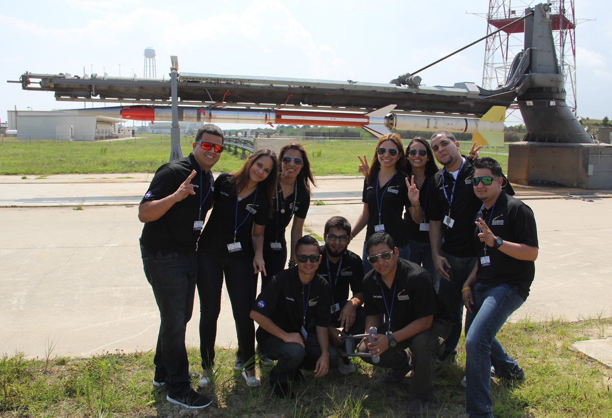
Rocket science university students from Puerto Rico pose for photo op with the Terrier-Improved Malemute sounding rocket that will launch their own developed RockSat-X science experiments to space on Aug. 13 at 6 a.m. from NASA Wallops Flight Facility, VA. Credit: Ken Kremer/kenkremer.com
Rocket science university students from Puerto Rico pose for photo op with the Terrier-Improved Malemute sounding rocket that will launch their own developed RockSat-X science experiments to space on Aug. 13 at 6 a.m. from NASA Wallops Flight Facility, VA.
Credit: Ken Kremer/kenkremer.com[/caption]
WALLOPS ISLAND, VA – How many of you have dreamed of flying yourselves or your breakthrough experiments to the High Frontier? Well if you are a talented student, NASA may have a ticket for you.
A diverse group of highly motivated aerospace students from seven universities spread across the United States have descended on NASA’s Wallops Flight Facility along the Eastern Shore of Virginia to fulfill the dream of their lifetimes – launching their very own science experiments aboard a rocket bound for space.
I met the thrilled students and professors today beside their rocket at the Wallops Island launch pad.
On Aug 13, after years of hard work, an impressive array of research experiments developed by more than 40 university students will soar to space on the RockSat-X payload atop a 44-foot tall Terrier-Improved Malemute suborbital sounding rocket at 6 a.m. EDT.
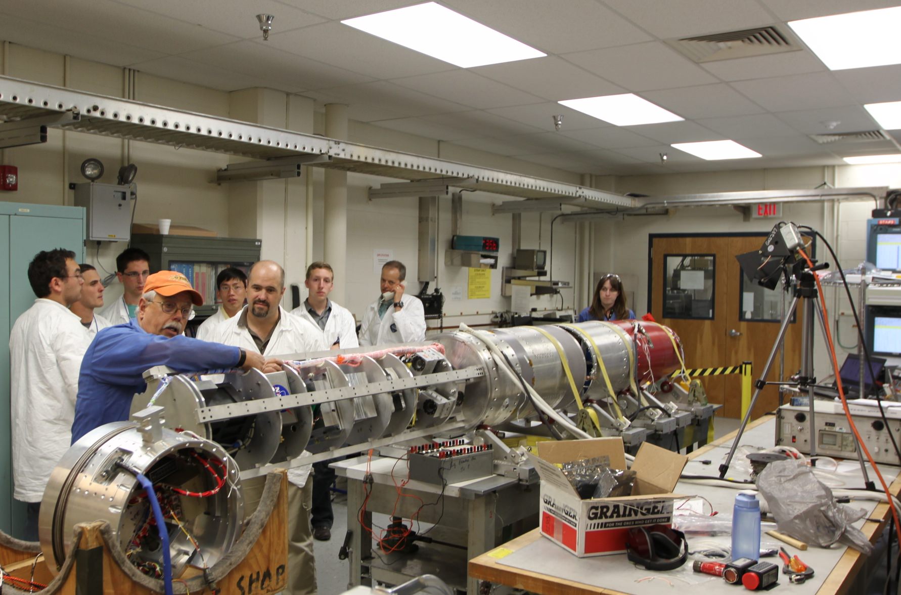
Students from Northwest Nazarene University observe the pre-integration of their experiment into the RockSat-X payload at the NASA Wallops Flight Facility in June. Students from seven universities are participating in the program and will attend the launch on August 13. Credit: NASA/K. Koehler
The two stage rocket will rapidly ascend on a southeasterly trajectory to an altitude of some 97 miles and transmit valuable data in-flight during the 12-minute mission.
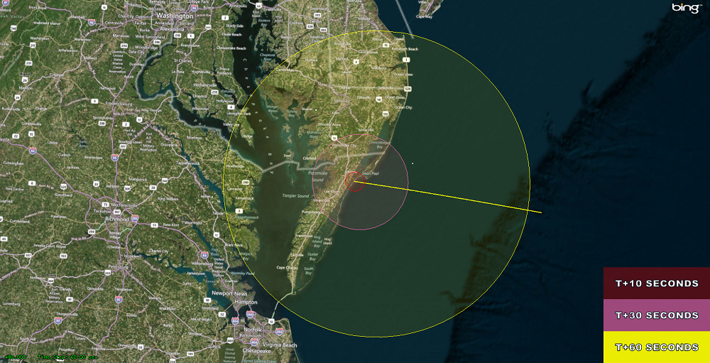
The launch will be visible to spectators in parts of Virginia, Maryland and Delaware, and perhaps a bit beyond. Check out the visibility map below.
The RockSat-X flight profile and visibility map. RockSat-X is scheduled to launch from NASA’s Wallops Flight Facility, VA on Aug. 13 at 6.a.m. EDT Credit: NASA
If you’re available, try venturing out to watch it. The available window lasts until 10 a.m. EDT if needed.
The students will put their classroom learning to the test with experiments and instruments built by their own hands and installed on the 20 foot long RockSat-X payload. The integrated payload accounts for nearly half the length of the Terrier Malamute suborbital rocket. It’s an out of this world application of the scientific method.
Terrier-Improved Malemute sounding rocket erected for launch of student experiments on RockSat-X payload on Aug. 13 at 6 a.m. from NASA Wallops Flight Facility, VA. Credit: Ken Kremer/kenkremer.comIncluded among the dozens of custom built student experiments are HD cameras, investigations into crystal growth and ferro fluids in microgravity, measuring the electron density in the E region (90-120km), aerogel dust collection on an exposed telescoping arm from the rockets side, effects of radiation damage on various electrical components, determining the durability of flexible electronics in the cryogenic environment of space and creating a despun video of the flight.
At the conclusion of the flight, the payload will descend to Earth via a parachute and splash down in the Atlantic Ocean approximately 86 miles offshore from Wallops.
Commercial fishing ships under contract to NASA will then recover the RockSat-X payload and return it to the students a few hours later, NASA spokesman Keith Koehler told Universe Today.
They will tear apart the payload, disengage their experiments and begin analyzing the data to see how well their instruments performed compared to the preflight hypotheses’.
RockSat-X is a joint educational activity between NASA and the Colorado Space Grant Consortium. It is the third of three practical STEM educational programs where the students must master increasingly difficult skill level requirements leading to a series of sounding rocket liftoffs.
In mid-June, some 50 new students participated in the successful ‘RockOn’ introductory level payload launch from Wallops using a smaller Terrier-Improved Orion rocket.
“The goal of the RockSat-X program is to provide students a hands-on experience in developing experiments for space flight,” said Chris Koehler, Director of the Colorado Space Grant Consortium.
“This experience allows these students to apply what they have learned in the classroom to a real world hands-on project.”
The students participating in this year’s RockSat-X launch program hail from the University of Colorado at Boulder; the University of Puerto Rico at San Juan; the University of Maryland, College Park; Johns Hopkins University, Baltimore, Md.; West Virginia University, Morgantown; University of Minnesota, Twin Cities; and Northwest Nazarene University, Nampa, Idaho.
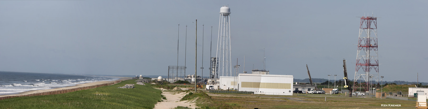
Panoramic view of the NASA Wallops Flight Facility launch range at Virginia’s Eastern Shore during prior launch of two suborbital sounding rockets as part of the Daytime Dynamo mission. RockSat-X payload will launch on a Terrier-Improved Malemute sounding rocket. Credit: Ken Kremer/kenkremer.com
Some of these students today could well become the pioneering aerospace industry leaders of tomorrow!
In the event of a delay forced by weather or technical glitches, August 14 is the backup launch day.
A great place to witness the blastoff is from the NASA Wallops Visitor Center, offering a clear view to the NASA launch range.
It opens at 5 a.m. on launch day and is a wonderful place to learn about NASA missions – especially the pair of exciting and unprecedented upcoming launches of the LADEE lunar science probe to the moon and the Cygnus cargo carrier to the ISS in September.
Both LADEE and Cygnus are historic first of their kind flights from NASA Wallops.
Live coverage of the launch is available via UStream beginning at 5 a.m. on launch day at:
http://www.ustream.tv/channel/nasa-tv-wallops
…………….
Learn more about Suborbital Science, Cygnus, Antares, LADEE, MAVEN and Mars rovers and more at Ken’s upcoming presentations
Aug 12/13: “RockSat-X Suborbital Launch, LADEE Lunar & Antares Rocket Launches from Virginia”; Rodeway Inn, Chincoteague, VA, 8 PM
Sep 5/6/16/17: LADEE Lunar & Antares/Cygnus ISS Rocket Launches from Virginia”; Rodeway Inn, Chincoteague, VA, 8 PM
Oct 3: “Curiosity, MAVEN and the Search for Life on Mars – (3-D)”, STAR Astronomy Club, Brookdale Community College & Monmouth Museum, Lincroft, NJ, 8 PM
More than 40 University students participating in the Aug. 13 RockSat-X science payload pose for photo op with the Terrier-Improved Malemute sounding rocket that will launch their own experiments to space from NASA Wallops Flight Facility, VA. Credit: Ken Kremer/kenkremer.com
Gather round the internets for another episode of the Weekly Space Hangout. Where our experienced team of journalists, astronomers and astronomer-journalists bring you up to speed on the big happenings in the universe of space and astronomy.
Our team this week:
Reporters: Casey Dreier, David Dickinson, Amy Shira Teitel, Sondy Springmann, Nicole Gugliuci
We record the Weekly Space Hangout every Friday at Noon Pacific, 3 pm Eastern. Join us live here on Universe Today, over on our YouTube account, or on Google+. Or you can watch the archive after the fact.
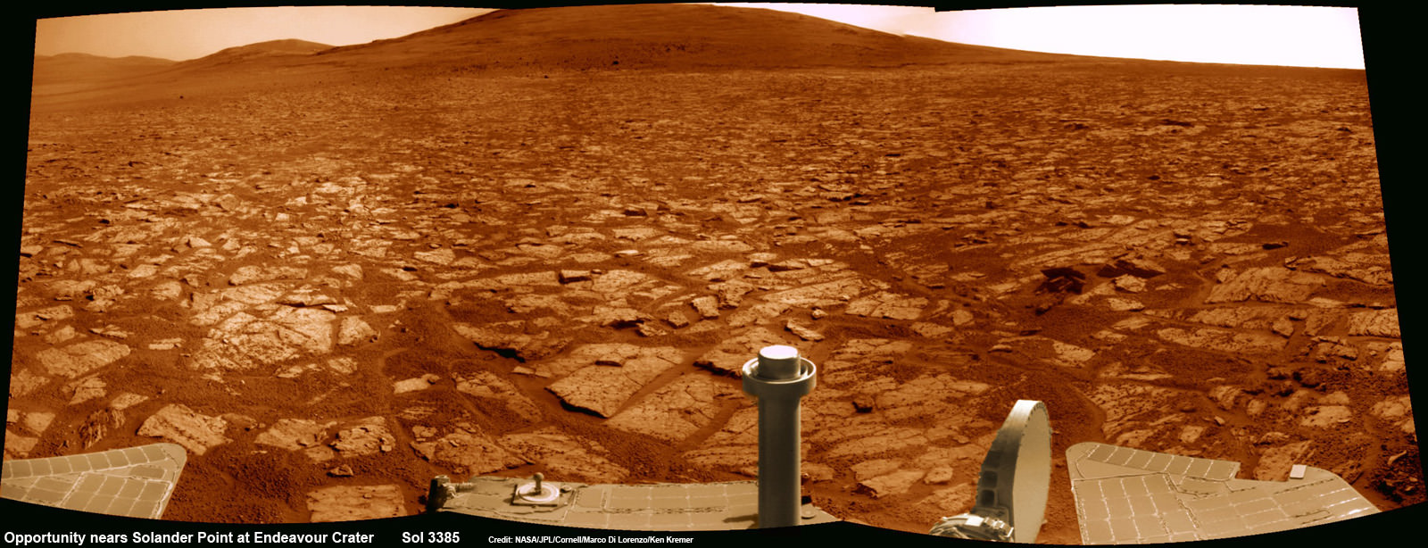
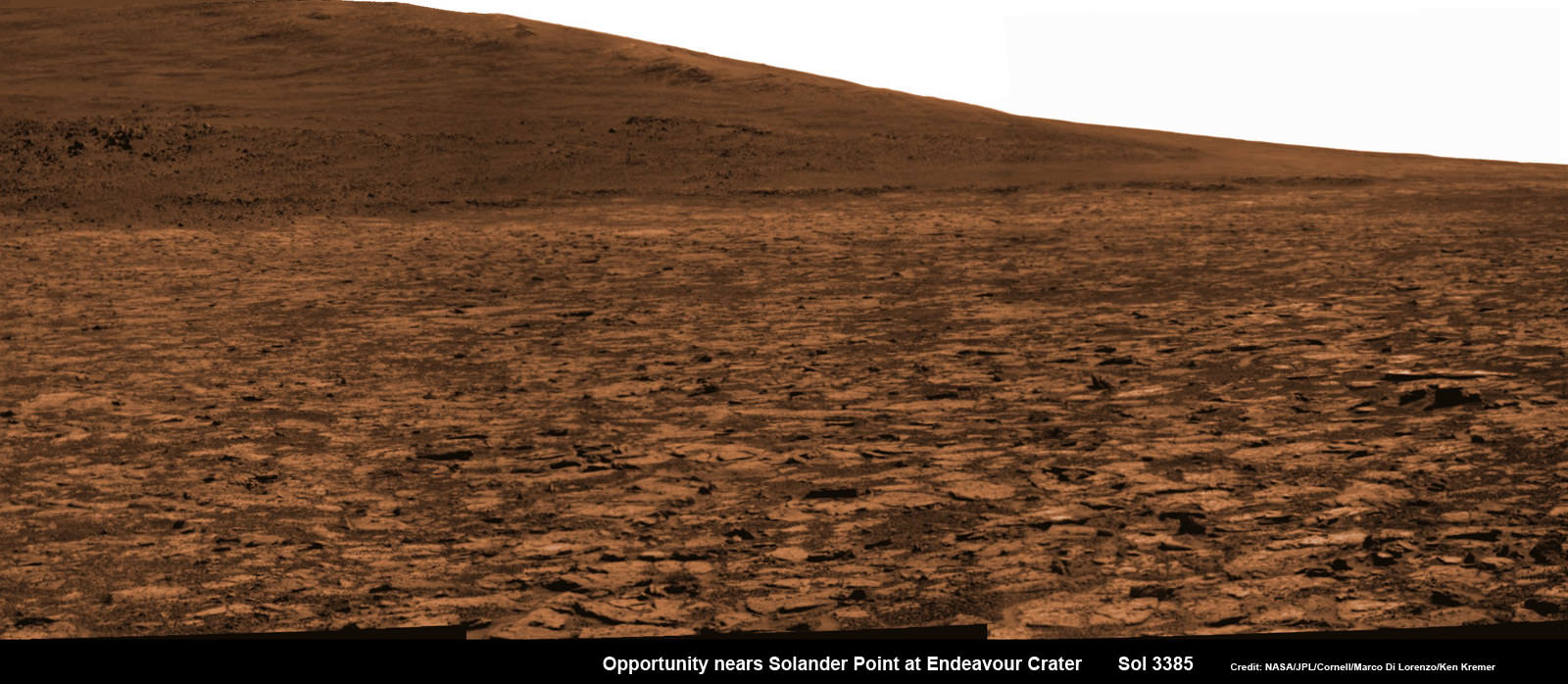
Opportunity rover’s 1st mountain climbing goal is dead ahead in this up close view of Solander Point along the eroded rim of Endeavour Crater. Opportunity will soon ascend the mountain in search of minerals signatures indicative of a past Martian habitable environment. This navcam panoramic mosaic was assembled from raw images taken on Sol 3385 (Aug 2, 2013). Credit: NASA/JPL/Cornell/Marco Di Lorenzo/Ken Kremer (kenkremer.com)
Opportunity rover’s 1st mountain climbing goal is dead ahead in this up close view of Solander Point at Endeavour Crater. Opportunity will ascend the mountain looking for clues indicative of a Martian habitable environment. This navcam panoramic mosaic was assembled from raw images taken on Sol 3385 (Aug 2, 2013).
Credit: NASA/JPL/Cornell/Marco Di Lorenzo/Ken Kremer (kenkremer.com)[/caption]
NASA’s most powerful Mars orbiter has been given the green light today (Aug. 5) to capture new high resolution spectral scans that are absolutely crucial for directing the long lived Opportunity rover’s hunt for signatures of habitability atop the intriguing mountain she will soon ascend.
In a plan only recently approved by NASA, engineers are aiming the CRISM mineral mapping spectrometer aboard the Mars Reconnaissance Orbiter (MRO) circling overhead to collect high resolution survey scans of Solander Point – Opportunity’s 1st mountain climbing goal along the rim of huge Endeavour Crater.
“New CRISM observations centered over Solander Point will be acquired on Aug. 5, 2013,” Ray Arvidson told Universe Today exclusively. Arvidson is the mission’s deputy principal scientific investigator from Washington University in St. Louis, Mo.
NASA’s decade old rover Opportunity is about to make ‘landfall’ at the base of Solander Point, the Martian mountain she will scale in search of the chemical ingredients that could sustain Martian microbes.
So the new spectral data can’t come back to Earth soon enough.
Currently, the science team lacks the same quality of high resolution CRISM data from Solander Point that they had at a prior stop at Cape York. And that data was crucial because it allowed the rover to be precisely targeted – and thereby discover a habitable zone, Arvidson told me.
“CRISM collected lots of overlapping measurements at Cape York to sharpen the image resolution to 5 meters per pixel to find the phyllosilicate smectite [clay minerals] signatures at Matejivic Hill on Cape York.”
“We don’t have that at Solander Point. We only have 18 meters per pixel data. And at that resolution you can’t tell if the phyllosilicate smectite [clay minerals] outcrops are present.”
Today’s new survey from Mars orbit will vastly improve the spectral resolution – from 18 meters per pixel down to 5 meters per pixel.
“5 meter per pixel CRISM resolution is expected in the along-track direction over Solander Point by commanding the gimbaled optical system to oversample that much,” Arvidson explained.
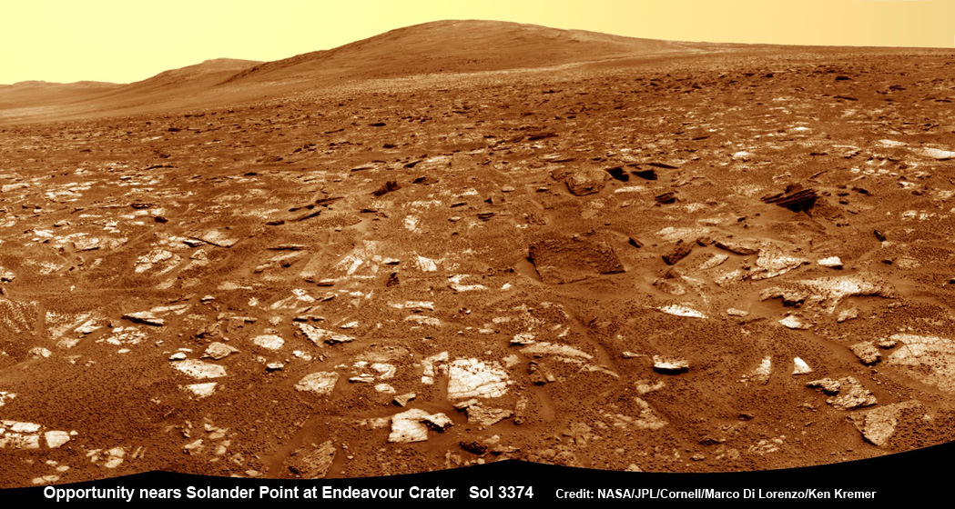
Opportunity rover’s view from very near the foothills of Solander Point looking along the rim and vast expanse of Endeavour Crater. Solander Point is the 1st Martian Mountain NASA’s Opportunity will climb and the rovers next destination. Solander Point may harbor clay minerals indicative of a past Martian habitable environment. This navcam mosaic was assembled from raw images taken on Sol 3374 (July 21, 2013). Credit: NASA/JPL/Cornell/Marco Di Lorenzo/Ken Kremer (kenkremer.com)
The new CRISM spectral survey from Mars is essential to enable the science team to carefully study the alien, unexplored terrain in detail and locate the clay minerals and other water bearing minerals, even before the rover arrives.
Clay minerals form in neutral pH water conducive to life.
Opportunity would then be commanded to drive to preselected sites to conduct “ground truth” forays at Solander.
That’s just like was done at Cape York and the “Esperance” rock loaded with clay minerals that turned into one of the “Top 5 discoveries of the mission” according to Arvidson and Steve Squyres, Opportunity’s Science Principal Investigator of Cornell.
But it took some cajoling and inter team negotiations to convince everyone to move forward with the special but crucial CRISM imaging plan.
Since MRO is getting on in age – it launched in 2005 – NASA and the spacecraft managers have to carefully consider special requests such as this one which involves slewing the MRO spacecraft instruments and therefore entails some health risks to the vehicle.
“CRISM has been operating at Mars since 2006 and sometimes the optics on a gimble have actuators that get stuck a little bit and don’t sweep as fully as planned.”
Nevertheless, Arvidson told me a few weeks ago he was hopeful to get approval.
“I suspect I can talk the team into it.”
And eventually he did! And informed me for the readers of Universe Today.
The fact that the Opportunity scientists already scored a ‘Science Home Run’ with their prior CRISM targeting request at Cape York certainly aided their cause immensely.
The new approved CRISM measurements due to be captured today will give Opportunity the best chance to be targeted to the most promising mineral outcrops, and as quickly as possible.
“With the coordinated observations from CRISM and Opportunity we will go into Solander Point a lot smarter!”
“And we’ll have a pretty good idea of what to look for and where,” Arvidson told me.
Opportunity snap up close view of the base of Solander Point and mountain slopes she will ascend soon. This hi res pancam camera mosaic was assembled from raw images taken on Sol 3385 (Aug 2, 2013). Credit: NASA/JPL/Cornell/ASU/Marco Di Lorenzo/Ken Kremer (kenkremer.com)
Today marks Opportunity’s 3389th Sol or Martian day roving Mars. Merely 90 days were expected!
Having completed her investigation of the rocky crater plains, the rover continues to drive south.
Any day now Opportunity will drive onto the Bench surrounding Solander and start a new phase of the mission.
Since she basically arrived at Solander with plenty of power and ahead of schedule prior to the onset of the 6th Martian winter, the robot has some spare time to investigate the foothills before ascending the north facing slopes.
“We will be examining the bench and then working our way counterclockwise to reach the steep slopes associated with the Noachian outcrops that are part of the Endeavour rim,” Arvidson said.
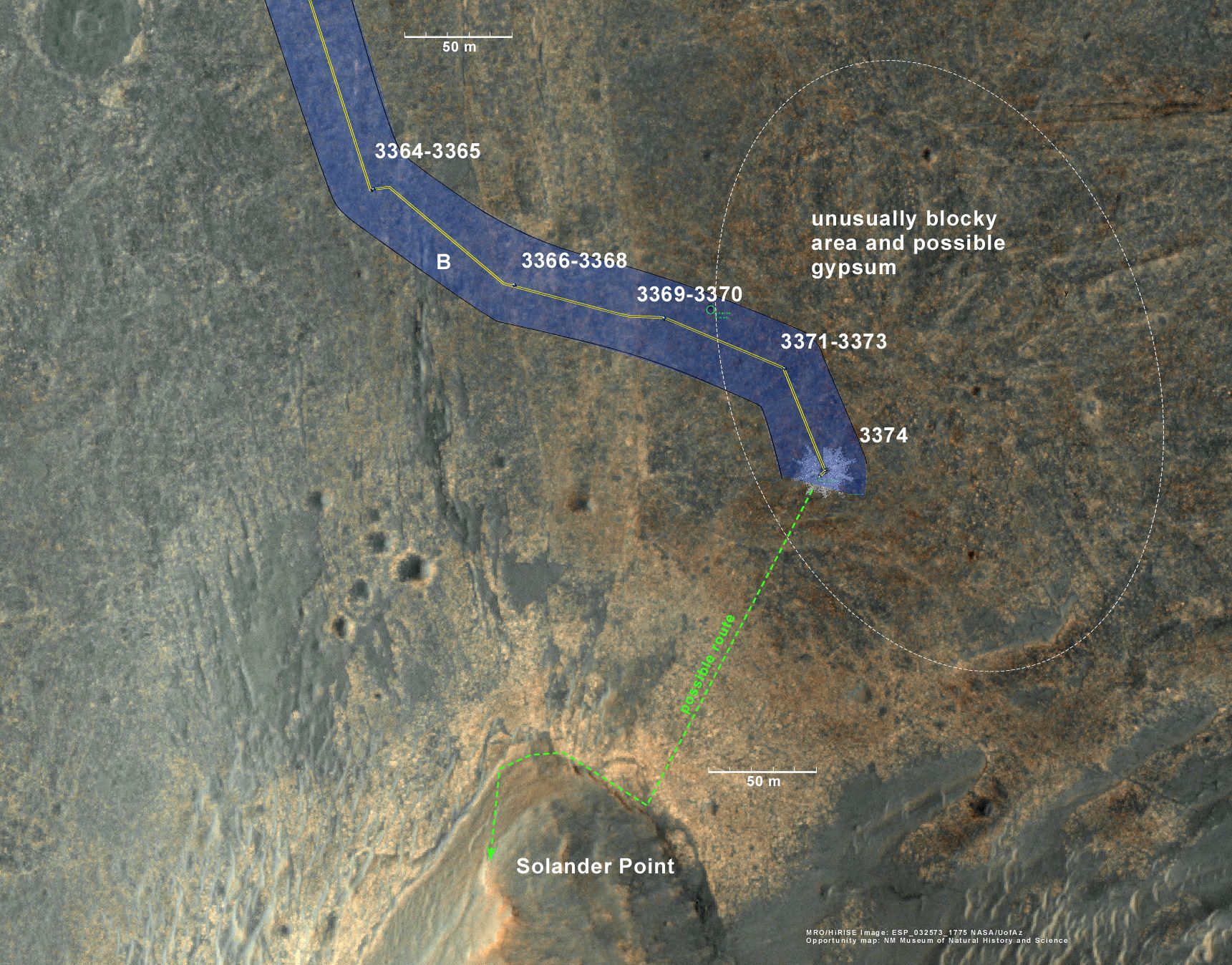
Ken Kremer Opportunity rover location in the latest MRO/HiRISE color image. The green line shows more or less the route we hope to take to the base of Solander point. Since it is only a couple of hundred meters away, we could be there is a couple of drives. Maybe by the end of next week. The label say “3374” but this is also roughly the location through 3379. Credit: NASA/JPL/Larry Crumpler
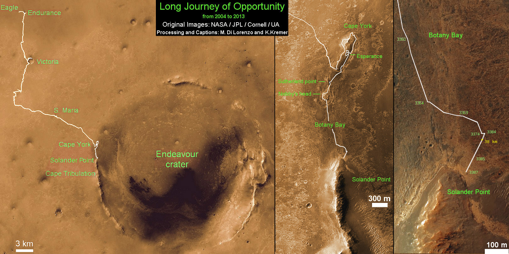
Traverse Map for NASA’s Opportunity rover from 2004 to 2013
This map shows the entire path the rover has driven during more than 9 years and over 3387 Sols, or Martian days, since landing inside Eagle Crater on Jan 24, 2004 to current location near foothills of Solander Point at the western rim of Endeavour Crater. Opportunity discovered clay minerals at Esperance – indicative of a habitable zone. Credit: NASA/JPL/Cornell/ASU/Marco Di Lorenzo/Ken Kremer
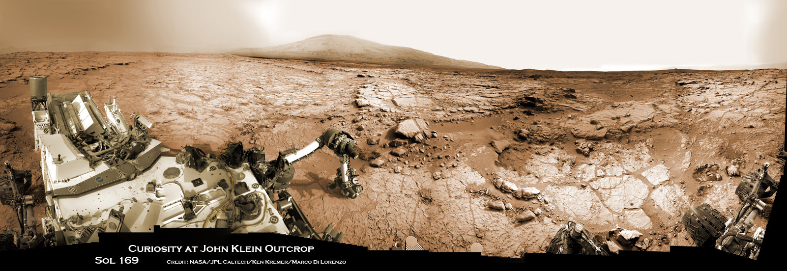
Curiosity accomplished Historic 1st drilling into Martian rock at John Klein outcrop on Feb 8, 2013 (Sol 182), shown in this context mosaic view of the Yellowknife Bay basin taken on Jan. 26 (Sol 169). The robotic arm is pressing down on the surface at John Klein outcrop of veined hydrated minerals – dramatically back dropped with her ultimate destination; Mount Sharp. Credit: NASA/JPL-Caltech/Ken Kremer/Marco Di Lorenzo
Curiosity accomplished Historic 1st drilling into Martian rock at John Klein outcrop on Feb 8, 2013 (Sol 182), shown in this context mosaic view of the Yellowknife Bay basin taken on Jan. 26 (Sol 169). The robotic arm is pressing down on the surface at John Klein outcrop of veined hydrated minerals – dramatically back dropped with her ultimate destination; Mount Sharp.
Credit: NASA/JPL-Caltech/Ken Kremer/Marco Di Lorenzo Story updated with further details[/caption]
NASA’s mega Mars rover Curiosity is celebrating 1 Year on the Red Planet since the dramatic landing on Aug. 6, 2012 by reveling in a string of groundbreaking science discoveries demonstrating that Mars could once have supported past life – thereby accomplishing her primary science goal – and with a promise that the best is yet to come!
“We now know Mars offered favorable conditions for microbial life billions of years ago,” said the mission’s project scientist, John Grotzinger of the California Institute of Technology in Pasadena.
“Curiosity has landed in an ancient river or lake bed on Mars,” Jim Green, Director of NASA’s Planetary Science Division, told Universe Today.
Curiosity is now speeding onwards towards Mount Sharp, the huge 3.4 mile (5. 5 km) mountain dominating the center of her Gale Crater landing site – and which is the primary destination of the mission.
During Year 1, Curiosity has transmitted over 190 gigabits of data, captured more than 71,000 images, fired over 75,000 laser shots to investigate the composition of rocks and soil and drilled into two rocks for sample analysis by the pair of state-of-the-art miniaturized chemistry labs housed in her belly – SAM & CheMin.
“From the sophisticated instruments on Curiosity the data tells us that this region could have been habitable in Mars’ distant past,” Green told me.
“This is a major step forward in understanding the history and evolution of Mars.”
And just in the nick of time for her 1 year anniversary, the car sized robot just passed the 1 mile (1.6 kilometer) driving mark on Aug. 1, or Sol 351.
Mount Sharp still lies roughly 5 miles (8 kilometers) distant – as the Martian crow flies.
“We will be on a general heading of southwest to Mount Sharp,” Jim Erickson, Curiosity Project Manager of NASA’s Jet Propulsion Laboratory (JPL), told Universe Today in an exclusive interview. See the NASA JPL route maps below.
“We have been going through various options of different planned routes.”
How long will the journey to Mount Sharp take?
“Perhaps about a year,” Erickson told me.
“We have put some new software – called autonav, or autonomous navigation – on the vehicle right after the conjunction period back in March 2013. This will increase our ability to drive.”
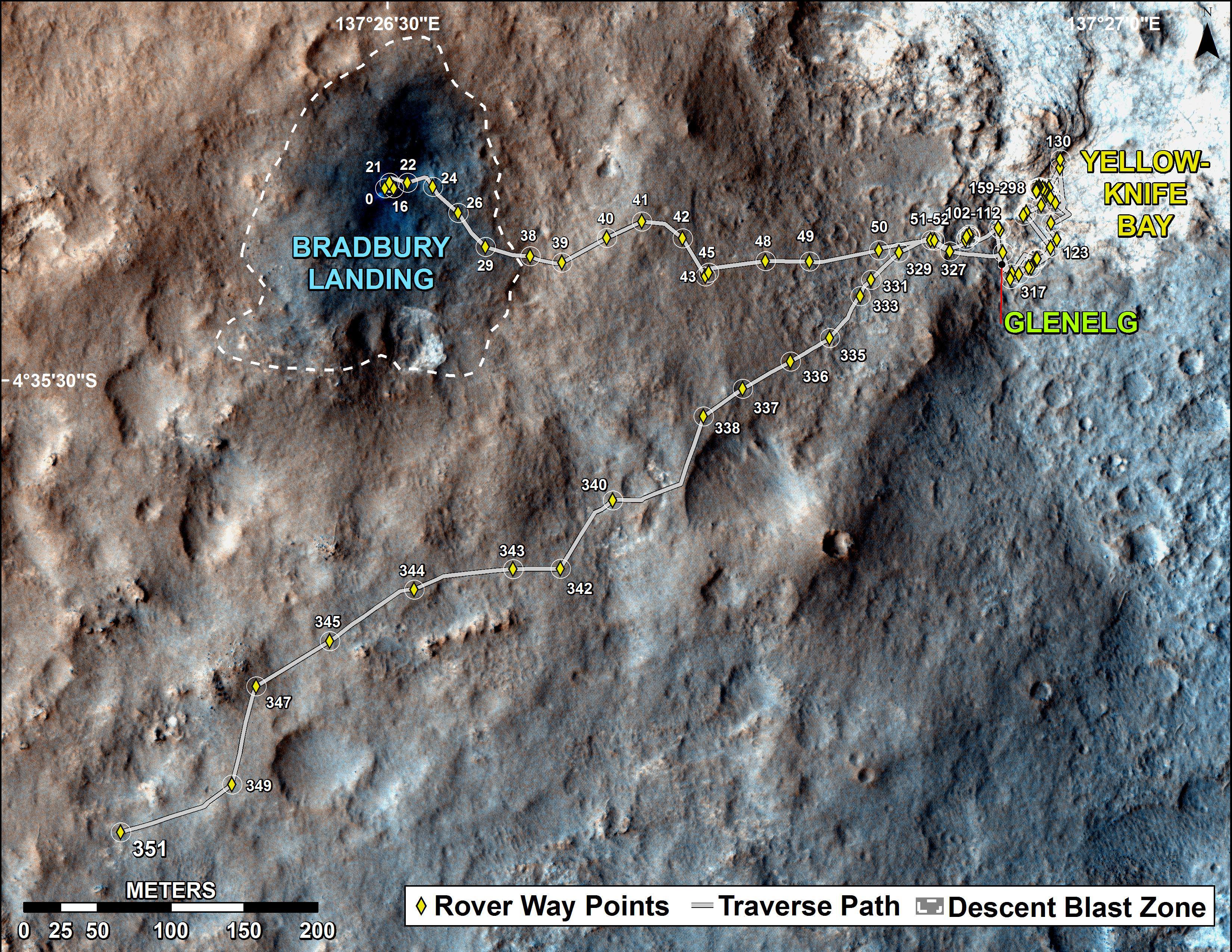
The total distance driven by NASA’s Mars rover Curiosity passed the one-mile mark a few days before the first anniversary of the rover’s landing on Mars. This map traces where Curiosity drove between landing at “Bradbury Landing” on Aug. 5, 2012, PDT, (Aug. 6, 2012 (Universal Time and EDT) and the position reached during the mission’s 351st Martian day, or sol, (Aug. 1, 2013). The Sol 351 leg added 279 feet (85.1 meters) and brought the odometry since landing to about 1.05 miles (1,686 meters). Credit: NASA/JPL-Caltech/Univ. of Arizona
“We are trying to make that significantly faster by bringing the new autonav online. That will help. But how much it helps really depends on the terrain.”
So far the terrain has not been problematical.
“Things are going very well and we have a couple of drives under our belt,” said Erickson, since starting the long trek to Mount Sharp about a month ago.
The lower reaches of Mount Sharp are comprised of exposed geological layers of sedimentary materials that formed eons ago when Mars was warmer and wetter, and much more hospitable to microscopic life.
“It has been gratifying to succeed, but that has also whetted our appetites to learn more,” says Grotzinger. “We hope those enticing layers at Mount Sharp will preserve a broad diversity of other environmental conditions that could have affected habitability.”
Indeed, Curiosity’s breakthrough discovery that the surface of Mars possesses the key chemical ingredients required to sustain microbial life in a habitable zone, has emboldened NASA to start mapping out the future of Mars exploration.
“NASA’s Mars program is back on track with the 2016 InSight lander and the 2020 rover,” Jim Green, Director of NASA’s Planetary Science Division, told Universe Today in an interview.
“Successes of our Curiosity — that dramatic touchdown a year ago and the science findings since then — advance us toward further exploration, including sending humans to an asteroid and Mars,” said NASA Administrator Charles Bolden in a statement.
“Wheel tracks now, will lead to boot prints later.”
Following the hair-raising touchdown using with the never before used sky-crane descent thrusters, the science team directed the 1 ton robot to drive to a nearby area of interesting outcrops on the Gale crater floor – at a place called Glenelg and Yellowknife Bay.
Along the way, barely 5 weeks after landing, Curiosity found a spot laden with rounded pebbles at the Hottah outcrop of concretions that formed in an ancient stream bed where hip deep liquid water once flowed rather vigorously.
In February 2013, Curiosity conducted the historic first ever interplanetary drilling into Red Planet rocks at the ‘John Klein’ outcrop inside Yellowknife Bay that was shot through with hydrated mineral veins of gypsum.
The Yellowknife Bay basin looks like a dried up river bed.
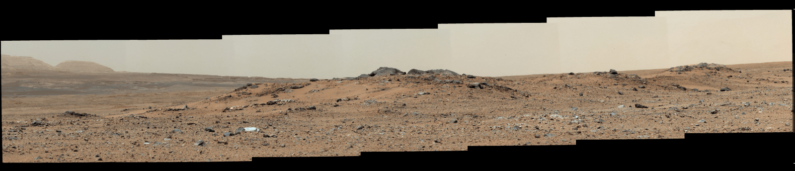
This scene combines seven images from the telephoto-lens camera on the right side of the Mast Camera (Mastcam) instrument on NASA’s Mars rover Curiosity on Sol 343 of the rover’s work on Mars (July 24, 2013). The center of the scene is toward the southwest. Credit: NASA/JPL-Caltech/Malin Space Science Systems
Analysis of pulverized portions of the gray colored rocky powder cored from the interior of ‘John Klein’ revealed evidence for phyllosilicates clay minerals that typically form in pH neutral water. These starting findings on the crater floor were unexpected and revealed habitable environmental conditions on Mars – thus fulfilling the primary science goal of the mission.
See herein our context panoramic mosaic from Sol 169 showing the robotic arm touching and investigating the Martian soil and rocks at ‘John Klein’.
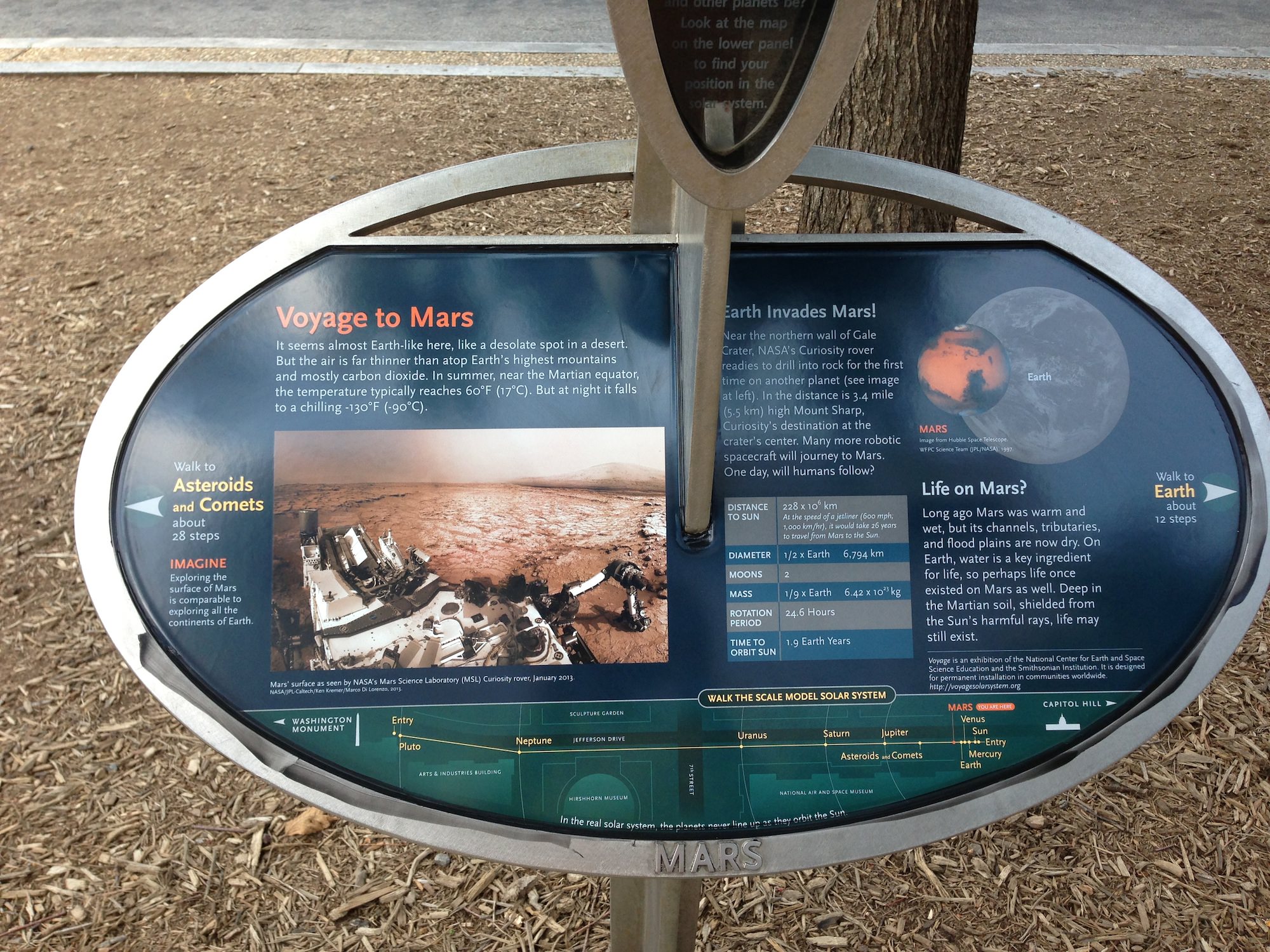
And if you take a visit to Washington, DC, you can see our panorama (assembled by Ken Kremer and Marco Di Lorenzo) on permanent display at a newly installed Solar System exhibit at the US National Mall in front of the Smithsonian National Air & Space Museum- details here.
A mosaic by the Mars Science Laboratory Curiosity rover, assembled by Ken Kremer and Marco Di Lorenzo is now part of the permanent Solar System Exhibit outside the National Air and Space Museum on the US National Mall in Washington, D.C. Image courtesy NCESSE.
“We have found a habitable environment [at John Klein] which is so benign and supportive of life that probably if this water was around, and you had been on the planet, you would have been able to drink it,” says Grotzinger, summing up the mission.
Curiosity captured unique and rare view of tiny Martian moons Phobos & Deimos together on Sol 351 (Aug 1, 2013). Look close and see craters on pockmarked Phobos. Credit: NASA/JPL/MSSS, contrast enhanced by Marco Di Lorenzo and Ken KremerOn the long road to Mount Sharp, Curiosity will make occasional stops for science.
This past week she captured rare sky watching images of the diminutive Martian moons – Phobos and Deimos – together!
Meanwhile, Curiosity’s 10 year old sister rover Opportunity Is trundling merrily along and will arrive shortly at her own mountain climbing goal on the opposite of Mars.
And NASA’s next Mars orbiter called MAVEN (for Mars Atmosphere and Volatile Evolution), has just arrived intact at the Kennedy Space Center after a cross country trip aboard a USAF C-17.
Technicians at Kennedy will complete final preparations for MAVEN’s blastoff to the Red Planet on Nov. 18 from the Florida Space Coast atop an Atlas V rocket.
On Tuesday, Aug 6, NASA will broadcast a half day of new programming on NASA TV commemorating the landing and discussing the science accomplished so far and what’s coming next.
And stay tuned for more astonishing discoveries during ‘Year 2’ on the Red Planet from our intrepid rover Curiosity – Starting Right Now !
Curiosity Route Map From ‘Glenelg’ to Mount Sharp
This map shows where NASA’s Mars rover Curiosity landed in August 2012 at “Bradbury Landing”; the area where the rover worked from November 2012 through May 2013 at and near the “John Klein” target rock in the “Glenelg” area; and the mission’s next major destination, the entry point to the base of Mount Sharp. Credit: NASA/JPL-Caltech/Univ. of Arizona