Illustration of the Kepler spacecraft. Kepler's mission is over, but all of the exoplanets it found still need to be confirmed in follow-up observations. (NASA/Kepler mission/Wendy Stenzel)
Kepler may not be hanging up its planet-hunting hat just yet. Even though two of its four reaction wheels — which are crucial to long-duration observations of distant stars — are no longer operating, it could still be able to seek out potentially-habitable exoplanets around smaller stars. In fact, in its new 2-wheel mode, Kepler might actually open up a whole new territory of exoplanet exploration looking for Earth-sized worlds orbiting white dwarfs.
An international team of scientists, led by Mukremin Kilic of the University of Oklahoma’s Department of Physics and Astronomy, are suggesting that NASA’s Kepler spacecraft should turn its gaze toward dim white dwarfs, rather than the brighter main-sequence stars it was previously observing.
“A large fraction of white dwarfs (WDs) may host planets in their habitable zones. These planets may provide our best chance to detect bio-markers on a transiting ex- oplanet, thanks to the diminished contrast ratio between the Earth-sized WD and its Earth-sized planets. The James Webb Space Telescope is capable of obtaining the first spectroscopic measurements of such planets, yet there are no known planets around WDs. Here we propose to take advantage of the unique capability of the Kepler space- craft in the 2-Wheels mode to perform a transit survey that is capable of identifying the first planets in the habitable zone of a WD.”
– Kilic et al.
Any bio-markers — such as molecular oxygen, O2 — could later be identified around such Earth-sized exoplanets by the JWST, they propose.
Will Kepler be able to find the first Earth-sized exoplanet — or even an exomoon — orbiting a white dwarf? (Illustration of Kepler 22b. Credit: NASA/Ames/JPL-Caltech)
Because Kepler’s precision has been greatly reduced by the failure of a second reaction wheel earlier this year, it cannot accurately aim at large stars for the long periods of time required to identify the minute dips in brightness caused by the silhouetted specks of passing planets. But since white dwarfs — the dim remains of stars like our Sun — are much smaller, any eclipsing exoplanets would make a much more pronounced effect on their apparent luminosity.
In effect, exoplanets ranging from Earth- to Jupiter-size orbiting white dwarfs as close as .03 AU — well within their habitable zones — would significantly block their light, making Kepler’s diminished aim not so much of an issue.
“Given the eclipse signature of Earth-size and larger planets around WDs, the systematic errors due to the pointing problems is not the limiting factor for WDHZ observations,” the team assures in their paper “Habitable Planets Around White Dwarfs: an Alternate Mission for the Kepler Spacecraft.”
Even smaller orbiting objects could potentially be spotted in this fashion, they add… perhaps even as small as the Moon.
The team is proposing a 200-day-long survey of 10,000 known white dwarfs within the Sloan Digital Sky Survey (SDSS) area, and expects to find up to 100 exoplanet candidates as well as other “eclipsing short period stellar and sub-stellar companions.”
“If the history of exoplanet science has taught us anything, it is that planets are ubiquitous and they exist in the most unusual places, including very close to their host stars and even around pulsars… Currently there are no known planets around WDs, but we have never looked at a sufficient number of WDs at high cadence to find them through transit observations.”
NASA’s Ames Research Center made an open call for proposals regarding Kepler’s future operations on August 2. Today is the due date for submissions, which will undergo a review process until Nov. 1, 2013.
Added 9/4: For another take on this, check out Paul Gilster’s write-up on Centauri Dreams.
Crash test dummy mayhem after the NASA helicopter crash test on August 28, 2013. Credit: NASA/Langley Research Center.
Not only did NASA purposely crash a Marine helicopter today, but they also stuffed 15 crash test dummies inside for a group “crash” party and filmed the event from every angle imaginable. The crash test took place at the Langley Research Center in Hampton, Virginia and engineers dropped an old Marine CH-46E helicopter fuselage from a height of about 9 meters (30 feet), traveling at about 48 km/h (30 mph) to test improved seats and seatbelts and gather data on the odds of surviving a helicopter crash.
“We designed this test to simulate a severe but survivable crash under both civilian and military requirements,” said NASA lead test engineer Martin Annett. “It was amazingly complicated with all the dummies, cameras, instrumentation and the collaborators, but it went well.”
The fuselage hit hard, as evidenced by the video and images NASA has released. Thirteen instrumented crash-test dummies and two un-instrumented manikins had a rough ride, as did some of the 40 cameras mounted inside and outside the fuselage. Preliminary observations indicate good data collection, which will take months to analyze.
The CH-46E helicopter fuselage ready for its crash test. Credit: NASA/Langely Research Center.
Researchers used the cameras as well as onboard computers, which data from 350 instrumentation points, to record every move of the 10,300-pound aircraft and its contents. The helicopter’s unusual black-and-white-speckled paint job — a photographic technique called full field photogrammetry — also aided in the data collection effort.
“High speed cameras filming at 500 images per second tracked each black dot, so after everything is over, we can plot exactly how the fuselage reacted structurally throughout the test,” said NASA test engineer Justin Littell.
NASA will use the results of both tests in efforts to improve helicopter performance, efficiency and safety. Researchers also want to increase industry knowledge and create more complete computer models that can be used to design better and safer helicopters.
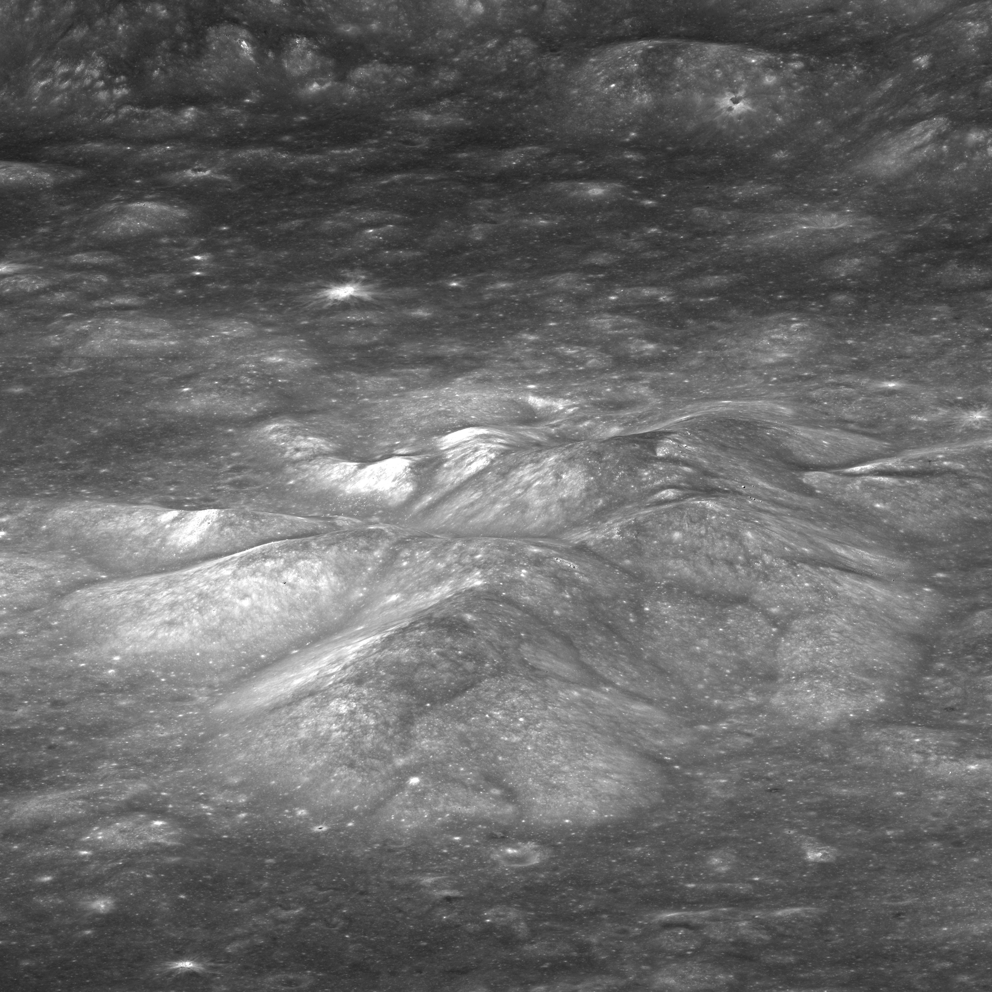
The central peak of Bullialdus crater (Credit: NASA/GSFC/Arizona State University)
Scientists have detected magmatic water — water that originates from deep within the Moon’s interior — on the surface of the Moon. These findings represent the first such remote detection of this type of lunar water, and were arrived at using data from NASA’s Moon Mineralogy Mapper (M3) carried aboard India’s Chandrayaan-1 lunar orbiter.
The discovery represents an exciting contribution to the rapidly changing understanding of lunar water according to Rachel Klima, a planetary geologist at the Johns Hopkins University Applied Physics Laboratory (APL) in Laurel, Md., and lead author of the paper, “Remote detection of magmatic water in Bullialdus Crater on the Moon” published in the August 25 issue of the journal Nature Geoscience.
Chandrayaan-1, India’s first mission to the Moon, entered lunar orbit on Nov. 8, 2008
“For many years, researchers believed that the rocks from the Moon were ‘bone dry’ and that any water detected in the Apollo samples had to be contamination from Earth,” said Klima, a member of the NASA Lunar Science Institute’s (NLSI) Scientific and Exploration Potential of the Lunar Poles team. “About five years ago, new laboratory techniques used to investigate lunar samples revealed that the interior of the Moon is not as dry as we previously thought. Around the same time, data from orbital spacecraft detected water on the lunar surface, which is thought to be a thin layer formed from solar wind hitting the lunar surface.”
“This surficial water unfortunately did not give us any information about the magmatic water that exists deeper within the lunar crust and mantle, but we were able to identify the rock types in and around Bullialdus crater,” said co-author Justin Hagerty, of the U.S. Geological Survey. “Such studies can help us understand how the surficial water originated and where it might exist in the lunar mantle.”
LRO image of the 60-km Bullialdus crater (NASA/GSFC/Arizona State University)
M3 (pronounced “M-cube”) fully imaged the large impact crater Bullialdus in 2009. “It’s within 25 degrees latitude of the equator and so not in a favorable location for the solar wind to produce significant surface water,” Klima explained. “The rocks in the central peak of the crater are of a type called norite that usually crystallizes when magma ascends but gets trapped underground instead of erupting at the surface as lava. Bullialdus crater is not the only location where this rock type is found, but the exposure of these rocks combined with a generally low regional water abundance enabled us to quantify the amount of internal water in these rocks.”
After examining the M3 data, Klima and her colleagues found that the crater has significantly more hydroxyl — a molecule consisting of one oxygen atom and one hydrogen atom — compared to its surroundings. “The hydroxyl absorption features were consistent with hydroxyl bound to magmatic minerals that were excavated from depth by the impact that formed Bullialdus crater,” Klima writes.
The internal magmatic water provides information about the Moon’s volcanic processes and internal composition, Klima said. “Understanding this internal composition helps us address questions about how the Moon formed, and how magmatic processes changed as it cooled. There have been some measurements of internal water in lunar samples, but until now this form of native lunar water has not been detected from orbit.”
“This impressive research confirms earlier lab analyses of Apollo samples, and will help broaden our understanding of how this water originated and where it might exist in the lunar mantle.”
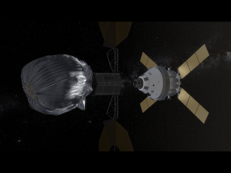
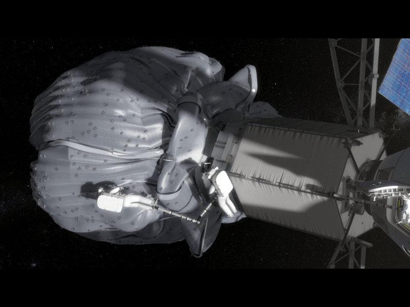
This concept image shows an astronaut retrieving a sample from the captured asteroid. Credit: NASA.
NASA has released some new photos and video animations outlining the concept of how their planned asteroid capture mission will work. The plan is to find, capture, redirect a near-Earth asteroid to a stable point near the Moon in order to explore and study it. As we’ve said previously, it’s still unclear if NASA will receive Congressional funding or authorization to do an asteroid retrieval mission, but the agency is moving ahead with its planning work for now.
NASA recently did a mission formulation review to look at some internal studies on the mission, as well as taking a look at over 400 ideas the space community submitted concerning the mission.
The new images show crew operations including the Orion spacecraft’s trip to and rendezvous with the relocated asteroid, as well as astronauts maneuvering through a spacewalk to collect samples from the asteroid.
You can watch the video and see more images below.
This conceptual image shows NASA’s Orion spacecraft approaching the robotic asteroid capture vehicle. The trip from Earth to the captured asteroid will take Orion and its two-person crew an estimated nine days. Credit: NASAIn this conceptual image, the two-person crew uses a translation boom to travel from the Orion spacecraft to the captured asteroid during a spacewalk. Credit: NASA.Artist’s Concept of a Solar Electric Propulsion System. Credit: Analytical Mechanics Associates
NASA is also looking at new technologies like a Solar Electric Propulsion System is an essential part of future missions into deep space with larger payloads. The use of advanced SEP offers more mission flexibility, NASA said.
If you’d like to get involved or add your input, NASA will host a technical workshop at the Lunar and Planetary Institute in Houston from Sept. 30 to Oct. 2 to discuss potential ideas. Virtual participation will be available to the public, and when the details of how to participate become available, Universe Today will post an update.
LADEE Minotaur V Launch - Maximum Elevation Map This map shows the maximum elevation (degrees above the horizon) that the Minotaur V rocket will reach during the Sep. 6, 2013 launch depending on your location along the US east coast. Credit: Orbital Sciences
LADEE Minotaur V Launch – Maximum Elevation Map
The LADEE nighttime launch will be visible to millions of spectators across a wide area of the Eastern US -weather permitting. This map shows the maximum elevation (degrees above the horizon) that the Minotaur V rocket will reach during the Sep. 6, 2013 launch depending on your location along the US east coast. Credit: Orbital Sciences [/caption]
A spectacular nighttime blastoff blazing a historic trail to the Moon is set to soar in two weeks time when NASA’s LADEE spacecraft lifts off from the Eastern Shore of Virginia at NASA’sWallops Flight Facility on Wallops Island – from America’s newest spaceport.
NASA’s Lunar Atmosphere and Dust Environment Explorer (LADEE) Observatory will thunder to space at 11:27 p.m. Friday, Sept. 6, from the commercial Mid-Atlantic Regional Spaceport (MARS) launch complex 0B at NASA’s Wallops Island facility atop the maiden flight of the new, solid fueled Minotaur V rocket developed by Orbital Sciences Corp.
LADEE’s late night launch will be absolutely spectacular and visible to tens of millions of spectators up and down the US East coast and interior areas stretching into the Midwest- weather permitting.
“I love this mission,” said John Grunsfeld, NASA Associate Administrator for Science at NASA Headquarters, at a media briefing today, Aug. 22.
LADEE’s Ticket to the Moon – 5th Stage of new Minotaur V rocket
Close-up view of STAR 37 5th stage solid fuel motor for inaugural Minotaur V rocket launch at NASA Wallops rocket facility will propel LADEE into its lunar transfer orbit. LADEE will be mounted on top and surrounded by the payload fairing attached at bottom ring. Credit: Ken Kremer/kenkremer.com
“With NASA’s prior LRO and GRAIL spacecraft we studied the Moon’s surface and interior. Now with LADEE we study the atmosphere and dust,” said John Grunsfeld.
The purpose of LADEE is to collect data that will inform scientists in unprecedented detail about the ultra thin lunar atmosphere, environmental influences on lunar dust and conditions near the surface. In turn this will lead to a better understanding of other planetary bodies in our solar system and beyond.
The small car sized LADEE lunar orbiter mission will be historic in many ways. It’s the first probe of any kind ever launched to beyond Earth orbit from NASA Wallops, as well as being the first planetary science mission from Wallops.
It also marks the first launch of a five stage rocket and the first launch of a decommissioned Peacekeeper missile from Wallops.
The first three stages of the Minotaur V are based on the nuclear armed Peacekeeper ICBM intercontinental ballistic missile built during the Cold War – now retired and refurbished by Orbital for peaceful uses. Its literally beating sword into ploughshares.
The 5th stage is a new addition and what makes this Minotaur a new rocket class. The added thrust is precisely what enables shooting for the Moon.
Recently, I had an exclusive tour and photoshoot up close and personal with the upper stages of LADEE’s Minotaur V rocket at Wallops prior to integration at the commercial launch pad – 0B – and will be reporting on that here and in upcoming stories.
4th and 5th stages of the inaugural Minotaur V rocket launch that will propel NASA’s LADEE lunar spacecraft to the Moon on Sep. 6, 2013 from NASA Wallops Island in Virginia. Credit: Ken Kremer/kenkremer.com
“LADEE is equipped with three science instruments to study the atmosphere and dust and a lunar laser technology demonstration,” said Joan Salute, LADEE program executive, NASA Headquarters.
These include an ultraviolet and visible light spectrometer that will gather detailed information about the composition of the tenuous lunar atmosphere; a neutral mass spectrometer to measure variations in the lunar atmosphere over time; a laser dust experiment that will collect and analyze dust particle samples; and a laser communications experiment that will test the use of lasers in place of radio waves for high speed dad communications with Earth.
“The lunar atmosphere is so thin that the molecules never collide,’ said Sarah Noble, LADEE program scientist, NASA Headquarters.
“It’s a ‘Surface Boundary Exosphere’ which is actually the most common type of atmosphere in our Solar System.”
Scientists also hope to solve a mystery dating back nearly five decades to the Apollo moon landing era, by determining if electrically charged lunar dust is responsible for the pre-sunrise horizon glow seen by the Apollo astronauts and also by the unmanned Surveyor 7 lander, according to Noble.
“This is the first NASA mission with a dedicated laser communications experiment,” said Don Cornwell, mission manager for the Lunar Laser Communications Demonstration, NASA’s Goddard Space Flight Center, Greenbelt, Md.
I asked when we could see laser communications implemented on future NASA spacecraft?
“A new laser communications system could possibly be used on the 2020 Mars rover from the surface of Mars,” Grunsfeld told Universe Today.
The couch sized 844 pound (383 kg) robotic explorer was assembled at NASA’s Ames Research Center, Moffett Field, Calif., and is a cooperative project with NASA Goddard Spaceflight Center in Maryland.
The spacecraft is a first of its kind vehicle built from a NASA Ames-developed Modular Common Spacecraft Bus architecture that can be applied to other missions. The mission cost is approximately $280 million.
The Minotaur V will boost LADEE into a highly elliptical orbit. Then over the next 23 days, as LADEE orbits Earth 3.5 times, the Moon’s gravitational field will increase the perigee of its orbit. The spacecraft will fire its on-board braking thrusters to achieve lunar orbit.
NASA Ames LADEE Mission – Lunar Orbital Insertion Animation
Video caption: This animation is a representation of lunar orbital insertion for LADEE, which is the path the spacecraft follows when it is captured by the Moon’s gravity and enters lunar orbit. Credit: NASA Ames/Dana Berry. Note: Animation is silent with no audio/music track included.
The mission will fly in a very low science orbit of about 50 kilometers altitude above the moon. The science mission duration is approximately 100 days.
“It’s limited by the amount of onboard fuel required to maintain orbit,” Doug Voss, launch manager, Wallops, told Universe Today.
“I’m excited about the night launch because people up and down the Atlantic seacoast will be able to see it,” Jim Green, Planetary Science Division Director at NASA HQ, told me.
And don’t forget that NASA has a 2nd really big launch from Wallops slated for Sep. 17 – with blastoff of the Orbital Sciences Antares rocket and Cygnus cargo carrier on their historic 1st mission to the International Space Station (ISS).
I’ll be on site at Wallops for both historic launches on Sep. 6 and 17 – reporting for Universe Today.
…………….
Learn more about LADEE, Cygnus, Antares, MAVEN, Orion, Mars rovers and more at Ken’s upcoming presentations
Sep 5/6/16/17: “LADEE Lunar & Antares/Cygnus ISS Rocket Launches from Virginia”; Rodeway Inn, Chincoteague, VA, 8 PM
Oct 3: “Curiosity, MAVEN and the Search for Life on Mars – (3-D)”, STAR Astronomy Club, Brookdale Community College & Monmouth Museum, Lincroft, NJ, 8 PM
Oct 9: “LADEE Lunar & Antares/Cygnus ISS Rocket Launches from Virginia”; Princeton University, Amateur Astronomers Assoc of Princeton (AAAP), Princeton, NJ, 8 PM
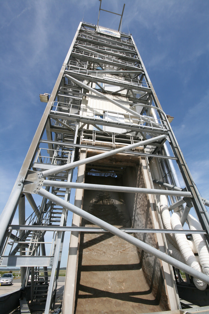
Looking up the Flame Trench of the LADEE Minotaur V Launch Pad 0B at NASA Wallops Flight Facility in Virginia. Credit: Ken Kremer/kenkremer.com
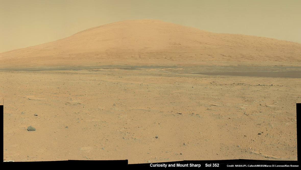
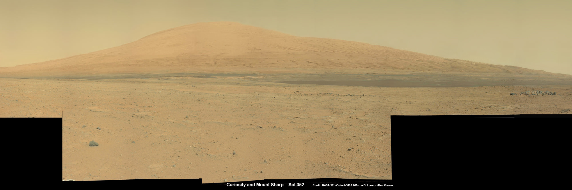
Curiosity Spies Mount Sharp - her primary destination. Curiosity will ascend mysterious Mount Sharp and investigate the sedimentary layers searching for clues to the history and habitability o the Red Planet of billions of years. This mosaic was assembled from Mastcam camera images taken on Sol 352 (Aug 2, 2013. Credit: NASA/JPL-Caltech/MSSS/ Marco Di Lorenzo/Ken Kremer
Curiosity Spies Mount Sharp – her primary destination. Curiosity will ascend mysterious Mount Sharp and investigate the sedimentary layers searching for clues to the history and habitability of the Red Planet over billions of years. But first she must safely trespass through the treacherous dark dunes fields. This mosaic was assembled from over 2 dozen Mastcam camera images taken on Sol 352 (Aug 2, 2013). Credit: NASA/JPL-Caltech/MSSS/ Marco Di Lorenzo/Ken Kremer
See the full mosaic below [/caption]
It’s never a dull moment for NASA’s Curiosity rover at T Plus 1 Year since touchdown on the Red Planet and T Minus 1 year to arriving at her primary target, the huge mountain overwhelming the center of the landing site inside Gale Crater.
Curiosity is literally and figuratively zooming in on stunningly beautiful and mysterious Mount Sharp (see our new mosaics above/below), her ultimate destination, while conducting ‘Science on the Go’ with her duo of chemistry labs – SAM and CheMin – and 8 other science instruments as she passes the 2 kilometer driving milestone today; Aug 20 !
“We are holding samples for drops to ChemMin and SAM when the science team is ready for it,” Jim Erickson, Curiosity Project Manager of NASA’s Jet Propulsion Laboratory (JPL), told Universe Today in an exclusive interview.
“Curiosity has landed in an ancient river or lake bed on Mars,” Jim Green, Director of NASA’s Planetary Science Division, told Universe Today.
So, those samples were altered by liquid Martian water – a prerequisite for life.
Curiosity Spies Mount Sharp – her primary destination. Curiosity will ascend mysterious Mount Sharp and investigate the sedimentary layers searching for clues to the history and habitability of the Red Planet over billions of years. But first she must safely trespass through the treacherous dark dunes fields. This mosaic was assembled from over 3 dozen Mastcam camera images taken on Sol 352 (Aug 2, 2013.
Credit: NASA/JPL-Caltech/MSSS/ Marco Di Lorenzo/Ken Kremer-kenkremer.com
In fact the car sized rover has saved samples from both the ‘John Klein’ and ‘Cumberland’ drill sites collected previously in the ‘Yellowknife Bay’ area for analysis by the miniaturized labs in the rovers belly -when the time is right.
“Curiosity has stored a Cumberland sample and still has a John Klein sample on board for future use,” Erickson explained.
And that time has now arrived!
“We have put a sample from the Cumberland drill hole into SAM for more isotopic measurements,” reported science team member John Bridges in a blog update on Sol 363, Aug. 14, 2013.
“The sample had been cached within the robotic arm’s turret.”
Curiosity is multitasking – conducting increasingly frequent traverses across the relatively smooth floor of Gale Crater while running research experiments for her science handlers back here on Earth.
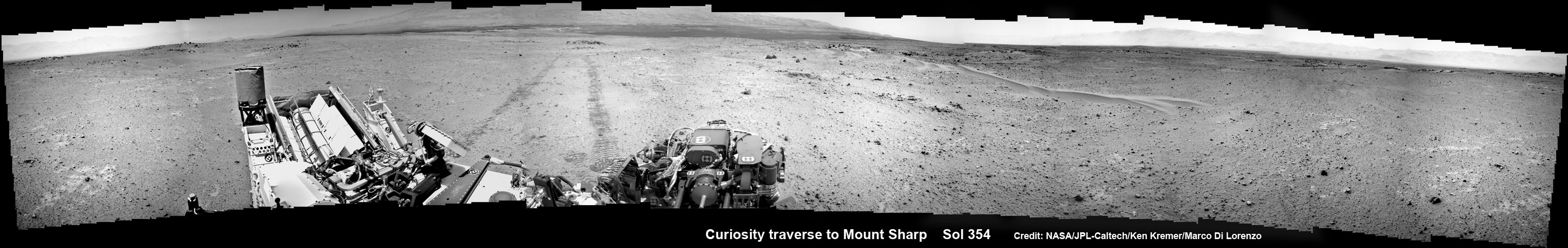
NASA’s Curiosity rover make tracks to Mount Sharp (at left) across the floor of Gale Crater. The rover paused to image the windblown ripple at right, below the hazy crater rim. The wheel tracks are about eight feet apart. This panoramic mosaic was assembled from a dozen navcam camera images taken on Sol 354 (Aug 4, 2013). Credit: NASA/JPL-Caltech/Ken Kremer/Marco Di Lorenzo
She’s captured stunning new views of Mount Sharp – rising 5 km (3 miles) high into the sky – and movies of Mars tiny pair of transiting moons while ingesting new portions of the drilled rock samples acquired earlier this year.
Here’s our video compilation of Phobos and Deimos transiting on Aug 1, 2013
Video caption: Transit of Phobos in front of Deimos, taken by MSL right MastCam imager on Sol 351 around 3:12 AM local time (Aug 1, 2013, 8:42 UTC); 16 original frames + 14 interpolated (5x speed-up). Credit: NASA/JPL-Caltech/MSSS/ Marco Di Lorenzo/Ken Kremer
The sample analysis is still in progress.
“The SAM data have not all been received yet,” wrote science team member Ken Herkenhoff in a blog update.
Earlier analysis of sample portions from both ‘John Klein’ and ‘Cumberland’ revealed that the Yellowknife Bay area on Mars possesses the key mineral ingredients proving that Red Planet was once habitable and could have sustained simple microbial life forms.
The scientists are seeking further evidence and have yet to detect organic molecules – which are the building blocks of life as we know it.
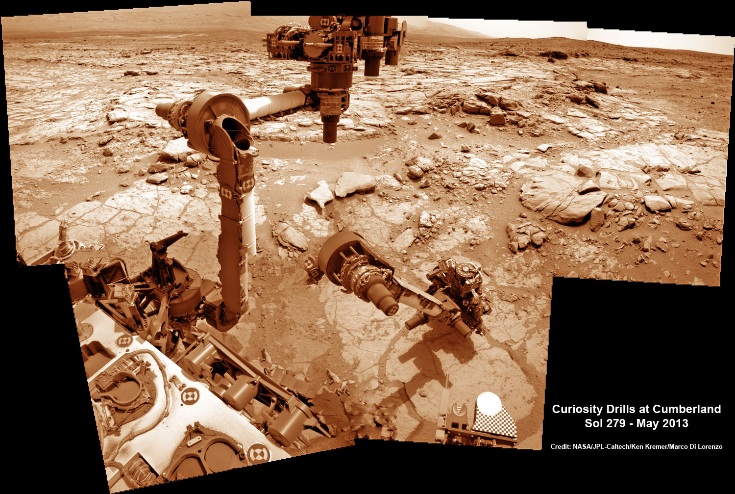
This time lapse mosaic shows Curiosity maneuvering her robotic arm to drill into her 2nd martian rock target named “Cumberland” to collect powdery Martian material on May 19, 2013 (Sol 279) for analysis by her onboard chemistry labs; SAM & Chemin- see 3 inlet ports lower left. The photomosaic was stitched from raw images captured by the navcam cameras on May 14 & May 19 (Sols 274 & 279). Credit: NASA/JPL-Caltech/Ken Kremer/Marco Di Lorenzo
Yellowknife Bay resembles a dried out river bed where liquid water once flowed eons ago when the Red Planet was far warmer and wetter than today.
As the 1 ton robot ascends Mount Sharp, she will examine sedimentary layers layed down on ancient Mars over hundreds of millions and perhaps billions of years of past history and habitability.
And just as the rover was celebrating 1 year on Mars on Aug 5/6, she found an intriguing sand dune on Sol 354. See our mosaic
“The rover paused to take images of its tracks after crossing a windblown ripple,” Herkenhoff reported.
As the six wheeled rover approaches Mount Sharp over the next year, she will eventually encounter increasing treacherous dunes that she must cross before beginning her mountain climbing foray.
As of today, Sol 369 (Aug. 20) Curiosity has broken through the 2 kilometer driving mark with a new 70 meter drive, snapped over 75,000 images and fired over 75,000 laser shots.
Mount Sharp is about 8 kilometers (5 miles) distant as the Martian crow flies.
How long will the journey to Mount Sharp require?
“Perhaps about a year,” Erickson told me. “We are trying to make that significantly faster by bringing autonav [autonomous navigation software] online.”
“That will help. But how much it helps really depends on the terrain.”
So far so good.
Meanwhile NASA’s next Mars orbiter called MAVEN (for Mars Atmosphere and Volatile Evolution), recently arrived at the Kennedy Space Center after a cross country flight.
Kennedy technicians are completing assembly and check out preparations for MAVEN’s blastoff to the Red Planet on Nov. 18 from Florida atop an Atlas V rocket similar to the one that launched Curiosity nearly 2 years ago.
And I’ll be at Kennedy to report up close on MAVEN’s launch.
Wide-field Infrared Survey Explorer (WISE) spacecraft. Credit: NASA.
A hibernating spacecraft has been called back into service. The WISE (Wide-field Infrared Survey Explorer”) spacecraft that has been sleeping in a polar orbit around Earth for two years will be turned back on next month to hunt for more potentially hazardous asteroids, and perhaps search for an asteroid that NASA could capture and explore in the future.
“The WISE mission achieved its mission’s goals and as NEOWISE extended the science even further in its survey of asteroids. NASA is now extending that record of success, which will enhance our ability to find potentially hazardous asteroids, and support the new asteroid initiative,” said John Grunsfeld, NASA’s associate administrator for science. “Reactivating WISE is an excellent example of how we are leveraging existing capabilities across the agency to achieve our goal.”
WISE originally was launched in December 2009 and scanned the entire celestial sky in infrared light about 1.5 times, searching for the coolest stars, the universe’s most luminous galaxies and some of the darkest near-Earth asteroids and comets. It captured more than 2.7 million images of objects in space, ranging from faraway galaxies to asteroids and comets close to Earth.
However, in early October 2010, after completing its prime science mission, the spacecraft ran out of the frozen coolant that keeps its instrumentation cold. But two of its four infrared cameras remained operational, which were still optimal for asteroid hunting, so NASA extended the NEOWISE portion of the WISE mission by four months, with the primary purpose of hunting for more asteroids and comets, and to finish one complete scan of the main asteroid belt.
The NEOWISE mission completed a full sweep of the main asteroid belt, and during 2010, NEOWISE observed about 158,000 rocky bodies out of approximately 600,000 known objects. Discoveries included 21 comets, more than 34,000 asteroids in the main belt between Mars and Jupiter, and 135 near-Earth objects.
“The data collected by NEOWISE two years ago have proven to be a gold mine for the discovery and characterization of the NEO population,” said Lindley Johnson, NASA’s NEOWISE program executive in Washington. “It is important that we accumulate as much of this type of data as possible while the WISE spacecraft remains a viable asset.”
Now WISE will again search for asteroids with a new extra-extended three year mission to search for more PHAs as well as suitable asteroids for future human exploration missions.
Concept of NASA spacecraft with Asteroid capture mechanism deployed to redirect a small space rock to a stable lunar orbit for later study by astronauts aboard Orion crew capsule. Credit: NASA.
NASA said they anticipate WISE will use its 16-inch (40-centimeter) telescope and infrared cameras to discover about 150 previously unknown NEOs and characterize the size, albedo and thermal properties of about 2,000 others — including some of which could be candidates for the agency’s recently announced asteroid initiative.
“The team is ready and after a quick checkout, we’re going to hit the ground running,” said Amy Mainzer, NEOWISE principal investigator at NASA’s Jet Propulsion Laboratory in Pasadena, Calif. “NEOWISE not only gives us a better understanding of the asteroids and comets we study directly, but it will help us refine our concepts and mission operation plans for future, space-based near-Earth object cataloging missions.”
Polar mesospheric clouds shine over a midnight sunrise above Alaska on August 4, 2013 (NASA)
Looking for a new desktop background? This might do nicely: a photo of noctilucent “night-shining” clouds seen above a midnight Sun over Alaska, taken from the ISS as it passed over the Aleutian Islands just after midnight local time on Sunday, August 4.
When this photo was taken Space Station was at the “top of the orbit” — 51.6 ºN, the northernmost latitude that it reaches during its travels around the planet.
According to the NASA Earth Observatory site, “some astronauts say these wispy, iridescent clouds are the most beautiful phenomena they see from orbit.” So just what are they? Read on…
Found about 83 km (51 miles) up, noctilucent clouds (also called polar mesospheric clouds, or PMCs) are the highest cloud formations in Earth’s atmosphere. They form when there is just enough water vapor present to freeze into ice crystals. The icy clouds are illuminated by the Sun when it’s just below the horizon, after darkness has fallen or just before sunrise, giving them their eponymous property.
NLCs seen in the southern hemisphere in Jan. 2010 (NASA)
Noctilucent clouds have also been associated with rocket launches, space shuttle re-entries, and meteoroids, due to the added injection of water vapor and upper-atmospheric disturbances associated with each. Also, for some reason this year the clouds appeared a week early.
Some data suggest that these clouds are becoming brighter and appearing at lower latitudes, perhaps as an effect of global warming putting more greenhouse gases like methane into the atmosphere.
“When methane makes its way into the upper atmosphere, it is oxidized by a complex series of reactions to form water vapor,” said James Russell, the principal investigator of NASA’s Aeronomy of Ice in the Mesosphere (AIM) project and a professor at Hampton University. “This extra water vapor is then available to grow ice crystals for NLCs.”
A comparison of noctilucent cloud formation from 2012 and 2013 has been compiled using data from the AIM spacecraft. You can see the sequence here.
And for an incredible motion sequence of noctilucent clouds — taken from down on the ground — check out the time-lapse video below by Maciej Winiarczyk, coincidentally made at around the same time as the ISS photo above:
(The video was featured as the Astronomy Picture of the Day (APOD) for August 19, 2013.)
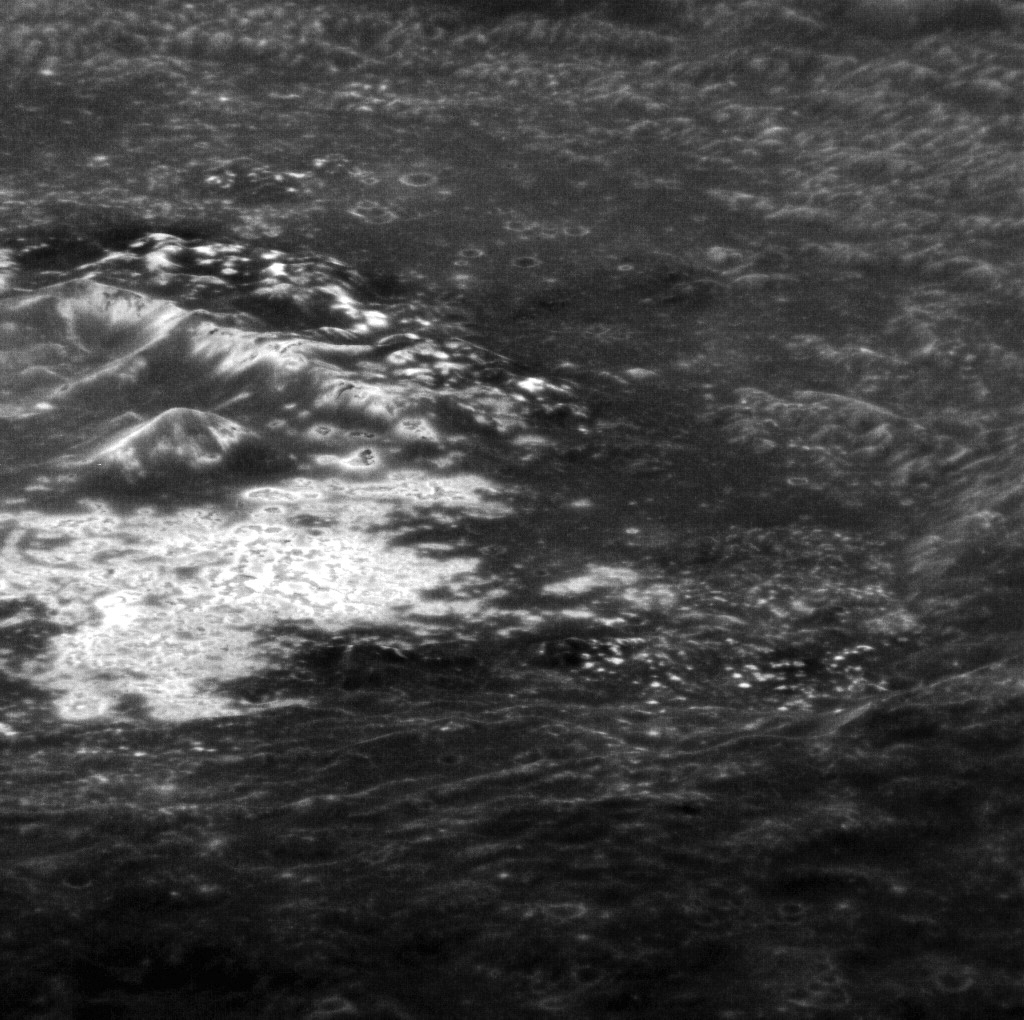
Hi-res targeted MESSENGER image of the interior of Tyagaraja crater (north is to the right).
Here’s a rather interesting view from orbit around the innermost planet: Mercury’s Tyagaraja crater, the interior of which is seen here in an oblique-angled image acquired by the MESSENGER spacecraft on November 12, 2011 (and released August 16, 2013.)
This view looks west across the northern portion of the 97-kilometer (60-mile) -wide crater, and shows some of its large central peaks, terraced walls, and bright erosion features called hollows that are spread across a wide swath of its interior.
First seen by MESSENGER in 2011, hollows are thought to indicate an erosion process unique to Mercury because of its composition and close proximity to the Sun. The lack of craters within hollows seems to indicate that they are relatively young features… in fact, they may be part of a process that continues today.
This image was acquired as a high-resolution targeted observation. Targeted observations are images of a small area on Mercury’s surface at resolutions much higher than the 200-meter/pixel morphology base map.
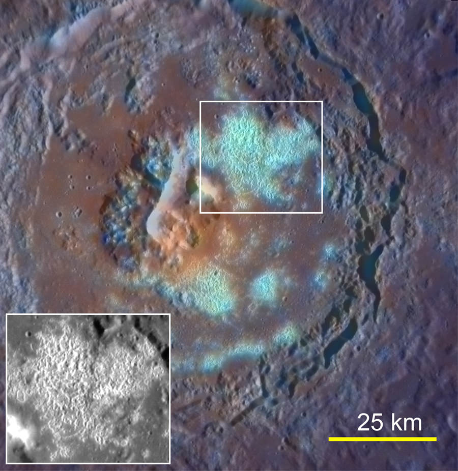
Enhanced-color image of Tyagaraja crater acquired on Sept. 29, 2011. Its large hollow field is highlighted.
Tyagaraja is named after Kakarla Tyagabrahmam, an 18th-century composer of classical Indian Carnatic music.
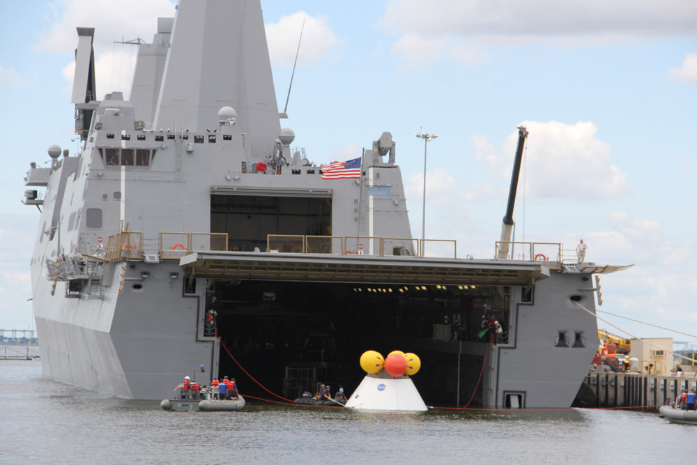
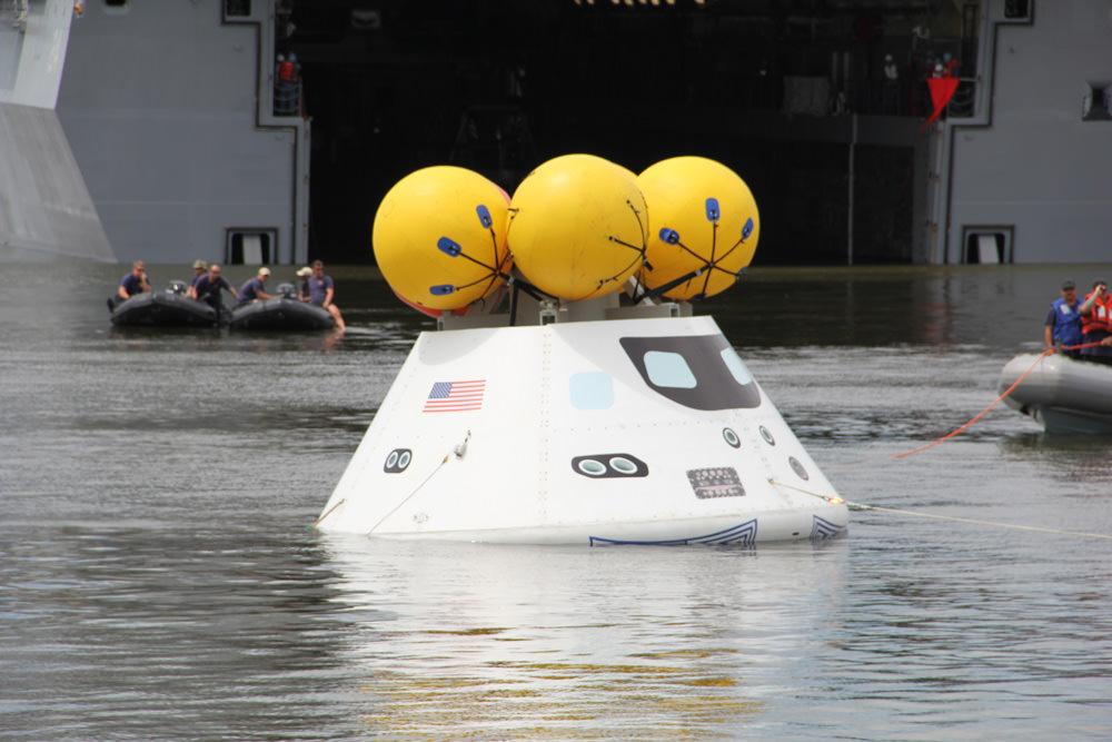
During the stationary recovery test of Orion at Norfolk Naval Base on Aug. 15, US Navy divers attached tow lines and led the test capsule to a flooded well deck on the USS Arlington. Credit: Ken Kremer/kenkremer.com
During the stationary recovery test of Orion at Norfolk Naval Base on Aug. 15, 2013, US Navy divers attached tow lines and led the test capsule to a flooded well deck on the USS Arlington. Credit: Ken Kremer/kenkremer.com. Story updated with additional test Video and images[/caption]
NAVAL STATION NORFOLK,VA – When American astronauts again venture into deep space sometime in the next decade, their return trip to Mother Earth will end with the splashdown of their Orion capsule in the Pacific Ocean – much like the Apollo lunar landing crews of four decades ago.
But before that can happen, Orion must first pass through a myriad of milestones to insure the safe return of our human crews.
A NASA and U.S. Navy test successfully demonstrated the water recovery of the Orion crew module today (Aug. 15) at Naval Station Norfolk in Virginia – and Universe Today witnessed the entire operation.
“Today’s test was terrific,” Scott Wilson, NASA’s Orion Manager of Production Operations, told Universe Today in a post test interview at Naval Station Norfolk.
“We got all the data we needed and the test was very successful. This was exactly what we wanted to do and we don’t like surprises.”
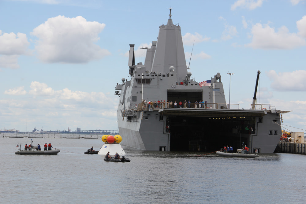
US Navy divers on four boats attached tow lines and to the Orion test capsule and guide it to the well deck on the USS Arlington during Aug. 15 recovery test at Norfolk Naval Base, VA.
Credit: Ken Kremer/kenkremer.com
Today’s ‘Orion Stationary Recovery Test’ was conducted to support the upcoming first flight of Orion on the EFT-1 mission due to blastoff in September 2014 from Cape Canaveral, Florida.
“We completed all of our primary and secondary test objectives,” Wilson stated.
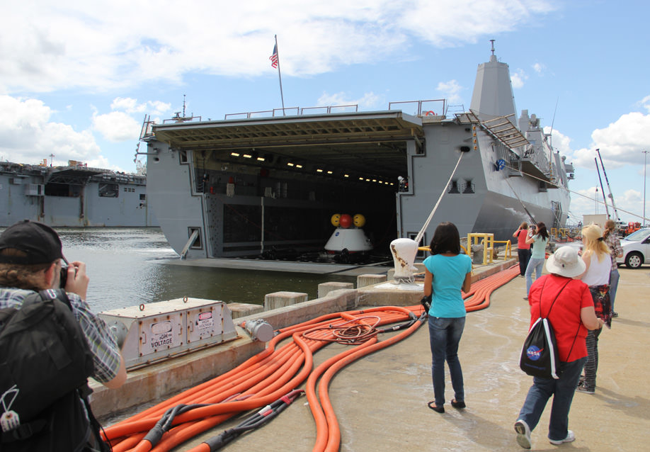
Teams of US Navy divers in a flotilla of amphibious boats launched from the USS Arlington approached a test version of the Orion capsule known as the boilerplate test article (BTA). The Arlington was docked against its pier during the test in a benign, controlled environment.
Dive teams attach tow lines to Orion test capsule during Aug. 15 recovery test at Norfolk Naval Base, VA. Credit: Ken Kremer/kenkremer.com
Divers attached several tow lines to the capsule, in a coordinated operation with the Arlington, and led the capsule into the ship’s flooded well deck.
The Orion capsule was carefully towed inside the well deck and positioned over the recovery cradle. The sea water was drained and the capsule was attached to the recovery cradle.
Dive teams haul Orion onto the well deck of the USS Arlington during Aug. 15 recovery test at Norfolk Naval Base, VA. Credit: Ken Kremer/kenkremer.com
“During the test there is constant radio communications between the ship and the divers teams in the boats.”
“The operation within the well deck areas are also being controlled as well as the rope and winch handlers on the boat,” Wilson told me.
At the conclusion of the test, myself and the NASA social media participants boarded the USS Arlington and toured the Orion capsule for a thrilling up close look.
Myself and NASA social media participants observed Orion after hauled aboard the well deck and boarded the USS Arlington recovery ship. Credit: Ken Kremer/kenkremer.com
“Today marks a significant milestone in the Navy’s partnership with NASA and the Orion Human Space Flight Program,” said Navy Commander Brett Moyes, Future Plans Branch chief, U.S. Fleet in a statement.
“The Navy is excited to support NASA’s continuing mission of space exploration. Our unique capabilities make us an ideal partner for NASA in the recovery of astronauts in the 21st century — just as we did nearly a half century ago in support of America’s quest to put a man on the moon.”
The ocean recovery of Orion will be far different from the Apollo era where the crew’s were first hoisted out of the floating capsule and the capsule then hoisted on deck of a US Navy aircraft carrier.
The next Orion water recovery test will be conducted in the open waters of the Pacific Ocean in January 2014.
Inside up close look at the Orion attached to the recovery cradle in the drained well deck of the USS Arlington recovery ship. Credit: Ken Kremer/kenkremer.com
NASA’s Langley Research Center in nearby Hampton, VA is conducting an extensive drop test program in support of the Orion project.
“The Orion capsule tested today has the same mold line and dimensions as the Orion EFT-1 capsule.”
“The Orion hardware and the Delta IV Heavy booster for the EFT-1 launch are on target for launch in 2014,” Wilson told me.
Watch this NASA Video of the Orion test:
During the unmanned Orion EFT-1 mission, the capsule will fly on a two orbit test flight to an altitude of 3,600 miles above Earth’s surface, farther than any human spacecraft has gone in 40 years.
The EFT-1 mission will provide engineers with critical data about Orion’s heat shield, flight systems and capabilities to validate designs of the spacecraft before it begins carrying humans to new destinations in the solar system, including an asteroid and Mars.
It will return to Earth at a speed of approximately 20,000 mph for a splashdown in the Pacific Ocean.
Right now its T Minus 1 Year and counting to liftoff of Orion EFT-1.
…………….
Learn more about Orion, Cygnus, Antares, LADEE, MAVEN, Mars rovers and more at Ken’s upcoming presentations
Sep 5/6/16/17: LADEE Lunar & Antares/Cygnus ISS Rocket Launches from Virginia”; Rodeway Inn, Chincoteague, VA, 8 PM
Oct 3: “Curiosity, MAVEN and the Search for Life on Mars – (3-D)”, STAR Astronomy Club, Brookdale Community College & Monmouth Museum, Lincroft, NJ, 8 PM
Social media and media including Ken observe the Aug. 15 Orion water recovery test from the pier at Naval Station Norfolk, VA. Credit: NASAScott Wilson, NASA’s Orion production manager and Ken Kremer, Universe Today discuss the Aug. 15 recovery test back dropped by Orion and the USS Arlington. Credit: Ken Kremer/kenkremer.com