Gorgeous Glenelg – ‘Promised Land’ Panorama on Mars

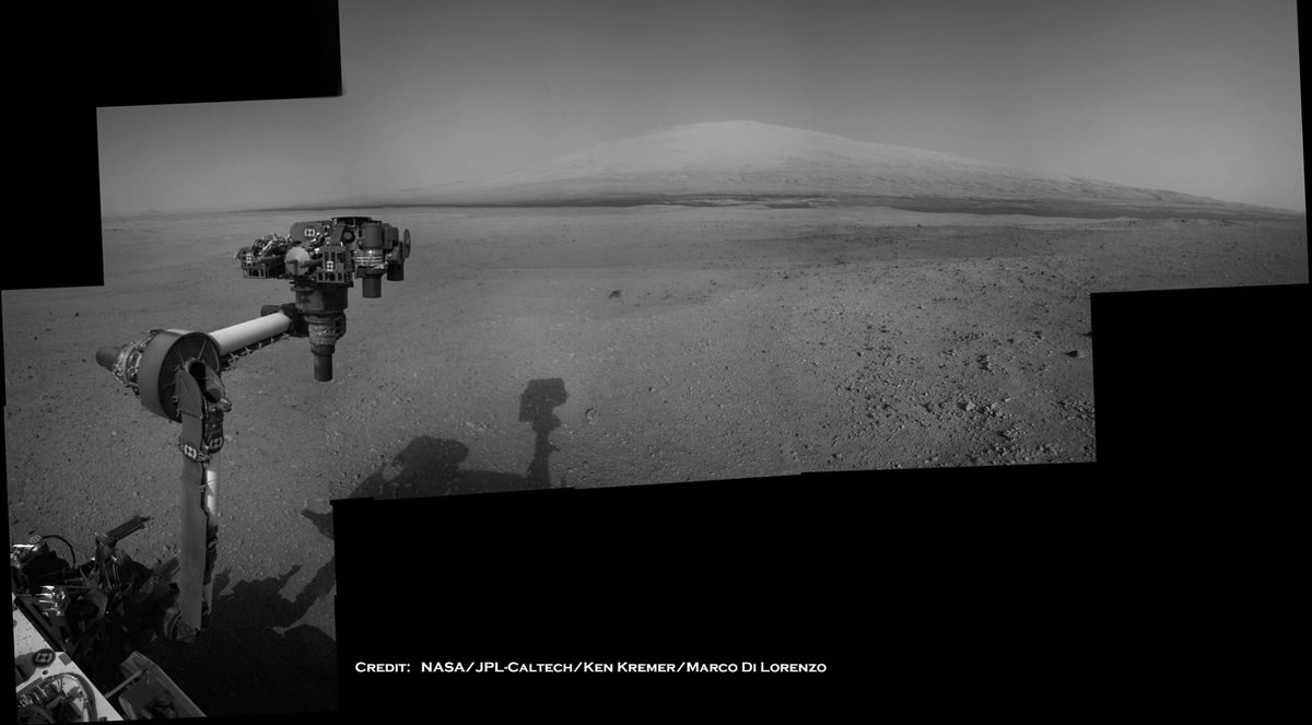
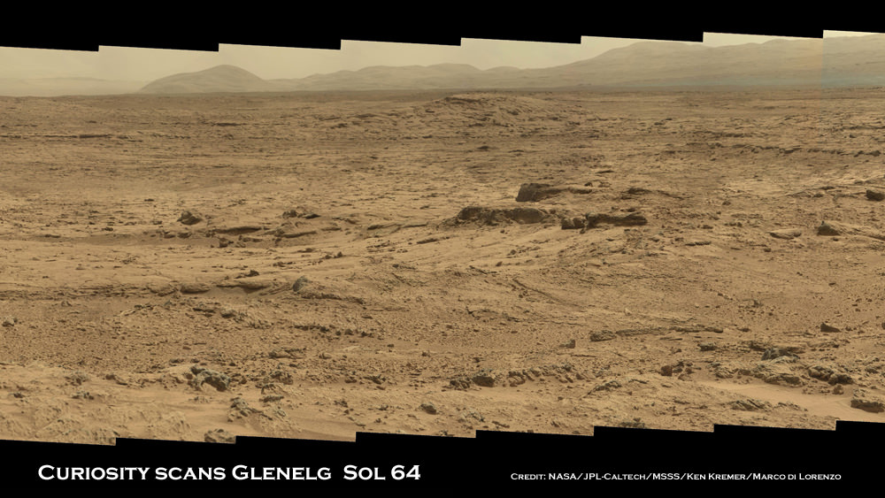
Image Caption: Panoramic mosaic shows gorgeous Glenelg snapped by Curiosity on Sol 64 (Oct. 10) with eroded crater rim and base of Mount Sharp in the distance. This is a cropped version of the full mosaic as assembled from 75 images acquired by the Mastcam 100 camera. See full mosaic below. Credit: NASA/JPL-Caltech/MSSS/Ken Kremer/Marco Di Lorenzo

NASA’s 1 ton mega rover Curiosity is simultaneously eating Martian dirt and busily snapping hundreds of critical high resolution color photos of her surroundings at the gorgeous locale of tasty terrain of outcrops the scientists call the ‘Promised Land’ – a place that will help unveil the watery mysteries of ancient Mars.

11 weeks into Curiosity’s 2 year primary mission she finds herself at a spot dubbed Glenelg – her first major science destination – and which lies at the natural junction of three types of geologically varied terrain.

See our detailed color panoramic mosaics of the road ahead inside Glenelg as the robot methodically scans around at the inviting mix of geologic features never before investigated by a robotic emissary from Earth.

Glenelg offers an unprecedented opportunity for a boon of discoveries to the rover science team long before she arrives at her ultimate destination – the 3.4 mile (5.5 km) high layered mountain named Mount Sharp.

Image Caption: Panoramic mosaic shows gorgeous Glenelg snapped by Curiosity from Rocknest windblown dune on Sol 64 (Oct. 10) with eroded crater rim and base of Mount Sharp in the distance. This mosaic as assembled from 75 images acquired by the high resolution Mastcam 100 camera on Sol 64. Click to enlarge. Credit: NASA/JPL-Caltech/MSSS/Ken Kremer/Marco Di Lorenzo

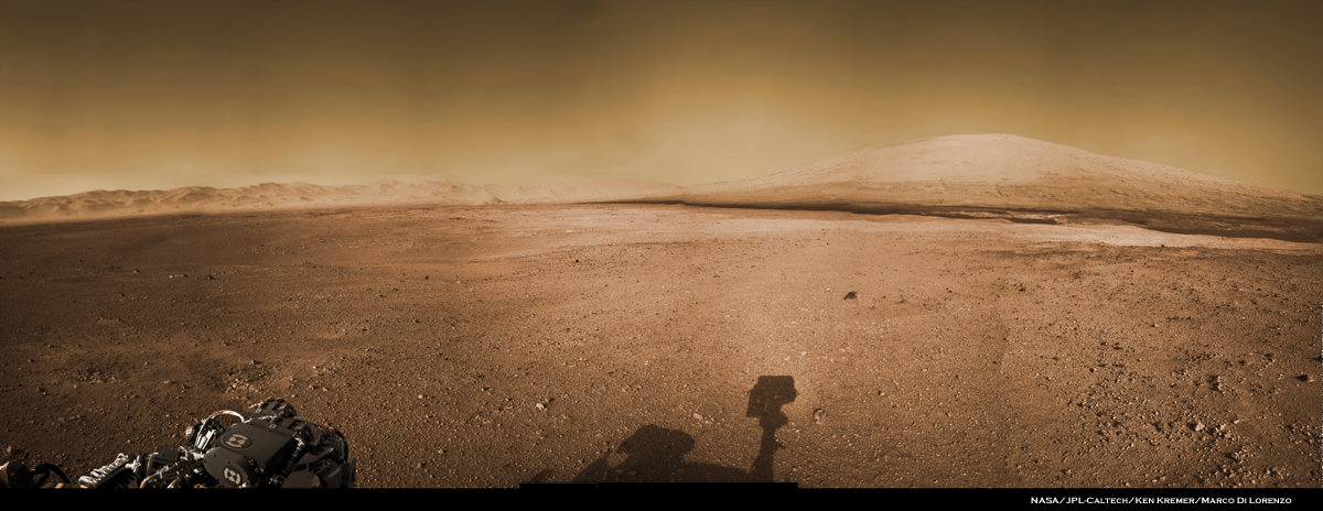
Image Caption: Panorama shows beautiful vista of distant eroded rim of Gale Crater and breathtaking foreground terrain. This mosaic was assembled from high resolution Mastcam 100 images taken by Curiosity on Sol 50 (Sep. 26). Credit: NASA/JPL-Caltech/MSSS/Ken Kremer/Marco Di Lorenzo

Curiosity Project Scientist John Grotzinger scientist explained to me that the team is using the Mastcam 100 imagery to come up with options for the upcoming driving and exploration plan to be carried out over at least the next few weeks.

“We are at Glenelg and consider ourselves to be in the ‘Promised Land’. We took the images in the direction we will be traveling,” said Curiosity Project Scientist John Grotzinger of the California Institute of Technology during a media teleconference on Oct. 18.

“We mostly see outcrops there and that’s the reason we took those prioritized images,” he said about the Mastcam 100 imagery from Sols 64 and 66.

“These images will help guide us and give the team options in terms of what I am calling ‘tours’. The team comes up with hypothesis based on the images about observations they would like to make and where they would like to drive.”.

“Then we will integrate the different observations to come up with a model we hope for how the Glenelg area was put together geologically. And then that will inform ultimately our selection for which rock to drill into for the first time,” explained Grotzinger.

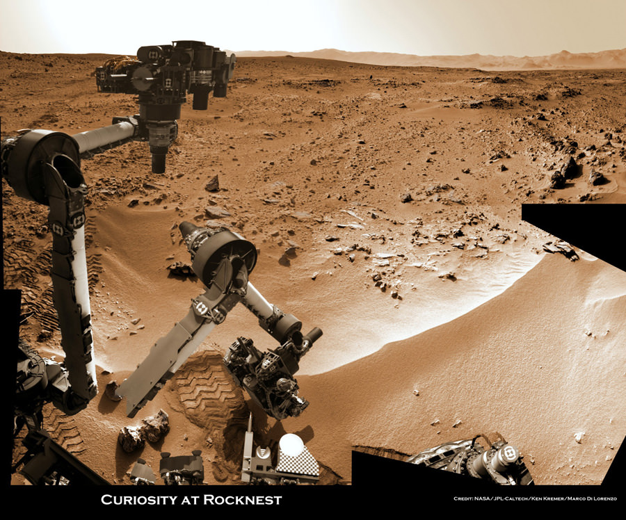
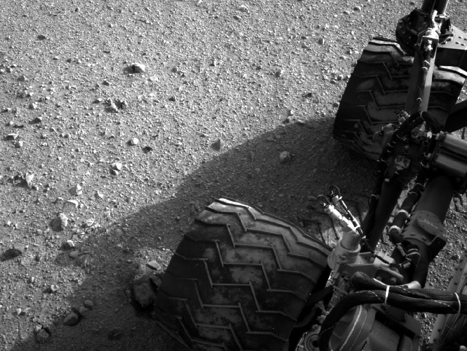
Image Caption: Curiosity scoops up Martian soil sample on Sol 66 (Oct 12. 2012). Navcam camera image mosaic shows the robotic arm at work during scooping operations. Curiosity later delivered the first soil sample to the circular CheMin sample inlet at the center on the rover deck. Tiny trenches measure about 1.8 inches (4.5 centimeters) wide. Credit: NASA/JPL-Caltech/Ken Kremer/Marco Di Lorenzo

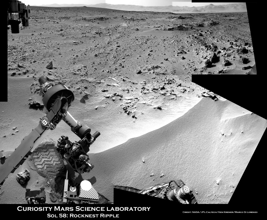
Image caption: Three bite marks left in the Martian ground by the scoop on the robotic arm of NASA’s Mars rover Curiosity are visible in this image taken by the rover’s right Navigation Camera during the mission’s 69th Martian day, or sol (Oct. 15, 2012). Credit: NASA/JPL-Caltech

Curiosity is currently parked at a windblown ripple named ‘Rocknest’. It afforded the perfect type of dusty martian material to first test out the scoop and clean the sample processing system twice before finally inhaling the first sample of Martian sand into the robots Chemistry and Mineralogy (CheMin) analytical instrument several sols ago to determine what minerals it contains.

Results from the Red Planet soil poured into the CheMin experiment located on the rover’s deck are expected in the coming week or so.

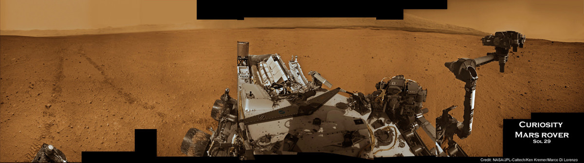
Tosol is Sol 75. Curiosity has taken nearly 20,000 pictures so far and driven a total distance of about 1,590 feet (484 meters).

Ken Kremer

See more of our Curiosity Mars mosaics by Ken Kremer & Marco Di Lorenzo at NBC News Cosmic log

…..
Nov. 16: Free Public Lecture by Ken Kremer about “Curiosity and the Search for Life in 3 D” and more at Union County College and Amateur Astronomers Inc in Cranford, NJ.

Mars rover Scooping in Search of Pristine material at Rocknest

Image caption: Time lapse context view of Curiosity maneuvering her robotic arm. Curiosity conducts a close- up examination of windblown ‘Rocknest’ ripple site and inspects sandy material at “bootlike” wheel scuff mark with the APXS (Alpha Particle X-Ray Spectrometer) and MAHLI (Mars Hand Lens Imager) instruments positioned on the rotatable turret at the arm’s terminus. Colorized mosaic was stitched together from Sol 57 & 58 Navcam raw images shows the arm in action just prior to 1st sample scooping here. Surrounding terrain and eroded rim of Gale Crater rim is visible on the horizon. Credit: NASA/JPL-Caltech/Ken Kremer/Marco Di Lorenzo

NASA’s Curiosity rover is actively searching for uncontaminated Martian soil after finding new flecks of “bright material” of unknown origin in the windblown sands at “Rocknest” ripple.

The team leading the Curiosity Mars Science Lab (MSL) mission decided to dump the second scoopful of dusty material collected last week on Sol 66 (Oct. 12). Instead they will search for pristine Martian sand to pour into the rover’s critical sample-processing mechanisms to use as a decontamination agent for cleansing the interior chambers and walls of Earthly residues.

Image Caption: Bright Particle of Martian Origin in Scoop Hole. This image contributed to an interpretation by NASA’s Mars rover Curiosity science team that some of the bright particles on the ground near the rover are native Martian material. Other light-toned material nearbyhas been assessed as small debris from the spacecraft. Curiosity’s Mars Hand Lens Imager (MAHLI) camera took this image on Sol 66 (Oct. 12, 2012) showing part of the hole or bite left in the ground when Curiosity collected its first scoop of Martian soil five sols earlier. A clod of soil near the top center of the image contains a light-toned particle. The observation that the particle is embedded in the clod led scientists to assess this particle as Martian material, not something from the spacecraft. This assessment prompted the mission to continue scooping in the area, despite observations of a few light-toned particles in the area being scooped. The image shows an area about 2 inches (5 centimeters) across. It is brightened to improve visibility in the shaded area. Credit: NASA/JPL-Caltech/MSSS

The science team is proceeding with appropriate caution – just as they indicated at press briefings – so as not to gum up the sample processing system with material that could give false positive readings for organic compounds or compromise the integrity of the rover’s delicate sample handling and delivery system.

“Concerns that the bright spot is more material shed from the flight system, and that some of this terrestrial material is in the scooped dirt, led the tactical team to decide to dump the scoop and take MAHLI images of the scoop targets first,” wrote MSL scientist Ken Herkenhoff in a rover team update.

The second scoopful of Martian sand from Rocknest was intentionally discarded on Sol 67 (Oct.13) after up close imaging by the MAHLI microscopic imaging camera revealed several specks of bright material that could be debris from the landing system or the rover itself or possibly even native Martian material.

The third test sample will be carefully analyzed by MAHLI, ChemCam and Mastcam and verified to be free of FOD before the team decides to pour the new processed sand into the processing system and eventually into the Sample Analysis at Mars (SAM) and Chemistry and Mineralogy (CheMin) analytical chemistry instruments on the rover deck.

Image Caption: Small Debris on the Ground Beside Curiosity – This image from the Mars Hand Lens Imager (MAHLI) camera on NASA’s Mars rover Curiosity shows a small bright object on the ground beside the rover at the “Rocknest” site about half an inch (1.3 centimeters) long. The rover team has assessed this object as debris from the spacecraft, possibly from the events of landing on Mars. The image was taken on Sol 65 (Oct. 11, 2012). Credit: NASA/JPL-Caltech/MSSS

Progress has been slowed somewhat by communications glitches with a radio transmitter at a Deep Space Network ground station and an unrelated new problem with NASA’s Mars Reconnaissance Orbiter (MRO) which went into “safe mode” on Sol 69. MRO serves as the highest volume communications relay for Curiosity’s images and scientific and engineering data.

Tosol is Sol 71 and Curiosity is now 10 weeks into her two year long mission to investigate whether Mars ever had conditions sufficient to sustain microbial life forms.

Curiosity made a pinpoint landing inside Gale Crater on Aug. 5/6, just a few miles away from her ultimate destination – the sedimentary lower layers of Mount Sharp holding deposits of hydrated minerals.


Video Caption: This 256 frame video clip shows the 1st sample of Martian material being vibrated inside Curiosity’s table spoon sized scoop on Oct. 7, 2012.

Ken Kremer

Curiosity Set for 1st Martian Scooping at ‘Rocknest’ Ripple

Image caption: Context view of Curiosity working at ‘Rocknest’ Ripple. Curiosity’s maneuvers robotic arm for close- up examination of ‘Rocknest’ ripple site and inspects sandy material at “bootlike” wheel scuff mark with the APXS (Alpha Particle X-Ray Spectrometer) and MAHLI (Mars Hand Lens Imager) instruments positioned on the rotatable turret at the arm’s terminus. Mosaic was stitched together from Sol 57 & 58 Navcam raw images and shows the arm extended to fine grained sand ripple in context with the surrounding terrain and eroded rim of Gale Crater rim on the horizon. Rocknest patch measures about 8 feet by 16 feet (2.5 meters by 5 meters).See NASA JPL test scooping video below. Credit: NASA/JPL-Caltech/Ken Kremer/Marco Di Lorenzo

NASA’s Curiosity rover is set to scoop up her 1st sample of Martian soil this weekend at a soil patch nicknamed ‘Rocknest’ -see our context mosaic above – and will funtion as a sort of circulatory system cleanser for all the critical samples to follow. This marks a major milestone on the path to delivering Mars material to the sample acquisition and processing system for high powered analysis by the robots chemistry labs and looking for the ingredients of life, said the science and engineering team leading the mission at a media briefing on Thursday, Oct 4.

Since landing on the Red Planet two months ago on Aug. 5/6, Curiosity has trekked over 500 yards eastwards across Gale crater towards an intriguing area named “Glenelg” where three different types of geologic terrain intersect.

This week on Oct. 2 (Sol 56), the rover finally found a wind driven patch of dunes at ‘Rocknest’ with exactly the type of fine grained sand that the team was looking for and that’s best suited as the first soil to scoop and injest into the sample acquisition system.

See NASA JPL earthly test scooping video below to visualize how it works:

“We now have reached an important phase that will get the first solid samples into the analytical instruments in about two weeks,” said Mission Manager Michael Watkins of NASA’s Jet Propulsion Laboratory in Pasadena, Calif.

The rover used its wheels to purposely scuff the sand and expose fresh soil – and it sure looked like the first human “bootprint” left on the Moon by Apollo 11 astronauts Neil Armstrong and Buzz Aldrin.

Curiosity will remain at the “Rocknest” location for the next two to three weeks as the team fully tests and cleans the walls of most of the sample collection, handling and analysis hardware – except for the drilling equipment – specifically to remove residual contaminants from Earth.

Image caption: ‘Rocknest’ From Sol 52 Location on Sept. 28, 2012, four sols before the rover arrived at Rocknest. The Rocknest patch is about 8 feet by 16 feet (1.5 meters by 5 meters). Credit: NASA/JPL-Caltech/MSSS

The purpose of this initial scoop is to use the sandy material to thoroughly clean out, rinse and scrub all the plumbing pipes, chambers, labyrinths and interfaces housed inside the complex CHIMRA sampling system and the SAM and CheMin chemistry labs of an accumulation of a very thin and fine oily layer that could cause spurious, interfering readings when the truly important samples of Martian soil and rocks are collected for analysis starting in the near future.

The scientists especially do not want any false signals of organic compounds or other inorganic materials and minerals stemming from Earthly contamination while the rover and its instruments were assembled together and processed for launch.

“Even though we make this hardware super squeaky clean when it’s delivered and assembled at the Jet Propulsion Laboratory, by virtue of its just being on Earth you get a kind of residual oily film that is impossible to avoid,” said Daniel Limonadi of JPL, lead systems engineer for Curiosity’s surface sampling and science system. “And the Sample Analysis at Mars instrument is so sensitive we really have to scrub away this layer of oils that accumulates on Earth.”

The team plans to conduct three scoop and rinse trials – dubbed rinse and discard – of the sample acquisition systems. So it won’t be until the 3rd and 4th soil scooping at Rocknest that a Martian sample would actually be delivered for entry into the SAM and CheMin analytical chemistry instruments located on the rover deck.

“What we’re doing at the site is we take the sand sample, this fine-grained material and we effectively use it to rinse our mouth three times and then kind of spit out,” Limonadi said. “We will take a scoop, we will vibrate that sand on all the different surfaces inside CHIMRA to effectively sand-blast those surfaces, then we dump that material out and we rinse and repeat three times to finish cleaning everything out. Our Earth-based testing has found that to be super effective at cleaning.”

Limondi said the first scooping is likely to be run this Saturday (Oct 6) on Sol 61, if things proceed as planned. Scoop samples will be vibrated at 8 G’s to break them down to a very fine particle size that can be easily passed through a 150 micron sieve before entering the analytical instruments.

The team is being cautious, allowing plenty of margin time and will not proceed forward with undue haste.

“We’re being deliberately slow and incredibly careful,” said Watkins. “We’re taking a lot of extra steps here to make sure we understand exactly what’s going on, that we won’t have to do every time we do a scoop in the future.”

Curiosity’s motorized, clamshell-shaped scoop measures 1.8 inches (4.5 centimeters) wide, 2.8 inches (7 centimeters) long, and can sample to a depth of about 1.4 inches (3.5 centimeters). It is part of the CHIMRA collection and handling device located on the tool turret at the end of the rover’s arm.

“The scoop is about the size of an oversized table spoon,” said Limonadi.

Image caption: Curiosity extends 7 foot long arm to investigate ‘Bathurst Inlet’ rock outcrop with the MAHLI camera and APXS chemical element spectrometer in this mosaic of Navcam images assembled from Sols 53 & 54 (Sept. 29 & 30, 2012). Mount Sharp, the rover’s eventual destination is visible on the horizon. Thereafter the rover drove more than 77 feet (23 meters) eastwards to reach the ‘Rocknest’ sand ripple. Credit: NASA/JPL-Caltech/Ken Kremer/Marco Di Lorenzo

During the lengthy stay at Rocknest, the rover will conduct extensive investigations of the surrounding rocks and terrain with the cameras, ChemCam laser, DAN, RAD as well as weather monitoring with the REMS instrument.

After finishing her work at Rocknest, Curiosity will resume driving eastward to Glenelg, some 100 meters (yards) away where the team will select the first targets and rock outcrops to drill, sample and analyze.

At Glenelg and elsewhere, researchers hope to find more evidence for the ancient Martian stream bed they discovered at rock outcrops at three different locations that Curiosity has already visited.

Curiosity is searching for organic molecules and evidence of potential habitable environments to determine whether Mars could have supported Martian microbial life forms, past or present.

Ken Kremer

Image caption: Curiosity’s Travels Through Sol 56 – Oct. 2, 2012

Roving Curiosity at Work on Mars Searching for Ingredients of Life

Image Caption: Curiosity at work on Mars inside Gale Crater. Panoramic mosaic showing Curiosity in action with her wheel tracks and the surrounding terrain snapped from the location the rover drove to on Sol 29 (Sept 4). The time lapse imagery highlights post drive wheel tracks at left, movement of the robotic arm from the stowed to deployed position with pointing instrument turret at right with Mt Sharp and a self portrait of Curiosity’s instrument packed deck top at center. This colorized mosaic was assembled from navigation camera (Navcam) images taken over multiple Martian days while stationary beginning on Sol 29. Click to Enlarge. Credit: NASA/JPL-Caltech/Ken Kremer/Marco Di Lorenzo

NASA’s Mega Martian Rover Curiosity is swiftly trekking across the Red Planet’s science rich terrain inside Gale Crater as she approaches the two month anniversary since the daring atmospheric plunge and pinpoint touchdown on Aug. 5/6 beside her eventual destination of the richly layered mountainside of Mount Sharp.

In this ultra short span of time, Curiosity has already fulfilled on her stated goal of seeking the signs of life and potentially habitable environments by discovering evidence for an ancient Martian stream bed at three different locations – at the landing site and stops along her traverse route – where hip deep liquid water once vigorously flowed billions of years ago. Liquid water is a prerequisite for the origin of life.

Curiosity discovered a trio of outcrops of stones cemented into a layer of conglomerate rock – initially at “Goulburn” scour as exposed by the landing thrusters and later at the “Link” and “Hottah” outcrops during the first 40 sols of the mission.

If they find another water related outcrop, Curiosity Mars Science Laboratory (MSL) Project Manager John Grotzinger told me that the robotic arm will be deployed to examine it.

“We would do all the arm-based contact science first, and then make the decision on whether to drill. If we’re still uncertain, then we still have time to deliberate,” Grotzinger told me.

Image caption: Remnants of Ancient Streambed on Mars. NASA’s Curiosity rover found evidence for an ancient, flowing stream on Mars at a few sites, including the rock outcrop pictured here, which the science team has named “Hottah” after Hottah Lake in Canada’s Northwest Territories. It may look like a broken sidewalk, but this geological feature on Mars is actually exposed bedrock made up of smaller fragments cemented together, or what geologists call a sedimentary conglomerate. Scientists theorize that the bedrock was disrupted in the past, giving it the titled angle, most likely via impacts from meteorites. This image mosaic was taken by the 100-millimeter Mastcam telephoto lens on Sol 39 (Sept. 14, 2012). Credit: NASA/JPL-Caltech/MSSS

“This is the first time we’re actually seeing water-transported gravel on Mars. This is a transition from speculation about the size of streambed material to direct observation of it,” said Curiosity science co-investigator William Dietrich of the University of California, Berkeley.

Image Caption: Curiosity conducts 1st contact science experiment at “Jake” rock on Mars. This 360 degree panoramic mosaic of images from Sols 44 to 47 (Sept 20-23) shows Curiosity arriving near Jake rock on Sol 44. The robot then drove closer. Inset image from Sol 47 shows the robotic arm extended to place the science instruments on the rock and carry out the first detailed contact science examination of a Martian rock with the equipment positioned on the turret at the arms terminus. Jake rock is named in honor of recently deceased team member Jake Matijevic. This mosaic was created in tribute to Jake and his outstanding contributions. Click to Enlarge. Credit: NASA/JPL-Caltech/Ken Kremer/Marco Di Lorenzo

The one-ton robot soon departed from her touchdown vicinity at “Bradbury Landing” and set off on a multi-week eastwards traverse to her first science target which the team has dubbed “Glenelg”.

See our panoramic Curiosity mosaics herein showing the rovers movements on various Sols as created by Ken Kremer and Marco Di Lorenzo from NASA raw images.

Curiosity is also now closing in on the spot from which she will reach out with the advanced 7 foot long (2.1 meter) robotic arm to scoop up her very first Martian soil material and deliver samples to the on board chemistry labs.

At a Sept. 27 briefing for reporters, Grotzinger, of Caltech in Pasadena, Calif., said the team hopes to find a suitable location to collect loose, gravelly Martian soil within the next few sols that can be easily sifted into the analytical labs. Curiosity will then spend about 2 or 3 weeks investigating the precious material and her surroundings, before continuing on to Glenelg.

The science team chose Glenelg as the first target for detailed investigation because it sits at the intersection of three distinct types of geologic terrain, affording the researchers the opportunity to comprehensively explore the diverse geology inside the Gale Crater landing site long before arriving at the base of Mount Sharp. That’s important because the rover team estimates it will take a year or more before Curiosity reaches Mount Sharp, which lies some 10 kilometers (6 miles) away as the Martian crow flies.

As of today, Sol 53, Curiosity has driven a total distance of 0.28 mile (0.45 kilometer) or more than ¾ of the way towards Glenelg. Yestersol (Sol 52), the six wheeled robot drove about 122 feet (37.3 meters) toward the Glenelg area and is using visual odometry to assess her progress and adjust for any wheel slippage that could hint at sand traps or other dangerous obstacles.

The longest drive to date just occurred on Sol 50 with the robot rolling about 160 feet (48.9 meters).

Curiosity recently conducted her first detailed rock contact science investigation with the robotic arm at a rock named “Jake”, in honor of Jake Matijevic, a recently deceased MSL team member who played a key and leading role on all 3 generations of NASA’s Mars rovers. See our 360 degree panoramic “Jake rock” mosaic created in tribute to Jake Matijevic.

Curiosity is searching for hydrated minerals, organic molecules and signs of habitats favorable for past or present microbial life on Mars.

Ken Kremer

Image Caption: “Hottah” water related outcrop. Context mosaic shows location of Hottah” outcrop (bottom right) sticking out from the floor of Gale Crater as imaged by Curiosity Navcam on Sol 38 with Mount Sharp in the background. The Glenelg science target lies in the terrain towards Mt Sharp. This is what an astronaut geologist would see on Mars. Credit: NASA/JPL-Caltech/Ken Kremer/Marco Di Lorenzo

Alluvial Fan Where Water Flowed Downslope. This image shows the topography, with shading added, around the area where NASA’s Curiosity rover landed on Aug. 5 PDT (Aug. 6 EDT). The black oval indicates the targeted landing area for the rover known as the “landing ellipse,” and the cross shows where the rover actually landed.An alluvial fan, or fan-shaped deposit where debris spreads out downslope, has been highlighted in lighter colors for better viewing. On Earth, alluvial fans often are formed by water flowing downslope. New observations from Curiosity of rounded pebbles embedded with rocky outcrops provide concrete evidence that water did flow in this region on Mars, creating the alluvial fan. Credit: NASA/JPL-Caltech/UofA

Bradbury Landing on Mars Chronicled in 3-D

Image Caption:3-D View from Bradbury Landing- from Navcam cameras.. See the full panorama below. Credit: NASA/JPL-Caltech

Now you can enjoy the thrills of Curiosity’s touchdown site at Bradbury Landing as if you there – chronicled in stunning 3 D !! Check out this glorious 360-degree stereo panorama just released by JPL.

The pano was assembled by JPL from individual right and left eye images snapped by the rover’s mast mounted navigation cameras on sols 2 and 12 of the mission – Aug. 8 and 18, 2012.

So whip out your handy-dandy, red-blue (cyan) anaglyph glasses and start exploring the magnificent home of NASA’s newest Mars rover inside Gale Crater.

Image Caption: Complete 360 degree Panoramic 3-D View from Bradbury Landing by NASA’s Curiosity Mars rover. Credit: NASA/JPL-Caltech

The mosaic shows Curiosity’s eventual mountain destination – Mount Sharp – to its visible peak at the right, as well as the eroded rim of Gale Crater and a rover partial self portrait. Curiosity cannot see the actual summit from the floor of Gale Crater at Bradbury landing.

In about a year, the 1 ton behemoth will begin climbing up the side of Mount Sharp – a layered mountain some 3.4 miles (5.5 kilometers) high that contains deposits of hydrated minerals.

Curiosity will investigate and sample soils and rocks with her powerful suite of 10 state of the art science instruments.

See below JPL’s individual right and left eye pano’s from which the 3-D mosaic was created.

Image Caption: Complete 360 degree Panoramic left eye View from Bradbury Landing by NASA’s Curiosity Mars rover – from Navcam cameras. Credit: NASA/JPL-Caltech

Image Caption: Complete 360 degree Panoramic right eye View from Bradbury Landing by NASA’s Curiosity Mars rover- from Navcam cameras. Credit: NASA/JPL-Caltech

The rover has now departed Bradbury landing and begun her long Martian Trek on an easterly path to Glenelg – her first stop designated for a lengthy science investigation.

Glenelg lies at the intersection of three distinct types of geologic terrain.

So far Curiosity has driven 358 feet (109 meters) and is in excellent health.

Ken Kremer

Mars Trek begins for Curiosity

Image Caption: Martian Soil caked on Curiosity’s right middle and rear wheels after Sol 22 Drive. Credit: NASA/JPL-Caltech

Mars Trek has begun for NASA’s Curiosity rover. The mega rover has departed from her touchdown vicinity at “Bradbury Landing” and set off on a multi-week eastwards traverse to her first science target which the team has dubbed “Glenelg”

Glenelg lies about a quarter mile (400 meters) away and the car-sized rover drove about 52 feet (16 meters) on Tuesday, Aug 28 or Sol 22 of the mission.

The science team selected Glenelg as the first target for detailed investigation because it sits at the intersection of three types of geologic terrain, affording the researchers the chance to get a much more comprehensive look at the diversity of geology inside the Gale Crater landing site.

The Sol 22 drive was the third overall for Curiosity and the farthest so far. At this new location, some 33 feet ( 10 m) from Bradbury Landing , the Mastcam color camera is collecting high resolution images to create a 3 D map of features off in the distance that will aid the rover drivers in planning a safe traverse route.

“This drive really begins our journey toward the first major driving destination, Glenelg, and it’s nice to see some Martian soil on our wheels,” said mission manager Arthur Amador of NASA’s Jet Propulsion Laboratory in Pasadena, Calif. “The drive went beautifully, just as our rover planners designed it.”

In about a week, the science team plans to deploy the 7 ft (2.1 meter) long robotic arm and test the science instruments in the turret positioned at the terminus of the arm.

“We are on our way, though Glenelg is still many weeks away,” said Curiosity Project Scientist John Grotzinger of the California Institute of Technology in Pasadena. “We plan to stop for just a day at the location we just reached, but in the next week or so we will make a longer stop.”

Perhaps in about a year or so, Curiosity will reach the base of Mount Sharp, her ultimate destination, and begin climbing up the side of the 3.6 mile (5.5 km) high mound in search of hydrated minerals that will shed light on the duration of Mars watery past.

The goal is to determine if Mars ever had habitats capable of supporting microbial life in the past or present during the 2 year long primary mission phase. Curiosity is equipped with a sophisticated array of 10 state of the art science instruments far beyond any prior rover.

Ken Kremer

Image Caption: Curiosity Points to her ultimate drive destination – Mount Sharp – with unstowed robotic arm on Aug. 20. This navigation camera (Navcam) mosaic was assembled from images on multiple Sols. Curiosity will search for hydrated minerals using the robotic arm and a neutron detector on the body. Image stitching and processing by Ken Kremer and Marco Di Lorenzo. Featured at APOD on 27 Aug 2012. Credit: NASA/JPL-Caltech/Ken Kremer/Marco Di Lorenzo

Curiosity Takes Aim at Martian Destination – Mount Sharp

Image Caption: Curiosity Points to Mount Sharp. Curiosity unstowed the robotic arm on Aug. 20 and aimed it directly at her Martian drive destination – Mount Sharp. This mosaic of the robotic arm was assembled from navigation camera images from Sols 2, 12 and 14 and shows 18,000 foot high Mount Sharp in the background and the shadow of the martian robot’s head at center. Curiosity will search for hydrated minerals using the robotic arm and a neutron detector on the body. Image stitching and processing by Ken Kremer and Marco Di Lorenzo. Credit: NASA/JPL-Caltech/Ken Kremer/Marco Di Lorenzo

Curiosity flexed her mighty robotic arm for the first time on Monday (Aug. 20) and aimed the hand-like tool turret squarely at Mount Sharp, her ultimate driving destination.

If you want to see exactly where Curiosity is headed and why she was sent to Gale Crater, just take a look at the new mosaic assembled by Ken Kremer and Marco Di Lorenzo.

Curiosity is pointing with her robotic arm right at Mount Sharp, the huge 18,000 foot tall (5.5 kilometer) mysterious mound that covers the center of the 96 mile (154 km) wide crater. Our mosaic was prominently featured on the front page of NBC News and in a new article by Alan Boyle – here

The layered sediments in Mount Sharp could unveil the geologic history of Mars stretching back billions of years and reveal why the planet transitioned from an ancient, wet period of flowing liquid water on the surface to the dry, desiccated era of today.

As Curiosity unstowed and raised the 7 foot long (2.1 m) arm and reached towards Mount Sharp, the mast mounted navigation cameras on her head snapped a series of black and white images that included the shadow of NASA’s newest Martian robot. The 6 wheeled, car-sized rover made a harrowing pinpoint touchdown barely 2 weeks ago.

The arm is critical to the success of the mission because it will be used to maneuver a sophisticated turret, mounted at the arms terminus and laden with scientific instruments. It weighs a hefty 66 pounds (30 kg) and is about 2 feet in diameter. The turret includes a high resolution focusable color camera, a drill, an X-Ray spectrometer, a scoop and mechanisms for sieving and portioning samples of powdered rock and soil.

“We continue to hit home runs. We unstowed the robotic arm and took a look at the tools on the end of the arm,” said Curiosity Mission Manager Michael Watkins of NASA’s Jet Propulsion Lab (JPL) at a news briefing on Tuesday, Aug. 21. “It’s kind of a Swiss army knife there where we have a lot of instruments. We wanted to make sure all of that was working by doing these first motor checks. All of that went successfully.”

Watkins said the team was thrilled to finally see images of the arm deployed on Mars after seeing thousands of engineering test images.

“We have looked at images thousands of times in our test environment and I always see the walls of the test lab there.Now to see the arm out there deployed with Mars out there in the background is just a great feeling.”

The next step is more tests to confirm the arms utility and movements and calibrate the instruments . “We will fully check out the arm, drill and processing unit,” said Louise Jandura of JPL, sample system chief engineer for Curiosity, at the briefing. “The arm has already performed all these motions on Earth, but in a different gravity condition and that gravity does matter. Our turret at the end of the arm weighs as much as a small child and the differences in gravity change the amount of sag at the end of the arm. We want to be able to fine tune these end-point positions. So it will take some time to put the arm through all its paces.”

What’s more is that Curiosity is wiggling her wheels and is all set to make her first martian test drive on Wednesday.

“Late tonight, we plan to send Curiosity the commands for doing our first drive tomorrow,” said Watkins. “Curiosity will drive about 10 feet, turn right and then back up so her rear wheels will wind up about where her front wheels are now. The cameras will photograph the tracks and evaluate the performance of Curiosity driving ability and the softness of the surface soil.”

The 1 ton mega robot is also equipped with the DAN (Dynamic Albedo of Neutrons) instrument provided by Russia to check for water bound into minerals as hydrates in the top three feet (one meter) of soil beneath the rover.

“Curiosity has begun shooting neutrons into the ground,” said Igor Mitrofanov of Space Research Institute, Moscow, principal investigator for DAN. “We measure the amount of hydrogen in the soil by observing how the neutrons are scattered, and hydrogen on Mars is an indicator of water.”

The mission goal is to ascertain whether the Red Planet was ever capable of supporting microbial life, past or present and to search for the signs of life in the form of organic molecules during the 2 year primary mission phase.

Ken Kremer

Image Caption: Panoramic Vista of Mount Sharp (at right) and Gale Crater from NASA’s Curiosity rover on Mars. Curiosity will eventually climb 3.4 mile high Mount Sharp in search of hydrated minerals. This colorized panoramic mosaic shows was assembled from new navigation camera (Navcam) images snapped by Curiosity on Sol 2 and Sol 12 and colorized based on Mastcam imagery from Curiosity. Image stitching and processing by Ken Kremer and Marco Di Lorenzo. See black and white version below. Credit: NASA/JPL-Caltech/Ken Kremer/Marco Di Lorenzo Lorenzo – www.kenkremer.com

Sweeping Panoramic Vista of Mount Sharp and Gale Crater from Curiosity

Image Caption: Panoramic Vista of Mount Sharp (at right) and Gale Crater from NASA’s Curiosity rover on Mars. Curiosity will eventually climb 3.4 mile high Mount Sharp in search of hydrated minerals. This colorized panoramic mosaic shows more than half of the landing site surrounding Curiosity in the distance to the visible peak of Mount Sharp and a portion of the stowed robotic arm (at left) and the shadow of the camera mast (center) in the foreground. The mosaic was assembled from new navigation camera (Navcam) images snapped by Curiosity on Sol 2 and Sol 12 and colorized based on Mastcam imagery from Curiosity. Image stitching and processing by Ken Kremer and Marco Di Lorenzo. See black and white version below. Credit: NASA/JPL-Caltech/Ken Kremer/Marco Di Lorenzo

At last the Curiosity mega rover is beaming back the first higher resolution panoramic images that many of us have longed to see – a complete view to the visible summit of towering Mount Sharp, the mountain she will scale, surrounded by the sweeping vistas of the tall eroded rim of Gale Crater, her touchdown site barely 2 weeks ago.

See our panoramic mosaics above and below incorporating the best available raw images to date. Curiosity’s stowed robotic arm and the shadow cast by the camera mast are visible in the foreground.

The new images from Curiosity’s mast mounted navigation cameras (Navcam) show the huge mountains peak to as far up as the rover can see from her vantage point some 7 kilometers (4 miles) from the base of the 18,000 foot (5.5 km) high Mount Sharp which is taller than Mount Rainier, the tallest peak in the contiguous United States.

By stitching together the newly received full resolution Navcam images from Sols 2 and 12, we (Ken Kremer and Marco Di Lorenzo) have created a panoramic mosaic showing the breathtaking expanse to the top of Mount Sharp combined with the perspective of Gale Crater from the rover’s eye view on the crater’s gravelly surface.

Image Caption: Panoramic Vista of Mount Sharp (at right) and Gale Crater from NASA’s Curiosity rover on Mars. Curiosity will eventually climb 3.4 mile high Mount Sharp in search of hydrated minerals. This panoramic mosaic shows more than half of the landing site surrounding Curiosity in the distance to the peak of Mount Sharp and a portion of the stowed robotic arm (at left) and the shadow of the camera mast (center) in the foreground. The mosaic was assembled from new navigation camera (Navcam) images snapped by Curiosity on Sol 2 and Sol 12. Image stitching and processing by Ken Kremer and Marco Di Lorenzo. Credit: NASA/JPL-Caltech/Ken Kremer/Marco Di Lorenzo – www.kenkremer.com

In coming weeks, Curiosity will take aim at Mount Sharp with the pair of high resolution Mastcam cameras (34 mm and 100) mounted on the rover’s mast and eventually provide much clearer images to the peak resulting in the most spectacular pictures imaginable of the mysterious mountain that holds the mother lode of hydrated mineral deposits that the robot was sent to investigate by NASA. So far the Mastcam cameras have only imaged the lower reaches of Mount Sharp.

The nuclear powered, car sized Curiosity rover was specifically engineered to accomplish a pinpoint landing inside the 96 mile (154 km) wide Gale Crater beside Mount Sharp so she could scale the mountain and take soil and rock samples of the clays and hydrated sulfated minerals that scientists believe formed in liquid water that flowed billions of years ago.

Mount Sharp is a gigantic mound that covers the entire central portion of Gale Crater and learning how it formed is one of the many mysteries researchers seek to unveil with the highly sophisticated 1 ton robot.

John Grotzinger, the project scientist for NASA’s Curiosity Mars Science Lab (MSL) rover, says that the hydrated minerals are all located in about the first 400 meters or so of Mount Sharp’s vertical elevation, based on spectral data collected by NASA and ESA spacecraft orbiting Mars. He says Curiosity will spend about a year traversing and investigating targets on the crater floor before reaching the foothills of Mount Sharp.

Curiosity will eventually spend years climbing Mount Sharp in the valleys between the 1 to 3 story tall mesas and buttes at the giant mountain’s base and lower elevations in search of sedimentary layers of the clay and hydrated sulfate mineral deposits.

The powerful ChemCam laser that Curiosity successfully test fired today will be absolutely key to finding the best targets for detailed analysis by her 10 state of the art science instruments.

The mission goal is to ascertain whether the Red Planet was ever capable of supporting microbial life, past or present and to search for the signs of life in the form of organic molecules during the 2 year primary mission phase.

Ken Kremer

Image Caption: Gale Crater and Mount Sharp from orbit with Curiosity landing site ellipse

1st Laser Firing and 1st Motion Imminent for Curiosity

Image Caption: This self-portrait shows the deck of NASA’s Curiosity rover from the rover’s Navigation camera. The image is distorted because of the wide field of view. The back of the rover can be seen at the top left of the image, and two of the rover’s right side wheels can be seen on the left. The undulating rim of Gale Crater forms the lighter color strip in the background. Bits of gravel, about 0.4 inches (1 centimeter) in size, are visible on the deck of the rover. Credit: NASA/JPL-Caltech

The 1st firing of Curiosity’s rock zapping laser and 1st motion of her six wheels is imminent and likely to take place within the next 24 to 72 hours said mission scientists at Friday’s (Aug 17) media briefing at NASA’s Jet Propulsion Lab (JPL) in Pasadena, Calif., home to mission control for the nuclear-powered, car-sized robot.

Furthermore the team has decided on the target of her 1st Martian Trek, a science hot spot dubbed Glenelg because it lies at the natural intersection of three different types of geologic formations (see graphic below), including layered bedrock and an alluvial fan through which liquid water flowed eons ago. Glenelg is about 400 meters (1300 feet) east of the rover’s landing site.

With each passing Sol, or Martian day, NASA biggest, best and most daring mobile lab becomes ever more capable, like a growing child, as engineers energize and successfully test more and more of her highly advanced systems to accomplish feats of exploration and discovery never before possible.

“Everything is going really well,” said John Grotzinger, project scientist for NASA’s Curiosity Mars Science Lab (MSL) rover. “The excitement from the point of view of the science team is all the instruments continue to check out.”

Image Caption: Martian Treasure Map -This image shows the landing site of NASA’s Curiosity rover and destinations scientists want to investigate. Curiosity landed inside Gale Crater on Mars on Aug. 5 PDT (Aug. 6 EDT) at the green dot, within the Yellowknife quadrangle. The team has chosen for it to move toward the region marked by a blue dot that is nicknamed Glenelg. That area marks the intersection of three kinds of terrain. The science team thought the name Glenelg was appropriate because, if Curiosity traveled there, it would visit it twice — both coming and going — and the word Glenelg is a palindrome. Then, the rover will aim to drive to the blue spot marked “Base of Mt. Sharp”, which is a natural break in the dunes that will allow Curiosity to begin scaling the lower reaches of Mount Sharp. At the base of Mt. Sharp are layered buttes and mesas that scientists hope will reveal the area’s geological history. The image was acquired by the High Resolution Imaging Science Experiment (HiRISE) camera on NASA’s Mars Reconnaissance Orbiter. Credit: NASA/JPL-Caltech/Univ. of Arizona

Curiosity will blast her first rock, dubbed N165, in the history of planetary science as early as Saturday night, Aug. 18, with the powerful mast-mounted laser and telescope on the Chemistry and Camera instrument, or ChemCam that includes spectrometers inside the rover.

ChemCam is a remote sensing instrument. It will get the most use by analyzing about 14,000 samples and help winnow down the targets and guide Curiosity to the most interesting samples for detailed analysis, Wiens explained.

“Rock N165 looks like your typical Mars rock, about three inches wide. It’s about 10 feet away,” said Roger Wiens, principal investigator of the ChemCam instrument from the Los Alamos National Laboratory in New Mexico. “We are going to hit it with 14 millijoules of energy 30 times in 10 seconds. It is not only going to be an excellent test of our system, it should be pretty cool too.”

ChemCam has a range of about 23 feet (7 meters). It fires with a million watts of power for 5 billionths of a second, sufficient energy to excite a pinhead sized spot to a glowing plasma that the instrument observes with the spectrometer below deck to identify the chemical composition.

Image caption: This mosaic image shows the first target NASA’s Curiosity rover aims to zap with a laser on its Chemistry and Camera (ChemCam) instrument, a rock provisionally named N165. Credit: NASA/JPL-Caltech/MSSS/LANL

“We are very excited. Our team has waited eight long years to get to this date and we’re happy that everything is looking good so far,” said Wiens. “Hopefully we’ll be back early next week and be able to talk about how Curiosity’s first laser shots went.”

We will take images of Rock N165 before and after the laser firing. The camera has the same resolution as the Mastcam and can take images that resolve to the width of a human hair from 7 feet away.

Engineers plan to turn the rover’s wheels over the next few days and execute a short test drive and turns of about 10 feet (3 meters).

Grotzinger indicated the drive to Glenelg could take a month or more.

“We will drive efficiently to Glenelg and it will take about 3 to 4 weeks. Along the way we may do scooping to take some soil samples if we find fine grained materials”

Glenelg, a palindrome, is also the 1st location where Curiosity will actually drill into rocks. Then it will deliver sifted samples into the two analytical chemistry instruments, SAM (Sample Analysis at Mars) and CheMin (Chemistry and Minerology), which will determine the chemical and mineralogical composition and search for signs of organic molecules – the carbon based molecules that are the building blocks of life.

“We’ll stay and do about a month or more of science at Glenelg”

“With such a great landing spot in Gale Crater, we literally had every degree of the compass to choose from for our first drive,” Grotzinger said. “We had a bunch of strong contenders. It is the kind of dilemma planetary scientists dream of, but you can only go one place for the first drilling for a rock sample on Mars. That first drilling will be a huge moment in the history of Mars exploration.”

After thoroughly investigating Glenelg until around the end of this calendar year, then it’s off to Mount Sharp, an 18,000 foot tall mound (5.5 km) that’s the missions ultimate destination because it preserves millions to billions of years of Martian history, stretching from the wet water era of billions of years ago to the more recent desiccated era. It could take a year or so to reach the base.
Mount Sharp is about 7 kilometers (4.4 miles) distant from the current location of Curiosity.

“What’s really cool about this topography is that the crater rim kind of looks like the Mojave Desert and now what you see here kind of looks like the Four Corners area of the western U.S., or maybe around Sedona, Ariz., where you’ve got these buttes and mesas made out of these layered, kind of light-toned reddish-colored outcrops. There’s just a rich diversity over there,” Grotzinger said at the briefing.

Curiosity will spend years climbing Mount Sharp in search of sedimentary layers of clays and sulfates, the hydrated minerals that form in flowing liquid water and could hold the ingredients of life.

New high resolution images of the foothills of Mount Sharp from Curiosity show the giant mountain’s base is littered with mesas and buttes ranging in height from 1 to 3 story tall buildings, with valleys in between.

Curiosity’s goal is to search for signs of Martian microbial habitats, past or present, with the most sophisticated suite of 10 state of the art science instruments ever sent to the surface of another planet.

Ken Kremer

Image Caption: Curiosity’s Wheels on Mars set to Rove soon inside Gale Crater. This colorized mosaic shows Curiosity wheels, UHF antenna, nuclear power source and pointy low gain antenna (LGA) in the foreground looking to the eroded northern rim of Gale Crater in the background. The mosaic was assembled from full resolution Navcam images snapped by Curiosity on Sol 2 on Aug. 8. Image stitching and processing by Ken Kremer and Marco Di Lorenzo. Credit: NASA/JPL-Caltech/Ken Kremer/Marco Di Lorenzo

Spectacular ‘Sideways Glance’ of Mt. Sharp in Gale Crater

Yep, you really want to click on this link to see the full color version of this great oblique view of Mt. Sharp (a.k.a. Aeolis Mons) in Gale Crater, taken by the HiRISE camera on the Mars Reconnaissance Orbiter. Or you can click here to see the full “raw” strip from the spacecraft.

“The viewing angle is 45 degrees, like looking out an airplane window,” wrote HiRISE Principal Investigator Alfred McEwen on the HiRISE website. McEwen noted that this color version doesn’t show the Curiosity rover or the hardware left over from the landing on Mars, but it does provide a great view of Gale Crater’s central mound.

So how “true” is the color in this image?

“It may be close, but not true,” Christian Schaller from the HiRISE team told Universe Today. Schaller pointed out the description (pdf) of color in HiRISE images from the HiRISE team:

It isn’t natural color, as seen by normal human eyes, because the IR, RED, and BG channels are displayed in red, green, and blue colors. For the Extras products, each color band is individually stretched to maximize contrast, so the colors are enhanced differently for each image based on the color and brightness of each scene. Scenes with dark shadows and bright sunlit slopes or with both bright and dark materials are stretched less, so the colors are less enhanced than is the case over bland scenes.

Jim Bell, the lead scientist for the Pancam color imaging system on the Mars Exploration Rovers, said he likes to use the term “approximate true color” because the MER panoramic camera images are estimates of what humans would see if they were on Mars. Other colleagues, Bell said, use “natural color.”

“We actually try to avoid the term ‘true color’ because nobody really knows precisely what the ‘truth’ is on Mars,” Bell told Universe Today in 2007 for an article about the art of extraterrestrial photography. In fact, Bell pointed out, on Mars, as well as Earth, color changes all the time: whether it’s cloudy or clear, the Sun is high or low, or if there are variations in how much dust is in the atmosphere. “Colors change from moment to moment. It’s a dynamic thing. We try not to draw the line that hard by saying ‘this is the truth!’”

For more great shots from HiRISE, check out their website.

Source: HiRISE