Watch Curiosity’s First Movements

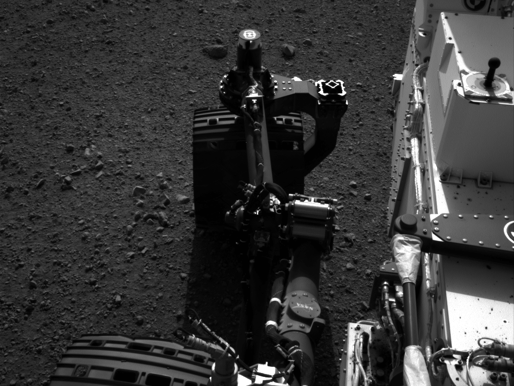
Click to animate: this gif image shows the movement of the rear right wheel of NASA’s Curiosity as rover drivers turned the wheels in place at the landing site on Mars. Image credit:NASA/JPL-Caltech

She turned her right rear wheel in and turned her right rear wheel out in a sort of Hokey-Pokey-like action in preparation for actually moving inside Gale Crater. Yesterday, the Curiosity rover’s first movements was this “wiggle” of each of the four corner wheels for the first time. Curiosity Mission Manager Michael Watkins said this was a test of the steering actuators on the wheels, and was critical preparation for Curiosity’s first drive on Mars.

Late last night, the rover team sent commands for doing the first drive, and we’ll likely have information on whether that first drive was successful, as JPL has a news conference planned for 17:00 UTC, 1 pm EDT on Wednesday.

Below is a video animation of the rover’s first arm movements, as well:

Other news from the press conference yesterday is that all the instruments are working well on the rover so far, except for one of the instruments on the weather station.

One of the two sets of Rover Environmental Monitoring Station (REMS) wind sensors is not providing data. “One possibility is that pebbles lofted during the landing hit the delicate circuit boards on one of the two REMS booms,” said Curiosity Deputy Project Scientist Ashwin Vasavada of NASA’s Jet Propulsion Laboratory, Pasadena, Calif. “We will have to be more clever about using the remaining wind sensor to get wind speed and direction.”

The rover’s weather station, build by researchers in Spain, checks air temperature, ground temperature, air pressure, wind and other variables every hour at the landing site in Gale Crater. On a typical Martian day, or “sol,” based on measurements so far in the two-week old mission, air temperatures swing from minus 2 to minus 75 Celsius (28 degrees to minus 103 degrees Fahrenheit). Ground temperatures change even more between afternoon and pre-dawn morning, from 3 to minus 91 Celsius (37 degrees to minus 132 degrees Fahrenheit ).

“We will learn about changes from day to day and season to season,” said Javier Gómez-Elvira of the Centro de Astrobiología, Madrid, Spain, principal investigator for REMS.

The team predicts that within a week or so, daily Mars weather reports from Curiosity will become available at this website: http://cab.inta-csic.es/rems/marsweather.html or bit.ly/RzQe6p.

Another instrument provided by Russia is checking for water bound into minerals in the top one meter (three feet) of soil beneath the rover. It employs a technology that is used in oil prospecting on Earth, but had never before been sent to another planet.

“Curiosity has begun shooting neutrons into the ground,” said Igor Mitrofanov of Space Research Institute, Moscow, principal investigator for this instrument, called the Dynamic Albedo of Neutrons, or DAN. “We measure the amount of hydrogen in the soil by observing how the neutrons are scattered, and hydrogen on Mars is an indicator of water.”

The most likely hydrogen to be found in shallow ground of Gale Crater, near the Martian equator, is in hydrated minerals. These are minerals with water molecules, or related ions, bound into the crystalline structure of rocks. They can tenaciously retain water from a wetter past after all free water has gone.

With plans for Curiosity to begin roving, there will soon be new places for all the instruments to measure. The rover team explained the first real drive today will be a very simple execution: forward about 3 meters, then a turn in place of 90 degrees to the right, then a 2-meter drive backwards. Estimates are the rover will end up about 3 meters from its current position and be facing south instead of east.

Emily Lakdawalla has a nice 4-view animation of the rover’s wheel wiggle, showing three wheels and how the shadow of the rover itself moved.

Want To Live On Mars Time? There’s An App For That

Screenview from Mars Clock, available from the Apple Store, that displays Mars time.

You’ve listened to all of JPL’s Curiosity telecons, you can recite the nail-biting sequence of events during MSL’s “Seven Minutes of Terror,” and you’ve devoured thousands of pixels of image data beamed back to Earth. But are you ready to live on Mars time? With a couple of well-timed apps from Google Play and Apple’s app store, you can.

MarsClock, available for Android devices at Google play is a free app written by Scott Maxwell, rover driver for Curiosity. The app, which has been downloaded between 1,000 and 5,000 times, lets you see times for all three of NASA’s Mars Rovers, Spirit, Opportunity and Curiosity. The app allows the user to set single alarms or alarms that repeat every sol. A sol is a full Martian day which is about 24 hours, 39 minutes in Earth time.

Perhaps you shun Android devices for your Apple device whether it’s an iPhone, iPad or iPod. Never fear, you too can be everyone’s favorite Martian living on Mars time. Mars Clock, by SunlightAndTime, is a 99-cent app that displays Mars time and a host of other Mars time goodies. Features include local mean solar time for the rover, coordinated Mars time, sunrise and sunset times for the Curiosity landing site (I think this might be the coolest feature), current season, a countdown to landing feature (which is counting up since MSL landed on Mars on August 5th), current Earth time, a distance calculator between the Earth and Mars and radio communications delay estimate.

While it might be hard to add 40 minutes to your day to live as a Martian or as the JPL team that operates the Curiosity rover, these apps sure do make it more fun.

First Full (Raw) View of Mt. Sharp from Curiosity

The latest raw images downloaded from the Curiosity rover provides the first full view of Mt. Sharp (Aeolis Mons). Stuart Atkinson has stitched together images from the Navigation Camera to give us the first full look at Gale Crater’s central mound.

Another image wizard, Damien Bouic has created a truly spectacular view of Mt. Sharp, which includes parts of the rover itself and the blazing Sun. This image comes from forward Hazard Avoidance camera on the day of the landing. It’s a wide-angle, fisheye camera, according to Emily Lakdawalla, and while it is a low-resolution image, the “poster” Bouic created is truly stunning.

But as Stu points out on his new and wonderful blog “The Gale Gazette,” while we can now see the full northern face of the mountain, we’re not actually seeing all of Mt. Sharp nor the highest peak. “This isn’t the summit at all. Far from it,” Stu writes.

The actual summit is hidden by the highest point visible to Curiosity, and is just the ‘front’ of Mt Sharp as seen from Curiosity’s landing site.

See Stu’s image below for analysis:

Caption: Google Mars view of Curiosity’s landing site and Aeolis Mons. Annotations by Stuart Atkinson.

What this means is that Curiosity probably won’t ever really see the the highest point on Aeolis Mons… unless she’s a really great mountain climber and has a really long extended mission, making it to the highest point now visible from the landing site.

“I’m a bit worried that we won’t get to see that summit at all,” Stu wrote. “The closer we get to Mt. Sharp’s base, the more mountain will be between us and the summit. And once Curiosity reaches the foothills of the mountain, the viewing angle will just be completely wrong, the summit will be hidden by the rising terrain.”

There’s also a wonderful color image put out by JPL and Malin Space Science Systems yesterday:

Caption: Curiosity’s 34-millimeter Mast Camera acquired this high-resolution image on Aug. 8, 2012 PDT showing layered deposits. A scale bar indicates a distance of 2 kilometers (1.2 miles). Image Credit: NASA/JPL-Caltech/MSSS

This image is taken from a mosaic and shows the view from the landing site of NASA’s Curiosity rover toward the lower reaches of Mount Sharp, where Curiosity is likely to begin its ascent through hundreds of meters of layered deposits. The lower several hundred meters show evidence of bearing hydrated minerals, based on orbiter observations. The terrain Curiosity will explore is marked by hills, buttes, mesas and canyons on the scale of one-to-three story buildings, and as MSL’s John Grotzinger said yesterday at the Curiosity press conference, the view looks very much like the Four Corners region of the western United States.

JPL did do a little processing of this image however, and shows the colors modified as if the scene were transported to Earth and illuminated by terrestrial sunlight. This processing, called “white balancing,” is useful to scientists for recognizing and distinguishing rocks by color in more familiar lighting.

You can see more images from Curiosity at the JPL Photojournal, and also see the latest raw views here. The wonderful photo-magicians at UnmannedSpaceflight.com are having a marvelous time with all the new images from Curiosity, and you can always see what they’ve come up with — which includes multiple mosaics and color versions hot off the photons of the latest raw images from MSL. Emily Lakdawalla at the Planetary Blog is also working her imaging processing software to the max, so check out her latest posts, too!

Two New Videos Show Curiosity’s Touchdown and Heat Shield Hitting Mars

Wow, this is better than any theatrical movies of fictional ships landing on Mars, because this is REAL! The images and videos from the Mars Descent Imager (MARDI) camera on the Mars Science Laboratory spacecraft keep getting more amazing as the science team goes through their data and refines all the awesome action events from landing that the camera was able to capture. The video above is from a sequence of images which shows Curiosity’s heat shield slamming into the surface and raising a cloud of dust!! MARDI took the images while the rover was still suspended on a parachute and, of course, after the spacecraft had jettisoned the heat shield.

We also have a full resolution color MARDI image below which was sent to us by Rolf Wahl Olsen, pointing out where the heat shield is sitting on the surface.

And another great video below is of Curiosity gently touching down on Mars. This was also taken by MARDI and is a higher resolution version that what was previously available. MARDI is on the bottom of the rover, so you see the surface of Mars coming up at you, and then see the dust swirling as the sky crane’s rocket thrusters blasted the Mars regolith. Additionally, on the descent, one of the rover’s wheel’s comes into view as it unfolds in preparation for landing! Awesome!

UPDATE: (Aug. 19)

This video was put together by Doug Ellison of UnmannedSpaceflight.com, which shows Curiosity’s entire descent, starting with the heat shield jettison until touchdown and provides a “smoother” view of the entire landing:

Caption: High resolution image from MARDI of Curiosity’s descent. Credit: NASA/JPL/MSSS

Click on the image for a larger version, or see the original raw version here. “It’s the little back irregular spot in the middle near the bottom edge,” Olsen said. “It’s not in the image before that, and it fits perfectly with the ‘crime scene’ photo released earlier,” which you can see here. If you look closely, the impact crater is even visible in this image!

Mohawk Guy Provides Update on Curiosity Rover

JPL’s Bobak Ferdowsi — famous for the star-spangled Mohawk hairdo he sported on Curiosity’s landing night — provides an update on what the newest Mars rover has been up to (checking out instruments) and how next week should include big moments like the first test drive and firing up that laser.

In addition to great hair, Ferdowsi is a Flight Director for the Curiosity rover team.

Ferdowsi in JPL’s Mission Control during Curiosity’s landing.

Curiosity’s Landing Through the Eyes of One of Her 3,000 Builders

We all have seminal moments that mark our lives; some just are way more cool than others. Mark Rober designs spacecraft at the Jet Propulsion Laboratory and is just one of over 3,000 people who helped design, build, tweak, launch, navigate and land the Curiosity Rover on Mars. “I spent 7 years working NASA’s Curiosity Rover,” Rober said via Twitter. “I made this video to try to capture what it felt like to see her land.”

Seven years of his life came down to seven minutes of terror… or in Mark’s case, seven minutes of shivering.

Congrats, Mark, and to all your thousands of compatriots. Thanks for sharing the journey with the rest of us.

Curiosity sees Mount Sharp Up Close and gets ‘Brain Transplant’

Image Caption: Mosaic of Mount Sharp inside Curiosity’s Gale Crater landing site. Gravelly rocks are strewn in the foreground, dark dune field lies beyond and then the first detailed view of the layered buttes and mesas of the sedimentary rock of Mount Sharp. Topsoil at right was excavated by the ‘sky crane’ landing thrusters. Gale Crater in the hazy distance. This mosaic was stitched from three full resolution Navcam images returned by Curiosity on Sol 2 (Aug 8) and colorized based on Mastcam images from the 34 millimeter camera. Processing by Ken Kremer and Marco Di Lorenzo. Credit: NASA/JPL-Caltech/Ken Kremer/Marco Di Lorenzo

The Curiosity rover has beamed back the first detailed images of Mount Sharp, offering a stupendous initial view of her ultimate driving goal, and is now in the midst of a crucial “brain transplant” this weekend that will transform her into a fully operational rover.

The science team will direct the six-wheeled Curiosity to begin climbing Mount Sharp at some later date during the rovers’ two year primary mission after traversing and extensively investigating the floor of her landing site inside Gale Crater.

See our mosaic focusing on the base of Mount Sharp using three full resolution images snapped by the Navcam navigation camera located on the newly erected camera and instrument mast with colorization based on the 34 millimeter Mastcam color camera.

Curiosity came to rest almost flat on the martian surface, but with a slight 3 degree tilt down in the front and the images thus far are taken from that preprogrammed viewpoint, roughly some six miles or so from the base of Mount Sharp.

The terrain is strewn with small pebbles that may stem from a nearby alluvial fan through which liquid water flowed long ago, scientist think. Observations from orbit with NASA’s Mars Reconnaissance Orbiter have identified clay and sulfate minerals in the lower layers of Mount Sharp, indicating a wet history. At higher elevations, scientists hope to discover a boundary layer and indications of what led to the “Great Dessication Event” and loss of liquid water on the ancient Martian surface.

This weekend Curiosity has also begun transmitting spectacular hi res Mastcam images that will far exceed anything else thus far. Here is the Mastcam 360 pano as assembled by NASA so far:

Image Caption: First Hi-Res Color Mosaic of Curiosity’s Mastcam Images. NASA/JPL-Caltech/MSSS

But before the car-sized robot can actually rove around, reach out with her 7 foot (2 meter) long instrument loaded arm and scoop up samples for analysis by the on board chemistry labs she needs the software smarts to accomplish the science tasks.

With all the initial post landing objectives accomplished, engineers at NASA’s Jet Propulsion Lab in Pasadena, Calif., are spending 4 Sols, or Martian days, bracketing this weekend to upload a new software package named “R10” that is optimized for surface operations and will replace the current “R9” package.

“We designed the mission from the start to be able to upgrade the software as needed for different phases of the mission,” said Ben Cichy of NASA’s Jet Propulsion Laboratory in Pasadena, Calif., chief software engineer for the Mars Science Laboratory mission. “The flight software version Curiosity currently is using [R9] was really focused on landing the vehicle. It includes many capabilities we just don’t need any more. It gives us basic capabilities for operating the rover on the surface, but we have planned all along to switch over after landing to a version of flight software that is really optimized for surface operations.”

Software on both the primary and backup computers is being carefully upgraded in step by step stages. He said an initial “toe dip” on Friday to test the upgrade was the first step.

“R10 is optimized for surface operations and has what the science team wants. It’s being downloaded over the next four Sols to enable this fantastic mission,” Cichy said at a JPL news briefing on August 10. They will stand down on science for the next four Sols during the installation.

“Right now, we have the capability in our basic surface software to check out the health of the instruments, but we don’t really have the capability to go and make the full use of all this great hardware we shipped to Mars.”

“So the R10 software gives us the capability to use the robotic arm fully, to use the drill, to use the dust removal tool, to use the whole sampling chain and injest the samples and analyze them, all this exciting stuff this mission will do.”

“Curiosity is a Martian mega rover and born to drive ! R10 gives us the ability to drive autonomously and use images to detect hazards and drive safely.”

So far, the software upgrade is going as planned this weekend.

Curiosity made an unprecedented pinpoint landing inside Gale Crater on Aug. 5/6 using the rocket powered “Sky Crane” descent stage that lowered Curiosity by cables onto the Red Planet’s surface exactly as planned on the plains astride Mount Sharp just a few miles from the base of the gigantic mountain.

Mount Sharp covers much of the interior of the 96 mile wide (154 km) Gale Crater. The peak of the 3.4 mile (5.5 km) high layered mountain is taller than Mount Whitney in California.

For comparison, see Curiosity’s initial wider field post-landing shots of Mount Sharp in 2 D and 3 D from the lower resolution fish-eye Hazcam cameras, here

NASA’s 1 ton mega rover Curiosity is the biggest and most complex robot ever sent to the surface of another planet, sporting a payload of 10 state of the art science instruments weighing 15 times more than any prior roving vehicle. Curiosity’s goal is to determine if Mars was ever capable of supporting microbial life, past or present and to search for the signs of life in the form of organic molecules.

Ken Kremer

Amazing Sharper View of MSL Hanging by its Parachute

I have to steal a phrase from Phil Plait, the Bad Astronomer, who earlier this week said something like, “Things just can’t keep getting more cool all the time, right?”

Well, apparently they can. Here’s a sharpened view from HiRISE of the Mars Science Laboratory descending to Mars on a parachute. It shows greater detail of the parachute and even MSL itself.

Just wow.

The original image cropped image:

The HiRISE team describes how they sharpened the image: “This image was given special processing by members of the HiRISE Team, that included removing detector noise and optical blur. The sharpening was achieved by converting the image to its frequency components, correcting for the minor blur that was characterized by pre-flight laboratory measurements, and converting back.”

All I know is that it’s awesome.

See our article on the original image and how the team captured it.

See more details at the HiRISE website.

Ironic Science Reality: Flying Saucers on Mars from Earth

“Irony: The first real flying saucer is from Earth. And it landed on Mars.”

That’s a quote we saw via UT writer Ray Sanders, from a great graphic making its way around the internet. But amazingly, it’s true. Above is a high resolution image from the Mars Science Laboratory’s MARDI instrument showing the heat shield falling away from the spacecraft and heading towards Mars, looking like a classic flying saucer UFO. This image shows the 4.5-meter (15-foot) diameter heat shield when it was about 16 meters (50 feet) from the spacecraft.

The image shows so much detail that “You can actually see the stitching in the thermal blanket and some wiring” said Mike Malin during a press conference at JPL today.

Here’s a new, higher resolution video of the heat shield’s descent from what was previously available:

This image shows the inside surface of the heat shield, with its protective multi-layered insulation. The bright patches are calibration targets for MARDI. Also visible is the Mars Science Laboratory Entry, Descent, and Landing Instrument (MEDLI) hardware attached to the inside surface.

Malin said that at this range, the image has a spatial scale of 0.4 inches (1 cm) per pixel. It is the 36th MARDI image, obtained about three seconds after heat shield separation and about two and one-half minutes before touchdown.

Emily Lakdawalla has another image that she “tweaked” that shows another look at the heat shield when it is farther away from MSL:


Caption: MSL’s heat shield falling towards Mars. Credit: NASA/JPL/MSSS/Emily Lakdawalla

“It is still mind-blowing to think that this snapshot was taken by a spacecraft flying in the air above a different planet,” Emily wrote on the Planetary Blog.

In other MSL news, Curiosity’s mast is deployed, evidenced by this shadow self-portrait:

And also from the images from the Navigation Cameras on the mast:

At the press conference, Curiosity’s Chief Scientist John Grotzinger said the view reminded him of the Mojave Desert, and remarked on the striking familiarity of an almost “Earth-like” plain with the crater rim in the distance. There also appears to be a little haze in the air that Grotzinger likened to “LA smog.”

Jason Major also posted a panoramic view of Curiosity’s surroundings by combining a couple of shots from the Navigation cameras.

And here’s that great graphic by Ken Watson:

Here’s where you can find more of the latest images from MSL.

Curiosity’s Target Martian Destination

Where will the Mars Science Laboratory Curiosity rover land? This annotated image of Mars by Efrain Morales shows where on Mars Curiosity will set down, if all goes well, at about 05:31 UTC on Aug. 6 (10:31 p.m. PDT on Aug. 5, 1:31 a.m. EDT Aug. 6). (Use this handy time conversion chart to find the ETA in your time zone.) The landing site is 4.6 degrees south latitude, 137.4 degrees east longitude, near base of Aeolis Mons, also known as Mount Sharp, a layered mountain that rises 4.8 kilometers (3 miles), inside Gale Crater.

Thanks to Efrain for sharing his image. Check out more of his work at the Jaicoa Observatory website.