
The folks from UnmannedSpaceflight.com have been busy working on the new images of Phobos returned by Mars Express. Above, is an animation created by Daniel Machácek, who also colorized the images and processed them through some morphing software to make a seamless animation (via Emily Lakdawalla from the Planetary Blog), and below is another morphing animation by Daniel Brennan (via the Mars Express Blog)
Continue reading “Morphing Phobos”
New Looks at Phobos from Mars Express Flyby
[/caption]
The Mars Express team released the images today from the close flyby the spacecraft made of Phobos on January 9. The images weren’t downloaded from Mars Express until Jan. 18, and then they were processed, so these are hot off the press. The team didn’t provide much explanation, but enjoy the images. There’s one 3-D view in the group, so grab your 3-D glasses.
")
")
")
Here’s the on 3-D view, and the team explained that due to the stereo viewing geometry during the flyby a small part of the moon’s edge is only visible for the right eye resulting in odd 3D-perception in this area. This part has been slightly adjusted for better viewing. Also, for the left eye at the left edge of the image four small data gaps have been interpolated.
Source: ESA
Mars Express Set for Phobos Flyby
[/caption]
The Mars Express spacecraft will be making a very close flyby of the moon Phobos Sunday, January 9, 2011, at a distance of only 111 km from the center of the moon. The spacecraft actually is having eight different fairly close flybys of Phobos between December 20, 2010 and 16 January 2011, but this is the closest of that group. The Sunday buzz-by will be the third closest that Mars Express has performed during its time in orbit at Mars. The flyby speed will be about 3 km/s.
Olivier Witasse, ESA Project Scientist for Mars Express did a Q&A about the flyby with the Mars Express blog, which we’ll post below.
Q: What is the prime objective of this fly-by?
Witasse: The prime objective is to obtain high-resolution data from all remote sensing instruments, and especially to acquire what we hope will be spectacular images using the High Resoultion Stereo Camera (HRSC).
Q: What do the camera team hope to achieve?
Witasse: The HRSC camera will cover the southern hemisphere, which has not been well imaged during previous encounters. It should achieve a ground resolution of about a few metres per pixel. The emphasis will be on stereo imaging. These new data will improve the Phobos elevation model. This time, no colour data will be taken.
Q: Will any other instruments be working?
Witasse: The OMEGA, PFS and SPICAM experiments will acquire new data in the ultraviolet, visible and infrared ranges. This will significantly improve a data set used to map the surface temperatures. Also, and this is very important, the data are being used to find out the composition of Phobos. This is a very difficult exercise, because the spectra lack the obvious signatures of known components such as minerals.
The MARSIS radar will also be working, attempting to obtain echoes from beneath the surface. To complete the picture, the ASPERA experiment will record signatures of the interaction between the solar wind and Phobos, by detecting solar wind particles bouncing off the surface.
All these new data can help unlock the origin of the Martian moons, and will certainly support the Russian sample return mission, Phobos-Grunt, expected to be launched later this year. Unfortunately, the Phobos-Grunt landing site will be at the fringes of view this time and so poorly illuminated.
Q: Why no radio science this time?
Witasse: Given the design of the Mars Express spacecraft, we always have to make a choice between radio-science and remote sensing. In other words, we cannot point the camera towards the target and the high-gain antenna towards Earth at the same time.
For this particular flyby, at 111 km, we decided to give priority to remote sensing for many reasons. Flybys over the illuminated side of Phobos obviously favour the operations of the imagers and spectrometers. Also, the altitude of this flyby is not ideal for radio-science. To improve the gravity data set, we would need to fly below 60 km. Furthermore, at the moment Mars is far from Earth and close to the Sun (as seen from Earth), making the quality of radio-signal unsuitable for a detailed scientific analysis.
——————
In another blog post, the Mars Express team said to expect no pictures from the flyby until January 21, because the whole Phobos data set won’t be downloaded to Earth until January 18. The HRSC team will then process the data, and we can expect a release of images (including a 3D view) on Friday, 21 January.
Source: Mars Express Blog
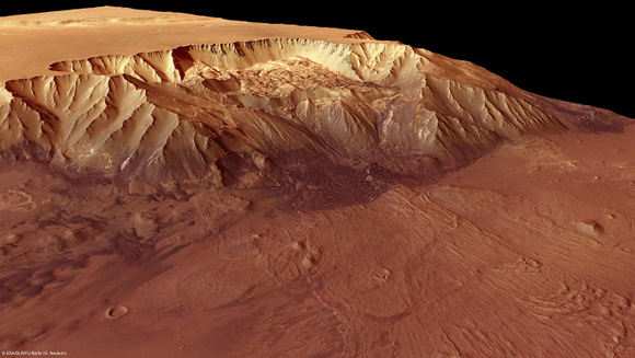
Melas Chasma: The Deepest Abyss on Mars
[/caption]
Melas Chasma is part of the huge Valles Marineris that cuts into the middle of Mars surface, making it a pretty interesting place: there is abundant evidence for water having flowed here, with ancient water-cut channels visible even from orbit. Also visible are landslides that have created huge fans of rubble at the base of the cliffs. These newest images from ESA’s Mars Express show Melas Chasma, which sinks 9 km below the surrounding surface, making it one of the lowest depressions on the planet. This is just a small part of the bigger Valles Marineris, which stretches for more than 4,000 km across the surface of Mars. Around Melas Chasma, there are lighter-coloured deposits of sulphate components that were probably deposited in a former lake.
")
These images were captured in 2006 and just released by the Mars Express team. See more details and images at the ESA website.
Mars ‘Hide and Seek’ Ice Cap Affected by Winds and Water

[/caption]
Mars has permanent ice caps at both poles composed mostly of solid carbon dioxide, and mysteriously, a large portion of the northern cap disappears early in the northern Martian spring followed later by its sudden reappearance. Scientists may have solved this mystery, saying that strong winds and Mars’ active water cycle may play a part in ‘come and go’ polar cap.
Earlier this year, another group of scientists from the University of Texas found that so-called katabatic winds — a wind that carries high density air from a higher elevation down a slope under the force of gravity – were responsible for the formation of giant swirls or troughs in the northern polar cap, as well as a huge chasm that is also visible. Those winds may also play a part in the regeneration of the ice cap.
Seasonal ice deposits play a major role in the water cycle of the planet. Every Martian year, alternatively during northern and southern winter, a significant part of the atmosphere condenses on the surface in the form of frost and snow. These seasonal ice deposits, which can be up to one meter thick, are mainly composed of carbon dioxide with minor amounts of water and dust. During spring, the deposits sublimate becoming a substantial source of water vapor, in particular in the northern hemisphere of the planet.
 in the spiral troughs structure of the North polar cap.")
Dr. Bernard Schmitt and Mr. Thomas Appéré analyzed data taken with the OMEGA instrument on board ESA’s Mars Express, honing in on two northern Martian regions. Before the Mars Express mission, scientists monitored the evolution of the seasonal deposits by looking at the albedo (reflectivity) and temperature changes of the surface, as the ice deposits appear much brighter and are colder than the surrounding defrosted terrains.
The first Martian region that the scientists observed is located on Gemina Lingula, a Northern plateau, where a peculiar evolution of the carbon dioxide ice deposits was observed.
“During spring the ice signature disappeared from our data, but the surface temperature was still cold enough to sustain plenty of CO2 ice,” said Schmitt. “We concluded that a thick layer of something else, either dust or water ice was overlaid. If it was dust then it would also hide water ice and the surface of the planet would become darker. None of these happened so we concluded that a layer of water ice was hiding the CO2 ice. We had to wait until the weather gets warm enough on Mars for the water to vaporize as well, and then the carbon dioxide signatures re-appeared in our data.”
Soon after spring sunrise, the solar radiation hitting the surface of Mars warms enough the CO2 ice lying on the top layer to cause it to vaporize. But the water ice needs higher temperatures to sublimate, so a fine grained layer of water ice gradually forms hiding the carbon dioxide ice still lying beneath it.
“A layer only 2 tenths of a millimeter thick is enough to completely hide the CO2 ice. Also some water that has been vaporized at lower, warmer, Martian latitudes condenses as it moves northward and may be cold trapped on top of the CO2 ice,” said Appéré.
The second region analyzed by the team is located in the spiral troughs structure of the North permanent cap. A similar situation was observed but the carbon dioxide ice re-appeared very quickly here after its initial disappearance.
“This hide-and-seek game didn’t make much sense to us. It wasn’t cold enough for CO2 ice to condense again, neither warm enough for water ice to sublimate,” said Schmitt.
 Simulation of katabatic (downhill) winds. Colour bar: friction velocity from 0.1 to 0.6 m/s. (b) Localization of regions where early disappearances (blue) and sudden reappearances (orange) of the carbon dioxide ice signature are observed.")
“We concluded that somehow the water ice layer was removed,” said Appéré. “The topography of the North permanent Martian cap is well-suited to entail the formation of strong katabatic winds.”
Another scientist, Dr. Aymeric Spiga, used a model to simulate those winds and he indeed confirmed the sudden re-appearances of CO2 ice where strong katabatic winds blow.
This is just the first step in figuring out exactly how the polar cap disappears and reappears on Mars.
“To decipher the present and past water cycles on Mars and improve our weather models on the planet, one needs to have a good understanding of the seasonal ice deposits dynamics, how they change in space and time,” said Schmitt. “We are confident that our results will make a significant contribution in this direction.”
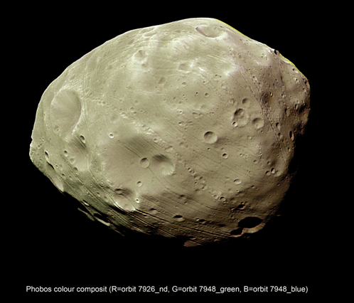
New Theory Says Phobos Formed From Re-Accretion of Impact Debris
[/caption]
Most theories on the formation of Phobos and its sister moon of Mars, Deimos, hold that the two moons did not form along with Mars, but were captured asteroids. However, new research indicates that Phobos formed relatively near its current location via re-accretion of material blasted into Mars’ orbit by some catastrophic event, such as a huge impact. This could be an event similar to how Earth’s moon formed. Thermal infrared spectra data from two Mars missions, ESA’s Mars Express and NASA’s Mars Global Surveyor have provided independent researchers similar new conclusions of how Phobos formed.
The origin of the two Martian satellites has been a long standing puzzle. Previous researchers have postulated that because of Phobos small size and highly cratered surface, as well as the fact that Mars is reasonably close to the asteroid belt, that Phobos was a captured asteroid. Recently, alternative scenarios suggested that both moons were formed in-situ by the re-accretion of rocky-debris blasted into Mars’s orbit after a large impact or by re-accretion of remnants of a former moon which was destroyed by Mars’s tidal force.
Today, Dr. Giuranna from the Istituto Nazionale di Astrofisica in Rome, Italy, and Dr. Rosenblatt from the Royal Observatory of Belgium presented their new findings at the European Planetary Science Congress in Rome, saying that the thermal data from the two spacecract, as well as the measurements of Phobos’ high porosity from the Mars Radio Science Experiment (MaRS) on board Mars Express, supports the re-accretion scenario.
“Understanding the composition of the Martian moons is the key to constrain these formation theories,” said Giuranna.

Previous observations of Phobos at visible and near-infrared wavelengths suggest the possible presence of carbonaceous chondritic meteorites, carbon-rich and likely from the early formation of the solar system, commonly associated with asteroids dominant in the middle part of the asteroid belt. This finding would support the early asteroid capture scenario. However recent thermal infrared observations from the Mars Express Planetary Fourier Spectrometer, show poor agreement with any class of chondritic meteorite. They instead argue in favor of the in-situ scenarios.
“We detected for the first time a type of mineral called phyllosilicates on the surface of Phobos, particularly in the areas northeast of Stickney, its largest impact crater,” said Giuranna. “This is very intriguing as it implies the interaction of silicate materials with liquid water on the parent body prior to incorporation into Phobos. Alternatively phyllosilicates may have formed in situ, but this would mean that Phobos required sufficient internal heating to enable liquid water to remain stable. More detailed mapping, in-situ measurements froma lander, or sample return would ideally help to settle this issue unambiguously.”
But other observations appear to match up with the types of minerals identified on the surface of Mars. From that data, Phobos appears more closely related to Mars than objects from other locations in the solar system.
“The asteroid capture scenarios also have difficulties in explaining the current near-circular and near-equatorial orbit of both Martian moons,” said Rosenblatt.
The MaRS instrument used the frequency variations of the radio-link between the spacecraft and the Earth-based tracking stations in order to precisely reconstruct the motion of the spacecraft when it is perturbed by the gravitational attraction of Phobos, and from this, the team was able provide most precise measurement of Phobos’ mass, with a precision of 0.3%.
Additionally, the team was able to give the best estimate yet of Phobos’s volume, with a density of 1.86±0.02 g/cm3.
“This number is significantly lower than the density of meteoritic material associated with asteroids. It implies a sponge-like structure with voids making up 25-45% in Phobos’ interior,” said Rosenblatt.
“High porosity is required in order to absorb the energy of the large impact that generated Stickney crater (the large crater on Phobos) without destroying the body,, said Giuranna. “In addition a highly porous interior of Phobos, as proposed by the MaRS team, supports the re-accretion formation scenarios”.
The researchers said a highly porous asteroid would have probably not survived if captured by Mars. Alternatively, such a highly porous Phobos can result from the re-accretion of rocky-blocks in Mars’ orbit. During re-accretion, the largest blocks re-accrete first because of their larger mass, forming a core with large boulders. Then, the smaller debris re-accrete but do not fill the gaps left between the large blocks because of the low self-gravity of the small body in formation. Finally, a relatively smooth surface masks the space of voids inside the body, which then can only be indirectly detected. Thus, a highly porous interior of Phobos, as proposed by the MaRS team, supports the re-accretion formation scenarios.
The researchers said they would like more data on Phobos to verify their findings, and the upcoming Russian Phobos-Grunt mission (Phobos Sample Return), scheduled for launch in 2011, will help to provide more understanding regarding the origin of Phobos.
Source: Europlanet Conference
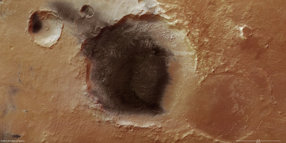
Weird Crater on Mars is a Mystery

[/caption]
This is one of the strangest looking craters ever found on Mars, and this platypus-tail-shaped depression, called Orcus Patera, is an enigma. The term ‘patera’ is used for complex or irregularly shaped volcanic craters, but planetary scientists aren’t sure if this landform is volcanic in origin. Orcus Patera lies between the volcanoes of Elysium Mons and Olympus Mons, but its formation remains a mystery. This is the latest image of the object, taken by ESA’s Mars Express.
It could be an impact crater that originally was round, but then subsequently deformed by compressional forces. Or, it could have formed from two craters next to each where the adjoining rims eroded. However, the most likely explanation is that it was made in an oblique impact, when a small body struck the surface at a very shallow angle.
")
It is 380 km long by by 140 km wide, and has a rim that rises up to 1,800 meters above the surrounding plains, while the floor of the depression lies 400–600 m below the surroundings. The floor of the depression is unusually smooth.
The image above was created using a Digital Terrain Model (DTM) obtained from the High Resolution Stereo Camera on ESA’s Mars Express spacecraft. Elevation data from the DTM are color-coded: purple indicates the lowest-lying regions, and beige the higher elevations. The scale is in meters.
Source: ESA
Mars Webcam Provides Astronaut-like View of Red Planet
What would it be like to approach Mars in a spacecraft? In one of the coolest movies ever, we now know! Using the the Visual Monitoring Camera (VMC) on board Mars Express, science teams put together 600 individual still images to create a movie of descending towards and then moving away from Mars. It shows the spacecraft’s slow descent from high above the planet, speeding up as closest approach is passed and then slowing down again as the distance increases.
Continue reading “Mars Webcam Provides Astronaut-like View of Red Planet”
New Views of Meridiani Planum Show Deposits of Volcanic Ash
[/caption]
Earth isn’t the only place we’re seeing volcanic ash these days. New high resolution color images from ESA’s Mars Express of Meridiani Planum on Mars – the Opportunity rover’s neighborhood — shows evidence of volcanic ash in a small impact crater that is about 50 km wide. The wind-blown dark material also provides clues to the prevailing wind direction in this region of Mars. These images are stunning, especially in the large hi-resolution versions, so click on each image to see Mars up close and personal.
")
Mars is only about one-half the size of Earth, but yet has several volcanoes larger than anything we have on our home planet. The most massive volcanoes are located on huge uplifts or domes in the Tharsis and Elysium regions of Mars. Meridiani Planum lies close to Tharsis, and is a large plain at the northern edge of the southern highlands of Mars.
Poking through the dark covering are small mounds, probably made of harder, more resistant material. The softer material around them has been eroded and blown out of the crater by north-easterly winds and now lies outside the crater, forming dark streaks at the bottom left of the image.
This dark crater is close to Mars’ equator, and early on this area was chosen as a central reference point for Mars’ geographical coordinate system, so the martian prime meridian runs right through here. Hence the name “Meridiani.”
Meridiani Planum extends 127 km by 63 km and covers an area of roughly 8000 sq km
")
Three craters stretch across Meridiani Planum, as seen in this image. The nearest is an old crater, almost worn away. It is 34 km across. The second is covered in dark material, most likely a substance resembling volcanic ash. It is 50 km wide. The third crater, more distant, is smaller at 15 km wide. Again it possesses a dark floor, perhaps because material from the largest crater has been blown out by the wind and has settled in the smallest one.
The image below gives a broader perspective of the area. The color images were actually taken in 2005 and were just recently released by ESA.
/MOLA")
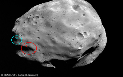
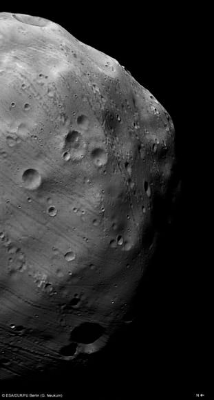
New Images of Phobos from Mars Express Flyby
[/caption]
ESA released new images of Mars’ moon Phobos, taken during the Mars Express March 7, 2010 flyby, showing the rocky moon in exquisite detail and also in 3-D. Mars Express orbits the Red Planet in a highly elliptical, polar orbit that brings it close to Phobos every five months, and it is the only spacecraft currently in orbit around Mars whose orbit reaches far enough from the planet to provide a close-up view of Phobos. Like our Moon, Phobos always shows the same side to the planet, so only by flying outside the orbit is it possible to observe the moon’s far side. Mars Express did such flybys on March 7, 10 and 13. Get out your 3-D glasses for a great look at Phobos, below.
 onboard the ESA spacecraft Mars Express. Credits: ESA/DLR/FU Berlin (G. Neukum)")
Phobos is an irregular body measuring some 27 × 22 × 19 km. Its origin is debated. It appears to share many surface characteristics with the class of ‘carbonaceous C-type’ asteroids, which suggests it might have been captured by Mars. However, it is difficult to explain either the capture mechanism or the subsequent evolution of the orbit into the equatorial plane of Mars. An alternative hypothesis is that it formed around Mars, and is therefore a remnant from the planetary formation period.
")
In 2011 Russia will send a mission called Phobos–Grunt (meaning Phobos Soil) to land on Phobos, and an experiment will collect a soil sample and return it to Earth for analysis.
Phobos-Grunt will also carry with it The Planetary Society’s LIFE experiment which will test the survivability of microorganisms in the conditions of deep space. The experiment is a study of the panspermia hypothesis, which posits that microorganisms have traveled between planets sheltered deep inside space rocks.
For operational and landing safety reasons, the proposed landing sites were selected on the far side of Phobos within the area 5°S-5°N, 230-235°E. But new HRSC images showing the vicinity of the landing with better illumination from the Sun that previous images, which will provide valuable views and information for mission planners.
Mars Express will continue to encounter Phobos until the end of March, when the moon will pass out of range. During the remaining flybys, the high-resolution camera and other instruments will continue to collect data.
Source: ESA