Videopalooza Shows Off Phobos Flyby As Moon’s Mysterious Origins Probed

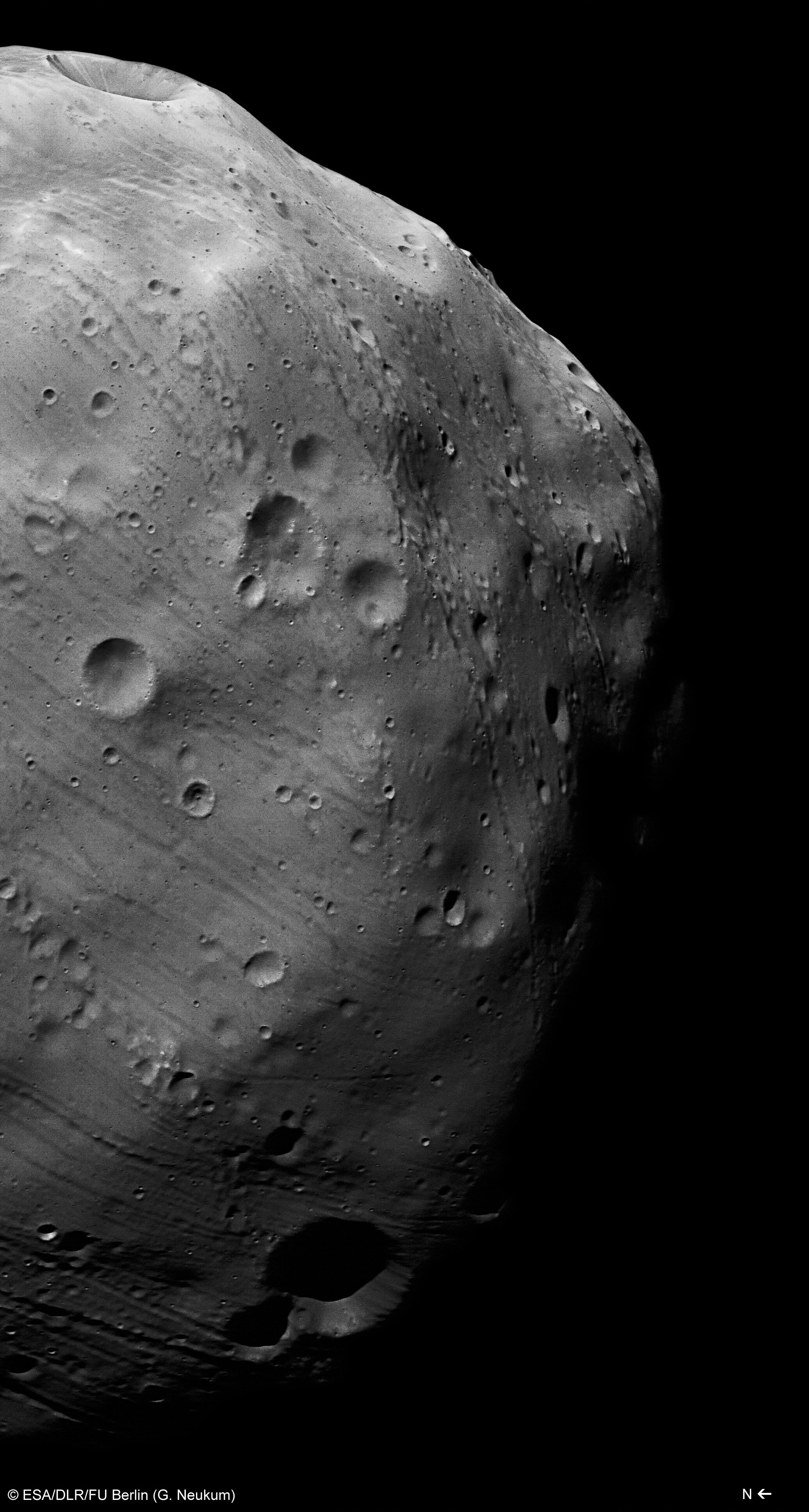
There won’t be any pictures out of this close encounter, but the animations sure were spectacular. The European Space Agency’s Mars Express spacecraft skimmed just 45 kilometers (28 miles) above the surface of the moon Phobos yesterday, and through these various videos you can see what the orbital trajectory would have looked like during that time.

“The flyby on 29 December will be so close and fast that Mars Express will not be able to take any images, but instead it will yield the most accurate details yet of the moon’s gravitational field and, in turn, provide new details of its internal structure,” ESA wrote in a press release last week.

“As the spacecraft passes close to Phobos, it will be pulled slightly off course by the moon’s gravity, changing the spacecraft’s velocity by no more than a few centimetres per second. These small deviations will be reflected in the spacecraft’s radio signals as they are beamed back to Earth, and scientists can then translate them into measurements of the mass and density structure inside the moon.”

The goal is to learn more about the structure of Phobos with the aim of figuring out where the moon came from. There are competing theories about the origin of Phobos and the other Martian moon, Deimos. Perhaps they were captured asteroids, or perhaps they were made up of debris made up from huge collisions from the Martian surface.

“Earlier flybys, including the previous closest approach of 67 km in March 2010, have already suggested that the moon could be between a quarter and a third empty space – essentially a rubble pile with large spaces between the rocky blocks that make up the moon’s interior,” ESA added.

Check out the rest of the videos below.

Source: ESA

Groovy! Martian Moon Shows Off Its Weird Stripes In New Video

The streaked and stained surface of Phobos. (Image: NASA)

After seeing Phobos imaged from the surface of the Red Planet by Mars Curiosity, now we’re lucky to get a close-up treat: here’s a video showing Mars Express images of the Martian moon over the last 10 years. The images reveal mysterious grooves running through the small moon, which is 13.5-miles (22 kilometers) in diameter, and scientists still aren’t sure what’s going on.

“The moon’s parallel sets of grooves are perhaps the most striking feature, along with the giant 9 km-wide Stickney impact crater that dominates one face,” the European Space Agency wrote.

“The origin of the moon’s grooves is a subject of much debate. One idea assumes that the crater chains are associated with impact events on the moon itself. Another idea suggests they result from Phobos moving through streams of debris thrown up from impacts 6000 km away on the surface of Mars, with each ‘family’ of grooves corresponding to a different impact event.”

For more about amazing discoveries from Mars Express, check out our top 10 list from the summer!

Mars Water Could Have Carved These ‘Mystery Mounds’

Layered deposits in Juventae Chasma as seen by the European Space Agency's Mars Express orbiter's high-resolution stereo camera in November 2013. Credit: ESA/DLR/FU Berlin (G. Neukum)

Above is a time capsule of more than three billion years of Mars history. The right-hand side shows a bunch of blocky-looking things that formed after volcanic activity made the walls of Juventae Chasma collapse. In the center are what the European Space Agency calls “mystery mounds” made up of sulphate materials (indicating that they were changed by water a long time ago.)

“The mounds contain numerous layers that were most likely built up as lake-deposits during the Chasma’s wet epoch. But ice-laden dust raining out from the atmosphere – a phenomenon observed at the poles of Mars – may also have contributed to the formation of the layers,” ESA stated.

“While the water has long gone, wind erosion prevails, etching grooves into the exposed surfaces of the mounds and whipping up the surrounding dust into ripples.”

The picture was snapped Nov. 4 by the European Space Agency’s Mars Express mission. There’s been a lot of talk about water on Mars this past week, between this possible salty water find at the equator and news of the Mars Curiosity rover stumbling on to an ancient lake that could have supported life.

Mars Express has been humming along for 10 years and counting above the Red Planet. Check out some of its top discoveries in the past decade in this past article by Universe Today’s Ken Kremer.

Mars Express over water-ice crater.  ESA Celebrates 10 Years since the launch of Mars Express. This artists concept shows Mars Express set against a 35 km-wide crater in the Vastitas Borealis region of Mars at approximately 70.5°N / 103°E. The crater contains a permanent patch of water-ice that likely sits upon a dune field – some of the dunes are exposed towards the top left in this image. Copyright ESA/DLR/FU-Berlin-G.Neukum
This artist’s concept shows Mars Express set against a 35 km-wide crater in the Vastitas Borealis region of Mars at approximately 70.5°N / 103°E. The crater contains a permanent patch of water-ice that likely sits upon a dune field – some of the dunes are exposed towards the top left in this image. Copyright ESA/DLR/FU-Berlin-G.Neukum

Take a Virtual Spin Around Mars’ North Pole

An image from ESA's Mars Express taken in May of 2010 shows the north pole of Mars during the red planet's summer solstice. All the carbon dioxide ice has gone, leaving just a bright cap of water ice. Credit: ESA.

Get a satellite’s-eye view of the Martian north pole in this new animation from the Mars Express spacecraft, using data from the Mars Advanced Radar for Subsurface and Ionospheric Sounding instrument, MARSIS. This instrument allows for studying the surface heights, providing a 3-D view of the Mars’ north pole.

You can see the prominent gap in the ice cap, which is a 318 km-long, 2 km-deep chasm called Chasma Boreale.

In all, the ice cap has a diameter of about 1000 km and consists of many thin layers of ice mixed with dust that extend to a depth of around 2 km below the cap.

ESA says the layers result from variations in the orbit and rotation of Mars that affect the amount of sunlight received at the poles, and thus the amount of melting and deposition of materials over time. Meanwhile, strong prevailing winds are thought to be responsible for shaping the spiral troughs.

The MARSIS instrument works by sending low-frequency radio waves towards the surface of Mars, and they are reflected back to the spacecraft from the planet’s surface. The strength and timing of the radar echoes are a gauge of the depths of different types of interfaces, such as between rock, water or ice.

Video credit: ESA/ASI/NASA/JPL/La Sapienza University/INAF (A. Frigeri)

Stunning New Flyover Video: Volcanoes, Canyons and Craters of Mars

Mars Express over water-ice crater. ESA Celebrates 10 Years since the launch of Mars Express. This artists concept shows Mars Express set against a 35 km-wide crater in the Vastitas Borealis region of Mars at approximately 70.5°N / 103°E. The crater contains a permanent patch of water-ice that likely sits upon a dune field – some of the dunes are exposed towards the top left in this image. Copyright ESA/DLR/FU-Berlin-G.Neukum

Go from the highest volcano to the deepest canyon on Mars in this great new complication video from images taken by ESA’s Mars Express. The data shown here was gathered from the nearly 12,500 orbits by the Mars Express spacecraft since its arrival at the Red Planet in late 2003, and used to create digital topographic models of almost the entire surface of the planet. Not only does this provide unique and stunning visualization to create these “flyovers” of various locals on Mars, it also enables researchers to acquire new and surprising information about the evolution of the Red Planet.

The images in this movie were taken by the High Resolution Stereo Camera and the video was released by the DLR German Aerospace Center as part of the ten years of Mars Express celebrations in June 2013, and was just released online today.

Enjoy another recent Mars Express video, a flythrough of Hebes Chasma:

Stunning Dunes, Crevices And Horizons From Mars Spacecraft

Dunes in Noachis Terra on Mars. Credit: NASA/JPL/University of Arizona

Who doesn’t love Mars? Amid the bad news of a U.S. government shutdown now stretching towards Day 12, there are still several spacecraft from NASA and the European Space Agency taking pictures of that red dot in the sky. Here are some recent stunners from the Red Planet.

Above is an infrared view of Noachis Terra as seen through the eyes of the Mars Reconnaissance Orbiter. The High Resolution Imaging Science Experiment (HiRISE) camera website (from the University of Arizona) released the picture on its website Oct. 2, with this description (in part):

“When there are perfect conditions for producing sand dunes — steady wind in one direction and just enough sand — barchan sand dunes form. The word ‘barchan’ is a Russian term because this type of dune was first described in the desert regions of Turkistan.”

MRO is run under a contract from NASA and is still operating, although its Twitter feed warns funds are running low.

Mosaic of Hebes Chasma by ESA's Mars Express. Credit: ESA/DLR/FU Berlin (G. Neukum)
Mosaic of Hebes Chasma by ESA’s Mars Express. Credit: ESA/DLR/FU Berlin (G. Neukum)

Mars Express is a European Space Agency spacecraft and is thus not affected by the shutdown. This mosaic of eight images released Oct. 8 (above) shows Hebes Chasma, which is about 186 miles (300 kilometers) north of Valles Marineris. The trench is about five miles (eight kilometers) deep at its utmost, and hundreds of miles long. “A flat-topped mesa is located in the center of Hebes Chasma, which was likely shaped by the action of wind and water,” ESA wrote.

Meanwhile, the Curiosity and Opportunity rovers are still trundling away on Mars. NASA’s Jet Propulsion Laboratory is a contract operation and is still running its missions for the time being. These pictures were downloaded from the raw image sites for the rovers (here and here) as all press updates are suspended amid the shutdown.

Raw Mars Curiosity image on Oct. 3 of Mount Sharp (Aeolis Mons) using its Mars Hand Lens Imager (MAHLI). Credit: NASA/JPL-Caltech/MSSS
Raw image of Opportunity's view of the Martian horizon on Sol 3450 earlier in October. Credit: NASA/JPL-Caltech
Raw image of Opportunity’s view of the Martian horizon on Sol 3450 earlier in October. Credit: NASA/JPL-Caltech

Ancient ‘Supervolcanoes’ Lurk On Mars And Once Showered Planet In Ash: Study

Oxus Patera, a candidate supervolcano on Mars. The image was created by putting color pictures from Mars Express' High Resolution Stereo Camera on top of digital elevation data it collected. Credit: ESA/Mars Express/Freie Universitat Berlin/Google

Once-active “supervolcanoes” in northern Mars likely spewed ash and dust thousands of miles away, producing powdery deposits noticed by the NASA’s Curiosity and Opportunity rovers closer to the equator, a new study suggests.

The scientists suspect that irregularly shaped craters in Arabia Terra, which is in the northern highlands of Mars, are leftovers of huge volcanoes from eons ago. Until now, those areas weren’t pegged as volcanoes at all.

“Discovering supervolcanic structures fundamentally changes how we view ancient volcanism on Mars,” stated Joseph Michalski, a Mars researcher at the Natural History Museum in London and the Planetary Institute in Tucson, Arizona.

“Many Martian volcanoes are easily recognized from their massive shield-shaped structure, similar to what we see in Hawaii. But these are relatively youthful features on Mars, and we have always wondered where the ancient volcanoes are. It is possible that the most ancient volcanoes were much more explosive and formed structures similar to what we now see in Arabia Terra.”

As some scientists believe that the crust of Mars was thinner than it is now, this would let magma erupt to the surface before it could release gases inside the crust, the team added. The finding also has implications for predicting the ancient atmosphere and looking at habitability.

“If future work shows that supervolcanoes were present more widely on ancient Mars, it would completely change estimates of how the atmosphere formed from volcanic gases, how sediments formed from volcanic ash and how
habitable the surface might have been,” Michalski added.

Be sure to check out the full paper in Nature. Author affiliations include the Planetary Science Institute in Arizona, the London Natural History Museum, and the NASA Goddard Space Flight Center.

Sources: Natural History Museum and Nature

This Black Stain On Mars Could Be Volcanic Leftovers

The dark material in Becquerel crater on Mars might have come from a volcanic eruption. Credit: ESA/DLR/FU Berlin (G. Neukum)

At first glance, it looks like somebody dropped a huge paint can on Mars, spilling black stuff all over Becquerel crater. That dark material, however, is likely blown from another location on the Red Planet. It could even be volcanic eruption remnants, the European Space Agency says.

A set of stunning new images of the spot in the Arabia Terra region — which straddles the so-called “transition zone” between the north and south regions of the planet — reveal a combination of probable effects from wind, water and perhaps even the tilt of the axis of Mars. These pictures came courtesy of ESA’s Mars Express, which is orbiting the planet.

The crater — named after French physicist Antoine Henri Becquerel, a co-discoverer of radioactivity — is 103 miles (167 kilometers) in diameter and sinks 2.2 miles (3.5 km) below the rest of the area. This depression might have held water at some point.

“The mound rises about 1 km [0.62 miles] above the crater floor and comprises hundreds of layers of light-toned sediments, each just a few metres thick, made of sulphate-bearing rocks,” ESA stated. “On Earth, sulphates are most often formed via the evaporation of water, so the presence of these minerals in Becquerel crater suggests that water may once have pooled here in a vast crater lake, before evaporating away.”

This view of Becquerel Crater on Mars shows the effects of wind on the Red Planet. Credit: ESA/DLR/FU Berlin (G. Neukum)

The mystery of Mars’ missing water is one that is still puzzling scientists — NASA’s Spirit, Curiosity and Opportunity rovers all found rocks that likely formed in the presence of water, and several spacecraft have spotted features that appear to be similar to riverbeds or perhaps even oceans.

“One popular theory is that large changes in the tilt of the rotational axis of Mars leads to significant changes in its climate, reflected in the thickness and repeating patterns found in the layers of sediment,” ESA added. “A change in the environmental conditions would affect the way in which the sediments were initially deposited, as well as their subsequent resistance to erosion.”

Speaking of sediments, the image above shows the dark material extending far beyond the crater walls, a sign of powerful winds on the Red Planet. Now who’s tempted to go down there with a shovel to see what’s underneath?

As a point of trivia, another spot in Arabia Terra (Vernal Crater) was once considered a possible landing site for Mars Curiosity because scientists found evidence of ancient hot springs on the Red Planet. On Earth, these locations are usually filled with bacterial life.

The topography of Becquerel crater on Mars. Credit: ESA/DLR/FU Berlin (G. Neukum)

Water Likely Flowed In This Parched Martian Region

Tagus Valles on Mars. Credit: ESA/DLR/FU Berlin (G. Neukum)

Don’t let the dry appearance of the Martian desert region near Tagus Valles fool you. Some pictures snapped by the European Space Agency’s Mars Express shows there was plenty of water in that area of the Red Planet in the past. The pictures show yet another example of how water once shaped the planet, as scientists try to figure out when and how it disappeared.

“This region is one of many that exposes evidence of the Red Planet’s active past, and shows that the marks of water are engraved in even the most unlikely ancient crater-strewn fields,” ESA stated.

The unnamed region, which is just a few degrees south of the Martian equator, partially caught scientists’ attention because of that crater you see in the top left of the image. (A closer view is below.)

Deformation in a crater that was once flooded on Mars. Credit: ESA/DLR/FU Berlin (G. Neukum)

“Numerous landslides have occurred within this crater, perhaps facilitated by the presence of water weakening the crater walls,” ESA stated. “Grooves etched into the crater’s inner walls mark the paths of tumbling rocks, while larger piles of material have slumped en masse to litter the crater floor.”

Scientists saw evidence of mesas (flat-topped blocks) and yardangs, which were both features that were built from sediments that a regional flood once deposited there. The lighter bits have eroded away, but you can still see the leftovers.

There also is evidence of volcanic activity, as there was ash scattered around the area. Scientists guess the origin was the Elysium volcanic region to the northeast.

Check out more details in this ESA press release.

Fly Through a Canyon on Mars, Thanks to Mars Express

Screenshot from the video showing where Hebes Chasma is located on Mars. Via ESA.

Take a ride through a Hebes Chasma, a canyon just north of the largest canyon on Mars – and the Solar System — Valles Marineris. The video provides an awesome view, but this is not a wild ride with Luke Skywalker through trenches of the Death Star …. it’s more like a tourist pleasure cruise which provides picturesque views of this 8 km-deep canyon.

ESA provides all the tourist info of what you are seeing:

The movie glides over impact craters pockmarking the plains separating the troughs, down cliff faces scarred by landslides, and along the rough valley floor.

In some parts of the valley Mars Express has detected water-bearing minerals, suggesting that significant quantities of water may have once flowed here.

The formation of Hebes Chasma is likely connected to the nearby volcanic Tharsis region, home to the planet’s vast Olympus Mons volcano.

During periods of intense volcanism the whole region stretched upwards, causing tremendous stress in the crust further way. Unable to withstand the strain, the crust ripped open, collapsing into the chasms found in and around Valles Marineris.

Funny, I was just thinking over the weekend it had been a long time since I’d seen a flythough video from Mars! If you need more, the HiRISE folks have a nice collection of flythrough videos here.

Source: ESA