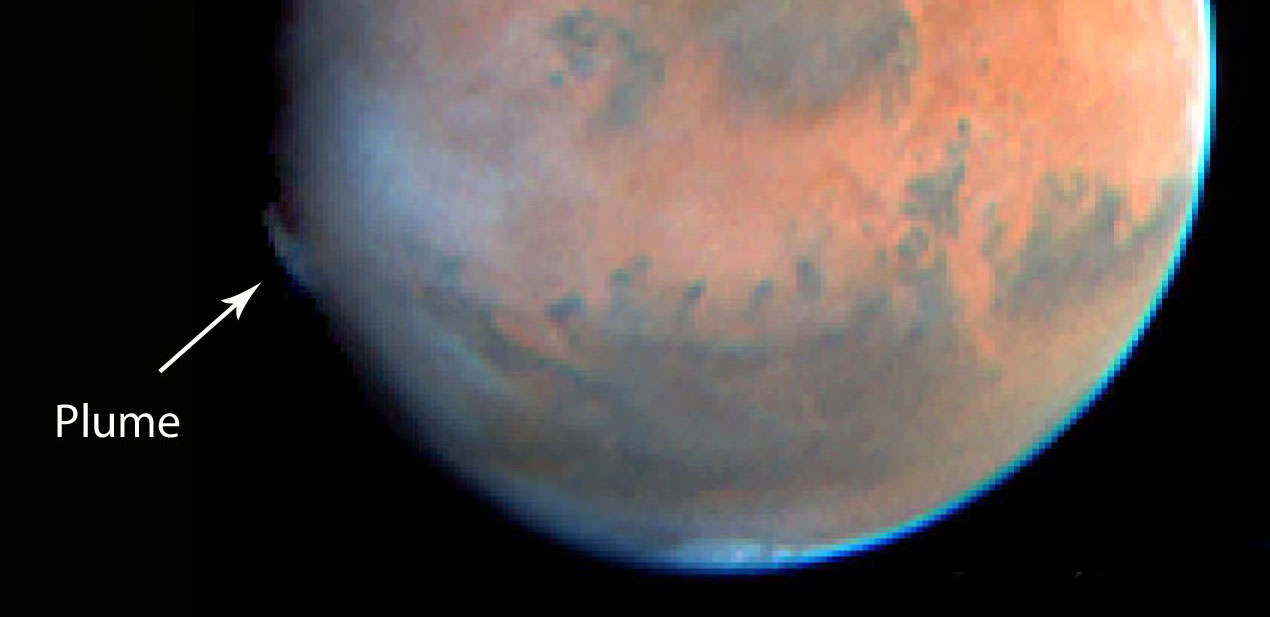
Hubble Space Telescope view of a plume high in the martian atmosphere seen in May 1997. Credit: NASA/ESA
A curious plume-like feature was observed on Mars on May 17, 1997 by the Hubble Space Telescope. It is similar to the features detected by amateur astronomers in 2012, although appeared in a different location. Credit: JPL/NASA/STScI
Strange plumes in Mars’ atmosphere first recorded by amateur astronomers four year ago have planetary scientists still scratching their heads. But new data from European Space Agency’s orbiting Mars Express points to coronal mass ejections from the Sun as the culprit.
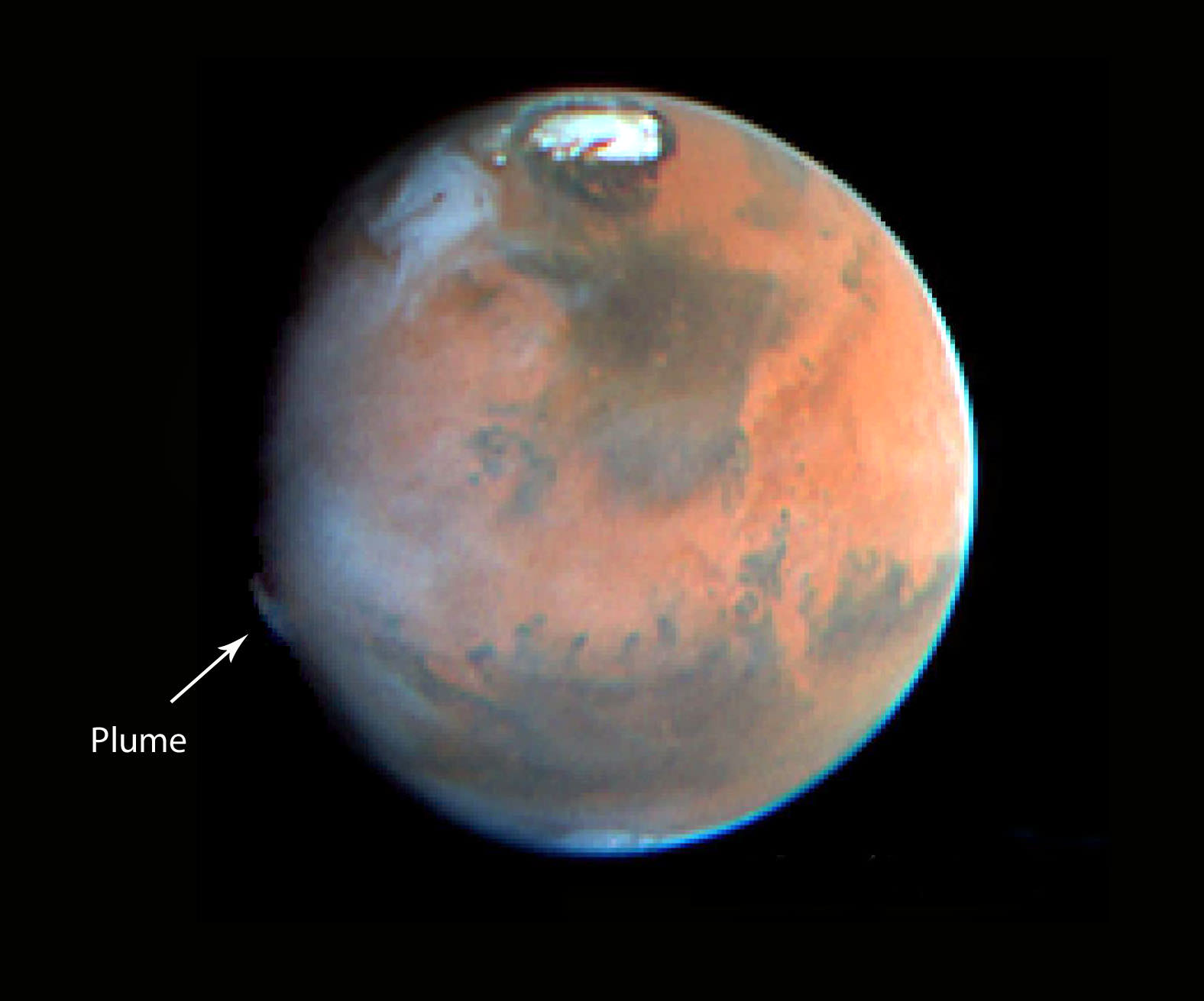
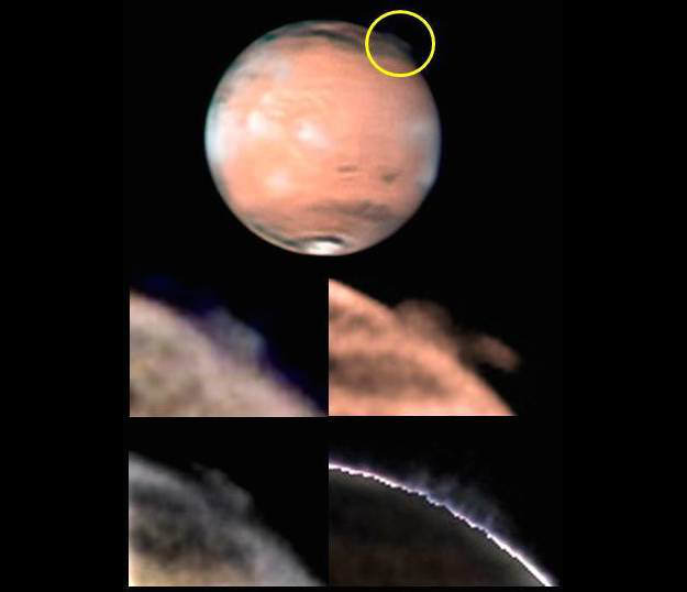
Mystery plume in Mars’ southern hemisphere photographed and animated by amateur astronomer Wayne Jaeschke on March 20, 2012. The feature lasted for about 10 days. Credit: Wayne Jaeschke
On two occasions in 2012 amateurs photographed cloud-like features rising to altitudes of over 155 miles (250 km) above the same region of Mars. By comparison, similar features seen in the past haven’t exceeded 62 miles (100 km). On March 20th of that year, the cloud developed in less than 10 hours, covered an area of up to 620 x 310 miles (1000 x 500 kilometers), and remained visible for around 10 days.
Back then astronomers hypothesized that ice crystals or even dust whirled high into the Martian atmosphere by seasonal winds might be the cause. However, the extreme altitude is far higher than where typical clouds of frozen carbon dioxide and water are thought to be able to form.
Indeed at those altitudes, we’ve entered Mars’ ionosphere, a rarified region where what air there is has been ionized by solar radiation. At Earth, charged particles from the Sun follow the planet’s global magnetic lines of force into the upper atmosphere to spark the aurora borealis. Might the strange features observed be Martian auroras linked to regions on the surface with stronger-than-usual magnetic fields?
Mars has magnetized rocks in its crust that create localized, patchy magnetic fields (left). In the illustration at right, we see how those fields extend into space above the rocks. At their tops, auroras can form. Credit: NASA
Once upon a very long time ago, Mars may have had a global magnetic field generated by electrical currents in a liquid iron-nickel core much like the Earth’s does today. In the current era, the Red Planet has only residual fields centered over regions of magnetic rocks in its crust.
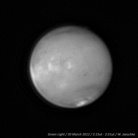
The top image shows the location of the mysterious plume on Mars, identified within the yellow circle (top image, south is up), along with different views of the changing plume morphology on March 21, 2012. Copyright: W. Jaeschke and D. Parker
Instead of a single, planet-wide field that funnels particles from the Sun into the atmosphere to generate auroras, Mars is peppered with pockets of magnetism, each potentially capable of connecting with the wind of particles from the Sun to spark a modest display of the “northern lights.” Auroras were first discovered on Mars in 2004 by the Mars Express orbiter, but they’re faint compared to the plumes, which were too bright to be considered auroras.
Still, this was a step in the right direction. What was needed was some hard data of a possible Sun-Earth interaction which scientists ultimately found when they looked into plasma and solar wind measurements collected by Mars Express at the time. David Andrews of the Swedish Institute of Space Physics, lead author of a recent paper reporting the Mars Express results, found evidence for a large coronal mass ejection or CME from the Sun striking the martian atmosphere in the right place and at around the right time.
Earth-based observations of the plume on March 21, 2012 (top right) and of Mars Express solar wind observations during March and April 2012 (bottom right). The left-hand graphics show Mars as seen by Mars Express. Green represents the planet’s dayside and gray, the nightside. Magnetic areas of the crust are shown in blue and red. The white box indicates the area in which the plume observations were made. Together, these graphics show that the amateur observations were made during the martian daytime, along the dawn terminator, while the spacecraft observations were made along the dusk terminator, approximately half a martian ‘day’ later.The black line on Mars is the ground track of the Mars Express orbiter. The plot on the lower right shows Mars Express’s solar wind measurements. The peaks marked by the horizontal blue line indicate the increase in the solar wind properties as a result of the impact of the coronal mass ejection. Credit: Copyright: visual images: D. Parker (large Mars image and bottom inset) & W. Jaeschke (top inset). All other graphics courtesy D. Andrews
CMEs are enormous explosions of hot solar plasma — a soup of electrons and protons — entwined with magnetic fields that blast off the Sun and can touch off geomagnetic storms and auroras when they encounter the Earth and other planets.
“Our plasma observations tell us that there was a space weather event large enough to impact Mars and increase the escape of plasma from the planet’s atmosphere,” said Andrews. Indeed, the plume was seen along the day–night boundary, over a region of known strong crustal magnetic fields.
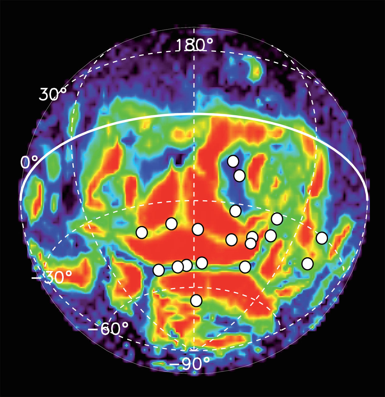
Locations of 19 auroral detections (white circles) made by Mars Express during 113 nightside orbits between 2004 and 2014, over locations already known to be associated with residual crustal magnetism. The data is superimposed on the magnetic field line structure (from NASA’s Mars Global Surveyor) where red indicates closed magnetic field lines, grading through yellow, green and blue to open field lines in purple. The auroral emissions are very short-lived, they are not seen to repeat in the same locations. Credit: ESA / Copyright Based on data from J-C. Gérard et al (2015)
But again, a Mars aurora wouldn’t be expected to shine so brightly. That’s why Andrews thinks that the CME prompted a disturbance in the ionosphere large enough to affect dust and ice grains below:
“One idea is that a fast-traveling CME causes a significant perturbation in the ionosphere resulting in dust and ice grains residing at high altitudes in the upper atmosphere being pushed around by the ionospheric plasma and magnetic fields, and then lofted to even higher altitudes by electrical charging,” according to Andrews.
A colossal CME, composed of a magnetized cloud of subatomic particles, departs the Sun in February 2000. Credit NASA/ESA/SOHO
With enough dust and ice twinkling high above the planet’s surface, it might be possible for observers on Earth to see the result as a wispy plume of light. Plumes appear to be rare on Mars as a search through the archives has revealed. The only other, seen by the Hubble Space Telescope in May 1997, occurred when a CME was hitting the Earth at the same time. Unfortunately, there’s no information from Mars orbiters at the time about its effect on that planet.
Observers on Earth and orbiters zipping around the Red Planet continue to monitor Mars for recurrences. Scientists also plan to use the webcam on Mars Express for more frequent coverage. Like a dog with a bone, once scientists get a bite on a tasty mystery, they won’t be letting go anytime soon.
Scene from ‘The Martian’ starring Matt Damon as NASA astronaut Mark Watney contemplating magnificent panoramic vista while stranded alone on Mars. Credits: 20th Century Fox
Scene from ‘The Martian’ starring Matt Damon as NASA astronaut Mark Watney contemplating magnificent panoramic vista while stranded alone on Mars.
Credits: 20th Century Fox
See real Martian maps and flyover video from DLR and NSA below
Story/imagery updated[/caption]
Go now and experience Hollywood’s blockbuster new space epic ‘The Martian’ helmed by world renowned director Ridley Scott and starring Matt Damon as the protagonist, NASA astronaut Mark Watney. And you can follow Watney’s dramatic fictional path across the Red Planet in newly released real photos and a flyover video of the region, from DLR and NASA, as it looks today.
‘The Martian’ is a mesmerizingly enjoyable cinematic triumph for everyone that’s all about science, space exploration and one man’s struggle to survive while left totally isolated on the Red Planet in the face of seemingly insurmountable odds – relying on his wits alone to endure “on a planet where nothing grows” while hoping somehow for a rescue by NASA four years in the future.
The movie combines compelling and plausible storytelling with outstanding special effects that’s clearly delighting huge audiences worldwide with a positive and uplifting view of what could be achieved in the future – if only we really put our minds to it!
Based on the bestselling book by Andy Weir, ‘The Martian’ movie from 20th Century Fox tells the spellbinding story of how NASA astronaut Mark Watney is accidentally stranded on the surface of Mars during the future Ares 3 manned expedition in 2035, after a sudden and unexpectedly fierce dust storm forces the rest of the six person crew – commanded by Jessica Chastain as Commander Lewis – to quickly evacuate after they believe he is dead.
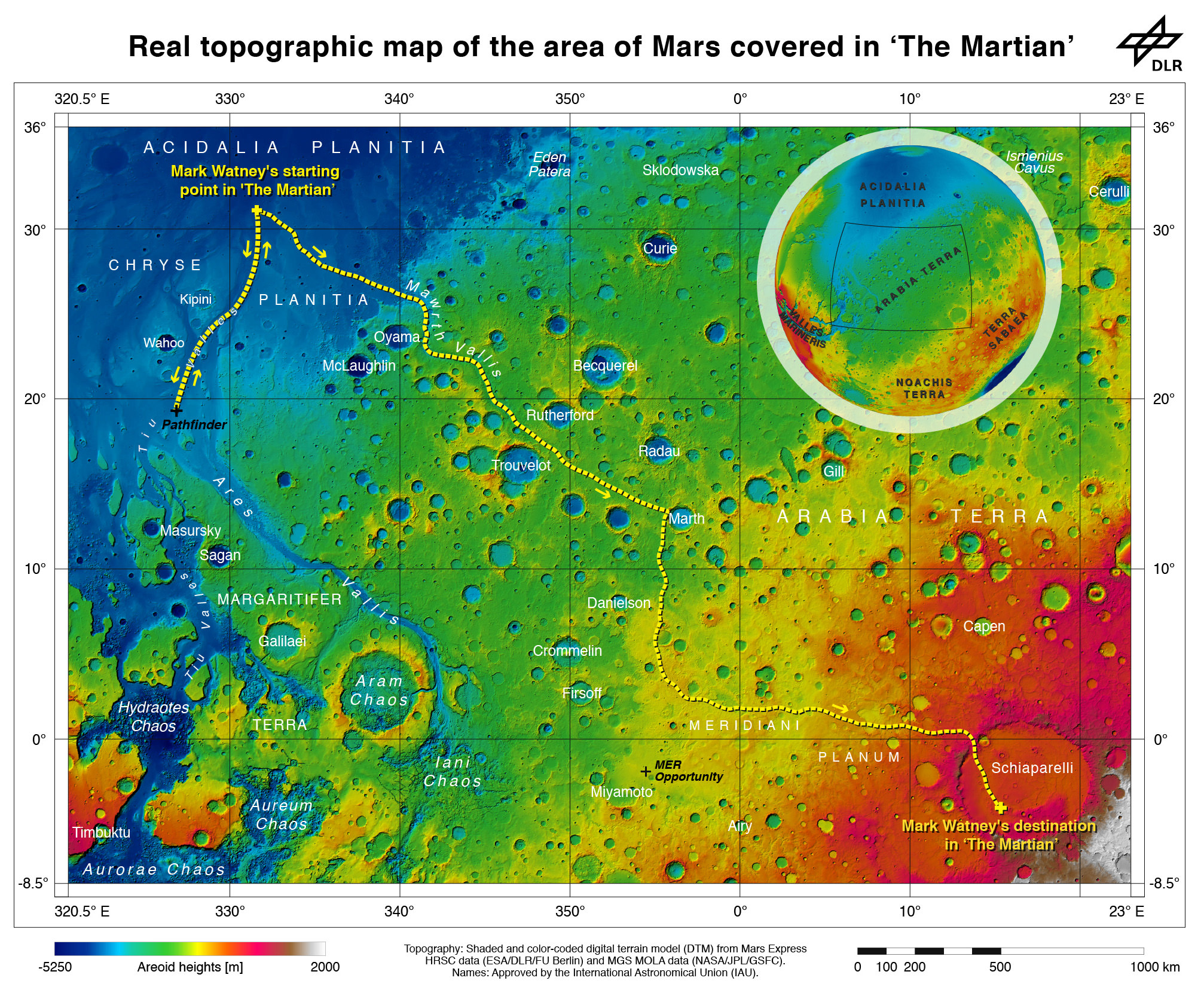
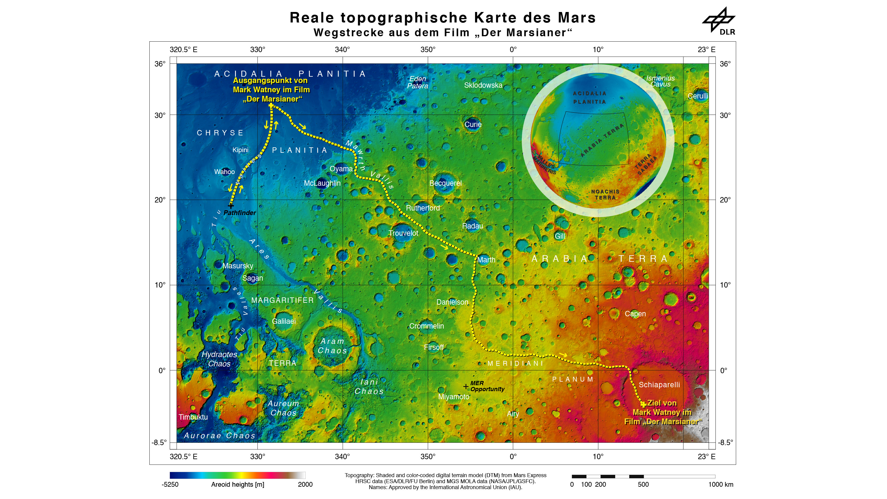
Real topographic map of the area of Mars covered in ‘The Martian.’ Follow the path of Mark Watney’s fictional endeavors from the Ares 3 landing site at Acidalia Planitia to NASA’s real Mars Pathfinder lander at the mouths of Ares Vallis and Tiu Valles and back, and finally to the Ares 4 landing site at Schiaparelli Crater. Credit: DLR/ESA/NASA
Now you can follow the fictional exploits of Mark Watney’s stunningly beautiful trail across the real Mars through a set of newly released maps, imagery and a 3D video created by the DLR, the German Aerospace Agency, and NASA – and based on photos taken by the European Space Agency’s Mars Express orbiter and NASA’s Mars Reconnaissance Orbiter (MRO).
DLR’s stunning 3D overflight video sequence was created from a dataset of 7300 stereo images covering roughly two-and-a-half million square kilometres of precisely mapped Martian landscape captured over the past 12 years by Mars Express High Resolution Stereo Camera (HRSC). The electric score is by Stephan Elgner.
Video Caption: Following the path of The Martian – video generated using images acquired by the Mars Express orbiter. Scientists from German Aerospace Center, DLR– who specialise in producing highly accurate topographical maps of Mars – reconstructed Watney’s route using stereo image data acquired by the High Resolution Stereo Camera on board European Space Agency’s #MarsExpress spacecraft. They then compiled this data into a video that shows the spectacular landscape that the protagonist would see ‘in the future’ on his trek from Ares 3 at Acidalia Planitia/Chryse Planitia to Ares 4 at Schiaparelli Crater. Credit: DLR/ESA
Ridley Scotts ‘The Martian’ takes place mostly on the surface of the Red Planet and is chock full of breathtakingly beautiful panoramic vistas. In the book you can only imagine Mars. In the movie Scott’s talents shine as he immerses you in all the action on the alien world of Mars from the opening scene.
Starting with the landing site for Watney’s Ares 3 mission crew at Acidalia Planitia, the book and movie follows his triumphs and tribulations, failures and successes as he logically solves one challenging problem after another – only to face increasingly daunting and unexpected hurdles as time goes by and supplies run low.
The DLR route map shows a real topographic view of Watney’s initial journey back and forth from the fictional Ares 3 landing site to the actual landing site of NASA’s 1997 Mars Pathfinder lander and Sojourner rover mission at the mouth of Ares Vallis.
Mark Watney arrives at the NASA’s 1997 Pathfinder lander to gather communications gear in a scene from “The Martian.” People and technology from NASA’s Jet Propulsion Laboratory aid fictional astronaut Mark Watney during his epic survival story in “The Martian.” Credits: 20th Century Fox
The map continues with Watney’s months-long epic trek to the fictional landing site of Ares 4 Mars Ascent Vehicle (MAV) spacecraft at Schiaparelli Crater, by way of Marth Valles and other Martian landmarks, craters and valleys.
At the request of Andy Weir, the HiRISE camera on NASA’s MRO orbiter took photos of the Martian plain at the Ares 3 landing site in Acidalia Planitia, which is within driving distance from the Pathfinder lander and Sojourner rover in the book and movie.
This May 2015 image from the HiRISE camera on NASA’s Mars Reconnaissance Orbiter shows a location on Mars associated with the best-selling novel and Hollywood movie, “The Martian.” It is in a region called Acidalia Planitia, at the landing site for the science-fiction tale’s Ares 3 mission. For the story’s central character, Acidalia Planitia is within driving distance from where NASA’s Mars Pathfinder, with its Sojourner rover, landed in 1997. Credits: NASA/JPL-Caltech/Univ. of Arizona
The Martian is all about how Watney uses his botany, chemistry and engineering skills to “Science the sh** out of it” to grow food and survive until the hoped for NASA rescue.
Learning how to live off the land will be a key hurdle towards enabling NASA’s real strategy for long term space voyages on a ‘Journey to Mars’ and back.
‘The Martian’ is a must see movie that broadly appeals to space enthusiasts and general audiences alike who can easily identify with Watney’s ingenuity and will to live.
Since its worldwide premiere on Oct. 2, ‘The Martian’ has skyrocketed to the top of the US box office for the second weekend in a row, hauling in some $37.3 million. The total domestic box office receipts now top $108 million and rockets to over $228 million worldwide in the first 10 days alone.
I absolutely loved ‘The Martian’ when I first saw the movie on opening weekend. And enjoyed it even more the second time, when I could pick up a few details I missed the first time around.
Matt Damon stars as NASA astronaut Mark Watney in ‘The Martian.’ Credit: 20th Century Fox
The movie begins as the crew evacuates after they believe Watney was killed by the dust storm. Watney actually survived the storm but lost contact with NASA. The film recounts his ingenious years long struggle to survive, figure out how to tell NASA he is alive and send a rescue crew before he starves to death on a planet where nothing grows. Watney’s predicament is a survival lesson to all including NASA.
‘The Martian’ was written by Andy Weir in 2010 and the film could well break the October movie box office record currently held by ‘Gravity.’
The movie closely follows the book, which I highly recommend you read at some point.
By necessity, the 2 hour 20 minute movie cannot capture every event in the book. So there is an abbreviated sense of Watney’s detailed science to survive and lengthy overland trips.
All the heroics and difficulties in traveling to Pathfinder and back and getting communications started, as well as the final month’s long journey to Schiaparelli crater are significantly condensed, but captured in spirit.
The Martian is brilliant and intelligent and rivals Stanley Kubrik’s space epic ‘2001: A Space Odyssey’ as one of the top movies about humanities space exploration quest.
The one big science inaccuracy takes place right at the start with the violent Martian dust storm.
On Mars the atmosphere is so thin that the winds would not be anywhere near as powerful or destructive as portrayed. This is acknowledged by Weir and done for dramatic license. We can look past that since the remainder of the tale portrays a rather realistic architectural path to Mars and vision of how scientists and engineers think. Plus the dust storms can in fact kick up tremendous amounts of particles that significantly block sunlight from impinging on solar energy generating panels.
Personally I can’t wait for the ‘Directors Cut’ with an added 30 to 60 minutes of scenes that were clearly filmed – but not included in the original theatrical release.
THE MARTIAN features a star studded cast that includes Matt Damon, Jessica Chastain, Kristen Wiig, Kate Mara, Michael Pena, Jeff Daniels, Chiwetel Ejiofor, and Donald Glover.
“NASA has endorsed “The Martian’” Jim Green, NASA’s Director of Planetary Sciences, told Universe Today. Green served as technical consultant on the film.
At NASA’s Kennedy Space Center in Florida agency scientists, astronauts actors from the 20th Century Fox Entertainment film “The Martian” met the media. Participants included, from the left, Center Director Bob Cabana, NASA’s Planetary Science Division Director Jim Green, Ph.D., actress Mackenzie Davis, who portrays Mindy Park in the movie, retired NASA astronaut Nicole Stott and actor Chiwetel Ejiofor, who portrays Vincent Kapoor in “The Martian.” Credit: Julian Leek
The DLR film was created by a team led by Ralf Jaumann from the DLR Institute of Planetary Research, Principal Investigator for HRSC. He believes that producing the overflight video was not just a gimmick for a science fiction film:
“Mars generates immense fascination, and our curiosity continues to grow! Many people are interested in our research, and young people in particular want to know what it is really like up there, and how realistic the idea that one day people will leave their footprints on the surface of Mars truly is. The data acquired by HRSC shows Mars with a clarity and detail unmatched by any other experiment. Only images acquired directly on the surface, for instance by rovers like Curiosity, are even closer to reality, but they can only show a small part of the planet. Thanks to this animation, we have even noticed a few new details that we had not seen in a larger spatial context. That is why we made the film – it helps everyone see what it would be like for Watney to travel through these areas… the clouds were the only creative touches we added, because, fortunately, they do not appear in the HRSC data,” according to a DLR statement.
Here’s the second official trailer for The Martian:
As a scientist and just plain Earthling, my most fervent hope is that ‘The Martian’ will inspire our young people to get interested in all fields of science, math and engineering and get motivated to become the next generation of explorers – here on Earth and beyond to the High Frontier to benefit all Mankind.
Stay tuned here for Ken’s continuing Earth and planetary science and human spaceflight news.
We can only imagine what the meteor storm from Comet Siding Spring must have looked like standing on the surface of Mars on October 19, 2014. NASA scientists announced today that the planet experienced an exceptional shower during the comet's flyby, saturating the sky. Source: Stellarium
“Thousands of meteors per hour would have been visible — truly astounding to the human eye.” That’s Nick Schneider’s description of what you and I would have seen standing on Mars during Comet Siding Spring’s close flyby last month. “It would have been really mind-blowing,” he added. Schneider is instrument lead for MAVEN’s Imaging Ultraviolet Spectrograph (IUVS).
He and a group of scientists who work as lead investigators for instruments on the MAVEN and Mars Reconnaissance Orbiter (MRO) spacecraft shared the latest results from the comet flyby during a media teleconference earlier today. There were many surprises. Would we expect anything less from a comet?
Here’s a summary of the results:
A very dusty ice ball – The comet’s dust tail and the amount of dust in its coma were much larger than expected, prompting Jim Green, director of NASA’s Planetary Science Division in Washington, to remark: “It makes me very happy we hid them (the spacecraft) on the backside of Mars. That really saved them.” Siding Spring dumped several tons of fine dust into the Martian atmosphere prompting a spectacular meteor shower and possibly causing a yellow, twilight afterglow above the Curiosity landing site from vaporizing sodium atoms contained in the minerals. That, and dust in the mid-levels of the atmosphere at the time contributed to the rover’s difficulty in getting good photos of the comet itself. Scientists are still examining the images.
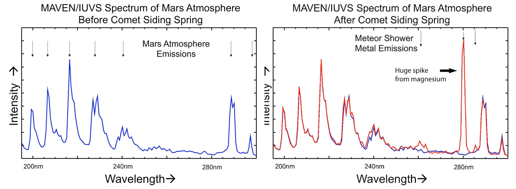
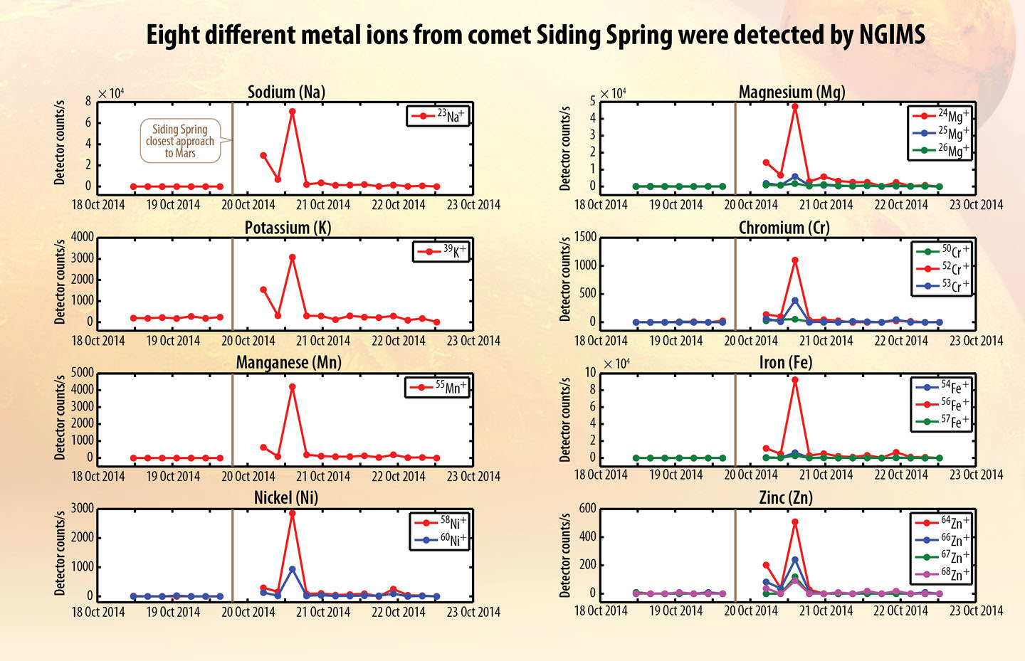
MAVEN’s Ultraviolet Imaging Spectrograph (IUVS) uses limb scans to map the chemical makeup and vertical structure across Mars’ upper atmosphere. It detected strong enhancements of magnesium and iron from ablating incandescing dust from Comet Siding Spring. Credit: NASAI’m not big into graphs either, but check out the heavy metal drama going on here. On the left is the “before” scan from MAVEN’s IUVS instrument; on the right, during the comet’s close approach. The spike in magnesium from vaporizing comet dust is impressive. Ionized magnesium is the strongest spike with neutral and ionized iron on the left in smaller amounts. Both elements are common in meteorites as well as on Earth. Credit: NASAProfiles showing spikes in the amounts of eight different metals over time detected in Mars’ atmosphere by MAVEN’s Neutral Gas and Ion Mass Spectrometer (NGIMS). The emissions faded within a short time, but chemicals from the comet will continue to interact with the Martian atmosphere over time. Credit: NASA
Chemistry of Mars’ atmosphere changed – Dust vaporized in the intense meteor shower produced a striking increase in the amount of magnesium, iron and others metals in Mars’ upper atmosphere. “We were pressed back in our chairs,” said Mike Schneider. The bombardment created a temporary new layer of comet-tainted air and may have acted as condensation nuclei for the formation of high-altitude clouds. MAVEN’s Neutral Gas and Ion Mass Spectrometer (NGIMS) recorded huge spikes in the levels of eight different metals during the comet’s passage and then trailed off a day or so later. “They came to MAVEN as a free sample from no less than an Oort Cloud comet,” said Mehdi Benna, instrument scientist for MAVEN’s Neutral Gas and Ion Mass Spectrometer.
The MARSIS instrument on the Mars Express is a ground penetrating radar sounder used to look for subsurface water and ice. It can also make soundings of the ionosphere. It was used to see the new ionospheric layer formed by vaporizing comet dust on October 19th. Credit: ESAThe Mars Express radar probed the ionosphere (upper atmosphere) at three different times. At top, before the comet arrived; middle, 7 hours later after the comet’s closest approach and bottom, hours later after the comet had departed. The middle graph shows a strong signal (blue horizontal bar) from the creation of a newly-ionized layer of the planet’s lower atmosphere from hot, fast-moving comet dust. Credit: ESA
Flaming comet dust creates new ionospheric layer – Comet dust slamming into the atmosphere at 125,000 mph (56 km/sec) knocked electrons loose from atoms in the thin Martian air 50-60 miles (80-100 km) high, ionizing them and creating a very dense ionization layer in the planet’s lower ionosphere seven hours after the comet’s closest approach. Normally, Mars ionosphere is only seen on the dayside of the planet, but even when the MARSIS instrumenton Mars Express beamed radio waves through the atmosphere on the nightside of the planet, it picked up a very strong signal.
54 red-filtered, false-color images of the comet’s nucleus-coma taken by the MRO’s HiRISE camera show changes in the flow of material leaving the comet. Based on the photos, the comet’s nucleus spins once every 8 hours. Credit: NASAThe five closest photos made with the HiRISE camera show the combined light of the nucleus and coma. Scale is 140-meter per pixel at top and 177-meters at bottom. Scientists will further process these images to separate the nucleus from the coma. Credit: NASA
Nucleus spins once during your work day – Comet Siding Spring’s icy core spins once every 8 hours and its irregular shape causes strong variations in the comet’s brightness. The comet’s size appears less certain – at least for the moment – with estimates anywhere between a few hundred meters to 2 km (1.2 miles). More analysis on images taken by MRO’s HiRISE camera should narrow that number soon.
CRISM photo and spectrum of Comet Siding Spring. The spectrum is “flat”, indicating we’re seeing ordinary sunlight reflecting off comet dust. The intriguing color variations in the image tell us the comet’s spewing dust particles of many sizes. Credit: NASA
Dust motes of many sizes – Color variations across Siding Spring’s coma seen by Compact Reconnaissance Imaging Spectrometer for Mars (CRISM) indicate it’s releasing dust particles of different sizes – big and little.
The scientists involved in the encounter couldn’t be happier with how the instruments functioned and the amount of hard data returned. Said Jim Green: “We are so lucky to observe this once-in-a-lifetime event.” How true when you consider that it takes about 8 million years for a comet from the Oort Cloud, that vast reservoir of frozen comets extending nearly a light year from the Sun, to get here in the first place. Nick Schneider put it another way:
“Not only is this a free sample of the Oort Cloud in Mars’ atmosphere, but it gives us a chance to learn more about Mars itself.”
If you’d like to listen in to the hour-long teleconference at any time, it’ll be up for the next week or so HERE.
Five orbiters from India, the European Union and the United States will nestle behind the Mars as comet Siding Springs passes at a speed of 200,000 km/hr (125,000 mph). At right, Comet Shoemaker-Levy 9 impacts on Jupiter, the Chelyabinsk Asteroid over Russia. (Credits: NASA,ESA, ISRO)
It was 20 years ago this past July when images of Jupiter being pummeled by a comet caught the world’s attention. Comet Shoemaker-Levy 9 had flown too close to Jupiter. It was captured by the giant planet’s gravity and torn into a string of beads. One by one the comet fragments impacted Jupiter — leaving blemishes on its atmosphere, each several times larger than Earth in size.
Until that event, no one had seen a comet impact a planet. Now, Mars will see a very close passage of the comet Siding Spring on October 19th. When the comet was first discovered, astronomers quickly realized that it was heading straight at Mars. In fact, it appeared it was going to be a bulls-eye hit — except for the margin of error in calculating a comet’s trajectory from 1 billion kilometers (620 million miles, 7 AU) away.
It took several months of analysis for a cataclysmic impact on Mars to be ruled out. So now today, Mars faces just a cosmic close shave. But this comet packs enough energy that an impact would have globally altered Mars’ surface and atmosphere.
So what should we Earthlings gather from this and other events like it? Are we next? Why or why not should we be prepared for impacts from these mile wide objects?
For one, ask any dinosaur and you will have your answer.
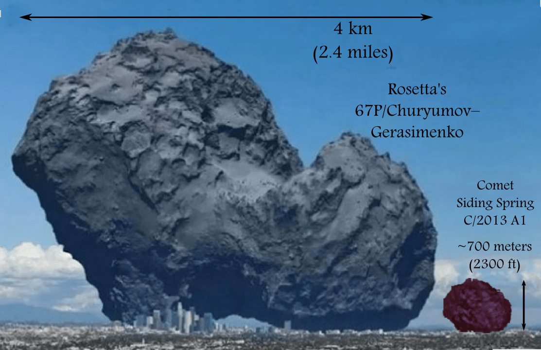
An illustration of the Siding Spring comet in comparison to the Comet 67P atop Los Angeles. The original image was the focus of Bob King’s article – “What Comets, Parking Lots and Charcoal Have in Common“. (Credit: ESA, anosmicovni)
One can say that Mars was spared as were the five orbiting spacecraft from India (Mars Orbiter Mission), the European Union (Mars Express) and the United States (MOD, MRO, MAVEN). We have Scottish-Australian astronomer Robert McNaught to thank for discovering the comet on January 3, 2013, using the half meter (20 inch) Uppsala Southern Schmidt Telescope at Siding Spring, Australia.
Initially the margin of error in the trajectory was large, but a series of observations gradually reduced the error. By late summer 2014, Mars was in the clear and astronomers could confidently say the comet would pass close but not impact. Furthermore, as observations accumulated — including estimates of the outpouring of gases and dust — comet Siding Spring shrunk in size, i.e. the estimates of potentially tens of kilometers were down to now 700 meters (4/10th of a mile) in diameter. Estimates of the gas and dust production are low and the size of the tail and coma — the spherical gas cloud surrounding the solid body — are small and only the outer edge of both will interact with Mars’ atmosphere.
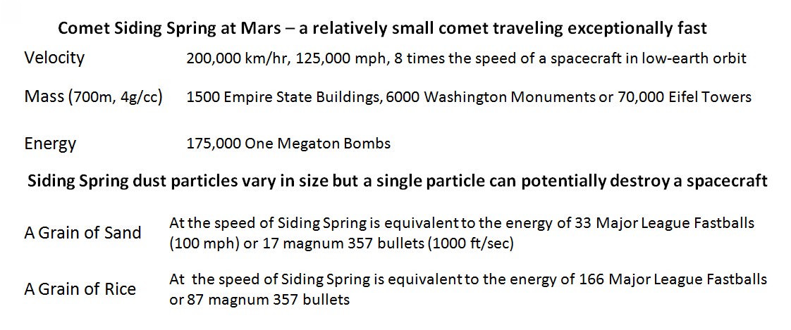
The mass, velocity and kinetic energy of celestial bodies can be deceiving. It is useful to compare the Siding Spring comet to common or man-made objects.
Yet, this is a close call for Mars. We could not rule out a collision for over six months. While this comet is small, it is moving relative to Mars at a speed of 200,000 kilometers/hour (125,000 mph, 56 km/sec). This small body packs a wallop. From high school science or intro college Physics, many of us know that the kinetic energy of an object increases by the square of the velocity. Double the velocity and the energy of the object goes up by 4, increase by 3 – energy increases by 9.
So the close shave for Mars is yet another wake up call for the “intelligent” space faring beings of the planet Earth. A wake up call because the close passage of a comet could have just as easily involved Earth. Astronomers would have warned the world of a comet heading straight for us, one that could wipe out 70% of all life as happened 65 million years ago to the dinosaurs. Replace dinosaur with humans and you have the full picture.
Time would have been of the essence. The space faring nations of the world — those of the EU, and Russia, the USA, Japan and others — would have gathered and attempted to conceive some spacecrafts with likely nuclear weapons that could be built and launched within a few months. Probably several vehicles with weapons would be launched at once, leaving Earth as soon as possible. Intercepting a comet or asteroid further out would give the impulse from the explosions more time to push the incoming body away from the Earth.
There is no way that humanity could sit on their collective hands and wait for astronomers to observe and measure for months until they could claim that it would just be a close call for Earth. We could imagine the panic it would cause. Recall the scenes from Carl Sagan’s movie Contact with people of every persuasion expressing at 120 decibels their hopes and fears. Even a small comet or asteroid, only a half kilometer – a third of a mile in diameter would be a cataclysmic event for Mars or Earth.
But yet, in the time that has since transpired from discovery of the comet Siding Spring (1/3/2013), the Chelyabinsk asteroid (~20 m/65 ft) exploded in an air burst that injured 1500 people in Russia. The telescope that discovered Comet Siding Spring was decommissioned in late 2013 and the Southern Near-Earth Object Survey was shutdown. This has left the southern skies without a dedicated telescope for finding near-Earth asteroids. And proposals such as the Sentinel project by the B612 Foundation remain underfunded.
We know of the dangers from small celestial bodies such as comets or asteroids. Government organizations in the United States and groups at the United Nations are discussing plans. There is plenty of time to find and protect the Earth but not necessarily time to waste.
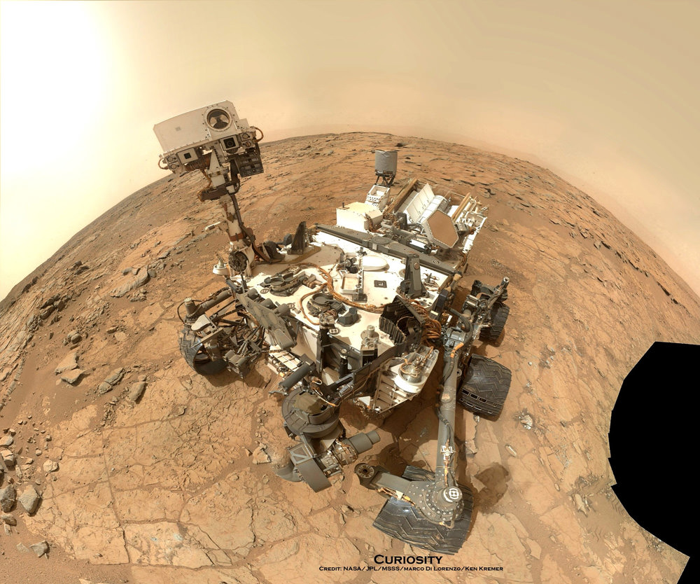
NASA's Mars rover Curiosity took this self-portrait, composed of more than 50 images using its robotic arm-mounted MAHLI camera, on Feb. 3, 2013. The image shows Curiosity at the John Klein drill site. A drill hole is visible at bottom left. Credit: NASA / JPL / MSSS / Marco Di Lorenzo / Ken Kremer- kenkremer.com
NASA’s planetary senior review panel harshly criticized the scientific return of the Curiosity rover in a report released yesterday (Sept. 3), saying the mission lacks focus and the team is taking actions that show they think the $2.5-billion mission is “too big to fail.”
While the review did recommend the mission receive more funding — along with the other six NASA extended planetary missions being scrutinized — members recommended making several changes to the mission. One of them would be reducing the distance that Curiosity drives in favor of doing more detailed investigations when it stops.
The role of the senior review, which is held every two years, is to help NASA decide what money should be allocated to its extended missions. This is important, because the agency (as with many other departments) has limited funds and tries to seek a balance between spending money on new missions and keeping older ones going strong.
Engineering acumen means that many missions are now operating well past their expiry dates, such as the Cassini orbiter at Saturn and the Opportunity rover on Mars. In examining the seven missions being reviewed, the panel did recommend keeping funding for all, but said that 4/7 are facing significant problems.
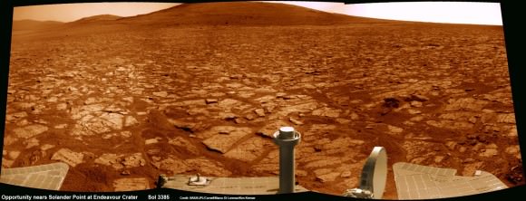
Opportunity rover’s 1st mountain climbing goal is dead ahead in this up close view of Solander Point at Endeavour Crater. Opportunity has ascended the mountain looking for clues indicative of a Martian habitable environment. This navcam panoramic mosaic was assembled from raw images taken on Sol 3385 (Aug 2, 2013). Credit: NASA/JPL/Cornell/Marco Di Lorenzo/Ken Kremer (kenkremer.com)
In the case of Curiosity, the panel called out principal investigator John Grotzinger for not showing up in person on two occasions, preferring instead to interact by phone. The review also said there is a “lack of science” in its extended mission proposal with regard to “scientific questions to be answered, testable hypotheses, and proposed measurements and assessment of uncertainties and limitations.”
Other concerns were the small number of samples over the prime and extended missions (13, a “poor science return”), and a lack of clarity on how the ChemCam and Mastcam instruments will play into the extended mission. Additionally, the panel expressed concern that NASA would cut short its observations of clays (which could help answer questions of habitability) in favor of heading to Mount Sharp, the mission’s ultimate science destination.
“In summary, the Curiosity … proposal lacked scientific focus and detail,” the panel concluded, adding in its general recommendations for the reviews that principal investigators must be present to avoid confusion while answering questions. The other missions facing concern from the panel included the Lunar Reconnaissance Orbiter, Mars Express and Mars Odyssey.
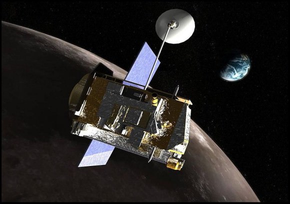
Lunar Reconnaissance Orbiter. Image Credit: NASA
LRO: Its extended mission (the second) is supposed to look at how the moon’s surface, subsurface and exosphere changes through processes such as meteorites and interaction with space. The panel was concerned with a “lack of detail” in the proposal and in answers to follow-up questions. The panel also recommended turning off certain instruments “at the end of their useful science mission”.
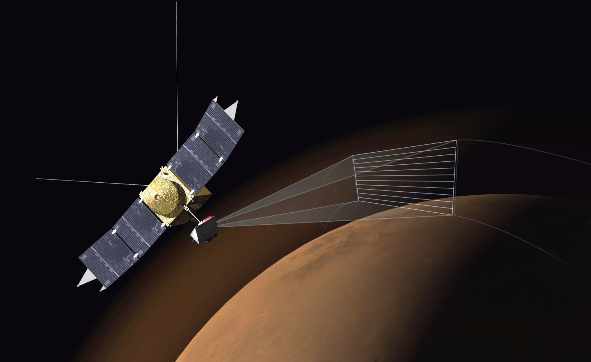
Mars Express: The extended mission is focusing on the ionosphere and atmosphere as well as the planet’s surface and subsurface. Concerns were raised about matters such as why funding is needed to calibrate its high-resolution stereo camera after 11 years — especially given the instrument has been rarely cited in published journal reports lately — and how people involved in the extended mission would meet the goals. The panel also saw a “lack of communication” in the team.
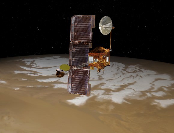
Mars Odyssey: If approved, the spacecraft will move to the day/night line of Mars to look at the planet’s radiation, gamma rays, distribution of water/carbon dioxide/dust in the atmosphere, and the planet’s surface. The panel, however, said there are no “convincing arguments” as to how the new science relates to the Decadal Survey objectives for planetary science. Odyssey, which is in its 11th year, may also be nearing the end of its productive lifespan given fewer publications using its data in recent years, the panel said.
The panel also weighed in on the success of the Cassini and Opportunity missions:
Artist’s conception of the Mars Odyssey spacecraft. Credit: NASA/JPL
Cassini received the highest rating — “Excellent” — due to its scientific merit, the only mission this time around to do so. The panel was particularly excited about seasonal changes that will be seen on Titan in the coming years, as well as measurements of Saturn’s rings and magnetosphere and its icier moons (such as Enceladus). The spacecraft is noted to be in good condition and the new mission will be a success because of “the unique aspect of the new observations.”
Opportunity, which is more than 10 years into its Mars exploration, is still “in sufficiently good condition” to do science, although the panel raised concerns about software and communication problems. The panel, however, said more time with the rover would allow it to look for evidence of past water on Mars that would not be visible from orbit — even though it’s unclear if phyllosilicates around its current location (Endeavour crater) are from the Noachian period, the earliest period in Mars’ history.
The panel is just one step along the road to figuring out how NASA chooses to spend its money in the coming years. Funding availability depends on how much money Congress allocates to the agency.
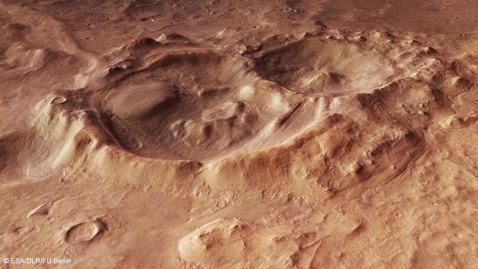
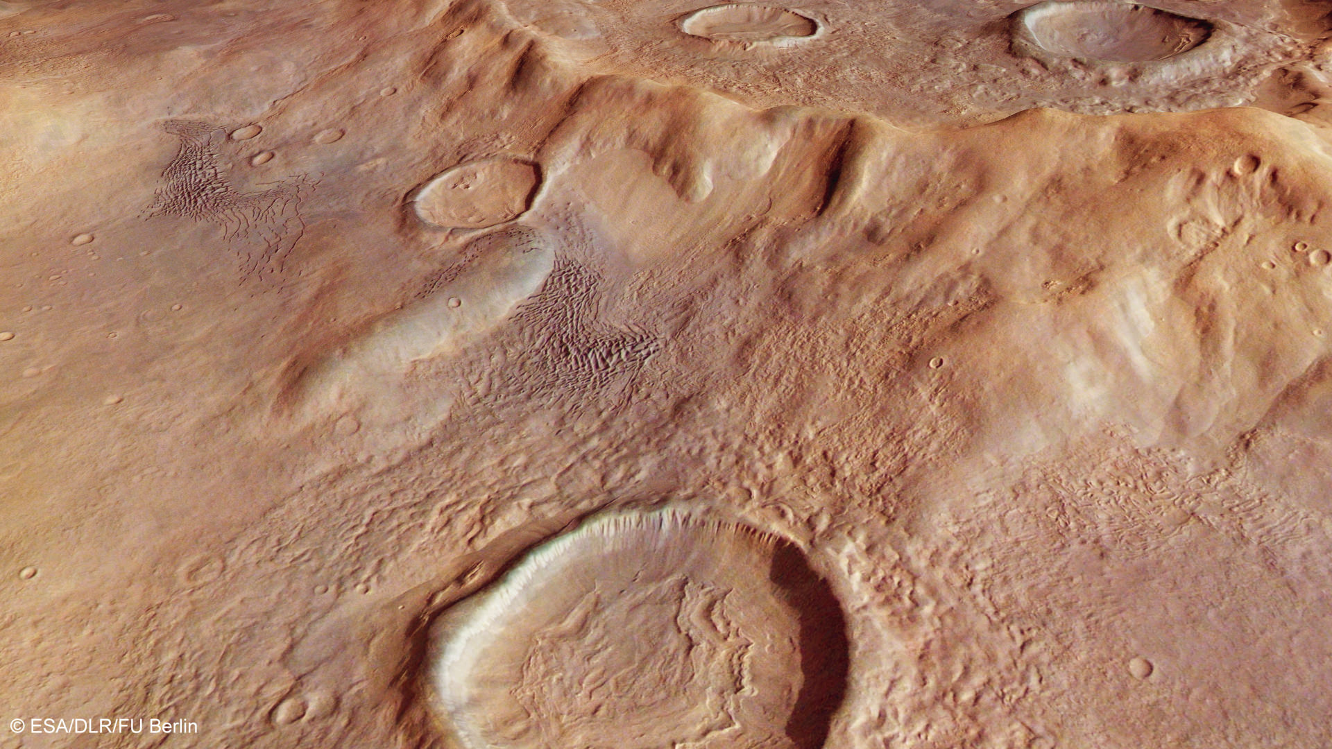
A Mars Express image of craters in Hellas Basin, an impact basin on Mars that is one of the biggest in the solar system. Credit: ESA/DLR/FU Berlin
Did that impact 4.1 billion years ago ever leave a scar! Here, a Mars Express photo from late 2013 (and just highlighted now) shows off craters in Hellas Basin, which was formed when the planets in our young Solar System were under intense bombardment from leftover remnants.
But over time, wind and erosion on Mars have changed the nature of this basin, the German Space Agency explained.
“Over time, the interior of Hellas Planitia has been greatly altered by geological processes,” the German Space Agency stated.
“The wind has blown dust into the basin, glaciers and streams have transported and deposited sediment, and volcanoes have built up layers of low-viscosity lava on the floor of Hellas. Despite its exposure to erosion and coverage by deposits for a long period of time, it is the best-preserved large impact basin on Mars.”
What’s more, Hellas is so deep (four kilometers or 2.5 miles) that scientists suspect water could be stable near the bottom of the pit. That’s because the combination of pressure and temperature there could possibly support water for some time, which is different from much of the rest of Mars where the pressure is too thin for water to do much but evaporate.
Perspective view of Hellas Basin taken with the High Resolution Stereo Camera on ESA’s Mars Express in January 2014, and released in July 2014. Credit: ESA/DLR/FU Berlin
Such great heights! A mountain chain peeks in the background of this new view of Hellas Basin, based on information taken by a European spacecraft circling the Red Planet.
Beyond the pretty picture is a tale of how snow behaved on the Martian surface, according to the European Space Agency. The vast basin is about half the size of Brazil.
The wrinkled view of that crater in front is a product of snowing and freezing that took place when the Martian surface was wetter, ESA said.
A map of the Hellas basin in the southern hemisphere of Mars, as well as the rocky Hellespontus Montes. Image taken by the High Resolution Stereo Camera on ESA’s Mars Express. Credit: NASA MGS MOLA Science Team/Freie Universitaet Berlin
“During this period, snow fell and covered the surface and later moved downhill into the crater. Once inside the crater, the snow became trapped and soon covered by surface dust, before compacting to form ice. The number of concentric lines indicates many cycles of this process and it is possible that craters like these may still be rich in ice hidden beneath just tens of metres of surface debris.”
Additionally, the high hill chain in the back (called Hellespontus Montes) is a remnant of how Hellas basin was formed, the agency said.
“This feature is a product of the final stages of the formation of the vast Hellas impact basin itself, most likely as the basin walls – which were first pushed outwards by the extraordinary forces at work during the formation of the basin – later collapsed and sank inwards to create the observed stair-stepped shape.”
The image was taken by ESA’s Mars Express spacecraft, which is just one of several robotic emissaries circling the Red Planet.
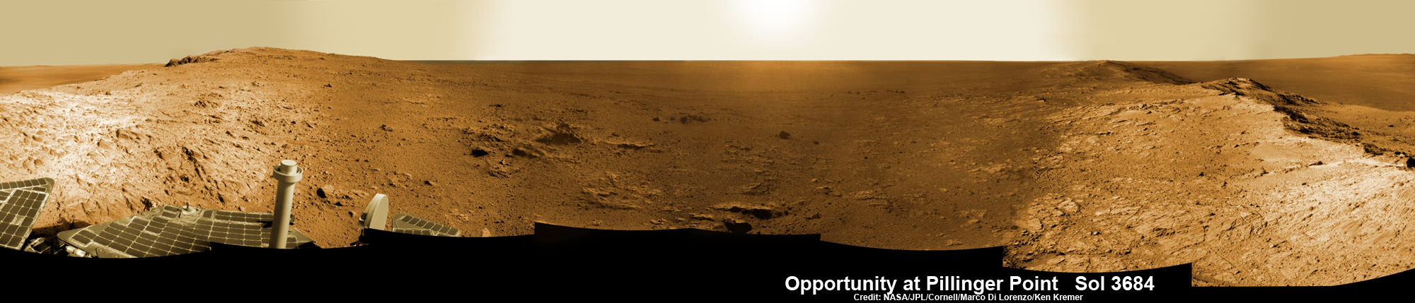
Opportunity Mars rover peers into vast Endeavour Crater from Pillinger Point mountain ridge named in honor of Colin Pillinger, the Principal Investigator for the British Beagle 2 lander built to search for life on Mars. Pillinger passed away from a brain hemorrhage on May 7, 2014. This navcam camera photo mosaic was assembled from images taken on June 5, 2014 (Sol 3684) and colorized. Credit: NASA/JPL/Cornell/Marco Di Lorenzo/Ken Kremer-kenkremer.com
NASA’s decade old Opportunity rover has reached a long sought after region of aluminum-rich clay mineral outcrops at a new Endeavour crater ridge now “named ‘Pillinger Point’ after Colin Pillinger the Principal Investigator for the [British] Beagle 2 Mars lander”, Prof. Ray Arvidson, Deputy Principal Investigator for the rover, told Universe Today exclusively. See above the spectacular panoramic view from ‘Pillinger Point’ – where ancient water once flowed billions of year ago.
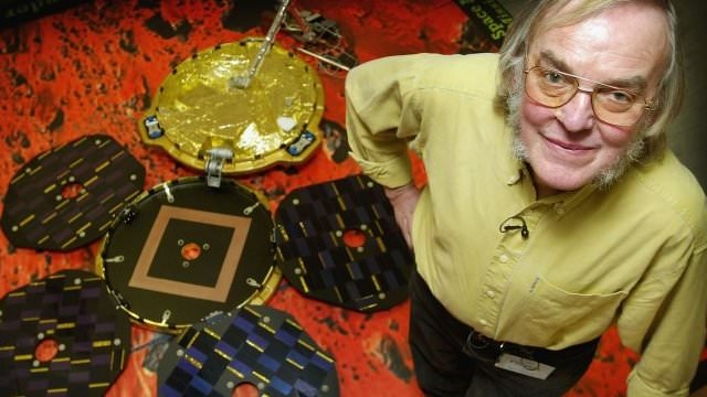
The Beagle 2 lander was built to search for signs of life on Mars.
The Mars Exploration Rover (MER) team named the noteworthy ridge in honor of Prof. Colin Pillinger – a British planetary scientist at the Open University in Milton Keynes, who passed away at the age of 70 on May 7, 2014.
‘Pillinger Point’ is a scientifically bountiful place possessing both clay mineral outcrops and mineral veins where “waters came up through the cracks”, Arvidson explained to me.
Since water is a prerequisite for life as we know it, this is a truly fitting tribute to name Opportunity’s current exploration site ‘Pillinger Point’ after Prof. Pillinger.
See our new photo mosaic above captured by Opportunity peering out from ‘Pillinger Point’ ridge on June 5, 2014 (Sol 3684) and showing a panoramic view around the eroded mountain ridge and into vast Endeavour crater.
The gigantic crater spans 14 miles (22 kilometers) in diameter.
See below our Opportunity 10 Year traverse map showing the location of Pillinger Point along the segmented rim of Endeavour crater.
British planetary scientist Colin Pillinger with the Beagle 2 lander.
Pillinger Point is situated south of Solander Point and Murray Ridge along the western rim of Endeavour in a region with caches of clay minerals indicative of an ancient Martian habitable zone.
For the past several months, the six wheeled robot has been trekking southwards from Solander towards the exposures of aluminum-rich clays – now named Pillinger Point- detected from orbit by the CRISM spectrometer aboard NASA’s powerful Martian ‘Spysat’ – the Mars Reconnaissance Orbiter (MRO) – while gathering context data at rock outcrops along the winding way.
“We are about 3/5 of the way along the outcrops that show an Al-OH [aluminum-hydroxl] montmorillonite [clay mineral] signature at 2.2 micrometers from CRISM along track oversampled data,” Arvidson told me.
“We have another ~160 meters to go before reaching a break in the outcrops and a broad valley.”
The rover mission scientists ultimate goal is travel even further south to ‘Cape Tribulation’ which holds a motherlode of the ‘phyllosilicate’ clay minerals based on extensive CRISM measurements accomplished earlier at Arvidson’s direction.
“The idea is to characterize the outcrops as we go and then once we reach the valley travel quickly to Cape Tribulation and the smectite valley, which is still ~2 km to the south of the present rover location,” Arvidson explained.
Mars Express and Beagle 2 were launched in 2003, the same year as NASA’s twin rovers Spirit and Opportunity, on their interplanetary voyages to help unlock the mysteries of Mars potential for supporting microbial life forms.
Pillinger was the driving force behind the British built Beagle 2 lander which flew to the Red Planet piggybacked on ESA’s Mars Express orbiter. Unfortunately Beagle 2 vanished without a trace after being deployed from the orbiter on Dec. 19, 2003 with an expected air bag assisted landing on Christmas Day, Dec. 25, 2003.
In an obituary by the BBC, Dr David Parker, the chief executive of the UK Space Agency, said that Prof. Pillinger had played a critical role in raising the profile of the British space programme and had inspired “young people to dream big dreams”.
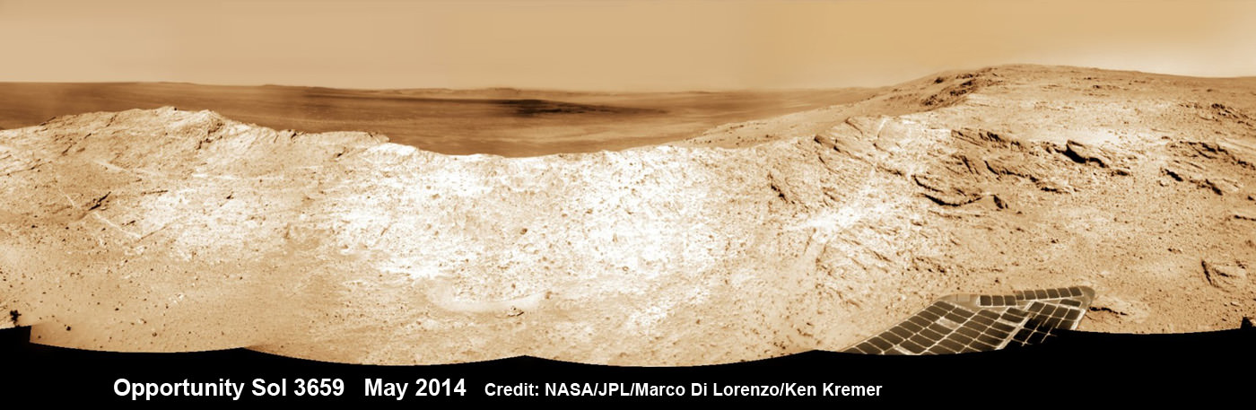
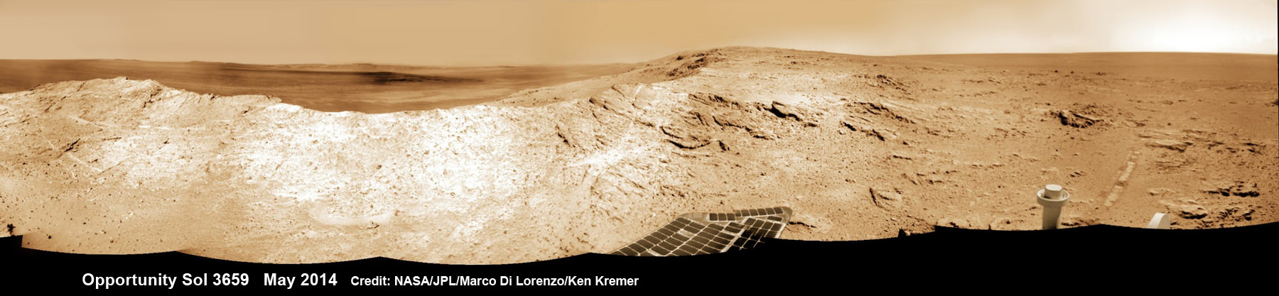
NASA’s Opportunity Mars rover captures sweeping panoramic vista near the ridgeline of 22 km (14 mi) wide Endeavour Crater’s western rim. The center is southeastward and also clearly shows the distant rim. See the complete panorama below. This navcam panorama was stitched from images taken on May 10, 2014 (Sol 3659) and colorized. Credit: NASA/JPL/Cornell/Marco Di Lorenzo/Ken Kremer-kenkremer.com
During his distinguished career Pillinger also analyzed lunar rock samples from NASA’s Apollo moon landing missions and worked on ESA’s Rosetta mission.
“It’s important to note that Colin’s contribution to planetary science goes back to working on Moon samples from Apollo, as well as his work on meteorites,” Dr Parker told the BBC.
Today, June 16, marks Opportunity’s 3696th Sol or Martian Day roving Mars – compared to a warranty of just 90 Sols.
So far she has snapped over 193,400 amazing images on the first overland expedition across the Red Planet.
Her total odometry stands at over 24.51 miles (39.44 kilometers) since touchdown on Jan. 24, 2004 at Meridiani Planum.
NASA’s Opportunity Mars rover captures sweeping panoramic vista near the ridgeline of 22 km (14 mi) wide Endeavour Crater’s western rim. The center is southeastward and the distant rim is visible in the center. An outcrop area targeted for the rover to study is at right of ridge. This navcam panorama was stitched from images taken on May 10, 2014 (Sol 3659) and colorized. Credit: NASA/JPL/Cornell/Marco Di Lorenzo/Ken Kremer-kenkremer.com
Meanwhile on the opposite side of Mars, Opportunity’s younger sister rover Curiosity is trekking towards gigantic Mount Sharp after drilling into her 3rd Red Planet rock at Kimberley.
Stay tuned here for Ken’s continuing Curiosity, Opportunity, Orion, SpaceX, Boeing, Orbital Sciences, MAVEN, MOM, Mars and more planetary and human spaceflight news.
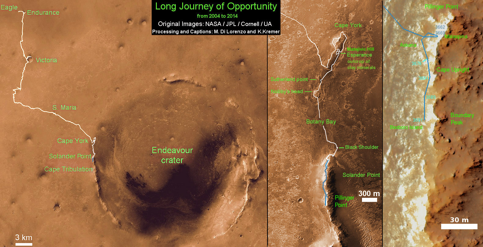
Traverse Map for NASA’s Opportunity rover from 2004 to 2014 – A Decade on Mars
This map shows the entire path the rover has driven during a decade on Mars and over 3692 Sols, or Martian days, since landing inside Eagle Crater on Jan 24, 2004 to current location along Pillinger Point ridge south of Solander Point summit at the western rim of Endeavour Crater and heading to clay minerals at Cape Tribulation. Opportunity discovered clay minerals at Esperance – indicative of a habitable zone. Credit: NASA/JPL/Cornell/ASU/Marco Di Lorenzo/Ken Kremer
A December 2013 image of Osuga Valles taken by the European Space Agency's Mars Express spacecraft, highlighted by the agency in April 2014. Credit: ESA/DLR/FU Berlin
This picture is an example of why Martian scientists like to get their groove on. This late 2013 snapshot of Osuga Valles — a part of the vast Valles Marineris gorge that cuts across the Red Planet — shows the leftovers of an ancient flood. The European Space Agency highlighted the area in a release this week.
“Catastrophic flooding is thought to have created the heavily eroded Osuga Valles and the features within it. Streamlines around the islands in the valley indicate that the direction of flow was towards the northeast … and sets of parallel, narrow grooves on the floor of the channel suggest that the water was fast flowing,” the European Space Agency stated.
“Differences in elevation within the feature, along with the presence and cross-cutting relationships of channels carved onto the islands, suggest that Osuga Valles experienced several episodes of flooding.”
Things get even more interesting when you look a bit closer up, as you can see below.
A close-up view of Osuga Valles created from data acquired with the Mars Express’ High Resolution Stereo Camera. Water flowed towards the top of this image. Credit: ESA/DLR/FU Berlin
“The grooved nature of the valley floor suggests the water was fast flowing, carving out the features as it flooded the region,” ESA added. “The elevated ‘island’ blocks are also carved with small channels, recording the history of previous flood episodes.”
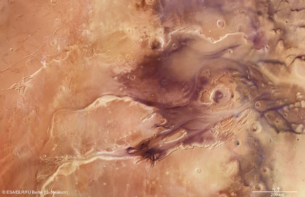
A mosaic of 67 images from the Mars Express spacecraft of Kasei Valles on Mars. Credit: ESA/DLR/FU (G. Neukum)
Over 3 billion years ago, dramatic flood events likely carved this gigantic channel system on Mars. It extends some 3,000 km and covers over 1.55 million square kilometers. ESA released this flyover video today, on the 10th anniversary of the Mars Express spacecraft’s launch to the Red Planet on January 14, 2004.
ESA describes the scene in the video:
The scene spans 987 km in the north–south direction, 19–36°N, and 1550 km in the east–west direction (280–310°E). It covers 1.55 million square kilometers, an area equivalent to the size of Mongolia.
Kasei Valles splits into two main branches that hug a broad island of fractured terrain — Sacra Mensa — rising 2 km above the channels that swerve around it. While weaker materials succumbed to the erosive power of the fast-flowing water, this hardier outcrop has stood the test of time.
Slightly further downstream, the flood waters did their best to erase the 100 km-wide Sharonov crater, crumpling its walls to the south. Around Sharonov many small streamlined islands form teardrop shapes rising from the riverbed as water swept around these natural obstacles.