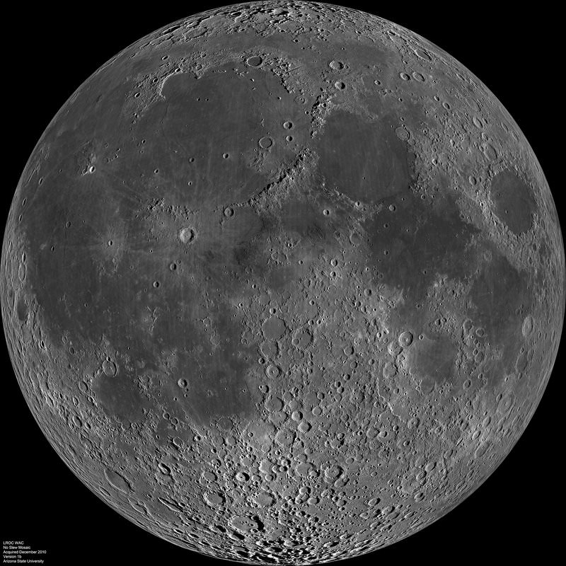
The Moon as You’ve Never Seen It Before

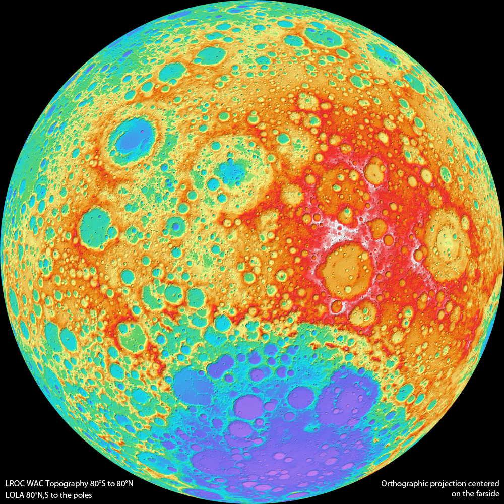
Lunar Reconnaissance Orbiter Wide Angle Camera color shaded relief of the lunar farside (NASA/GSFC/DLR/Arizona State University).

[/caption]

You’re looking at a brand new view of the lunar farside, as never seen before. The team from the Lunar Reconnaissance Orbiter has released the first version of a topographic map of nearly the entire Moon, from data from the Wide Angle Camera (WAC) on the spacecraft.

“This amazing map shows you the ups and downs over nearly the entire Moon, at a scale of 100 meters across the surface, and 20 meters or better vertically,” said principal investigator Mark Robinson, writing on the LROC website. “Despite the diminutive size of the WAC (it fits in the palm of one’s hand), it images nearly the entire Moon every month.”

Every month? So why is this a “new” map since LRO has been in lunar orbit since mid-2009?

Robinson said that each month the Moon’s lighting changes, so the WAC methodically builds up a record of how different rocks reflect light under different conditions, and adds to the LROC library of stereo observations.

“The WAC really is the little camera that could!” Robinson said.
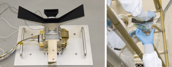
Left: LROC Wide Angle Camera attached to a test setup shortly before mounting on the spacecraft. Right: WAC being handed up to engineers for integration with LRO. Photos courtesy Mark Robinson, via the LROC website.

It is very similar to the MARCI camera (Mars Color Imager) on the Mars Reconnaissance Orbiter, another wide-angle, low-resolution camera specially built for orbital observations; both cameras were built by Malin Space Science Systems.

Topographic maps provide a detailed and accurate graphic representation of natural features on the ground, and Robinson this new map of the Moon will help both lunar scientists and future explorers on the Moon.

Combing data from the WAC along with the LRO Lunar Orbiter Laser Altimeter (LOLA), the scientists are able to provide a topographic map of nearly the entire Moon. Due to persistent shadows near the poles it is not possible to create a complete WAC stereo map at the very highest latitudes, but LOLA provides a very high resolution topographic model of the poles.

How is a digital topographic map created from stereo images? The WAC stereo images were compared one against another by pattern-matching a moving box of pixels until the best fit was found between two images with different viewing angles. The new topographic model was constructed from 69,000 WAC stereo models.

Robinson and his team are already looking towards improvements they can make with subsequent versions of their topographic maps.

“The current model incorporates the first year of stereo imaging, and there is another year of data that can be added to the solution,” he said. “These additional stereo images will not only improve the sharpness (resolution) of the model but also fill in very small gaps that exist in the current map. The LROC team has made small improvements to the camera distortion model, and the LOLA team has improved our knowledge of the spacecraft position over time. These next generation steps will further improve the accuracy of Version 2 of the LROC GLD100 topographic model of the Moon.”

You can see the “zoomable” full resolution versions of the new map for both the far and near side at this link.

Source: LROC website

LRO to Move in For Closer Look at the Apollo Landing Sites

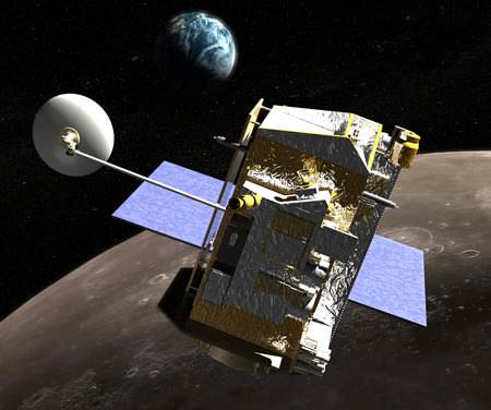
Artist concept of LRO in lunar orbit. Credit: NASA

[/caption]

NASA’s Lunar Reconnaissance Orbiter (LRO) is changing our view of the Moon by literally bringing it into sharper focus with its three high resolution cameras. But now, things are about to get even sharper. Today, LRO fired its thrusters to begin dipping down from its usual orbit about 50 km above the surface and moving to an orbit that will allow the spacecraft’s cameras me to image the Apollo sites from about 20 km away.

“This will allow me to obtain images of the Apollo sites that are about 4 times sharper than my current best images,” said the LRO spacecraft on Twitter.


This is just a temporary orbit and the spacecraft will take images of and around the Apollo sites between August 14 and 19, 2011. After that, the spacecraft will return to the 50-km-orbit until December.

LRO has two narrow angle cameras (NACs) and one wide angle camera (WAC).

According to Mark Robinson, LROC Principal Investigator, who spoke at the Lunar Forum at Ames Research Center last month, as of the end of July, 2011 the amount of data returned by LRO has been about 400 gigabits of data every day, which includes 371,027 high resolution images. The WAC has taken about 160,000 images, with about 90,000 in color. In total, the spacecraft has imaged the entire Moon about 20 times with the WAC, and has imaged 20 per cent of the moon with NACs, which provides a narrower but higher resolution view.

“We want to map the whole moon at 50 cm/pixel to 200 cm/pixel, and that would be LROC’s legacy for the next 100 years of lunar exploration and science,” Robinson said.

He noted that all three cameras are performing way better than he had hoped.

“We are very excited about the quality of the data,” Robinson said.

So get ready for a little more quality views of the Apollo landing sites!

Update: as commenter MoonOrBust noted, the LRO Twitter feed had an addendum later in the day, adding that there are several technical challenges associated with getting improved resolution images at the lower altitude orbit. For example, the spacecraft will not slow from its orbital speed of about 1.6 km/s (about 3,500 mph) when it gets closer to the Moon’s surface, which might cause some image blurring, particularly for the LROC Narrow Angle Camera images. “However, it will certainly be fun to compare the images from the different orbits!” the spacecraft Tweeted.

Look Inside a Lunar Crater

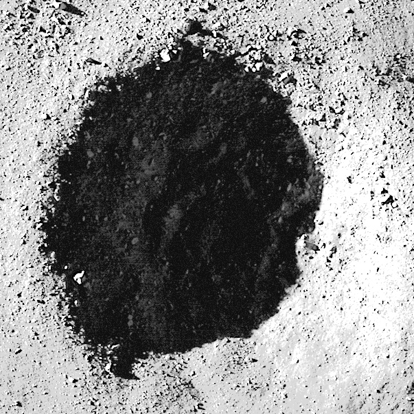
Brightening the shadowed area reveals details of the crater floor...and even more boulders!

[/caption]

The crater shown above is located in the lunar highlands and is filled with and surrounded by boulders of all sizes and shapes. It is approximately 550 meters (1800 feet) wide yet is still considered a small crater, and could have been caused by either a direct impact by a meteorite or by an ejected bit of material from another impact. Scientists studying the Moon attempt to figure out how small craters like this were formed by their shapes and the material seen around them…although sometimes the same results can be achieved by different events.

For example, when an object from space strikes the Moon, it is typically traveling around 20 km per second (12 miles/sec). If the impact site happens to have a very hard subsurface, it can make a crater with scattered bouldery chunks composed of the hard material around it. But, if a large piece of ejected material from another impact were to strike the lunar surface at a much slower speed, as ejecta typically do (since they travel slower than incoming space debris and the Moon’s escape velocity is fairly low, meaning any ejecta that does fall back to the surface must be traveling slower than 2.38 km/s,) then the ejected chunk could break apart on impact and scatter boulders of itself around the crater…regardless of subsurface composition.

Really the only way to tell for sure which scenario has taken place around a given crater – such as the one above – is to collect and return samples from the site so they can be tested. (Of course that’s much easier said than done!)

You can read more about this image on Arizona State University’s Lunar Reconnaissance Orbiter Camera site here.

And as an added treat, take a look deep into the shadows of the crater’s interior below…I tweaked the image curves in Photoshop to wrestle some of the details out of there!


Brightening the shadowed area reveals details of the crater floor...and even more boulders!

Image credit: NASA/GSFC/Arizona State University. (Edited by J. Major.)

P.S.: Want to see both image versions combined? Click here. (Thanks to Mike C. for the suggestion!)

Lunar Farside Gets Highest Resolution Look Yet from LRO

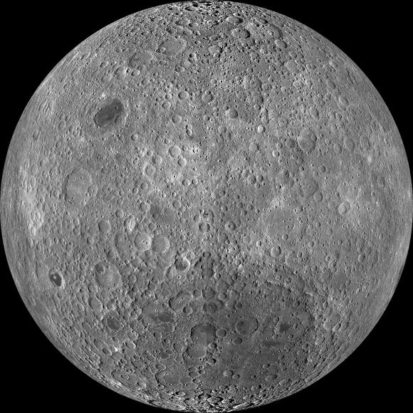
The lunar farside as never seen before! LROC WAC orthographic projection centered at 180° longitude, 0° latitude. Credit: NASA/GSFC/Arizona State University.

[/caption]

The first time humans were able to catch a glimpse of the far side of the Moon was back in 1959 when the Soviet Luna 3 spacecraft sent back 29 grainy images taken during its successful loop around the Moon. “What a surprise – the farside was a different world, geologically,” said Mark Robinson, principal investigator for the camera on board the Lunar Reconnaissance Orbiter. “Unlike the widespread maria on the nearside, basaltic volcanism was restricted to a relatively few, smaller regions on the farside, and the battered highlands crust dominated.”

Since then, just a handful of spacecraft have taken images of the far side of the Moon, but now, Robinson has had a hand in creating the most detailed view yet of the farside of the Moon. A mosaic of the far side released today is comprised of over 15,000 Wide Angle Camera images acquired between November 2009 and February 2011.


“This WAC mosaic provides the most complete look at the morphology of the farside to date, and will provide a valuable resource for the scientific community,” Robinson wrote on the LROC website. “And it’s simply a spectacular sight!”

And how!

Every month, as LRO circles the Moon, the WAC gathers images to provide nearly complete coverage of the Moon under unique lighting. This mosaic knits together images all with similar lighting. As an added bonus the orbit-to-orbit image overlap provides stereo coverage, and even more images will be released on March 15.

“As the mission progresses, and our knowledge of the lunar photometric function increases, improved and new mosaics will be released!” Robinson said. “Work your way around the Moon with these six orthographic projections constructed from WAC mosaics.”

Click here for more stunning, high resolution views of the Moon.

Source: LROC

The Moon Just Got Bigger

Lunar Reconnaissance Orbiter Wide Angle Camera mosaic of the lunar nearside. Credit: NASA/GSFC/Arizona State University.

[/caption]

Take a gander at this brand new image of the Moon from the Lunar Reconnaissance Orbiter, which is one of the largest and highest resolution images ever compiled of the near-side of the Moon. For two weeks in mid-December 2010, LRO’s orbit allowed the spacecraft to remain looking straight down. Gathering over 1,300 images during this time, LRO’s imaging run allowed the team to compile a monstrous 24,000 x 24,000 pixel mosaic from the Wide Angle Camera (WAC), with a resolution of approximately 145 meters per pixel. The detail is nothing short of spectacular.

You can go the LROC website and see a 1400 X 1400 version, another 1400 X 1400 version with labels, and the full version that you can “Zoomify” and see incredible detail like never before.

Source: LROC website.

An Unusual Look at the Moon’s South Pole

The Moon's south pole, as see by the Lunar Reconnaissance Orbier. Credit: NASA/GSFC/Arizona State University.

[/caption]

No, this is not a wheel of moldy Swiss Cheese. It’s an illumination map of the South Pole of the Moon. There are some areas on the poles of the Moon, particularly the interior of craters, that lie in permanent shadow while other areas remain sunlit for the majority of the year. This image was taken by the Lunar Reconnaissance Orbiter Camera, which has a primary objective of unambiguously identifying these regions. This composite image contains over 1,700 images taken of the same area by the LROC Wide Angle Camera (WAC) over a six month period, which works out to six lunar days.

Here’s how the LROC team described how they created the image:

“Each image was map projected and converted to a binary image (if the ground was illuminated that pixel was set to one, and if shadowed zero) to differentiate between sunlit and shadowed regions. All the binary images were then stacked, and then for each pixel it was determined what percentage of the time during six months that spot was illuminated. Presto – an illumination map! The LROC team is making daily (which is about 28 Earth days) and yearly illumination maps for both poles. Such maps will provide the foundation for planning future robotic and human missions to the poles.”

Anyone up for building a telescope inside one of those craters?

Source: LROC website