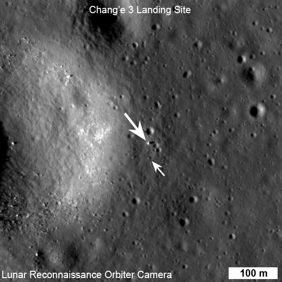
Image of Chang'e-3 (top arrow) and Yutu rover captured by NASA's Lunar Reconnaissance Orbiter on Dec. 25 UTC
Not much on the Moon escapes the eyes of NASA’s Lunar Reconnaissance Orbiter, and China’s Chang’e-3 lander and Yutu rover are no exception! The pair touched down on the lunar surface on Dec. 14, and just over a week later on Dec. 25 LRO acquired the image above, showing the lander and the 120-kg (265-lb) “Jade Rabbit” rover at their location near the Moon’s Sinus Iridum region.
The width of the narrow-angle camera image is 576 meters; north is up. LRO was about 150 km (93 miles) from the Chang’e-3 site when the image was acquired.
So how can we be so sure that those bright little specks are actually human-made robots and not just a couple of basaltic boulders? Find out below:
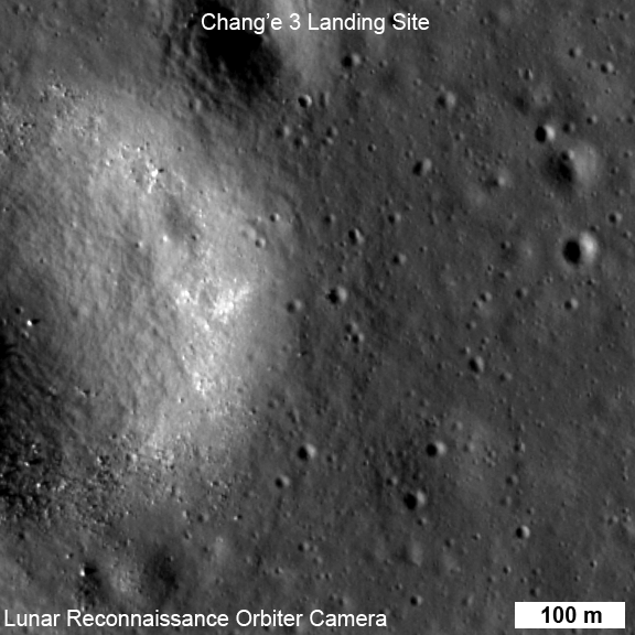
The rover is only about 150 cm wide, yet it shows up in the NAC images for two reasons: the solar panels are very effective at reflecting light so the rover shows up as two bright pixels, and the Sun is setting thus the rover casts a distinct shadow (as does the lander). Since the rover is close to the size of a pixel, how can we be sure we are seeing the rover and not a comparably sized boulder? Fortuitously, the NAC acquired a “before” image of the landing site, with nearly identical lighting, on 30 June 2013. By comparing the before and after landing site images, the LROC team confirmed the position of the lander and rover, and derived accurate map coordinates for the lander (44.1214°N, 340.4884°E, -2640 meters elevation).
Before-and-after LROC images of Chang’e-3’s landing site: June 30 vs. Dec. 25, 2013
LRO circles the Moon in a polar orbit at an average altitude of 50 km (31 miles). The LROC instrument contains two narrow-angle camera heads (NACs) providing 0.5-meter/pixel panchromatic images over a 5-km swath, a wide-angle camera head (WAC) providing images at a scale of 100 meters in seven-color bands.
Both the Chang’e-3 lander and Yutu rover are reported to be in good health and performing well. The solar-powered rover went into sleep mode on Dec. 26 to wait out the 14-day lunar night, during which time the temperatures on the lunar surface can drop to -180ºC (-292ºF). Yutu’s radioisotope heat source will keep it from freezing, but it won’t be able to generate power from its solar arrays. (Source)
Read more on ASU’s LROC website, and check out Ken Kremer’s article featuring a video of Yutu’s rollout here.
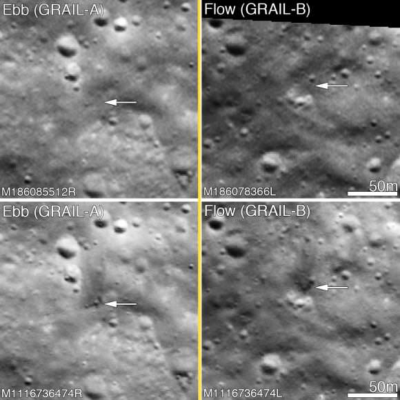
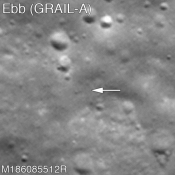
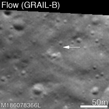
Before and after the GRAIL twins impacts on the Moon December 17, 2012. The LROC Narrow Angle Camera (NAC) directors were able to resolve the impact sites on February 28, 2013, revealing both to be about 5 meters in diameter. Upper panels show the area before the impact; lower panels after the impact. Arrows point to crater locations. LROC NAC observations M186085512R, M186078336L, M1116736474R and M1116736474L. Credit: NASA/GSFC/Arizona State University.
On December 17, 2012, the GRAIL mission came to an end, and the two washing machine-sized spacecraft performed a flying finale with a planned formation-flying double impact into the southern face of 2.5-kilometer- (1.5-mile-) tall mountain on a crater rim near the Moon’s north pole. The Lunar Reconnaissance Orbiter has now imaged the impact sites, which show evidence of the crashes.
But surprisingly, these impacts were not what was expected, says the LRO and GRAIL teams. The ejecta around both craters is dark. Usually, ejecta from craters is lighter in color – with a higher reflectance – than the regolith on surface.
“I expected the ejecta to be bright,” said LROC PI Mark Robinson at a press conference from the Lunar and Planetary Science Conference today, “because everybody knows impact rays on the Moon are bright. We are speculating it could be from hydrocarbons from the spacecraft.”
GRAIL A site seen before and after the impact event. Crater center is located at 75.609°N, 333.407°E/ Credit: NASA/GSFC/Arizona State University.
Typically ejecta from craters is brighter, since subsurface regolith tends to have a higher reflectance. The lunar regolith on the surface tends to be darker because of its exposure to the vacuum of space, cosmic radiation, solar wind bombardment, and micrometeorite impacts. Slowly over time, these processes tend to darken the surface soil.
Robinson said the hydrocarbons could have come from fuel left in the fuel lines (JPL estimated a quarter to half a kilogram of fuel may have remained in the spacecraft – so, not very much) or from the spacecraft itself, which is made out of carbon material.
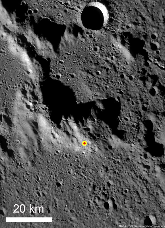
GRAIL B site seen before and after impact event. Crater center is located at 75.651°N, 333.168°E. Credit: NASA/GSFC/Arizona State University.
Additionally, the impact craters’ shapes were not as expected. The impacts formed craters about 5 m (15 ft) in diameter, and there is little ejecta to the south – the direction from which the spacecraft were traveling. “The spacecraft came in at a 1 or 2 degree impact angle,” said Robinson, “so this not a normal impact, as all the ejecta went upstream in the direction of travel.”
“I was expecting to see skid marks, myself,” said GRAIL principal investigator Maria Zuber. She added that she was committed to using every bit of fuel to mapping the gravity field at as low an altitude as possible. “I was determined that we would not end the mission with unused fuel because that would have meant we could mapped it even lower.
LRO Wide Angle Camera (WAC) image of the GRAIL impact area on the south side of the unnamed massif. Credit: NASA/GSFC/ASU.
Robinson said he was skeptical that they could find the impact craters, since the team has yet to find the impact sites of the Apollo ascent stages, which should be much bigger than the GRAIL impacts.
“Finding the impact crater was like finding a needle in haystack,” Robinson said, “as the images are looking at an area that is about 8 km wide and 30 to 40 km tall, and we were looking for something that is a couple of pixels wide.”
Robinson said he spent hours looking for it with no luck, only to see it later when he was on a conference call and was just looking at it out of the corner of his eye.
“It was really fun to find the craters,” he said. LRO did take images in early January, but better images were taken on February 28, 2013.
While LRO’s camera was not able to image the actual impact since it occurred on the night-side of the Moon, the LAMP instrument (Lyman Alpha Mapping Project) on LRO was able to detect the plumes of the impacts.
Kurt Retherford, PI of LAMP said the UV spectrograph was pointed towards the limb of the Moon — and actually looking in the direction of the constellation Orion at the time of the GRAIL impact — to observe the gases coming out of the plumes. They did detect the two impact plumes which clearly showed an excess of emissions from hydrogen atoms. “We were excited to see this detection of atomic hydrogen coming from the impact sites,” Retherford said. “This is our first detection of native hydrogen atoms from the lunar environment.”
This video shows LRO as it flies over the north pole of the Moon, where it has a very good view of the GRAIL impact. The second part is the view from LRO through LAMP’s slit, showing the impact and the resulting plume. The orbits, impact locations, terrain, LAMP field of view, and starfield are accurately rendered.
Retherford said further studies from this will help in determining the processes of how the implantation of solar wind protons on the lunar surface could create the water and hydroxyl that has been recently detected on the lunar surface by other spacecraft and in studies of lunar rocks returned by the Apollo missions.
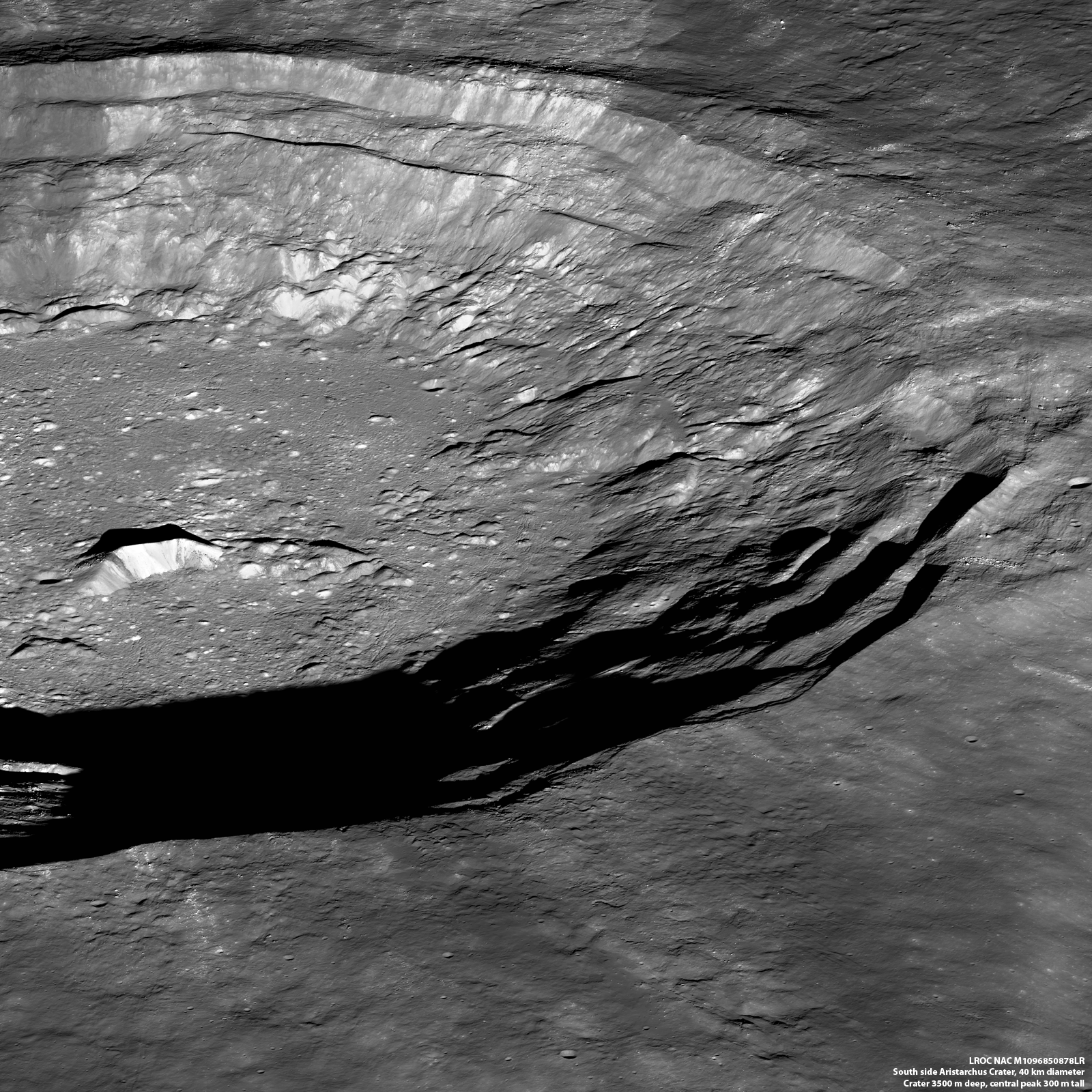
LROC view looking obliquely of the south rim of Aristarchus from the west (NASA/GSFC/Arizona State University)
Flying over at an altitude of 135 km, NASA’s Lunar Reconnaissance Orbiter captured this lovely oblique view of the crater Aristarchus, looking down at the 40-km (25-mile) -wide crater’s southern rim from the west.
The broad flank of Aristarchus’ 300-meter (980-foot) central peak and surrounding hills can be seen at left, casting lengthening shadows in the setting sun.
Named after the Greek astronomer who first proposed a controversial heliocentric model for the Solar System in the 3rd century BCE, Aristarchus is a prominent crater located near the Moon’s northwestern limb within the geologically-diverse Oceanus Procellarum — the “Ocean of Storms.” Surrounded by rays of bright ejecta that extend down its stepped rim, the floor of Aristarchus drops 3.7 km (2.3 miles) below the surrounding lunar landscape.
The bright material seen in the ejecta streaks seems to echo the patterns of light and dark material lining the slopes of Aristarchus’ central peak, suggesting that they may be the made of similar material.
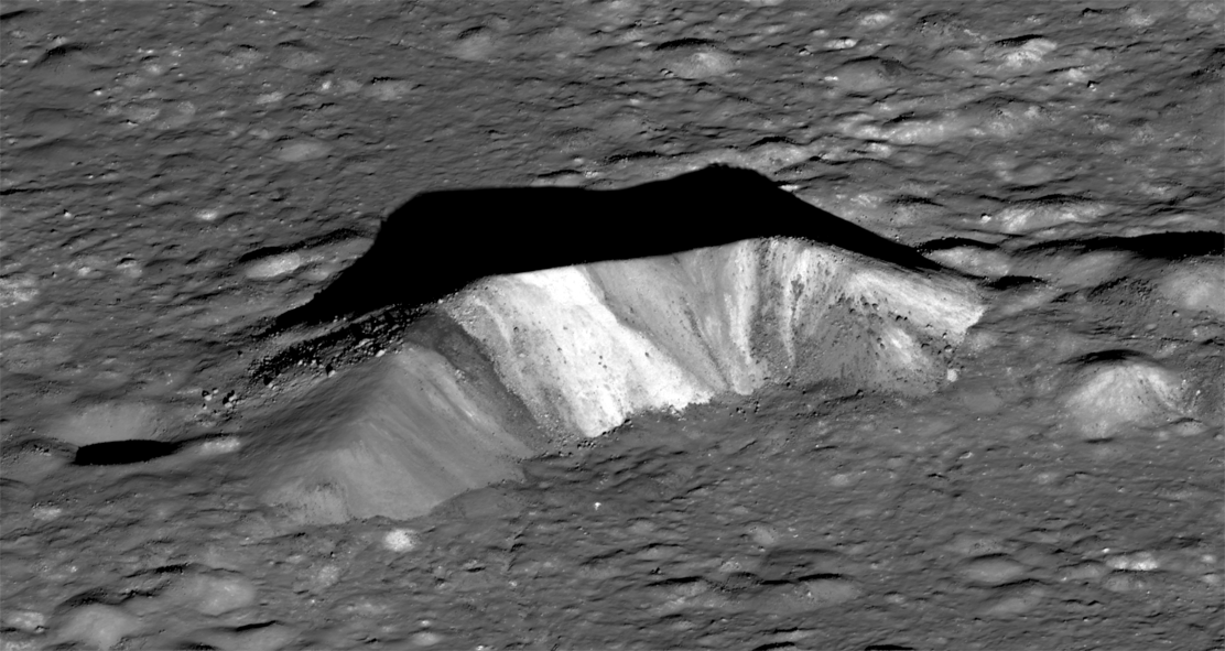
Detail of the 4.5-km-long central peak of Aristarchus (NASA/GSFC/Arizona State University)
The impact that created Aristarchus an estimated 450 million years ago excavated subsurface material, melting and spraying it tens of kilometers over the surrounding plateau. It’s thought that the central peak is likely composed of the same stuff, dredged up by the impact and frozen in place.
Future lunar explorers, should they ever visit this region, would be able to collect samples from the base of the central peak and compare them to samples from the bright rays to see if they match up, allowing researchers to learn about the composition of the material underlying the plateau from rocks scattered conveniently around the surface… this is the beauty of such (relatively) recent craters! The digging’s already been done for us.
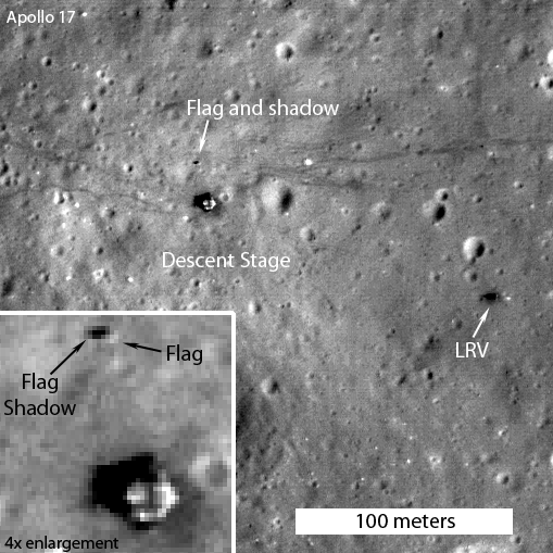
Caption: LROC image showing the illuminated side of the still standing American flag to be captured at the Apollo 17 landing site. Credit: NASA/GSFC/Arizona State University.
Mark Robinson, Principal Investigator of the Lunar Reconnaisance Orbiter Camera (LROC) says the most often-asked questions he gets about the images LRO has taken of the Moon are about pictures of the Apollo landing sites and what is visible. Especially, Robinson said, people want to know if the flags are still standing.
Previously, Robinson has said that while the flag poles are likely still standing, he didn’t think the flags themselves survived the harsh radiation of the lunar surface environment. But new images and video show that at some of the landing sites – Apollo 12, Apollo 16, and Apollo 17 – the flags must still be intact, because they are creating shadows on the surface.
“Personally I was a bit surprised that the flags survived the harsh ultraviolet light and temperatures of the lunar surface, but they did,” Robinson wrote on the LROC website. “What they look like is another question (badly faded?).”
Caption: The flag was captured in this image of the Apollo 16 site with the spacecraft slewed 15° towards the Sun; the shadowed side of the flag is seen by LROC. Credit: NASA/GSFC/Arizona State University.
James Fincannon, a NASA engineer from Glenn Research Center, combined LROC images of each Apollo site taken at roughly the same orientation but with different Sun angles to show the travel of shadows.
“Combined with knowledge of the Apollo site maps which show where the flag was erected relative to the Lander, long shadows cast by the flags at the three sites show that the these flags are still “flying”, held aloft by the poles,” Fincannon wrote.
And so, from the LROC images it is now certain that the American flags are still standing and casting shadows at all of the sites, except Apollo 11. Astronaut Buzz Aldrin reported that the flag was blown over by the exhaust from the ascent engine during liftoff of Apollo 11, and Robinson said that from the images of the Apollo 11 landing site, it looks like he was correct.
Caption: Enlargement of area surrounding Apollo 11 landing site. Credit: NASA/GSFC/Arizona State University
Robinson added that the most convincing way to see that the flags are still there, is to view a time series of LROC images taken at different times of day, and watch the shadow circle the flag (see movie below; the flag is just above the LM descent stage).
Caption: Southern rim of Giordano Bruno crater seen obliquely by LROC. Credit: NASA/GSFC/Arizona State University
At the 2012 Lunar Science Forum going on this week at the NASA Lunar Science Institute, scientist Mark Robinson presented some new stunning images from the Lunar Reconnaissance Orbiter’s cameras (LROC), including this oblique view Giordano Bruno crater, and a wonderful video (below) that allows viewers to “barnstorm” over the crater to witness the stark beauty of this impact basin.
“I could spend weeks and months looking at the preserved materials in the crater,” Robinson said, adding that views like this are helping scientists to understand the impact process. “Until astronauts visit Giordano Bruno, this gives a view about as close as you can get to standing on the surface to the west of the crater.”
Robinson is the Principal Investigator for LROC, and in his talk today said all systems on LROC are working nominally. “That’s NASA-speak for everything is fantastic,” he joked.
With the wide angle camera, LROC has mapped the entire Moon nearly 33 times. “Every map has a different photometric geometry, so this is not a redundant dataset,” Robinson said, adding that the different lighting provides different ways to study the Moon. “And to be able to do follow-up observations, I can’t tell you how great it is.”
Just about every month, the science team is able to take new mosaics of both the north and south pole, and they’ve also found 160 pits – lunar caves – so far. These caves with “skylights” are intriguing because they would offer potential protective habitats for future lunar explorers.
Now in its extended mission, LRO is still going strong, and has provided incredible details of the lunar surface. LRO project scientist Richard Vondrak said since the start of the mission, LRO has uploaded 325 terabytes of data into the Planetary Data System, the digital storehouse for NASA science mission, through June 2012.
Caption: Close-up detail of the rim of Giordano Crater. Credit: NASA/GSFC/Arizona State University
“Thanks to LRO, the Moon’s topography is now better understood than the Earth, since two-thirds of Earth is covered by water,” Vondrak said.
But both scientists agrees LRO is just getting started.
“The Moon is one of the most engaging bodies in the Solar System and we’ve still got a lot of work to do,” Robinson said
Robinson suggests scrolling through all of the details of this beautiful impact crater by looking at the full-resolution version of Giordano Crater — “not to be missed!” he said. Also, the full resolution version of the video can be downloaded here.
The LROC turns to capture the Moon's shadow during the May 20 solar eclipse [NASA/GSFC/Arizona State University].
[/caption]
The May 20 annular eclipse may have been an awesome sight for skywatchers across many parts of the Earth, but it was also being viewed by a robotic explorer around the Moon!
During the event NASA’s Lunar Reconnaissance Orbiter turned its camera to look back home, acquiring several images of the Earth with the Moon’s fuzzy shadow cast onto different regions during the course of the eclipse. The image above is a 4-panel zoom into one particular NAC image showing the Moon’s shadow over the Aleutian Islands.
LRO captured a total of four narrow-angle camera (NAC) images during two of its orbits. During one orbit the Moon’s shadow was over the southern part of Japan, and during the next it had moved northeast to cover the island chain of Alaska.
According to the LROC site run by Arizona State University:
The NAC is a line scanner, meaning that it has only one row of 5064 pixels per camera. Instead of snapping a single frame, an image is built up by the motion of the spacecraft in orbit about the Moon (about 1600 meters per second). To obtain an image of the Earth the spacecraft is turned 180° to face the Earth, then the spacecraft is pitched as quickly as possible (one-tenth of a degree per second), so that the image is built up line by line.
This also explains why some of the images are “clipped” on the edges… LRO ran out of time during its lunar orbit. Still, it’s great to be able to show some photos of the eclipse from quite possibly the most distant viewer anywhere!
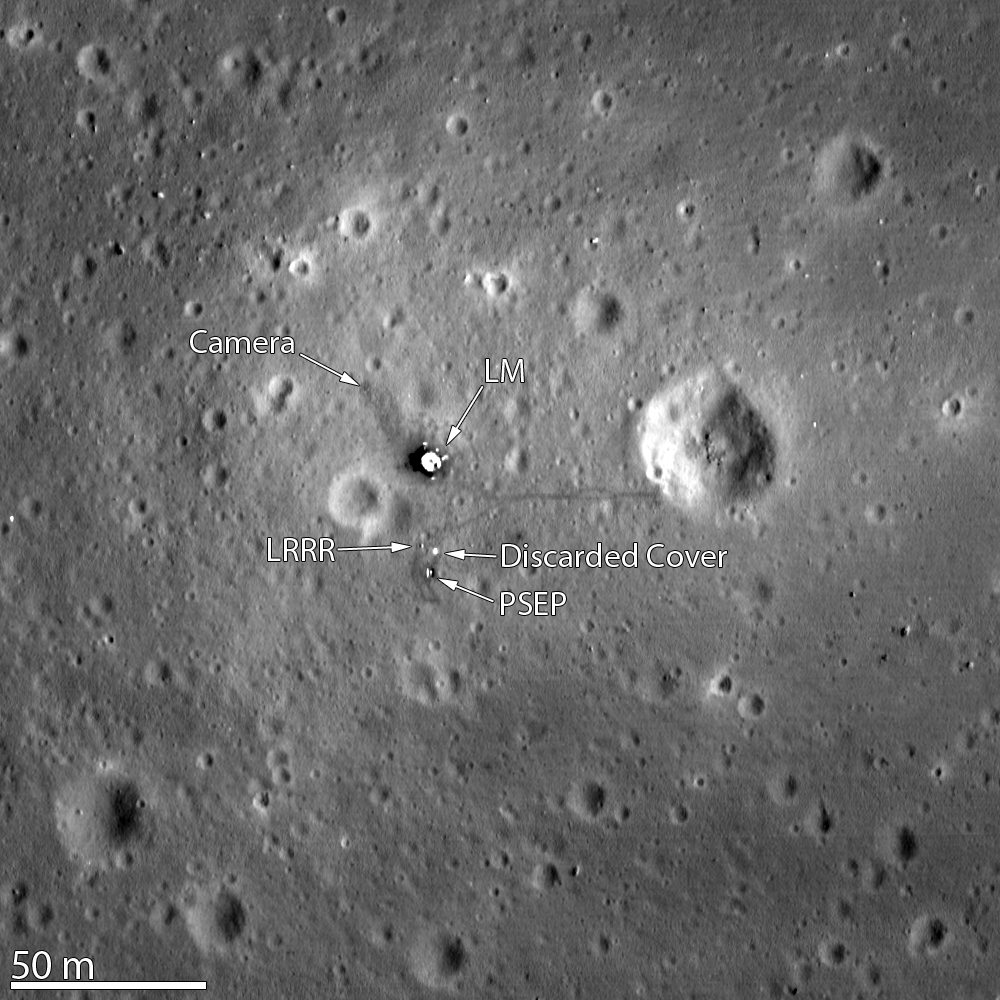
LROC image of the Apollo 11 landing site, acquired Nov. 5, 2011 (NASA/GSFC/Arizona State University)
[/caption]
Just over 42 years after Neil and Buzz became the first humans to experience the “stark beauty” of the lunar surface, the Lunar Reconnaissance Orbiter captured the remnants of their visit in the image above, acquired Nov. 5, 2011 from an altitude of only 15 miles (24 km). This is the highest-resolution view yet of the Apollo 11 landing site!
The Lunar Module’s descent stage, a seismic experiment monitor, a laser ranging reflector (LRRR, still used today to measure distances between Earth and the Moon) and its cover, and a camera can be discerned in the overhead image… as well as the darker trails of the astronauts’ bootprints, including Armstrong’s jaunt eastward to the rim of Little West crater.
The crater was the furthest the Apollo astronauts ventured; in fact, if you take the total area Neil and Buzz explored it would easily fit within the infield of a baseball diamond!
Neil Armstrong’s visit to the crater’s edge was an unplanned excursion. He used the vantage point to capture a panoramic image of the historic site:
Panorama of the Apollo 11 site from Little West crater. (NASA)
“Isn’t that something! Magnificent sight out here.” Armstrong had stated before he was joined by Aldrin on the lunar surface. “It has a stark beauty all its own. It’s like much of the high desert of the United States. It’s different, but it’s very pretty out here.”
Previously the LROC captured the Apollo 15 landing site, which included the tracks of the lunar rover — as well as the rover itself! And, just yesterday, the LROC site operated by Arizona State University featured the latest similarly high-resolution view of the Apollo 12 site. This location has the honor of being two landing sites in one: Apollo 12 and the Surveyor 3 spacecraft, which had landed on April 20, 1967 – two and a half years earlier!
The Apollo 12 landing site in Oceanus Procellarum. (NASA/GSFC/Arizona State University)
Even though the US flag planted by Apollo 12 astronauts Pete Conrad and Alan Bean isn’t itself visible, the shadow cast by it is.
Apollo 12 was the only mission to successfully visit the site of a previous spacecraft’s landing, and it also saw the placement of the first Apollo Lunar Surface Experiments Package (ALSEP), which included a seismometer and various instruments to measure the lunar environment.
Read more about this image on the LROC page here, and check out the video tour below of the Apollo 12 site.
Images and video courtesy of NASA/GSFC/Arizona State University
The remains of crumbled boulders in Schiller crater (NASA/GSFC/Arizona State University)
[/caption]
Breaking up may be hard to do, but these two lunar boulders seem to have succeeded extremely well! Imaged by the Lunar Reconnaissance Orbiter Camera (LROC) in October of 2009, this crumbled couple was recently identified by Moon Zoo team member Dr. Anthony Cook and brought to the attention of the project’s forum moderator.
The tracks left in the regolith — lunar soil — behind the boulders tell of their past rolling journeys down the slope of the elongated Schiller crater, in which they reside. Rolling boulders have been spotted before on the Moon, but what made these two split apart? And…why does that one on the lower right look so much like half a face?
Several things can cause lunar boulders to come loose and take the nearest downhill course. Meteorite impacts can shake the ground locally, giving the rocks enough of a nudge to set them on a roll. And moonquakes — the lunar version of earthquakes, as the name implies (although not due to tectonic plate shifts but rather to more mysterious internal lunar forces) — can also dislodge large boulders.
The low gravity on the Moon can make large rocks take a bounding path, evidenced by the dotted-line appearance of some of the trails.
Could all that bounding and bouncing have made the two boulders above shatter apart? Or was something else the cause of their crumbling?
Dr. Cook suggested that the boulders could have fractured before they began rolling, and then the added stress of their trip down the crater’s slope (uphill is to the right) made them break apart at the end of their trip… possibly due to further weathering and the extreme temperature variations of lunar days and nights.
Although a sound idea, Dr. Cook added, “I’m a bit puzzled though why the one on the top left has rock debris so far away from the centre. The boulder that looks like a skull rock on the bottom right has debris a lot closer to it, that could simply be explained by bits falling off as one would expect from the explanation above.”
This is one rock that's not happy about its breakup!
Another idea is that the boulders were struck by meteorites, but it seems extremely improbable that two would have been hit right next to each other. Still, not impossible, especially given the geologic time spans in play.
And as far as the “skull rock” boulder is concerned… that’s a little something called pareidolia, the tendency for our brains to interpret random shapes as something particularly significant. In this case it’s a human face, one of the most popular forms of pareidolia (perhaps best known by the famous “Face on Mars”, which, as we all now know, has been since shown to be just another Martian mesa.)
It does look like a face though, and not a particularly happy one!
Find out more about rolling boulders and Schiller crater on the LROC site hosted by Arizona State University here, and take a look at the full image scan of the region yourself… you may find more of these broken-up rolling rocks!
LROC WAC global 100-meter mosaic image of the 180-km long, 70-km wide Schiller crater. Overlaid onto a laser altimetry elevation model. (NASA/GSFC/Arizona State University)
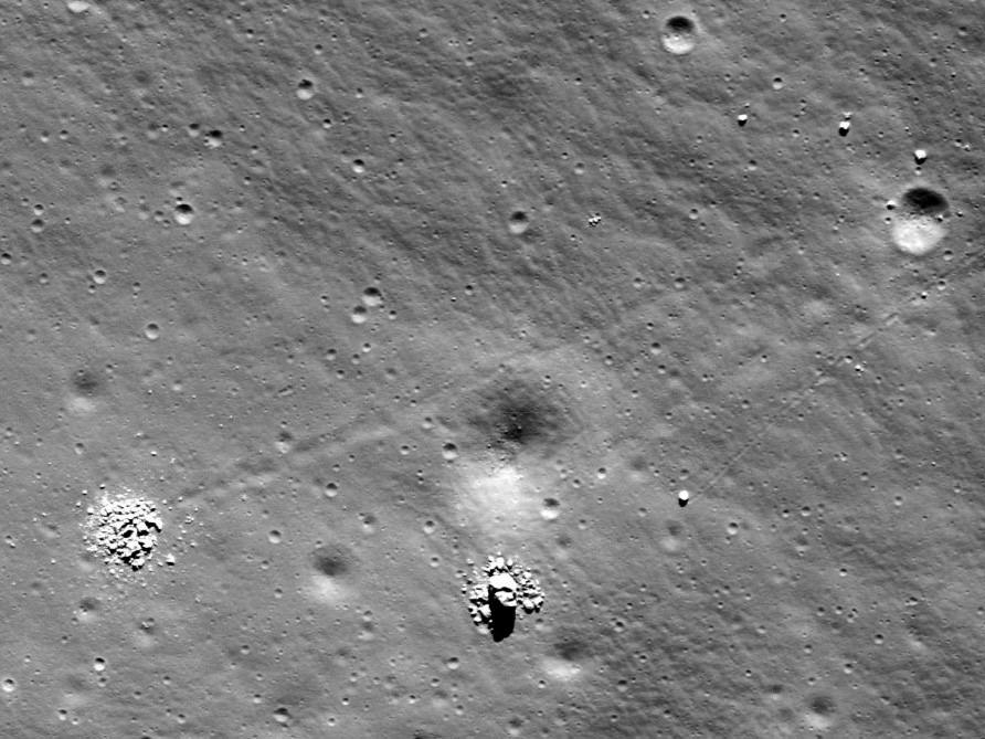
A large boulder stopped on its way down a sloping wall in the central peak of Schiller crater on the Moon. Credit: NASA/GSFC/Arizona State University.
[/caption]
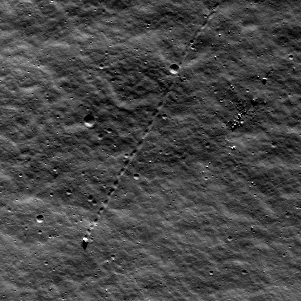
One solitary boulder on the Moon apparently decided to take a little journey. The Lunar Reconnaissance Orbiter Camera captured the track of a bouncing, rolling 9-meter boulder that used to sit along the rim of a crater. From the pristine nature of the tracks, it might seem that the rock may have taken its trip just recently. But with the high resolution capability of the LROC, scientists can see that a few tiny craters are superimposed among the track and therefore post-date the time the boulder traveled. Scientists estimate this track was created 50-100 million years ago.
“Though long ago to humans, however, this boulder’s journey was made in geologically recent times,” wrote lunar scientist James Ashley on the LROC website. “Studies suggest that regolith development from micrometeorite impacts will erase tracks like these over time intervals of tens of millions of years…Eventually its track will be erased completely.”
What might have caused the rock to roll so recently? Ashley said perhaps this boulder was sent on its way by ground-shaking caused by the violence of a nearby impact. Perhaps a direct hit by a small meteoroid did the job.
This isn’t the first time LRO has captured evidence of “moving” rocks. See our previous article about several other images of bouncing boulders.
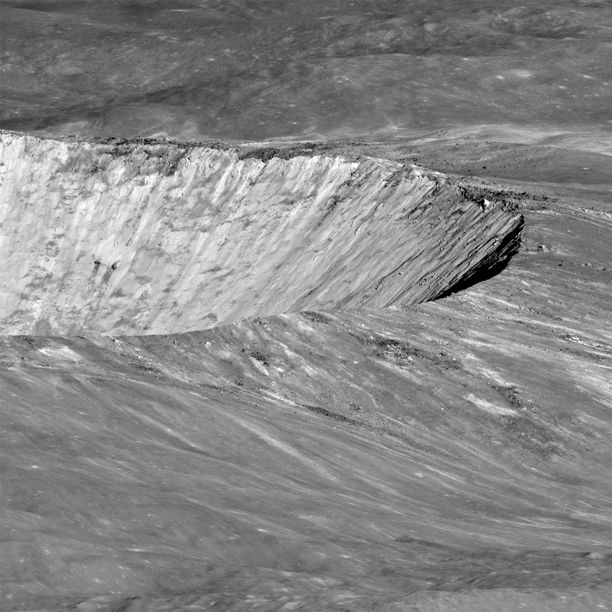
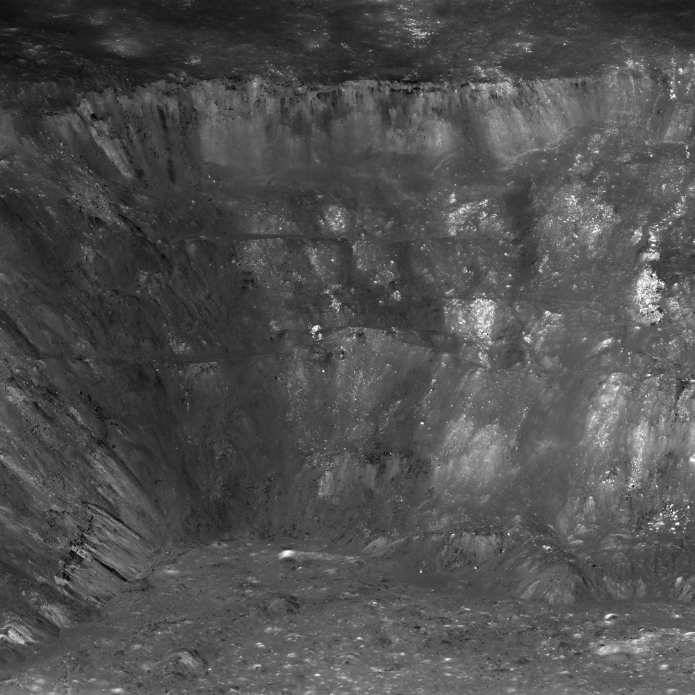
West wall of Aristarchus crater seen obliquely by the LROC NACs from an altitude of only 26 km. Scene is about 12 km wide at the base. Credit: NASA/GSFC/Arizona State University.
[/caption]
Have you ever you looked up at the bright, cavernous Aristarchus Crater on the Moon through a telescope or binoculars and wondered what it would be like to stand on the rim and peer inside? Spectacular new views from the Lunar Reconnaissance Orbiter is almost as good as being there, and a new video lets you “rappel” down and take a closer look at the west side of the crater walls.
Full panoramic view of the west wall of Aristarchus crater revealing impact melt deposits, exposures of high reflectance anorthosite, streamers of pyroclastic ash, and blocks up to 100 meters in size. Full width of panorama is about 25 km. Credit: NASA/GSFC/Arizona State University.
LRO Camera Principal Investigator Mark Robinson describes the region around the crater, known as the Aristarchus plateau, as one of the most geologically diverse places on the Moon. “A mysterious raised flat plateau, a giant rille carved by enormous outpourings of lava, fields of explosive volcanic ash, and all surrounded by massive flood basalts,” Robinson wrote on the LROC website. “A relatively recent asteroid (or comet) slammed into this geologic wonderland, blowing a giant hole in the ground revealing a cross section of over 3,000 meters (9,800 ft) of geology. No wonder planners for the Apollo missions put this plateau high on its list of targets for human exploration.”
These new amazing images were acquired on November 10, 2011 as LRO passed only 26 km (16.2 miles) above the surface, which is about two times lower than normal, due to LRO’s current elliptical orbit. The spacecraft was slewed to the west for an oblique or “sideways” look at the crater, instead of looking straight down as LRO normally does, to provide this unique perspective on Aristarchus. For a sense of scale, Robinson said that altitude is only a little over twice as high as commercial jets fly above the Earth. This crater is only one-tenth the size of Earth’s Grand Canyon, but the views from up above are similarly spectacular.
The location of Aristarchus Crater. Credit: Wikipedia
Aristarchus crater is located on the southeast edge of the Aristarchus Plateau. This yawning crater is 40 km wide and 3.5 km deep. The edges appear scalloped, almost like it crater was strip-mined. Since the crater is relatively young, Aristarchus is one of the brightest regions on the Moon. Robinson says these bright rocks may be anorthositic like the highlands, or they may be a more silicic rock like granite — or both.
“Although granites have been found in Apollo rock samples, the formation of granite on the Moon is not well understood at this time – another reason why we need to get samples from this region,” he said.
A 'straight down' view of Aristarchus, Aristarchus crater.. Small white arrows indicate approximate corners of the NAC panorama. Vertical line on right shows LRO orbit ground track Credit: NASA/GSFC/Arizona State University.
From this ‘straight down’ view, you can see the bright ejecta, contrasted by darker areas, which reflects the compositional difference between the various rocks in the region.
On the floor of Aristarchus crater is a wide variety of lunar rocks and geologic processes.
“Diverse materials such as dark, multilayered mare basalts in the walls, bright crustal rocks in the central peak, impact melt, and even regional pyroclastic materials blanketing the crater are brought to the floor and accumulated through mass wasting, creating a bountiful trove of geologic materials,” Robinson said.