Landsat 8’s Operational Land Imager captured this unique lenticular cloud that forms over the Otago region of New Zealand’s South Island. Image Credit: NASA/Lauren Dauphin; USGS
Filmmakers love New Zealand. Its landscapes evoke other worlds, which explains why so much of The Lord of the Rings was filmed there. The country has everything from long, subtropical sandy beaches to active volcanoes.
The country’s otherworldliness extends into its atmosphere, where a cloud nicknamed the “Taieri Pet” forms when conditions are right.
Modified data obtained by the ESA's Copernicus Sentinel-1 satellite. Credit: ESA/USGS
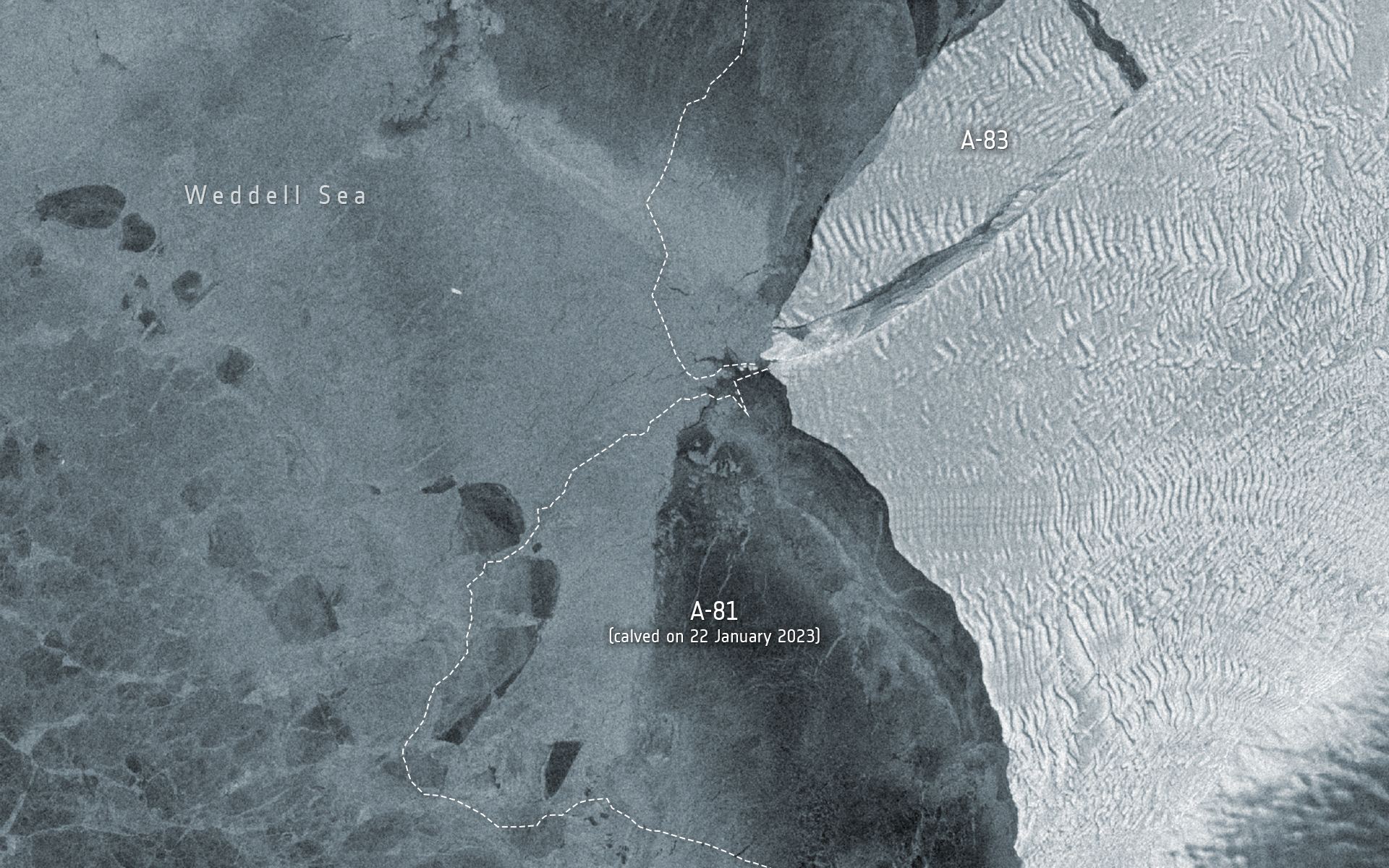
On May 20th, 2024, an iceberg measuring 380 square kilometers (~147 mi2) broke off the Brunt Ice Shelf in Antarctica. This event (A-83) is this region’s third significant iceberg calving in the past four years. The first came In 2021, when A-74 broke off the ice sheet, while an even larger berg named A-81 followed in 2023. The separation of this iceberg was captured by two Earth Observation satellites – the ESA’s Copernicus Sentinel-1 and NASA’s Landsat 8 satellites – which provided radar imaging and thermal data, respectively.
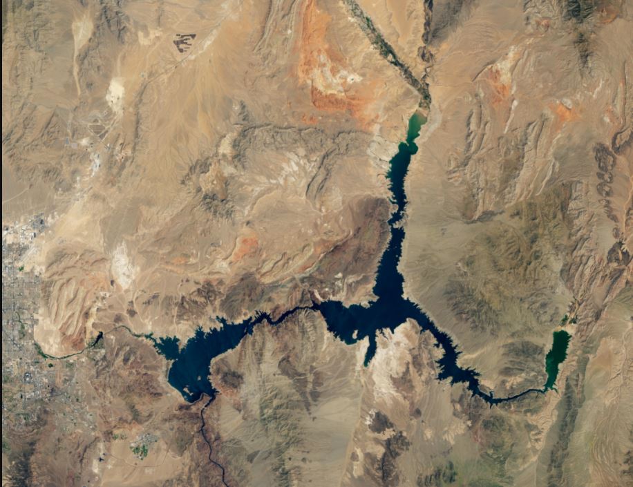
Lake Mead at record low levels, as seen on August 9, 2021 by the Landsat 8 satellite. Credit: NASA/NOAA
How bad is the drought in the western United States? A stunning depiction of the record dry spell comes in images of Lake Mead, the reservoir formed by the Hoover Dam on the Colorado River. NASA satellite images, below, from Landsat 7 and Landsat 8 show the difference in lake levels between August 2000 and August 2021.
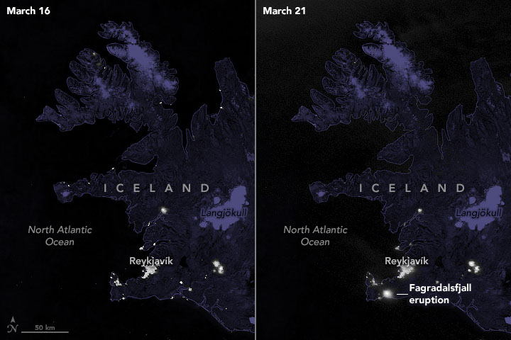
You’ve probably seen stunning images of the night side of the Earth from space. Most people have seen the veritable constellations of city lights scattered familiarly across the continents, separated by wide oceans of darkness. You very well may have seen some stunning videos from the ISS showing the dynamic and mesmerizing ribbons of the polar aurorae and the even more frenetic flashes of nighttime lightning storms. If you’re a frequent reader of this site, you’ve likely even seen the effects of rolling blackouts during the catastrophic winter storms of February 2021 in Houston, as seen from space. Add another explosively extraordinary phenomenon to the list of nighttime space views; the March 2021 volcanic eruption in Iceland!.
Landsat 8 is the United States Geological Survey’s most recently launched satellite, and it holds the powerful Operational Land Imager (OLI.) The OLI is a powerful multi-spectral imager with a wide dynamic range.
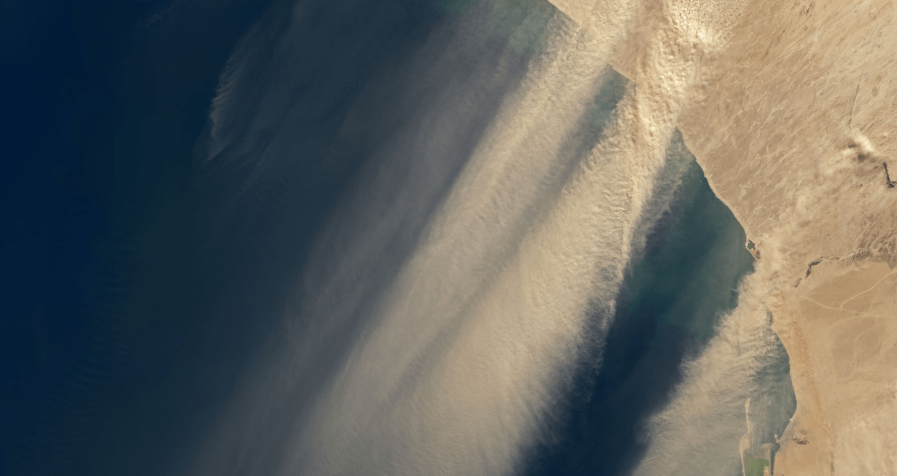
The OLI does a great job of keeping an eye on Earth, and now its captured images of winds in Namibia picking dust up and carrying it out over the Atlantic Ocean.
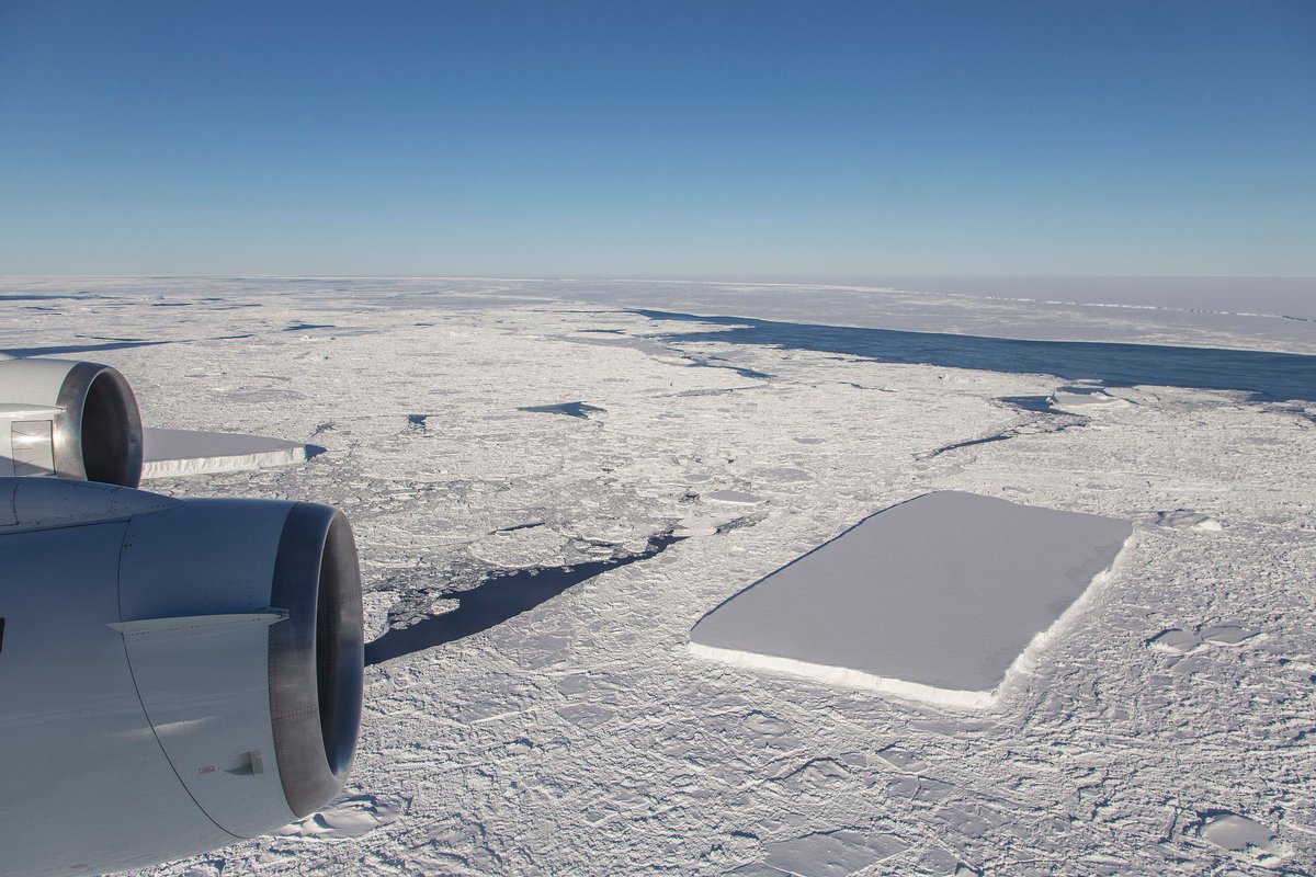
The rectangular iceberg spotted in mid-October had a much longer and more perilous journey than we thought. Image Credit: NASA/Jeremy Harbeck
That stunning rectangular iceberg that was photographed in mid-October by NASA scientist Jeremy Harbeck had a much more harrowing journey than we thought. Scientists looked back through satellite images to retrace the ‘berg’s journey. They found that it calved from the Larsen C Ice Shelf in November 2017.
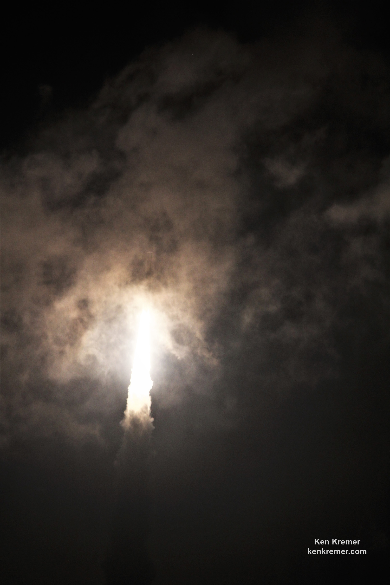
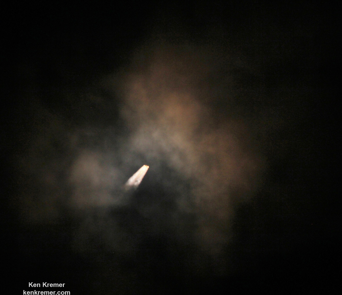
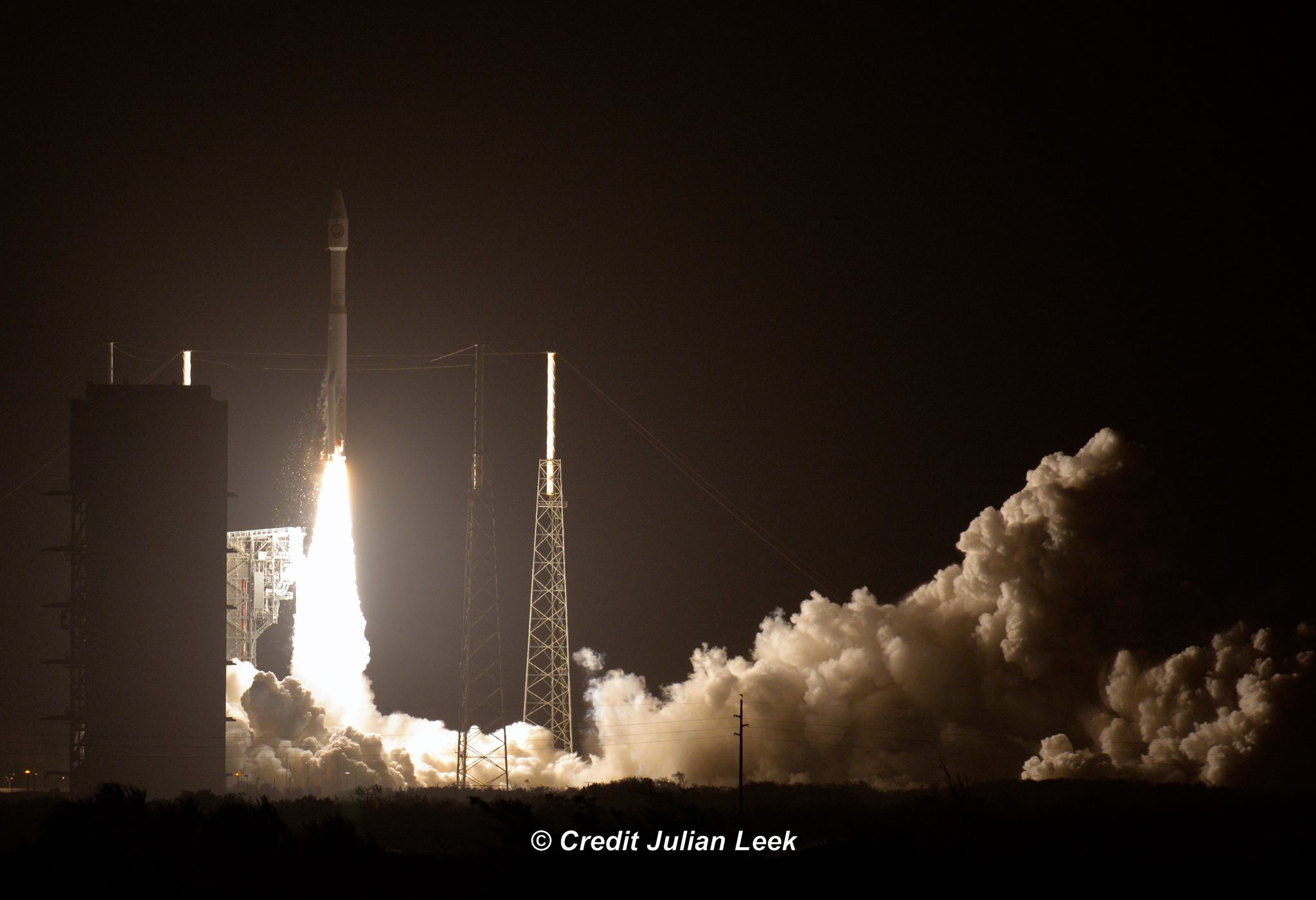
Covert NROL-52 spy satellite for the National Reconnaissance Office fades into cloudy nighttime skies shrouded in secrecy after liftoff on a United Launch Alliance (ULA) Atlas V rocket at 3:28 a.m. EDT on Oct. 15, 2017 from Space Launch Complex-41 at Cape Canaveral Air Force Station in Florida. Credit: Ken Kremer/kenkremer.com
Covert NROL-52 spy satellite for the National Reconnaissance Office fades into cloudy nighttime skies shrouded in secrecy after liftoff on a United Launch Alliance (ULA) Atlas V rocket at 3:28 a.m. EDT on Oct. 15, 2017 from Space Launch Complex-41 at Cape Canaveral Air Force Station in Florida. Credit: Ken Kremer/kenkremer.com
CAPE CANAVERAL AIR FORCE STATION, FL — As one Atlas rocket carrying a covert spy satellite for the U.S. National Reconnaissance Office (NRO) to monitor Earth for national security purposes faded into cloudy nighttime skies over the Cape in the dead of night shrouded in liftoff secrecy, rocket builder United Launch Alliance (ULA) won another significant Atlas launch contract for NASA’s Landsat 9 satellite to monitor the health of Earth’s environment.
Capping two launches from two different rocket companies in four days by ULA and SpaceX followed by the arrival back in port of SpaceX’s ocean landed recovered booster, last week provided all the proof that’s needed to demonstrate that the revitalization of Florida’s Spaceport is well underway and America’s rocket makers are capturing lucrative launch contracts ensuring an upswing nationwide in rocket and spacecraft manufacturing – for critical military surveillance, government, civilian and science needs.
Check out the exciting gallery of Atlas launch imagery and videos including the thrilling droneship return of SpaceX’s 156 foot tall first stage booster back into Port Canaveral less than 4 hours after ULA delivered the classified NROL-52 surveillance satellite to a secret orbit – from this author and several space media colleagues. And check back here as the gallery grows!
A ULA Atlas V launch carrying the covert NROL-52 mission in support of U.S. national security blasted off overnight Sunday, Oct. 15 at 3:28 a.m. EDT (0728 GMT) from seaside Space Launch Complex-41 at Cape Canaveral Air Force Station in Florida.
“Congratulations to the team who helped make #NROL52 a success! United Launch Alliance, 45th Space Wing at Patrick Air Force Base, Fla., Air Force Space Command, and the Space and Missile Systems Center,” the NRO announced post launch on social media.
It was a case of ‘Going, Going, Gone’ as seemingly endless stormy weather plagued the space coast and the Atlas soon disappeared behind clouds from many but not all vantage points, as the two stage rocket was finally cleared to launch on its fifth try. Postponed three times by poor weather and once due to a technical glitch to fix a faulty second stage transmitter.
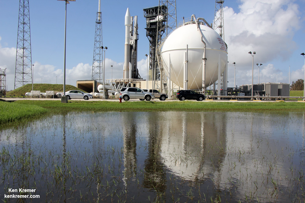
Reflecting in a pond a United Launch Alliance (ULA) Atlas V rocket blasts off with the covert NROL-52 spy satellite for the National Reconnaissance Office at 3:28 a.m. EDT on Oct. 15, 2017 from Space Launch Complex-41 at Cape Canaveral Air Force Station in Florida. Credit: Ken Kremer/kenkremer.com
“We’ve had an incredible month,” said Brig. Gen. Wayne R. Monteith, Commander, 45th Space Wing.
“Not only did we restore our base to full mission capable status just a few hours after Hurricane Irma impacted our coast, but we’ve successfully launched two rockets in less than four days just weeks later.”
Covert NROL-52 spy satellite for the National Reconnaissance Office fades into cloudy nighttime skies shrouded in secrecy after liftoff on a United Launch Alliance (ULA) Atlas V rocket at 3:28 a.m. EDT on Oct. 15, 2017 from Space Launch Complex-41 at Cape Canaveral Air Force Station in Florida. Credit: Ken Kremer/kenkremer.com
“The 45th Space Wing supported ULA’s Atlas V launch of the NROL-52 mission for the National Reconnaissance Office early morning on Oct. 15!”
“The men and women of the 45th Space Wing continue to make the impossible possible.”
Reflecting in a pond a United Launch Alliance (ULA) Atlas V rocket blasts off with the covert NROL-52 spy satellite for the National Reconnaissance Office at 3:28 a.m. EDT on Oct. 15, 2017 from Space Launch Complex-41 at Cape Canaveral Air Force Station in Florida. Credit: Ken Kremer/kenkremer.com
More than a quarter of all the world’s rocket launches take place from Florida’s burgeoning spaceports.
Covert NROL-52 spy satellite for the National Reconnaissance Office fades into cloudy nighttime skies shrouded in secrecy after liftoff on a United Launch Alliance (ULA) Atlas V rocket at 3:28 a.m. EDT on Oct. 15, 2017 from Space Launch Complex-41 at Cape Canaveral Air Force Station in Florida. Credit: Ken Kremer/kenkremer.com
“Our team’s resiliency and tireless efforts in launching over 25% of all world-wide launches this year proves why we are the ‘World’s Premier Gateway to Space,’” Montieth gushed in pride.
Meanwhile, NASA selected ULA to provide launch services for the Landsat 9 mission with another Atlas V rocket as soon as late 2020.
“The mission is currently targeted for a contract launch date of June 2021, while protecting for the ability to launch as early as December 2020, on an Atlas V 401 rocket from Space Launch Complex 3E at Vandenberg Air Force Base in California,” said NASA.
The Landsat 9 launch contract is worth $153.8 million.
Landsat 9 is a joint mission between NASA and the U.S. Geological Survey (USGS).
“Landsat 9 will continue the Landsat program’s critical role in monitoring, understanding, and managing the land resources needed to sustain human life.”
“We are honored that NASA has entrusted ULA with launching this critical land imaging satellite,” said Tory Bruno, ULA’s president and chief executive, in a statement.
“ULA’s world-leading performance and reliability, paired with the tremendous heritage of 74 consecutive successful Atlas V launches, provides the optimal value for our customer. We look forward to working together again with our mission partners at NASA’s Launch Services Program, Goddard Space Flight Center and the U.S. Geological Survey in the integration and launch of this significant mission, contributing to the international strategy for examining the health and state of the Earth.”
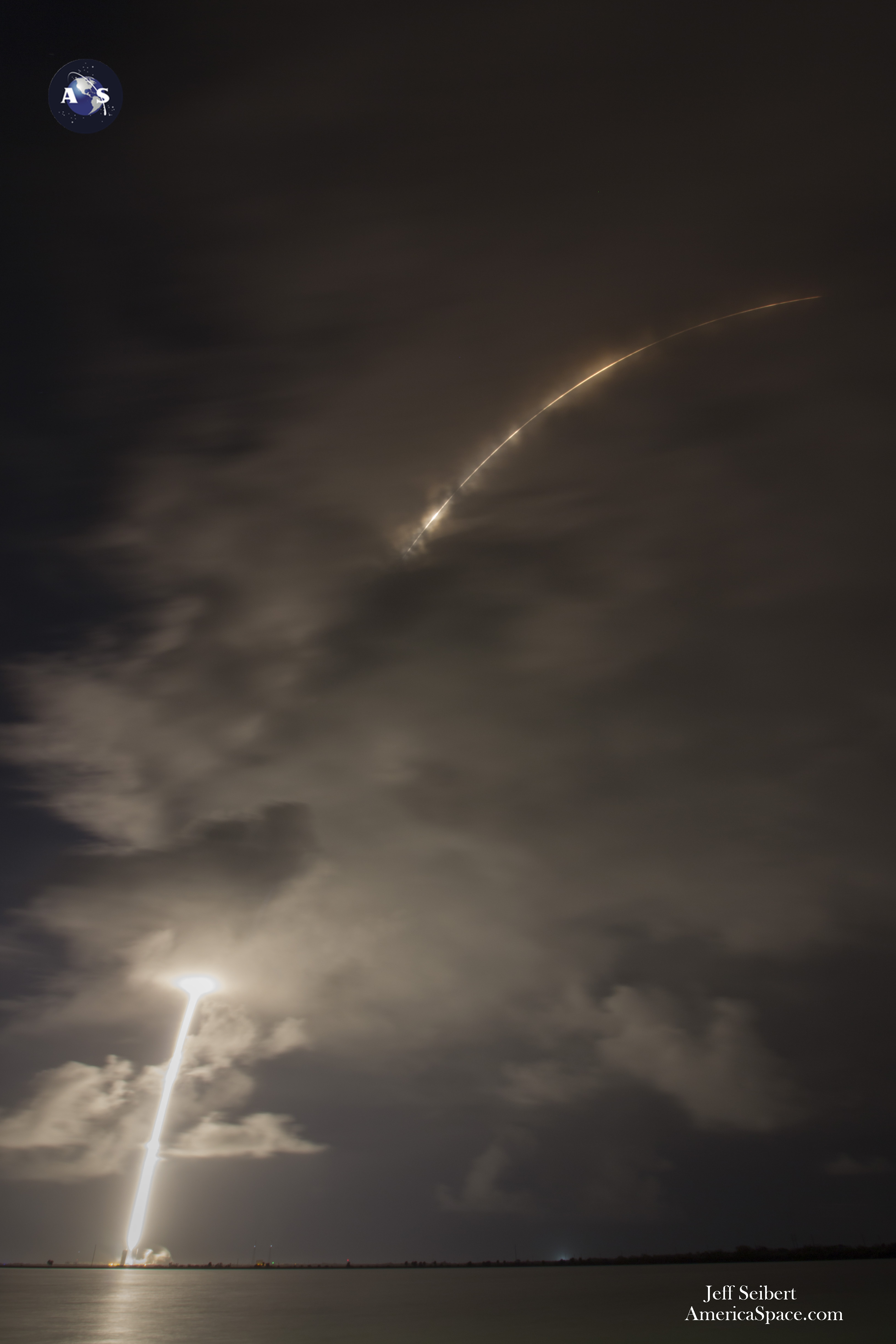
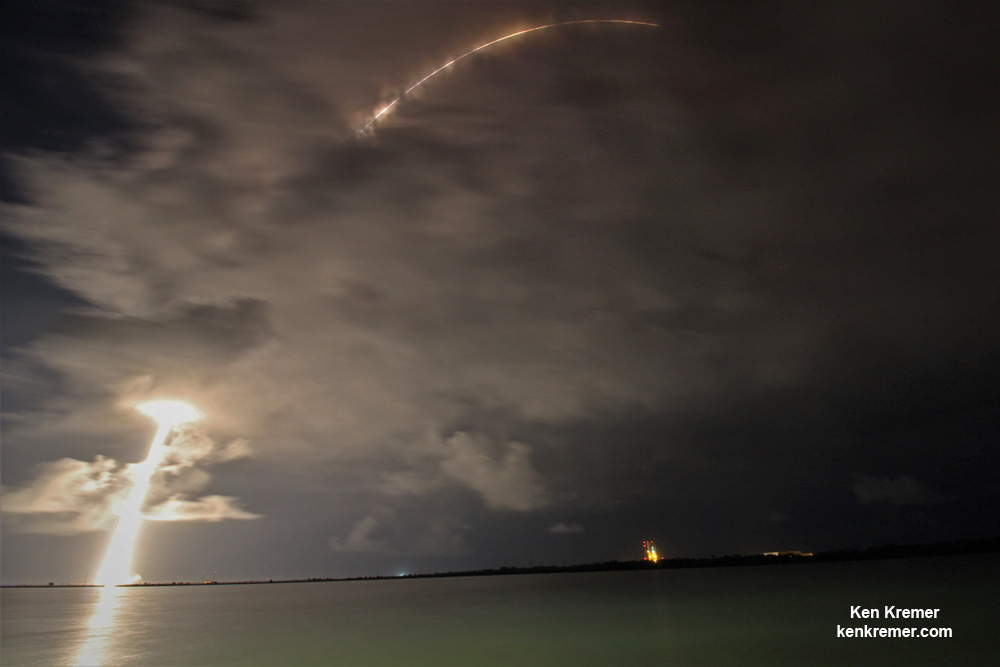
ULA Atlas V rocket streaks to orbit in this long duration exposure carrying covert NROL-52 payload for the NRO after lift off from Space Launch Complex-41 on Oct. 15, 2017 at 3:28 a.m. EDT at Cape Canaveral Air Force Station in Florida. Credit: Jeff Seibert
NROL-52 is the fourth of five launches slated for the NRO in 2017 by both ULA and SpaceX.
“Never before has innovation been more important for keeping us ahead of the game. As the eagle soars, so will the advanced capabilities this payload provides to our national security,” said Colonel Matthew Skeen, USAF, Director, NRO Office of Space Launch, in a statement. “Kudos to the entire team for a job well done.”
Check out this exciting video compilation from remote cameras circling the Atlas pad 41.
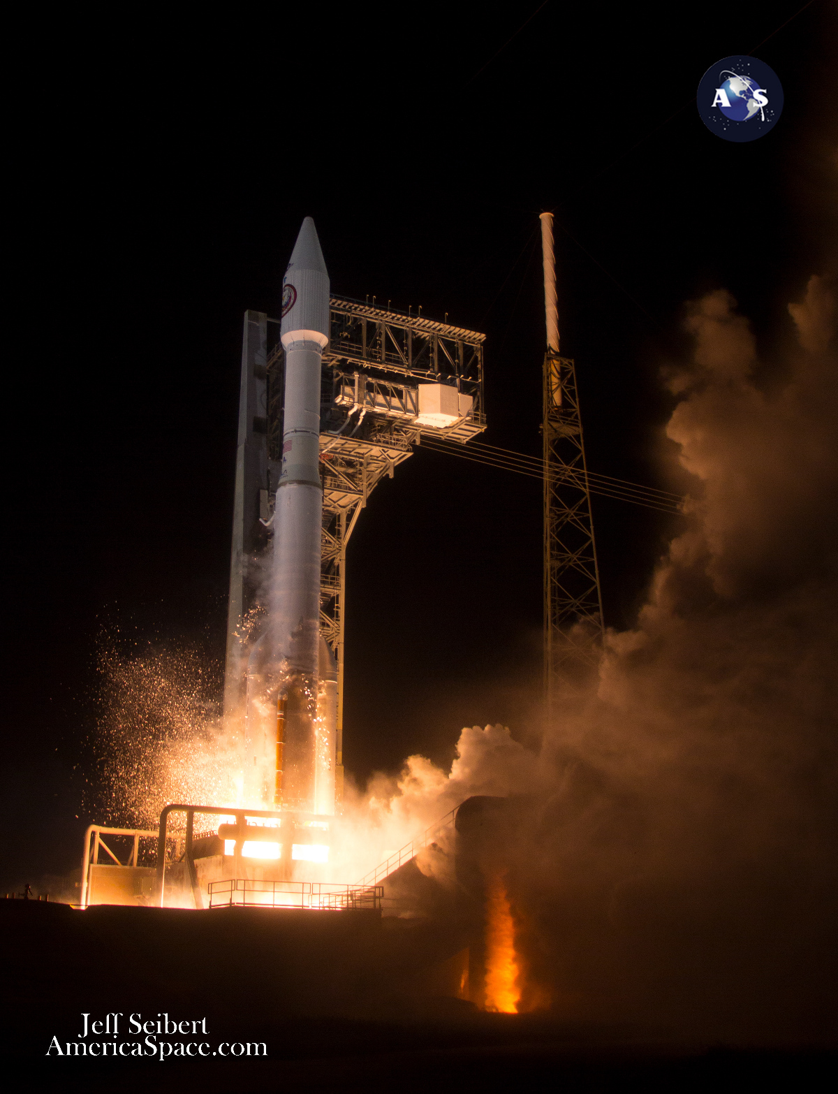
Video Caption: Launch of the NROL-52 satellite on an Atlas 5 booster from Pad 41. A United Launch Alliance Atlas 5 421 rocket launches the NROL-52 payload on Oct. 15, 2017 at 328 a.m. EDT on the 5th launch attempt. Previous launch attempts were halted by weather issues 3 times, and a faulty telemetry radio that needed to be replaced after the rocket was rolled back to the Pad 41 Vertical Integration Facility. Credit Jeff Seibert
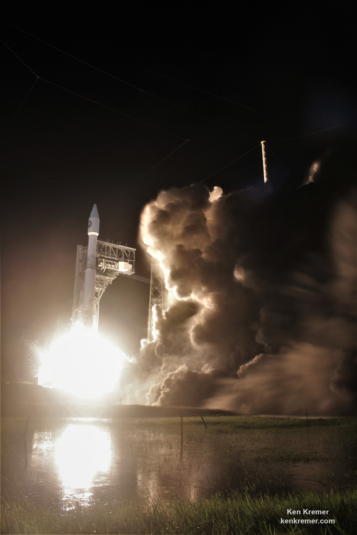
The venerable two stage Atlas V stands 194 feet tall and sports a 100% success record. The first stage generates approx. 1.6 million pounds of liftoff thrust.
This Atlas Evolved Expendable Launch Vehicle (EELV) mission launched in the 421 configuration vehicle, which includes a 4-meter payload fairing (PLF) encapsulating the payload and two strap on solid rocket first stage boosters.
The Atlas first stage booster for this mission was powered by the Russian-built RD AMROSS RD-180 engine, and the Centaur upper stage was powered by the Aerojet Rocketdyne RL10C-1 engine.
The dual chamber, dual-nozzle RD-180 is fueled by a mixture of RP-1 kerosene and LOX (liquid oxygen).
The ULA Atlas V first stage powers NROL-52 spy satellite to orbit for the NRO firing the dual chamber, dual-nozzle RD-180 engines after blastoff at 3:28 a.m. EDT on Oct. 15, 2017 from Space Launch Complex-41 at Cape Canaveral Air Force Station in Florida. Credit: Ken Kremer/kenkremer.com
The next NRO launch is scheduled on a ULA Delta IV in December from Vandenberg Air Force Base, California.
Reflecting in a pond a United Launch Alliance (ULA) Atlas V rocket blasts off with the covert NROL-52 spy satellite for the National Reconnaissance Office at 3:28 a.m. EDT on Oct. 15, 2017 from Space Launch Complex-41 at Cape Canaveral Air Force Station in Florida. Credit: Ken Kremer/kenkremer.com
Watch for Ken’s continuing onsite NROL-52, SpaceX SES-11 and NASA and space mission reports direct from the Kennedy Space Center and Cape Canaveral Air Force Station, Florida.
Stay tuned here for Ken’s continuing Earth and Planetary science and human spaceflight news.
Liftoff of ULA Atlas V rocket carrying classified NROL-52 payload for the NRO on Oct. 15, 2017 from Cape Canaveral Air Force Station in Florida. Credit: Julian Leek
United Launch Alliance (ULA) Atlas V rocket streaks to orbit in this long duration exposure carrying covert NROL-52 payload for the National Reconnaissance Office after lift off from Space Launch Complex-41 on Oct. 15, 2017 at 3:28 a.m. EDT at Cape Canaveral Air Force Station in Florida. Credit: Ken Kremer/kenkremer.com
Reflecting in a pond a ULA Atlas V rocket stands poised for launch with the NROL-52 surveillance satellite for the National Reconnaissance Office prior to blastoff on Oct. 15, 2017 from Space Launch Complex-41 at Cape Canaveral Air Force Station in Florida. Credit: Ken Kremer/kenkremer.com
Reflown SpaceX Falcon 9 first stage booster arrives at sunrise atop OCISLY droneship being towed into the mouth of Port Canaveral, FL on Oct. 15, 2017 after successfully launch SES-11 UHDTV comsat to orbit on Oct. 11, 2017. Credit: Ken Kremer/Kenkremer.com
ULA Atlas V rocket blasts off carrying covert NROL-52 payload for the NRO from Space Launch Complex-41 on Oct. 15, 2017 at 3:28 a.m. EDT at Cape Canaveral Air Force Station in Florida. Credit: Jeff Seibert
A view from Earth orbit of the Longyangxia Dam Solar Park in China. Credit: NASA/Landsat 8.
While the Great Wall of China is not readily visible from space (we debunked that popular myth here) there are several other human-built structures that actually can be seen from space. And that list is growing, thanks to the large solar farms being built around the world.
The solar farm with the current distinction of being the largest in the world — as of February 2017 – is the Longyangxia Dam Solar Park in China. These new images from NASA’s Landsat 8 satellite show the farm’s blue solar panels prominently standing out on the brown landscape of the western province of Qinghai, China. Reportedly, the solar farm covers 27 square kilometers (10.42 square miles), and consists of nearly 4 million solar panels.
You can see in the image below from 2013 that the farm has been growing over the years. The project has cost the amount of 6 billion yuan ($889.5 million).
The orbital view from April 16, 2013 of the Longyangxia Dam Solar Park in China. Credit: NASA/Landsat 8.
China wants to shed its title of the biggest polluter in the world and is now investing in clean, renewable energy. It has a goal of producing 110 GW of solar power and 210 GW of wind power by the year 2020. That sounds like a lot, but in a country of 1.4 billion people that relies heavily on coal, it amounts to less than 1 percent of the country’s more than 1,500 gigawatts of total power generation capacity, says Inside Climate News.
According to NASA, China is now the world’s largest producer of solar power, however Germany, Japan, and the United States produce more solar power per person.
China has another solar farm in the works that will have a capacity of 2,000 MW when it is finished.
Here’s another wider-angle view from Landsat 8 of the Longyangxia Dam and lake near the solar farm.
The Longyangxia Dam Solar Park as seen from orbit on January 5, 2017. Credit: NASA/Landsat 8.
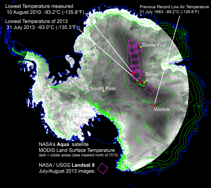
With remote-sensing satellites, scientists have found the coldest places on Earth, just off a ridge in the East Antarctic Plateau. The coldest of the cold temperatures dropped to minus 135.8 F (minus 93.2 C) -- several degrees colder than the previous record.
Image Credit: Ted Scambos, National Snow and Ice Data Center.
What is the coldest place on Earth? Scientists say it’s a place so cold that ordinary mercury or alcohol thermometers won’t work there. If you were there, every breath would be painful, your clothing would crackle every time you moved, and if you threw hot water into the air, it would fall to the ground as tiny shards of ice. At this place, the new record of minus 136 F (minus 93.2 C) was set on Aug. 10, 2010. Researchers analyzed data from several satellite instruments and found the coldest place on Earth in the past 32 years is … a high ridge in Antarctica between Dome Argus and Dome Fuji, two summits on the ice sheet known as the East Antarctic Plateau. Temperatures in several hollows were found to dip to the new record.
“We had a suspicion this Antarctic ridge was likely to be extremely cold,” said Ted Scambos, from the National Snow and Ice Data Center in Boulder, Colorado. “With the launch of Landsat 8, we finally had a sensor capable of really investigating this area in more detail.”
This beats out the previous low of minus 128.6 F (minus 89.2 C), set in 1983 at the Russian Vostok Research Station in East Antarctica. The coldest permanently inhabited place on Earth is northeastern Siberia, where temperatures in the towns of Verkhoyansk and Oimekon dropped to a bone-chilling 90 degrees below zero Fahrenheit (minus 67.8 C) in 1892 and 1933, respectively.
Scambos and his team made the discovery while analyzing the most detailed global surface temperature maps to date, developed with data from remote sensing satellites. The new findings were reported at the American Geophysical Union meeting in San Francisco.
The pursuit to find the coldest place on Earth started when the researchers were studying large snow dunes, sculpted and polished by the wind, on the East Antarctic Plateau. When the scientists looked closer, they noticed cracks in the snow surface between the dunes, possibly created when wintertime temperatures got so low the top snow layer shrunk. This led scientists to wonder what the temperature range was, and prompted them to hunt for the coldest places using data from two types of satellite sensors.
They used data from the Moderate Resolution Imaging Spectroradiometer (MODIS) instruments on NASA’s Terra and Aqua satellites and the Advanced Very High Resolution Radiometer (AVHRR) on several National Oceanic and Atmospheric Administration satellites. These sensitive instruments can pick up thermal radiation emitted from Earth’s surface, even in areas lacking much heat.
Using these sensors to scan the East Antarctic Plateau, Scambos detected extremely cold temperatures on a 620-mile stretch of the ridge at high elevations between Argus and Fuji, and even colder temperatures lower elevations in pockets off the ridge. Then, with the higher resolution of the Thermal Infrared Sensor (TIRS) aboard Landsat 8, the research team pinpointed the record-setting pockets.
The team compared the sites to topographic maps to explore how it gets so cold. Already cold temperatures fall rapidly when the sky clears. If clear skies persist for a few days, the ground chills as it radiates its remaining heat into space. This creates a layer of super-chilled air above the surface of the snow and ice. This layer of air is denser than the relatively warmer air above it, which causes it to slide down the shallow slope of domes on the Antarctic plateau. As it flows into the pockets, it can be trapped, and the cooling continues.
“By causing the air to be stationary for extended periods, while continuing to radiate more heat away into space, you get the absolute lowest temperatures we’re able to find,” Scambos said. “We suspected that we would be looking for one magical site that got extremely cold, but what we found was a large strip of Antarctica at high altitude that regularly reached these record low temperatures.”
Artist's conception of Landsat 8 (renamed from Landsat Data Continuity Mission). Credit: NASA/ Goddard/Conceptual Image Lab
Landsat 8 officially opened its eyes to Earth yesterday (May 30). Officials are promising the clearest views yet of the four-decade-old Landsat program, and luckily for people who love amazing Earth views, the images Landsat produces are free.
Before talking a bit about Landsat 8, here’s one way you can find the images: go to this website of raw Landsat data from the United States Geological Survey. In the menu tab “Collection”, go down to “Landsat Archive” and select “Landsat 8 OLI.” Then click a location on the map to see if it’s taken a picture of a spot you’re interested in.
Once you’ve selected it, hit “Add Scene”, then click on the scene list at the bottom right of the screen to download the product. (We’d strongly advise consulting the tutorial on that website for more help. You need to register as a user to download the high-resolution images.)
There isn’t much to see there yet, but over the next few months there should be a wealth of pictures to choose from. More spots where Landsat 8 data will appear are listed on this USGS page.
You may better recall Landsat 8 as the Landsat Data Continuity Mission. Launched on Feb. 11, it was first under the operational control of NASA as the agency put the satellite through its paces — placing it into the proper orbit (it circles in a near-polar orbit) and taking some test images of the planet, for example.
Now that the satellite is ready, the USGS has operational control and will add that to more than 40 years of data collected under the Landsat program. The aim, we assure you, is not just for pretty pictures.
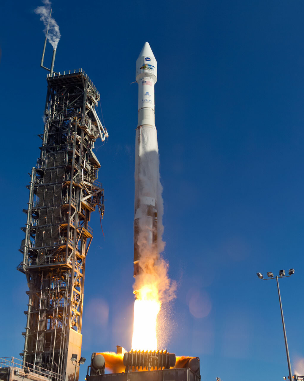
An Atlas-V rocket with the Landsat Data Continuity Mission (LDCM) spacecraft onboard is seen as it launches on Monday, Feb. 11, 2013 at Vandenberg Air Force Base, California. Credit: NASA
Long Earth observation programs show changes in the land over time. We can see cities grow, observe forests shrink or deserts expand in response to human activity or climate change, and also gauge the impact of natural disasters. In the past, Landsat pictures have been used to map the impact of the Mount St. Helen’s eruption of 1980, and to respond to oil gas fires set in Kuwait during the Gulf War of 1991.
These are heavyweight satellites. The truck-sized Landsat 8 weighs 4,566 lbs (2,071 kg) fully loaded with fuel, excluding the weight of the instruments. Its operational land imager can take pictures in nine spectral bands, which is important because certain types of vegetation or land features show up better in different light spectra. (One application is to monitor the health of certain kind of plants in farmer fields, for example.) It also has two thermal infrared sensor bands that will show the heat signature of Earthly features.
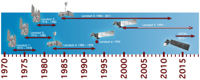
For Landsat, officials needed to launch this satellite because its predecessor (Landsat 7)’s operational lifetime is in overtime. Should the satellite have failed before Landsat 8 arrived, 41 years of continuous Earth observations under the same program would have ceased.
Landsat 8 will circle the globe 14 times daily, will repeat its ground track every 16 days, and is expected to do this for at least five years. Check out this USGS feature story for more on how it will contribute to Earth observation.
Timeline showing lifespans of the Landsat satellites. Credit: NASA