Tallest Mountains

Olympus Mons. Image credit: NASA/JPL

[/caption]

There are many tall mountains around the world as well as on other worlds. Mount Everest is the highest mountain in the world at 8,848 meters. Mauna Kea is the tallest mountain in the world. The tallest mountain is measured from base to top while the highest mountain is measured from sea level to the top.  Everest is located in the Himalayan mountain range in Nepal and near Tibet. Mauna Kea is located in Hawaii and is 10,200 meters from base to tip. From sea level though, it is only about 4,205 meters tall.  Mauna Kea is an extinct shield volcano.

These are not the only tall mountains though. K2 is in the Karakoram mountain range on the border of Pakistan and China. It is 8,612 meters tall and is generally considered the second tallest mountain in the world. The Himalayans are home to many tall mountains besides Mount Everest. This includes Mount Kangchenjunga at 8,586 meters and Mount Lhotse I at 8,501 meters.

Most of the world’s tallest mountains are located in Asia; however, there are a number of tall mountains that are located on other continents. The seven tallest mountains in different continents are known as the Seven Summits. Climbing all seven mountains is a mountaineering challenge that was started in the 1980’s.The first of these is Mount Everest. Another summit is Aconcagua, which is a mountain in Argentina in South America. At approximately 6,962 meters, it is the tallest mountain in the Americas. North America’s tallest mountain is Mount McKinley at 6,194 meters. Mount Kilimanjaro can be found in Tanzania in the continent of Africa and is 5,895 meters tall. The large summit of Mount Kilimanjaro is covered with an ice cap that is receding and according to scientists will eventually be gone. Mount Elbrus, the tallest mountain in Europe at 5,642 meters, can be found in Russia. Vinson Massif is Antarctica’s tallest mountain at 4,897 meters. It is also very large being 21 kilometers long and 13 kilometers wide.  Australia-Oceania’s largest mountain can be found in Indonesia. At 4,884 meters, it is Puncak Jaya, which is also known as the Carstensz Pyramid.

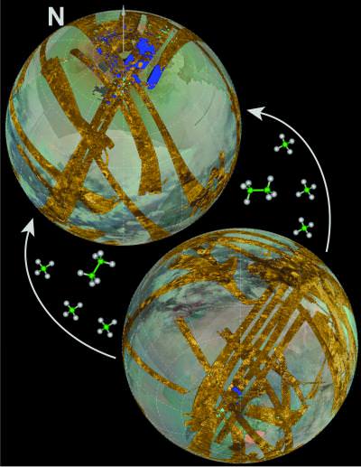
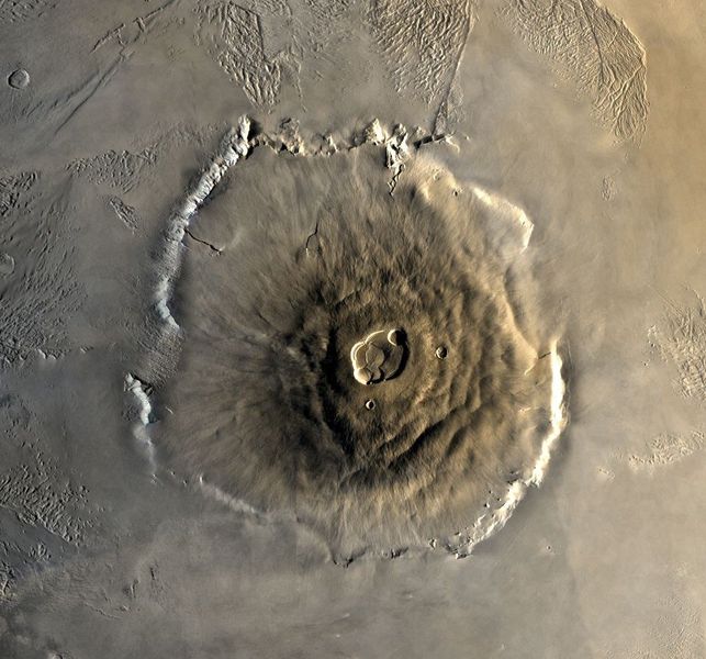
The tallest mountain that we know of is not even on Earth. It is located on Mars and is known as Olympus Mon.  A shield volcano, Olympus Mon is 27,000 meters tall. Mars is not the only other planet with tall mountains though. Venus’ Maxwell Montes is 11,000 meters tall. Satellites also have tall mountains including our Moon, which has Mons Huygens at 4,700 meters tall. The moon Io has a mountain, Boösaule Montes, which is approximately 17,000 meters tall.

Universe Today has articles on tallest mountain and tallest mountain in the Solar System.

For more information, you should take a look at what are the world’s tallest mountains and highest mountains.

Astronomy Cast has an episode on Earth you will find interesting.

Sources:
http://en.wikipedia.org/wiki/List_of_highest_mountains

How Are Rocks Formed?

A'a lava

As a terrestrial planet, Earth is divided into layers based on their chemical and rheological properties. And whereas its interior region – the inner and outer core – are mostly made up of iron and nickel, the mantle and crust are largely composed of silicate rock. The crust and upper mantle are collectively known as the lithosphere, from which the tectonic plates are composed.

It in the lithosphere that rocks are formed and reformed. And depending on the type of rock, the process through which they are created varies. In all, there are three types of rocks: igneous, sedimentary, and metamorphic. Each type of rock has a different origin. Therefore, the question, “How are rocks formed?” begs three distinct answers.

Continue reading “How Are Rocks Formed?”

Lake Asymmetry on Titan Explained

This mosaic of Cassini, SAR, ISS, and VIS images data shows that there are many more lakes in the northern regions of Titan than in the south. The eccentric orbit of Saturn is thought to have caused this imbalance. Image Credit: NASA/JPL/Caltech/University of Arizona/Cassini Imaging Team

If you’ve wanted to take a swim in a lake on Titan, don’t: they’re not lakes like we have here on Earth, composed of methane and ethane instead of water. If you have somehow evolved lungs to breathe and swim in these chemicals, you should take your beach vacation in the northern hemisphere of Titan, where you’ll find many more lakes. Data taken by the Cassini mission has shown that there are more of these methane lakes concentrated in the northern hemisphere of Saturn’s moon than in the southern hemisphere. A recent analysis of the Cassini findings by a team at Caltech has shown that the cause of this asymmetry of lakes is due to the orbit of Saturn.

Because of the eccentricity of Saturn’s orbit around the Sun, there is a constant transfer of methane in Titan’s atmosphere from the south to the north. This effect is called astronomical climate forcing, or the Milankovitch cycle, and is thought to be the cause of ice ages here on Earth. We wrote about the Milankovitch cycles and their influence on climate change just earlier today.

Scientists originally thought that the northern hemisphere was somehow differently structured than the south. Imaging data from Cassini showed that ethane and methane lakes cover 20 times more area in the northern hemisphere than lakes in the south. There also are more half-filled and dried-up lake beds in the north. For example, if the composition of the surface of Titan somehow allowed for more methane and ethane to permeate the ground more in the north, this could have explained the difference. But further data from Cassini has confirmed that there is no great difference in topography between the two hemispheres of Titan.

The seasonal differences on Titan only partially explain the asymmetry of lake formation. One year on Titan is 29.5 Earth years, so about every 15 years the seasons of Titan reverse. In other words, the winter and summer seasons could have caused the evaporation and transfer of gas to the north, where it is cooled and is currently in the form of lakes until the seasons change again.

A team led by Oded Aharonson, associate professor of planetary science at Caltech found that there was much more to the story, though. The seasonal effect could only account for changes in lake depth for each hemisphere to vary by about one meter. Titan’s lakes are hundreds of meters deep on average, and this process is too slow to explain the depth changes we see today. It became apparent that the seasonal differences were only partly contributing to this difference.

“On Titan, there are long-term climate cycles in the global movement of methane that make lakes and carve lake basins. In both cases we find a record of the process embedded in the geology,” Aharonson said in a press release.

The Milankovitch cycle on Titan is likely the cause of the lake imbalance. Summers in the north are long and relatively mild, while those in the south are shorter, but warmer. Over thousands of years, this leads to a net movement of gas towards the north, which then condenses and stays there in liquid form. During southern summer Titan is close to the sun, and during northern summer it is approximately 12% further from the Sun.

Their results appear in the advance online version of Nature Geoscience for November 29th. Animations detailing the transfer are available on Oded Aharonson’s home page.

If Cassini would have been sent to Titan 32,000 years ago, the picture would have been reversed: the south pole would have many more lakes than the north. Conversely, any Titanian deep-lake divers in a few thousand years will fare much better in the lakes of the south.

Source: Eurekalert, Oded Aharonson’s Home Page

K-T Boundary

Chicxulub Crater

[/caption]
What killed the dinosaurs? That’s a question that has puzzled paleontologists since dinosaurs were first discovered. Maybe the global climate changed, maybe they were killed by disease, volcanoes, or the rise of mammals. But in the last few decades, a new theory has arisen; an asteroid strike millions of years ago drastically changed the Earth’s environment. It was this event that pushed the dinosaurs over the edge into extinction. What’s the evidence for this asteroid impact? A thin dark line found in layers of sediment around the world; evidence that something devastating happened to the planet 65 million years ago. This line is known as the K-T boundary.

What is the K-T boundary? K is actually the traditional abbreviation for the Cretaceous period, and T is the abbreviation for the Tertiary period. So the K-T boundary is the point in between the Cretaceous and Tertiary periods. Geologists have dated this period to about 65.5 million years ago.

When physicist Luis Alvarez and geologist Walter Alvarez studied the K-T boundary around the world, they found that it had a much higher concentration of iridium than normal – between 30-130 times the amount of iridium you would expect. Iridium is rare on Earth because it sank down into the center of the planet as it formed, but iridium can still be found in large concentrations in asteroids. When they compared the concentrations of iridium in the K-T boundary, they found it matched the levels found in meteorites.

The researchers were even able to estimate what kind of asteroid must have impacted the Earth 65.5 million years ago to throw up such a consistent layer of debris around the entire planet. They estimated that the impactor must have been about 10 km in diameter, and release the energy equivalent of 100 trillion tons of TNT.

When that asteroid struck the Earth 65.5 million years ago, it destroyed a region thousands of kilometers across, but also threw up a dust cloud that obscured sunlight for years. That blocked photosynthesis in plants – the base of the food chain – and eventually starved out the dinosaurs.

Researchers now think that the asteroid strike that created the K-T boundary was probably the Chicxulub Crater. This is a massive impact crater buried under Chicxulub on the coast of Yucatan, Mexico. The crater measures 180 kilometers across, and occurred about 65 million years ago.

Geologists aren’t completely in agreement about the connection between the Chicxulub impact and the extinction of the dinosaurs. Some believe that other catastrophic events might have helped push the dinosaurs over the edge, such as massive volcanism, or a series of impact events.

We have written many articles about the K-T boundary for Universe Today. Here’s an article about how the dinosaurs probably weren’t wiped out by a single asteroid, and here’s an article about how asteroids and volcanoes might have done the trick.

Here’s more information from the USGS, and an article from NASA.

We have recorded an episode of Astronomy Cast all about asteroid impacts. Listen to it here: Episode 29: Asteroids Make Bad Neighbors.

Reference:
USGS

Continental Drift Theory

Map showing some of the continents

In elementary school, every teacher had one of those pull-down maps of the world to teach geography. On occasion, I thought the largest land masses, known as continents, reminded me of pieces in a jigsaw puzzle. They just seemed like they should fit together, somehow. Not until I took Earth Science, in 8TH grade, did I discover my earlier idea was correct. My teacher explained about a phenomenon, known as, The Continental Drift Theory. He said that some German had the same idea I did.

The man my teacher mentioned, Alfred Wegener (Vay gen ner), developed The Continental Drift Theory in 1915. He was a meteorolgist and a geologist. His theory basically said that, at one time, there existed one large supercontinent, called, Pangea, pan, meaning all-encompassing, and, gea, meaning the Earth. He went on to suggest that, seismic activity, such as erthquakes, volcanic eruptions, and tsunamis, also called tidal waves, eventually created fissures, or cracks in the Earth. As these fissures became larger, longer, and deeper, 7 pieces of Pangea broke off and, over time, drifted to the places where they are now. These 7 large pieces of land are what we now call, continents. They are: North America; South America; Europe; Asia; Africa; Antarctica; and, Australia. Some people refer to the country as Australia, and the continent as, Oceania. They do this because there are other countries, such as New Zealand, included as a part of that particular continent.

At the time, people thought Wegener was, well, “nuts.” Only in the 1950s did people begin to take his idea seriously. According to the United States Geological Survey (the USGS), thanks to the use of the submarine and the technology developed during World War II, scientists learned a lot about the Ocean Floor. When they found out that it was not as old as the Crust, or Surface, of the Earth, sicentists had to ask themselves, “Why?”

The answers have to do with earthquakes, volcanoes, and magnetism. When the Earth cracks, molten magma, from the middle of the Earth, known as the Mantle, works its way to the surface, where it becomes known as, lava. That lava melts away some of the older layers; then, when the water cools that lava, it forms a new layer of Earth. For that reason, if scientists tried to determine the age of the Earth from samples taken from the Ocean Floor, they would be very wrong.

That same equipment also helped scientists recognize that heavy amounts of basalt, a volcanic rock that contains high amounts of iron, could throw compasses off course. This information provided one more pieces to the puzzle. Now, scientists recognize that the North and South Poles were not always where they currently are.

The Earth changes every day. Although we might not notice it, the continents move all the time. We don’t only revolve, or spin, around the Sun. We also drift across the surface of the planet.

The United States Geological Survey has some excellent information on this topic.

University Today has some other fabulous material about this and related topics, including Earth, Barely Habitable?, by Fraser Cain begin_of_the_skype_highlighting     end_of_the_skype_highlighting, and Interesting Facts About Planet Earth.

You can also read or listen to Episode 51: Earth, of Astronomy Cast, also produced by Universe Today.

Sources:
http://en.wikipedia.org/wiki/Continental_drift
http://www.ucmp.berkeley.edu/history/wegener.html
http://pubs.usgs.gov/gip/dynamic/historical.html

Are We Living in a New Geologic Epoch?

globe_east_540.thumbnail.jpg

Have humans changed our planet Earth so much in the past 200 years that we are now living in a new geological age? A group of geologists believes this is the case. They have formally proposed designating a new geologic epoch, the Anthropocene, which would encompass the past 200 years or so of geologic history. The action is appropriate, they say, because during the past 2 centuries, human activity has caused most of the major changes in Earth’s topography and climate.

Like rings in a tree, each layer in Earth’s geologic record reflects the conditions of the time it was deposited and offers a glimpse into Earth’s past. In this geologic history that is written in the rocks and soil of our planet, researchers have differentiated the layers into classifications of time called eons, eras, periods, epochs, and ages that reflect characteristic conditions. For example, the Carboniferous period, which lasted from 360 million to 300 million years ago, is known for the vast deposits of coal that formed from jungles and swamps. Even some of the longer stretches have been named based on biology, such as the Paleozoic (“old life”) and the Cenozoic (“recent life”).

Earth has been has always been subject to the same kinds of physical forces–wind, waves, sunlight–throughout the planet’s existence. But the life that has arisen on the planet has had a much more varied impact such as the rise of plants that has shaped the planet in dramatic ways. But in the past 200 years, ever since the human population has reached 1 billion, our influences have affected the composition of Earth’s strata, altering the physical and chemical nature of ocean sediments, ice cores and surface deposits. Some of these influences are the use of fossil fuels and the growth of large cities.

British Geologist Jan Zalasiewicz and several colleagues argue that the International Commission on Stratigraphy should officially mark the end of the current epoch. That would be the Holocene (“entirely recent”), which started after the end of the last ice age, about 10,000 years ago. The new epoch would be the Anthropocene.

The evidence the geologists cite include the dramatic increase in lead concentration in the soil and water since about 1800 and the increase of carbon dioxide in the atmosphere. They claim that human processes now vastly outpace the equivalent natural forces. “A reasonable case can be made for the Anthropocene as a valid formal unit,” Zalasiewicz says.

The argument has merit, says American geologist Richard Alley. “In land, water, air, ice, and ecosystems, the human impact is clear, large, and growing,” he says. “A geologist from the far distant future almost surely would draw a new line, and begin using a new name, where and when our impacts show up.”

Original News Source: AAAS ScienceNow