Messier 29 – The NGC 6913 Open Star Cluster

The Messier 29 open star cluster. Credit: Wikisky

Welcome back to Messier Monday! In our ongoing tribute to the great Tammy Plotner, we take a look at the open star cluster known as Messier 29. Enjoy!

During the 18th century, famed French astronomer Charles Messier noted the presence of several “nebulous objects” in the night sky. Having originally mistaken them for comets, he began compiling a list of them so that others would not make the same mistake he did. In time, this list would come to include 100 of the most fabulous objects in the night sky.

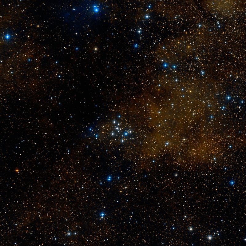
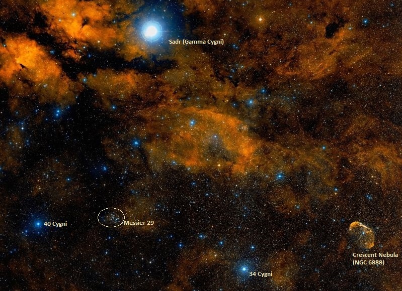
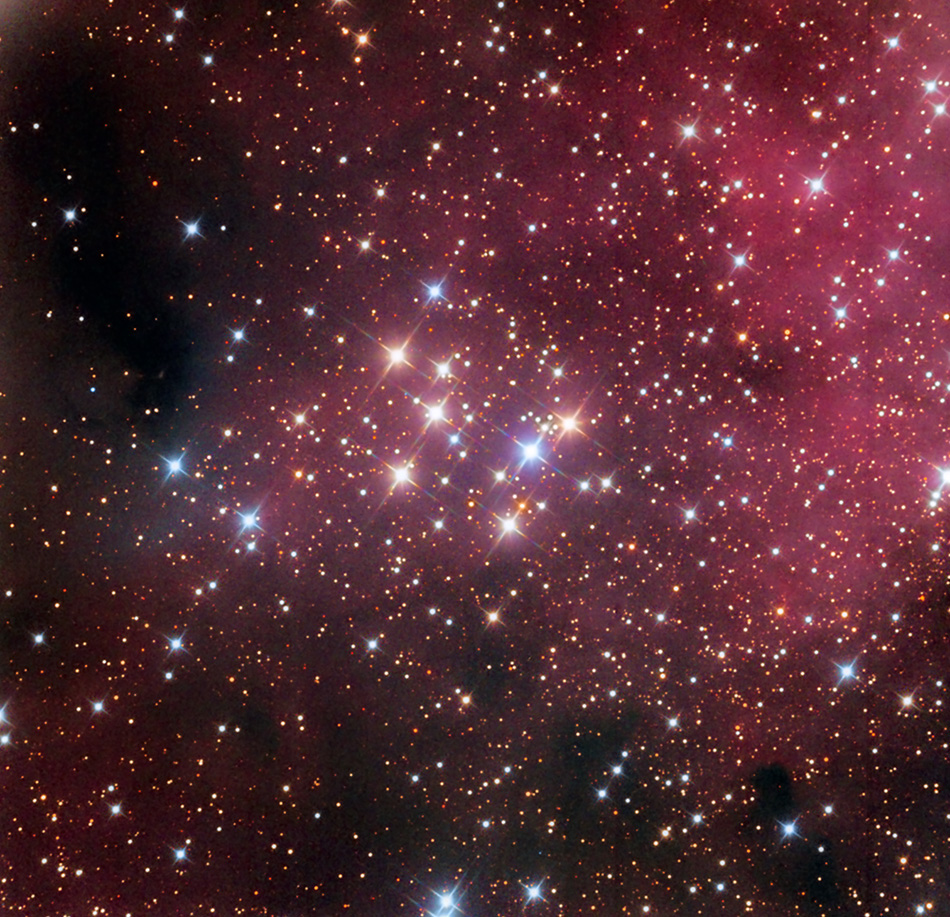
One of these objects is Messier 29, an open star cluster located in the northern skies in the direction of the Cygnus constellation. Situated in a highly crowded area of the Milky Way Galaxy, about 4,000 light-years from Earth, this star cluster is slowly moving towards us. Though somewhat isolated in the night sky, it can be easily spotted using binoculars and small telescopes.

Description:

While Messier Object 29 might appear a little bit boring compared to some of its more splashy catalog companions, it really isn’t. This little group of stars is part of the Cygnus OB1 association which just happens to be heading towards us at a speed of 28 kilometers per second (17.4 mps) . If it weren’t obscured by Milky Way dust, the light of its stars would be 1000 times brighter!

Messier 29 and Gamma Cygni (Sadr). Credit: Wikisky

All in all, M29 has around 50 member stars, but this 10 million year old star cluster still has some surprises. The five brightest stars you see are are all giant stars of spectral class B0, and if we were to put one next to our own Sol, it would shine 160,000 times brighter. Image just how “lit up” any planet might be that would reside inside that 11 light year expanse!

Astronomers were curious about Messier 29, too, so they went in search of binary stars. As C. Boeche (et al) wrote in a 2003 study:

“Between 1996 and 2003 we obtained 226 high resolution spectra of 16 stars in the field of the young open cluster NGC 6913, to constrain its main properties and study its internal kinematics. Twelve of the program stars turned out to be members, one of them probably unbound. Nine are binaries (one eclipsing and another double lined) and for seven of them the observations allowed us to derive the orbital elements. All but two of the nine discovered binaries are cluster members. In spite of the young age (a few Myr), the cluster already shows signs that could be interpreted as evidence of dynamical relaxatin and mass segregation.

“However, they may be also the result of an unconventional formation scenario. The dynamical (virial) mass as estimated from the radial velocity dispersion is larger than the cluster luminous mass, which may be explained by a combination of the optically thick interstellar cloud that occults part of the cluster, the unbound state or undetected very wide binary orbit of some of the members that inflate the velocity dispersion and a high inclination for the axis of possible cluster angular momentum. All the discovered binaries are hard enough to survive average close encounters within the cluster and do not yet show signs of relaxation of the orbital elements to values typical of field binaries.”

So why is finding binary stars important? Evolution is the solution, the hunt for Be stars. As S.L. Malchenko of the Crimean Astrophysical Observatory wrote in a 2008 study on Be stars:

“The phenomenon of Be stars has been known for over a century. The fact that at least 20% of B stars have an emission spectrum supports that the definition that this phenomenon is not special but it is rather typical from a large group of objects at a certain stage of evolution. The vagueness of the concept of the Be phenomenon suggests that this definition encompasses a broad group of objects near the main sequence that includes binary systems with different rate of mass exchange. This young open cluster in the Cyg OB1 association, is also know as M29, contains a large number of luminous stars with spectral types around B0. An extreme variation of extinction is found across the young open cluster NGC 6913, extinction in the cluster center is relatively homogeneous, but very large. We observed 10 spectra for 7 B stars and one known Be star in the blue region.”

Close-up of the core region of Messier 29. Credit: Adam Block/Mount Lemmon SkyCenter/University of Arizona

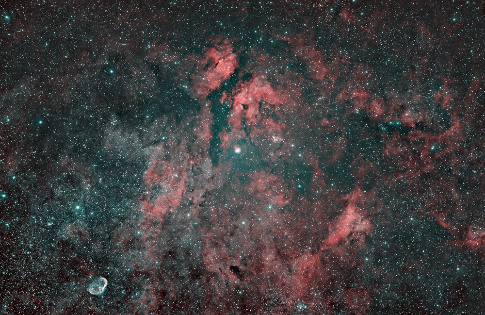
Although you won’t be able to detect it visually, there is also some nebulosity associated with M29, which is another important clue to this star cluster’s evolution. As B. Bhavya of Cochin University of Science and Technology wrote in a 2008 study:

“The Cygnus region is a region of recent star formation activity in the Milky Way and is rich in massive early type stars concentrated in OB associations. The presence of nebulosity and massive stars indicate that the stars have been forming till very recently and the young clusters found here are the result of the recent star formation event. Though the above fact is known, what is not known is that when this star formation process started and how it proceeded in the region. Though one assumes that all the stars in a cluster have the same age, this assumption is not valid when the candidate cluster is very young. In the case of young clusters, there is a chance for a spread in the age of the stars, depending on the duration of star formation. An estimation of this formation time-scale in the clusters formed in a star forming complex, will indicate the duration of star formation and its direction of propagation within the complex. In principle, duration of star formation is defined as the difference between the ages of the oldest and the youngest star formed in the cluster. In practice, the age of the oldest star is assumed as the age of that star which is about to turn-off from the main-sequence (MS) (turn-off age) and the age of the youngest star is the age of the youngest pre-MS star (turn-on age). The turn-off age of many clusters are known, but the turn-on age is not known for most of the clusters.”

History of Observation:

This cool little star cluster was an original discovery of Charles Messier, who first observed it in 1764. As he wrote of the object in his notes at the time:

“In the night of July 29 to 30, 1764, I have discovered a cluster of six or seven very small stars which are below Gamma Cygni, and which one sees with an ordinary refractor of 3 feet and a half in the form of a nebula. I have compared this cluster with the star Gamma, and I have determined its position in right ascension as 303d 54′ 29″, and its declination of 37d 11′ 57″ north.”

Gammy Cygni (the brightest object in the center) and neighboring regions. Credit: Wikipedia Commons/Erik Larsen

In the case of this cluster, it was independently recovered again by Caroline Herschel, who wrote: “About 1 deg under Gamma Cygni; in my telescope 5 small stars thus. My Brother looked at them with the 7 ft and counted 12. It is not in Mess. catalogue.”

William would also return to the cluster as well with his own observations: “Is not sufficiently marked in the heavens to deserve notice, as 7 or 8 small stars together are so frequent about this part of the heavens that one might find them by hundreds.”

So why the confusion? In this circumstance, perhaps Messier was a bit distracted, for it would appear that his logged coordinates were somewhat amiss. Leave it to Admiral Symth to set the records straight:

“A neat but small cluster of stars at the root of the Swan’s neck, and in the preceding branch of the Milky Way, not quite 2deg south of Gamma; and preceding 40 Cygni, a star of the 6th magnitude, by one degree just on the parallel. In the sp [south preceding, SW] portion are the two stars here estimated as double, of which A is 8, yellow; B 11, dusky. Messier discovered this in 1764; and though his description of it is very fair, his declination is very much out: worked up for my epoch it would be north 37d 26′ 15″. But one is only surprised that, with his confined methods and means, so much was accomplished.”

Kudos to Mr. Messier for being able to distinguish a truly related group of stars in a field of so many! Take the time to enjoy this neat little grouping for yourself and remember – it’s heading our way.

Locating Messier 29:

Finding M29 in binoculars or a telescope is quite easy once you recognize the constellation of Cygnus. Its cross-shape is very distinctive and the marker star you will need to locate this open star cluster is Gamma – bright and centermost. For most average binoculars, you will only need to aim at Gamma and you will see Messier 29 as a tiny grouping of stars that resembles a small box.

Messier 29 location. Image: IAU and Sky & Telescope magazine (Roger Sinnott & Rick Fienberg)
The location of Messier 29, in the direction of the Cygus constellation. Credit: IAU and Sky & Telescope magazine (Roger Sinnott & Rick Fienberg)

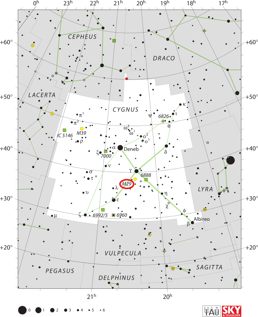
For a telescope, begin with your finderscope on Gamma, and look for your next starhop marker star about a finger width southwest. Once this star is near the center of your finderscope field, M29 will also be in a low magnification eyepiece field of view. Because it is a very widely spaced galactic open star cluster that only consists of a few stars, it makes an outstanding object that stands up to any type of sky conditions.

Except, of course, clouds! Messier 29 can easily be seen in light polluted areas and during a full Moon – making it a prize object for study for even the smallest of telescopes.

As always, here are the quick facts to help you get started:

Object Name: Messier 29
Alternative Designations: M29, NGC 6913
Object Type: Open Galactic Star Cluster
Constellation: Cygnus
Right Ascension: 20 : 23.9 (h:m)
Declination: +38 : 32 (deg:m)
Distance: 4.0 (kly)
Visual Brightness: 7.1 (mag)
Apparent Dimension: 7.0 (arc min)

We have written many interesting articles about Messier Objects here at Universe Today. Here’s Tammy Plotner’s Introduction to the Messier Objects, , M1 – The Crab Nebula, M8 – The Lagoon Nebula, and David Dickison’s articles on the 2013 and 2014 Messier Marathons.

Be to sure to check out our complete Messier Catalog. And for more information, check out the SEDS Messier Database.

Sources:

Merry Christmas From Space 2016

All six members of the Expedition 50 crew aboard the International Space Station celebrated the holidays together with a festive meal on Christmas Day, Dec. 25, 2016 Image Credit: NASA
All six members of the Expedition 50 crew aboard the International Space Station celebrated the holidays together with a festive meal on Christmas Day, Dec. 25, 2016  Image Credit: NASA
All six members of the Expedition 50 crew aboard the International Space Station celebrated the holidays together with a festive meal on Christmas Day, Dec. 25, 2016. Image Credit: NASA

As we celebrate the Christmas tidings of 2016 here on Earth, a lucky multinational crew of astronauts and cosmonauts celebrate the festive season floating in Zero-G while living and working together in space aboard the Earth orbiting International Space Station (ISS) complex – peacefully cooperating to benefit all humanity.

Today, Dec. 25, 2016, the six person Expedition 50 crew of five men and one woman marked the joyous holiday of Christ’s birth by gathering for a festive meal in space – as billions of Earthlings celebrated this Christmas season of giving, remembrance and peace to all here on our home planet.

This year is an especially noteworthy Space Christmas because it counts as Expedition 50. This is the 50th crew to reside on board since the space station began operating with permanent occupancy by rotating crews all the way back to 1998.

The Expedition 50 crew currently comprises of people from three nations supporting the ISS – namely the US, Russia and France; Commander Shane Kimbrough from NASA and flight engineers Andrey Borisenko (Roscosmos), Sergey Ryzhikov (Roscosmos), Thomas Pesquet (ESA), Peggy Whitson (NASA), and Oleg Novitskiy (Roscosmos).

Here a short video of holiday greetings from a trio of crew members explaining what Christmas in Space means to them:

Video Caption: Space Station Crew Celebrates the Holidays Aboard the Orbital Lab. Aboard the International Space Station, Expedition 50 Commander Shane Kimbrough and Peggy Whitson of NASA and Thomas Pesquet of the European Space Agency discussed their thoughts about being in space during the holidays and how they plan to celebrate Christmas and New Year’s in a downlink. Credit: NASA

“Hello from the Expedition 50 Crew! We’d like to share what Christmas means to us,” said Expedition 50 Commander Shane Kimbrough.

“For me it’s a lot about family,” said Expedition 50 Commander Shane Kimbrough. “We always travel to meet up with our family which is dispersed across the country. And we go home to Georgia and Florida … quite abit to meet up. Always a great time to get together and share with each other.”

“Although its typically thought of a season to get things, we in our family think about the giving aspect. Giving of our many talents and resources. Especially to those less fortunate.”

Kimbrough arrived on the complex in October, followed a month later by Whitson and Pesquet in November.

They were all launched aboard Russian Soyuz capsules from the Baikonur Cosmodrome in Kazakhstan.

Aboard the International Space Station, Expedition 50 Flight Engineer Peggy Whitson of NASA sent holiday greetings and festive imagery from the cupola on Dec. 18, 2016. Credit: NASA.

And Peggy Whitson especially has a lot to celebrate in space!

Because not only is Whitson currently enjoying her third long-duration flight aboard the station – as an Expedition 50 flight engineer. Soon she will become the first woman to command the station twice ! That momentous event happens when she assumes the role of Space Station Commander early in 2017 during the start of Expedition 51.

“In addition to family, there is another very important aspect to being on the ISS,” said Whitson.

“That is seeing the planet as a whole. It actually reinforces I think, that fact that we should live as one people and strive for peace.”

“I second the comments already made. I grew up in a family of 25 cousins,” said ESA’s Thomas Pesquet. “The only time we could catch up was around Christmas time…. So I always looked forward to that, although this year I can’t be with them of course … and will think of them.”

“I am making the most of this opportunity to look at the Earth. Reflect about what Christmas means to us as individuals and to the world in general. And we will have a good time on board the ISS and share a Christmas meal together.”

Aboard the International Space Station, Expedition 50 Flight Engineer Peggy Whitson of NASA sent holiday greetings and festive imagery from the Japanese Kibo laboratory module on Dec. 18, 2016. Credit: NASA

The crew is enjoying a light weekend of work and a day off tomorrow, Dec. 26.

After that they begin preparing for a pair of spacewalks in the new year by Kimbrough and Whitson – scheduled for Jan. 6 and 13. The crew is checking the spacesuits by testing the water among other activities.

The goal of the excursions is to “complete the replacement of old nickel-hydrogen batteries with new lithium-ion batteries on the station’s truss structure,” says NASA.

Research work also continues.

“Whitson, who is spending her second Christmas in space, and Pesquet drew blood, urine and saliva samples for the Fluid Shifts study. That experiment investigates the upward flow of body fluids in space potentially causing lasting vision changes in astronauts.”

NASA astronaut Peggy Whitson floats through the Unity module aboard the International Space Station. On her third long-duration flight aboard the station, Whitson will become the first woman to command the station twice when she assumes the role during Expedition 51. Credit: NASA

Among other activities, the crew is also unloading 4.5 tons of internal and external cargo, gear and fresh food – including six lithium-ion batteries – from Japan’s sixth H-II Transfer Vehicle (HTV-6), which recently arrived at the ISS on Dec 13.

The next regular US cargo delivery is likely to be in March 2017, when an unmanned Orbital ATK Cygnus cargo freighter is slated to launch on a ULA Atlas V from Cape Canaveral. A Cygnus was also launched on a ULA Atlas V in March 2016.

A Cygnus cargo spacecraft named the SS Rick Husband is being prepared inside the Payload Hazardous Servicing Facility at NASA’s Kennedy Space Center for upcoming Orbital ATK CRS-6/OA-6 mission to deliver hardware and supplies to the International Space Station. Cygnus is scheduled to lift off atop a United Launch Alliance Atlas V rocket on March 22, 2016. Credit: Ken Kremer/kenkremer.com

SpaceX also hopes to resume Dragon cargo launches sometime in the new year after they resolve the issues that led to the destruction of a SpaceX Falcon 9 on Sept. 1 during fueling operations at pad 40 on the Cape.

Meanwhile Roscosmos continues to investigate the causes of the failed launch of the unmanned Russian Progress 65 resupply ship on Dec. 1 due to a 3rd stage anomaly.

Stay tuned here for Ken’s continuing Earth and Planetary science and human spaceflight news.

Ken Kremer

See a Christmas-Time Binocular Comet: 45P/Honda-Mrkos-Pajdusakova

45P/H-M-P displays a colorful coma and long ion tail on Dec. 22, 2016. Credit: Gerald Rhemann
Comet 45P/Honda-Mrkos-Pajdusakova captured in its glory on Dec. 22, 2016. It displays a bright, well-condensed blue-green coma and long ion tail pointing east. Credit: Gerald Rhemann
Comet 45P/Honda-Mrkos-Pajdusakova captured in its glory on Dec. 22, 2016. It displays a bright, well-condensed blue-green coma and long ion or gas tail pointing east. Comet observers take note: a Swan Band filter shows a larger coma and increases the comet’s contrast. Credit: Gerald Rhemann

Merry Christmas and Happy Holidays all! I hope the day finds you in the company of family or friends and feeling at peace. While we’ve been shopping for gifts the past few weeks, a returning comet has been brightening up in the evening sky. Named 45P/Honda-Mrkos-Pajdusakova, it returns to the hood every 5.25 years after vacationing beyond the planet Jupiter. It’s tempting to blow by the name and see only a jumble of letters, but let’s try to pronounce it: HON-da — MUR-Koz — PIE-doo-sha-ko-vah. Not too hard, right?

Tonight, the comet will appear about 12. 5 degrees to the west of Venus in central Capricornus. You can spot it near the end of evening twilight. Use larger binoculars or a telescope. Stellarium

Comet 45P is a short period comet — one with an orbital period of fewer than 200 years — discovered on December 3, 1948 by Minoru Honda along with co-discoverers Antonin Mrkos and Ludmila Pajdusakova. Three names are the maximum a comet can have even if 15 people simultaneously discover it. 45P has a history of brightening rapidly as it approaches the sun, and this go-round is proof. A faint nothing a few weeks back, the comet’s now magnitude +7.5 and visible in 50mm or larger binoculars from low light pollution locations.

You can catch it right around the end of dusk this week and next as it arcs across central Capricornus not far behind the brilliant planet Venus. 45P will look like a dim, fuzzy star in binoculars, but if you can get a telescope on it, you’ll see a fluffy, round coma, a bright, star-like center and perhaps even a faint spike of a tail sticking out to the east. Time exposure photos reveal a tail at least 3° long and a gorgeous, aqua-tinted coma. I saw the color straight off when observing the comet several nights ago in my 15-inch reflector at low power (64x).

Use this map to help you follow the comet night to night. Tick marks start this evening (Dec. 25) and show its nightly position through Jan. 8. Venus, at upper left, is shown through the 28th. Created with Chris Marriott's SkyMap software
Use this map to help you follow the comet night to night. Tick marks start this evening (Dec. 25) and show its nightly position through Jan. 8 around 6 p.m. local time or about an hour and 15 minutes after sunset. Venus, at upper left, is shown through the 28th with stars to magnitude +7. Click the chart for a larger version you can save and print out for use at your telescope. Created with Chris Marriott’s SkyMap software

Right now, and for the remainder of its evening apparition, 45P will never appear very high in the southwestern sky. Look for it a little before the end of evening twilight, when the sky is reasonably dark and the comet is as high as it gets — about a fist above the horizon as seen from mid-northern latitudes. That’s pretty low, so make the best of your time. I recommend you being around 1 hour 15 minutes after sunset.

The further south you live, the higher 45P will appear. To a point. It hovers low at nightfall this month and next. That will change in February when the comet pulls away from the sun and makes a very close approach to the Earth while sailing across the morning sky.

How about a helping hand? On New Year's Eve, the 2-day-old crescent Moon will be just a few degrees from 45P. This simulation shows the view through 50mm or larger binoculars with an ~6 degree field of view. Map: Bob King, Source: Stellarium
How about a helping hand? On New Year’s Eve, the 2-day-old crescent Moon will be just a few degrees from 45P. This simulation shows the view through 50mm or larger binoculars with an ~6 degree field of view for the Central time zone. Map: Bob King, Source: Stellarium

45P reaches perihelion or closest distance to the sun on Dec. 31 and will remain visible through about Jan. 15 at dusk. An approximately 2-week hiatus follows, when it’s lost in the twilight glow. Then in early February, the comet reappears at dawn and races across Aquila and Hercules, zipping closest to Earth on Feb. 11 at a distance of only 7.7 million miles. During that time, we may even be able to see this little fuzzball with the naked eye; its predicted magnitude of +6 at maximum is right at the naked eye limit. Even in suburban skies, it will make an easy catch in binoculars then.

I’ll update with new charts as we approach that time, plus you can check out this earlier post by fellow Universe Today writer David Dickinson. For now, enjoy the prospect of ‘opening up’ this cometary gift as the last glow of dusk subsides into night.

The Canis Minor Constellation

View of the night sky in North Carolina, showing the constellations of Orion, Hyades, Canis Major and Canis Minor. Credit: NASA

Welcome back to Constellation Friday! Today, in honor of the late and great Tammy Plotner, we will be dealing with the “little dog” – the Canis Minor constellation!

In the 2nd century CE, Greek-Egyptian astronomer Claudius Ptolemaeus (aka. Ptolemy) compiled a list of all the then-known 48 constellations. This treatise, known as the Almagest, would be used by medieval European and Islamic scholars for over a thousand years to come, effectively becoming astrological and astronomical canon until the early Modern Age.

One of these constellations was Canis Minor, a small constellation in the northern hemisphere. As a relatively dim collection of stars, it contains only two particularly bright stars and only faint Deep Sky Objects. Today, it is one of the 88 constellations recognized by the International Astronomical Union, and is bordered by the Monoceros, Gemini, Cancer and Hydra constellation.

Name and Meaning:

Like most asterisms named by the Greeks and Romans, the first recorded mention of this constellation goes back to ancient Mesopotamia. Specifically, Canis Minor’s brightest stars – Procyon and Gomeisa – were mentioned in the Three Stars Each tablets (ca. 1100 BCE), where they were referred to as MASH.TAB.BA (or “twins”).

The Winter Hexagon, which contains parts of the Auriga, Canis Major, Canis Minor, Gemini, Monoceros, Orion, Taurus, Lepus and Eridanus constellations. Credit: constellation-guide.com

In the later texts that belong to the MUL.APIN, the constellation was given the name DAR.LUGAL (“the star which stands behind it”) and represented a rooster. According to ancient Greco-Roman mythology, Canis Minor represented the smaller of Orion’s two hunting dogs, though they did not recognize it as its own constellation.

In Greek mythology, Canis Minor is also connected with the Teumessian Fox, a beast turned into stone with its hunter (Laelaps) by Zeus. He then placed them in heaven as Canis Major (Laelaps) and Canis Minor (Teumessian Fox). According to English astronomer and biographer of constellation history Ian Ridpath:

“Canis Minor is usually identified as one of the dogs of Orion. But in a famous legend from Attica (the area around Athens), recounted by the mythographer Hyginus, the constellation represents Maera, dog of Icarius, the man whom the god Dionysus first taught to make wine. When Icarius gave his wine to some shepherds for tasting, they rapidly became drunk. Suspecting that Icarius had poisoned them, they killed him. Maera the dog ran howling to Icarius’s daughter Erigone, caught hold of her dress with his teeth and led her to her father’s body. Both Erigone and the dog took their own lives where Icarius lay.

“Zeus placed their images among the stars as a reminder of the unfortunate affair. To atone for their tragic mistake, the people of Athens instituted a yearly celebration in honour of Icarius and Erigone. In this story, Icarius is identified with the constellation Boötes, Erigone is Virgo and Maera is Canis Minor.”

Canis Minor, as depicted by Johann Bode in his 1801 work Uranographia. Credit: Wikipedia Commons/Alessio Govi

To the ancient Egyptians, this constellation represented Anubis, the jackal god. To the ancient Aztecs, the stars of Canis Minor were incorporated along with stars from Orion and Gemini into as asterism known as “Water”, which was associated with the day. Procyon was also significant in the cultural traditions of the Polynesians, the Maori people of New Zealand, and the Aborigines of Australia.

In Chinese astronomy, the stars corresponding to Canis Minor were part of the The Vermilion Bird of the South. Along with stars from Cancer and Gemini, they formed the asterisms known as the Northern and Southern River, as well as the asterism Shuiwei (“water level”), which represented an official who managed floodwaters or a marker of the water level.

History of Observation:

Canis Minor was one of the original 48 constellations included by Ptolemy in his the Almagest. Though not recognized as its own asterism by the Ancient Greeks, it was added by the Romans as the smaller of Orion’s hunting dogs. Thanks to Ptolemy’s inclusion of it in his 2nd century treatise, it would go on to become part of astrological and astronomical traditions for a thousand years to come.

For medieval Arabic astronomers, Canis Minor continued to be depicted as a dog, and was known as “al-Kalb al-Asghar“. It was included in the Book of Fixed Stars by Abd al-Rahman al-Sufi, who assigned a canine figure to his stellar diagram. Procyon and Gomeisa were also named for their proximity to Sirius; Procyon being named the “Syrian Sirius (“ash-Shi’ra ash-Shamiya“) and Gomeisa the “Sirius with bleary eyes” (“ash-Shira al-Ghamisa“).

Monoceros and the obsolete constellation Atelier Typographique. Credit: Library of Congress
The constellation Canis Minor, shown alongside Monoceros and the obsolete constellation Atelier Typographique. Credit: Library of Congress

The constellation was included in Syndey Hall’s Urania’s Mirror (1825) alongside Monoceros and the now obsolete constellation Atelier Typographique. Many alternate names were suggested between the 17th and 19th centuries in an attempt to simplify celestial charts. However, Canis Minor has endured; and in 1922, it became one the 88 modern constellations to be recognized by the IAU.

Notable Features:

Canis Minor contains two primary stars and 14 Bayer/Flamsteed designated stars. It’s brightest star, Procyon (Alpha Canis Minoris), is also the seventh brightest star in the sky. With an apparent visual magnitude of 0.34, Procyon is not extraordinarily bright in itself. But it’s proximity to the Sun – 11.41 light years from Earth – ensures that it appears bright in the night sky.

The star’s name is derived from the Greek word which means “before the dog”, a reference to the fact that it appears to rise before Sirius (the “Dog Star”) when observed from northern latitudes. Procyon is a binary star system, composed of a white main sequence star (Procyon A) and Procyon B, a DA-type faint white dwarf as the companion.

Procyon is part of the Winter Triangle asterism, along with Sirius in Canis Major and Betelgeuse in the constellation Orion. It is also part of the Winter Hexagon, along with the stars Capella in Auriga, Aldebaran in Taurus, Castor and Pollux in Gemini, Rigel in Orion and Sirius in Canis Major.

The stars of the Winter Triangle and the Winter Hexagon. Credit: constellation-guide.com

Next up is Gomeisa, the second brightest star in Canis Minor. This hot, B8-type main sequence star is classified as a Gamma Cassiopeiae variable, which means that it rotates rapidly and exhibits irregular variations in luminosity because of the outflow of matter. Gomeisa is approximately 170 light years from Earth and the name is derived from the Arabic “al-ghumaisa” (the bleary-eyed woman”).

Canis Minor also has a number of Deep Sky Objects located within it, but all are very faint and difficult to observe. The brightest is the spiral galaxy NGC 2485 (apparent magnitude of 12.4), which is located 3.5 degrees northeast of Procyon. There is one meteor shower associated with this constellation, which are the Canis-Minorids.

Finding Canis Minor:

Though it is relatively faint, Canis Minor and its stars can be viewed using binoculars. Start with the brightest, Procyon – aka. Alpha Canis Minoris (Alpha CMi). If you’re unsure of which bright star is, you’ll find it in the center of the diamond shape grouping in the southwest area. Known to the ancients as Procyon – “The Little Dog Star” – it’s the seventh brightest star in the night sky and the 13th nearest to our solar system.

For over 100 years, astronomers have known this brilliant star had a companion. Being 15,000 times fainter than the parent star, Procyon B is an example of a white dwarf whose diameter is only about twice that of Earth. But its density exceeds two tons per cubic inch! (Or, a third of a metric ton per cubic centimeter). While only very large telescopes can resolve this second closest of the white dwarf stars, even the moonlight can’t dim its beauty.

The Winter Triangle. Credit: constellation-guide.com/Stellarium software

Now hop over to Beta CMi. Known by the very strange name of Gomeisa (“bleary-eyed woman”), it refers to the weeping sister left behind when Sirius and Canopus ran to the south to save their lives. Located about 170 light years away from our Solar System, Beta is a blue-white class B main sequence dwarf star with around 3 times the mass of our Sun and a stellar luminosity over 250 times that of Sol.

Gomeisa is a fast rotator, spinning at its equator with a speed of at least 250 kilometers per second (125 times our  Sun’s rotation speed) giving the star a rotation period of about a day. Sunspots would appear to move very quickly there! According to Jim Kaler, Professor Emeritus of Astronomy at the University of Illinois:

“Since we may be looking more at the star’s pole than at its equator, it may be spinning much faster, and indeed is rotating so quickly that it is surrounded by a disk of matter that emits radiation, rendering Gomeisa a “B-emission” star rather like Gamma Cassiopeiae and Alcyone. Like these two, Gomeisa is distinguished by having the size of its disk directly measured, the disk’s diameter almost four times larger than the star. Like quite a number of hot stars (including Adhara, Nunki, and many others), Gomeisa is also surrounded by a thin cloud of dusty interstellar gas that it helps to heat.”

Now hop over to Gamma Canis Minoris, an orange K-type giant with an apparent magnitude of +4.33. It is a spectroscopic binary, has an unresolved companion which has an orbital period of 389 days, and is approximately 398 light years from Earth. And next is Epsilon Canis Minoris, a yellow G-type bright giant (apparent magnitude of +4.99) which is approximately 990 light years from Earth.

The location of Canis Minor in the northern hemisphere. Credit: IAU/Sky&Telescope magazine

For smaller telescopes, the double star Struve 1149 is a lovely sight, consisting of a yellow primary star and a faintly blue companion. For larger telescopes and GoTo telescopes, try NGC 2485 (RA 07 56.7 Dec +07 29), a magnitude 13 spiral galaxy that has a small, round glow, sharp edges and a very bright, stellar nucleus. If you want one that’s even more challenging, try NGC 2508 (RA 08 02 0 Dec +08 34).

Canis Minor lies in the second quadrant of the northern hemisphere (NQ2) and can be seen at latitudes between +90° and -75°. The neighboring constellations are Cancer, Gemini, Hydra, and Monoceros, and it is best visible during the month of March.

We have written many interesting articles about the constellation here at Universe Today. Here is What Are The Constellations?What Is The Zodiac?, and Zodiac Signs And Their Dates.

Be sure to check out The Messier Catalog while you’re at it!

For more information, check out the IAUs list of Constellations, and the Students for the Exploration and Development of Space page on Canes Venatici and Constellation Families.

Sources:

How Do We Settle on Saturn’s Moons?

A collage of Saturn (bottom left) and some of its moons: Titan, Enceladus, Dione, Rhea and Helene. Credit: NASA/JPL/Space Science Institute

Welcome back to our series on Settling the Solar System! Today, we take a look at the largest of Saturn’s Moons – Titan, Rhea, Iapetus, Dione, Tethys, Enceladus, and Mimas.

From the 17th century onward, astronomers made some profound discoveries around the planet Saturn, which they believed was the most distant planet of the Solar System at the time. Christiaan Huygens and Giovanni Domenico Cassini were the first, spotting the largest moons of Saturn – Titan, Tethys, Dione, Rhea and Iapetus. More discoveries followed; and today, what we recognized as the Saturn system includes 62 confirmed satellites.

What we know of this system has grown considerably in recent decades, thanks to missions like Voyager and Cassini. And with this knowledge has come multiple proposals that claim how Saturn’s moons should someday be colonized. In addition to boasting the only body other than Earth to have a dense, nitrogen-rich atmosphere, there are also abundant resources in this system that could be harnessed.

Much like the idea of colonizing the Moon, Mars, the moons of Jupiter, and other bodies in the Solar System, the idea of establishing colonies on Saturn’s moons has been explored extensively in science fiction. At the same time, scientific proposals have been made that emphasize how colonies would benefit humanity, allowing us to mount missions deeper into space and ushering in an age of abundance!

A montage of images from Cassini of various moons and the rings around Saturn. Credit: NASA/JPL-Caltech/Space Science Institute

Examples in Fiction:

The colonization of Saturn has been a recurring theme in science fiction over the decades. For example, in Arthur C. Clarke’s 1976 novel Imperial Earth, Titan is home to a human colony of 250,000 people. The colony plays a vital role in commerce, where hydrogen is taken from the atmosphere of Saturn and used as fuel for interplanetary travel.

In Piers Anthony’s Bio of a Space Tyrant series (1983-2001), Saturn’s moons have been colonized by various nations in a post-diaspora era. In this story, Titan has been colonized by the Japanese, whereas Saturn has been colonized by the Russians, Chinese, and other former Asian nations.

In the novel Titan (1997) by Stephen Baxter, the plot centers on a NASA mission to Titan which must struggle to survive after crash landing on the surface. In the first few chapters of Stanislaw Lem’s Fiasco (1986), a character ends up frozen on the surface of Titan, where they are stuck for several hundred years.

In Kim Stanley Robinson’s Mars Trilogy (1996), nitrogen from Titan is used in the terraforming of Mars. In his novel 2312 (2012), humanity has colonized several of Saturn’s moons, which includes Titan and Iapetus. Several references are made to the “Enceladian biota” in the story as well, which are microscopic alien organisms that some humans ingest because of their assumed medicinal value.

The moons of Saturn, from left to right: Mimas, Enceladus, Tethys, Dione, Rhea; Titan in the background; Iapetus (top) and irregularly shaped Hyperion (bottom). Some small moons are also shown. All to scale. Credit: NASA/JPL/Space Science Institute
The moons of Saturn, from left to right: Mimas, Enceladus, Tethys, Dione, Rhea; Titan in the background; Iapetus (top) and irregularly shaped Hyperion (bottom). Credit: NASA/JPL/Space Science Institute

As part of his Grand Tour Series, Ben Bova’s novels Saturn (2003) and Titan (2006) address the colonization of the Cronian system. In these stories, Titan is being explored by an artificially intelligent rover which mysteriously begins malfunctioning, while a mobile human Space Colony explores the Rings and other moons.

Proposed Methods:

In his book Entering Space: Creating a Spacefaring Civilization (1999), Robert Zubrin advocated colonizing the outer Solar System, a plan which included mining the atmospheres of the outer planets and establishing colonies on their moons. In addition to Uranus and Neptune, Saturn was designated as one of the largest sources of deuterium and helium-3, which could drive the pending fusion economy.

He further identified Saturn as being the most important and most valuable of the three, because of its relative proximity, low radiation, and excellent system of moons. Zubrin claimed that Titan is a prime candidate for colonization because it is the only moon in the Solar System to have a dense atmosphere and is rich in carbon-bearing compounds.

On March 9th, 2006, NASA’s Cassini space probe found possible evidence of liquid water on Enceladus, which was confirmed by NASA in 2014. According to data derived from the probe, this water emerges from jets around Enceladus’ southern pole, and is no more than tens of meters below the surface in certain locations. This would would make collecting water considerably easier than on a moon like Europa, where the ice sheet is several km thick.

Data obtained by Cassini also pointed towards the presence of volatile and organic molecules. And Enceladus also has a higher density than many of Saturn’s moons, which indicates that it has a larger average silicate core. All of these resources would prove very useful for the sake of constructing a colony and providing basic operations.

In October of 2012, Elon Musk unveiled his concept for an Mars Colonial Transporter (MCT), which was central to his long-term goal of colonizing Mars. At the time, Musk stated that the first unmanned flight of the Mars transport spacecraft would take place in 2022, followed by the first manned MCT mission departing in 2024.

In September 2016, during the 2016 International Astronautical Congress, Musk revealed further details of his plan, which included the design for an Interplanetary Transport System (ITS) and estimated costs. This system, which was originally intended to transport settlers to Mars, had evolved in its role to transport human beings to more distant locations in the Solar System – which could include the Jovian and Cronian moons.

Artist's rendering of possible hydrothermal activity that may be taking place on and under the seafloor of Enceladus. Image Credit: NASA/JPL
Artist’s rendering of possible hydrothermal activity that may be taking place on and under the seafloor of Enceladus. Credit: NASA/JPL

Potential Benefits:

Compared to other locations in the Solar System – like the Jovian system – Saturn’s largest moons are exposed to considerably less radiation. For instance, Jupiter’s moons of Io, Ganymede and Europa are all subject to intense radiation from Jupiter’s magnetic field – ranging from 3600 to 8 rems day. This amount of exposure would be fatal (or at least very hazardous) to human beings, requiring that significant countermeasures be in place.

In contrast, Saturn’s radiation belts are significantly weaker than Jupiter’s – with an equatorial field strength of 0.2 gauss (20 microtesla) compared to Jupiter’s 4.28 gauss (428 microtesla). This field extends from about 139,000 km from Saturn’s center out to a distance of about 362,000 km – compared to Jupiter’s, which extends to a distance of about 3 million km.

Of Saturn’s largest moons, Mimas and Enceladus fall within this belt, while Dione, Rhea, Titan, and Iapetus all have orbits that place them from just outside of Saturn’s radiation belts to well beyond it. Titan, for example, orbits Saturn at an average distance (semi-major axis) of 1,221,870 km, putting it safely beyond the reach of the gas giant’s energetic particles. And its thick atmosphere may be enough to shield residents from cosmic rays.

In addition, frozen volatiles and methane harvested from Saturn’s moons could be used for the sake of terraforming other locations in the Solar System. In the case of Mars, nitrogen, ammonia and methane have been suggested as a means of thickening the atmosphere and triggering a greenhouse effect to warm the planet. This would cause water ice and frozen CO² at the poles to sublimate – creating a self-sustaining process of ecological change.

Colonies on Saturn’s moons could also serve as bases for harvesting deuterium and helium-3 from Saturn’s atmosphere. The abundant sources of water ice on these moons could also be used to make rocket fuel, thus serving as stopover and refueling points. In this way, a colonizing the Saturn system could fuel Earth’s economy, and the facilitate exploration deeper into the outer Solar System.

Challenges:

Naturally, there are numerous challenges to colonizing Saturn’s moons. These include the distance involved, the necessary resources and infrastructure, and the natural hazards colonies on these moons would have to deal with. For starters, while Saturn may be abundant in resources and closer to Earth than either Uranus or Neptune, it is still very far.

On average, Saturn is approximately 1,429 billion km away from Earth; or ~8.5 AU, the equivalent of eight and a half times the average distance between the Earth and the Sun. To put that in perspective, it took the Voyager 1 probe roughly thirty-eight months to reach the Saturn system from Earth. For crewed spacecraft, carrying colonists and all the equipment needed to colonize the surface, it would take considerably longer to get there.

These ships, in order to avoid being overly large and expensive, would need to rely on cryogenics or hibernation-related technology in order to save room on storage and accommodations. While this sort of technology is being investigated for crewed missions to Mars, it is still very much in the research and development phase.

Artist's concept of a Bimodal Nuclear Thermal Rocket in Low Earth Orbit. Credit: NASA
Artist’s concept of a Bimodal Nuclear Thermal Rocket in Low Earth Orbit. Credit: NASA

Any vessels involved in the colonization efforts, or used to ship resources to and from the Cronian system, would also need to have advanced propulsion systems to ensure that they could make the trips in a realistic amount of time. Given the distances involved, this would likely require rockets that used nuclear-thermal propulsion, or something even more advanced (like anti-matter rockets).

And while the former is technically feasible, no such propulsion systems have been built just yet. Anything more advanced would require many more years of research and development, and a major commitment in resources. All of this, in turn, raises the crucial issue of infrastructure.

Basically, any fleet operating between Earth and Saturn would require a network of bases between here and there to keep them supplied and fueled. So really, any plans to colonize Saturn’s moons would have to wait upon the creation of permanent bases on the Moon, Mars, the Asteroid Belt, and most likely the Jovian moons. This process would be punitively expensive by current standards and (again) would require a fleet of ships with advanced drive systems.

And while radiation is not a major threat in the Cronian system (unlike around Jupiter), the moons have been subject to a great deal of impacts over the course of their history. As a result, any settlements built on the surface would likely need additional protection in orbit, like a string of defensive satellites that could redirect comets and asteroids before they reached orbit.

 The huge storm churning through the atmosphere in Saturn's northern hemisphere overtakes itself as it encircles the planet in this true-color view from NASA’s Cassini spacecraft. Image credit: NASA/JPL-Caltech/SSI
The huge storm churning through the atmosphere in Saturn’s northern hemisphere overtakes itself as it encircles the planet in this true-color view from NASA’s Cassini spacecraft. Image credit: NASA/JPL-Caltech/SSI

Given its abundant resources, and the opportunities it would present for exploring deeper into the Solar System (and maybe even beyond), Saturn and its system of moons is nothing short of a major prize. On top of that, the prospect of colonizing there is a lot more appealing than other locations that come with greater hazards (i.e. Jupiter’s moons).

However, such an effort would be daunting and would require a massive multi-generational commitment. And any such effort would most likely have to wait upon the construction of colonies and/or bases in locations closer to Earth first – such as on the Moon, Mars, the Asteroid Belt, and around Jupiter. But we can certainly hold out hope for the long run, can’t we?

We have written many interesting articles on colonization here at Universe Today. Here’s Why Colonize the Moon First?, How Do We Colonize Mercury?, How Do We Colonize Venus?, Colonizing Venus with Floating Cities, Will We Ever Colonize Mars?, How Do We Colonize Jupiter’s Moons?, and The Definitive Guide to Terraforming.

Astronomy Cast also has many interesting episodes on the subject. Check out Episode 59: Saturn, Episode 61: Saturn’s Moons, Episode 95: Humans to Mars, Part 2 – Colonists, Episode 115: The Moon, Part 3 – Return to the Moon, and Episode 381: Hollowing Asteroids in Science Fiction.

Sources:

Hubble Spots Festive Nebula in Neighboring Galaxy

Hubble image of NGC 248, two nebulas located in the Small Magellanic Cloud. Credit: NASA, ESA, STScI, K. Sandstrom/SMIDGE team

The Hubble Space Telescope has revealed some amazing things over the past few decades. Over the course of its many missions, this orbiting observatory has spotted things ranging from distant stars and galaxies to an expanding Universe. And today, twenty-six years later, it is still providing us with rare glimpses of the cosmos.

For example, just in time for the holidays, Hubble has released images of two rosy, glowing nebulas in the Small Magellanic Cloud (SMC). These glowing clouds of gas and dust were spotted as part of a study known as the Small Magellanic Cloud Investigation of Dust and Gas Evolution (SMIDGE), an effort to study this neighboring galaxy in an attempt to better understand our own.

The images were taken by Hubble’s Advanced Camera for Surveys (ACS) in September 2015 and feature NGC 248 – two gaseous nebulas that were first observed by astronomer Sir John Herschel in 1834 and are situated in such a way as to appear as one. Measuring about 60 light years in length and 20 light-years in width, these nebulas are among a series of emission nebulas located in the neighboring dwarf satellite galaxy.

Small and Large Magellanic Clouds over Paranal Observatory Credit: ESO/J. Colosimo

Emission nebulas are essentially large clouds of ionized gases that emit light of various colors – in this case, bright red. The color and luminosity of NGC 248 is due to the nebulas heavy hydrogen content, and the fact that they have young, brilliant stars at the center of them. These stars emit intense radiation that heats up the hydrogen gas, causing it to emit bright red light.

As noted, the images were taken as part of the SMIDGE study, an effort on behalf of astronomers to probe the Milky Way satellite – which is located approximately 200,000 light-years away in the southern constellation Tucana – using the Hubble Space Telescope. The ultimate goal of this study is to understand how dust is different in galaxies that have a far lower supply of the heavy elements needed to create it.

In the case of the SMC, it has between one-fifth and one-tenth the amount of heavy metals as the Milky Way. In addition, its proximity to the Milky Way makes it a convenient target for astronomers who are looking to better understand the history of the earlier Universe. Essentially, most star formation in the Milky Way happened at a time when the amount of heavy elements was much lower than it is now.

This ground-based image shows the Small Magellanic Cloud. The area of the SMIDGE survey is highlighted, as well as the position of NGC 248. Image credit: NASA / ESA / Hubble / Digitized Sky Survey 2.
Ground-based image of the Small Magellanic Cloud. showing the area of the SMIDGE survey and the position of NGC 248. Credit: NASA/ESA/Hubble/Digitized Sky Survey 2

According to Dr. Karin Sandstrom, a professor from the University of California and the principle investigator of SMIDGE, studying the SMC’s can tell us much about neighboring galaxies, but also about the evolution  of the Milky Way. “It is important for understanding the history of our own galaxy, too,” he said. “Dust is a really critical part of how a galaxy works, how it forms stars.”

In addition to the stunning images, the SMIDGE team and the Space Telescope Science Institute have also produced a video that shows the location of NGC 248 in the southern sky. As you can see, the video begins with a ground-based view of the night sky (from the southern hemisphere) and then zooms in on the Small Magellanic Cloud, emphasizing the field where NGC 249 appears.

Check out the video below, and have yourselves a Merry Christmas and some Happy Holidays!

Further Reading: NASA

Spiders Growing on the Surface of Mars Right Before Our Eyes!

Artist's impression of geysers at the Martian south polar icecap as southern spring begins. Credit: NASA/JPL-Caltech/Arizona State University/Ron Miller

For years, scientists have understood that in Mars’ polar regions, frozen carbon dioxide (aka. dry ice) covers much of the surface during the winter. During the spring, this ice sublimates in places, causing the ice to crack and jets of CO² to spew forth. This leads to the formation of dark fans and features known as “spiders”, both of which are unique to Mars’ southern polar region.

For the past decade, researchers have failed to see these features changing from year-to-year, where repeated thaws have led to their growth. However, using data from the Mars Reconnaissance Orbiter‘s (MRO) HiRISE camera, a research team from the University of Colorado, Boulder and the Planetary Science Institute in Arizona have managed to catch sight of the cumulative growth of a spider for the first time from one spring to the next.

Spiders are so-named because of their appearance, where multiple channels converge on a central pit. Dark fans, on the other hand, are low-albedo patches that are darker than the surrounding ice sheet. For some time, astronomers have been observed these features in the southern polar region of Mars, and multiple theories were advanced as to their origin.

mars-landscape-araneiforms-fans-pia21258-br2
HiRISE images of the Martian landscape, showing outgassing and the formation of dark fans and “spiders”. Credit: NASA/JPL

In 2007, Hugh Kieffer of the Space Science Institute in Boulder, Colorado theorized that the dark fans and spiders were linked, and that both features were the result of spring thaws. In short, during Mars’ spring season – when the southern polar region is exposed to more sunlight – the Sun’s rays penetrates the ice sheets and warm the ground underneath.

This causes gas flows to form beneath the ice that build up pressure, eventually causing the ice to crack and triggering geysers. These geysers deposit mineral dust and sand across the surface downwind from the eruption, while the cracks in the ice grow and become visible from orbit. While this explanation has been widely-accepted, scientists have been unable to observe this process in action.

By using data from the MRO’s High Resolution Imaging Science Experiment (HiRISE), the research team was able to spot a small-channeled troughs in the southern region which persisted and grew over a three year period. In addition to closely resembling spidery terrain, it was in proximity to dark fan sites. From this, they determined that they were witnessing a spider that was in the process of formation.

As Dr. Ganna Portyankina – a researcher from the Laboratory for Atmospheric and Space Physics at the University of Colorado, Boulder, and the lead author on the team’s research paper – explained to Universe Today via email,

“We have observed different changes in the surface caused by CO² jets before. However, they all were either seasonal changes in surface albedo, like dark fans, or they were only short-lived and were gone the next year, like furrows. This time, the troughs have stayed over several years and they develop dendritic-type of extension – right the way we expect the large spiders to develop.”  

Spiders trace a delicate pattern on top of the residual polar cap, after the seasonal carbon-dioxide ice slab has disappeared. Next spring, these will likely mark the sites of vents when the CO2 icecap returns. This MOC image is about 2 miles wide. Credit: NASA/JPL/MSSS

Furrows that were similar to the spidery terrain have been spotted at Mars’ north pole in the past, which coincided with a Martian spring. On these occasions, scientists using data from HiRISE instrument reported seeing small furrows on sand dunes, where eruptions had deposited dark fans. However, in what is typical of northern furrows, these were non-persisting annual occurrences, disappearing when summer winds deposited sand in them.

In contrast, the troughs Dr. Portyankina and her team observed in the southern polar region were persistent over a three-year period. During this time, these features extended and developed new “tributaries”, forming a dendritic pattern that resembled a Martian spider. From this, they concluded that the previously-observed northern furrows have the same cause – i.e. sublimation causing outgassing.

However, they also concluded that the northern furrows do not develop over time because of the high-mobility of dune material in the northern polar region. The difference, it seems, comes down to the presence of erosive sand material in the north and south, which creates (or starts) the erosive process that leads to the formation of spider-like troughs – which both kick-stars the process but can also erase it.

“Many locations in the south polar regions with seasonal dark fans show no visible sand deposits,” said Dr. Portyankina. “Dark fans in those locations might be only a mix of regolith and dust, or even just dust on its own – as it is really everywhere on Mars… [T]hose locations that have sand will experience higher erosion simply because there is granular material in the gas flow. Basically, it is old simple sandblasting. This means, it must be easier and faster to carve spiders in those locations.”

Dark spots (left) and fans scribble dusty hieroglyphics on top of the Martian south polar cap in two high-resolution MOC images taken in southern spring. Each image is about 2 miles wide. Credit: NASA/JPL/MSSS
Images of dark spots (left) and fans (right) observed on top of the Martian south polar cap taken in southern spring. Credit: NASA/JPL/MSSS

In other words, where sand exists beneath the ice sheet, the ground beneath that is likely to be rockier (i.e. harder)> The formation of spider terrain may thereofre require that the ground beneath the ice be soft enough to be carved, but not so loose that it will refill the channels during a single seasonal cycle. In short, the formation of spidery terrain appears to be dependent upon the difference in surface composition between the poles.

In addition, from the many year’s of HiRISE data that has been accumulated, Dr. Portyankina and her team were also able to gauge the current rate of erosion in Mars’ southern polar region. Ultimately, they estimated that smaller spider-like furrows would require a thousand Martian years (about 1,900 Earth years) in order to become a full-scale spider.

This study is certainly significant, since understanding how seasonal changes and present-day erosion lead to the creation of new topographical features is important when it comes to understanding the processes that shape Mars’ polar regions. As we get closer and closer to the day when crewed missions and even settlement become a reality, knowing how these processes shape the planet will be fundamental to making a go of things on Mars.

Further Reading: NASA, Icarus

Book Excerpt: “Incredible Stories From Space,” Roving Mars With Curiosity, part 3

This self-portrait of NASA's Curiosity Mars rover shows the vehicle at the "Big Sky" site. Credit: NASA/JPL-Caltech/MSSS

book-cover-image-final-incredible-001
Following is the final excerpt from my new book, “Incredible Stories From Space: A Behind-the-Scenes Look at the Missions Changing Our View of the Cosmos.” The book is an inside look at several current NASA robotic missions, and this excerpt is part 3 of 3 posted here on Universe Today, of Chapter 2, “Roving Mars with Curiosity.” You can read Part 1 here, and Part 2 here. The book is available in print or e-book (Kindle or Nook) Amazon and Barnes & Noble.

How to Drive a Mars Rover

How does Curiosity know where and how to drive across Mars’ surface? You might envision engineers at JPL using joysticks, similar to those used for remote control toys or video games. But unlike RC driving or gaming, the Mars rover drivers don’t have immediate visual inputs or a video screen to see where the rover is going. And just like at the landing, there is always a time delay of when a command is sent to the rover and when it is received on Mars.

“It’s not driving in a real-time interactive sense because of the time lag,” explained John Michael Morookian, who leads the team of rover drivers.

The actual job title of Morookian and his team are ‘Rover Planners,’ which precisely describes what they do. Instead of ‘driving’ the rovers per se; they plan out the route in advance, program specialized software, and upload the instructions to Curiosity.

“We use images taken by the rover of its surroundings,” said Morookian. “We have a set of stereo images from four black-and-white Navigation Cameras, along with images from the Hazcams (hazard avoidance cameras), supported by high-resolution color images from the MastCam that give us details about the nature of the terrain ahead and clues about types of rocks and minerals at the site. This helps identify structures that look interesting to the scientists.”

Using all available data, they can create a three-dimensional visualization of the terrain with specialized software called the Rover Sequencing and Visualization Program (RSVP).

“This is basically a Mars simulator and we put a simulated Curiosity in a panorama of the scene to visualize how the rover could traverse on its path,” Morookian explained. “We can also put on stereo glasses, which allow our eyes to see the scene in three dimensions as if we were there with the rover.

In virtual reality, the rover drivers can manipulate the scene and the rover to test every possibility of which routes are the best and what areas to avoid. There, they can make all the mistakes (get stuck in a dune, tip the rover, crash into a big rock, drive off a precipice) and perfect the driving sequence while the real rover remains safe on Mars.
“The scientists also review the images for features that are interesting and consult with the Rover Planners to help define a path. Then we compose the detailed commands that are necessary to get Curiosity from Point A to Point B along that path,” Morookian said. “”We can also incorporate the commands needed to give the rover direction to make contact with the site using its robotic arm.”

 When Curiosity's Navigation Cameras (Navcams) take black-and-white images and send them back to Earth each day, rover planners combine them with other rover data to create 3D terrain models. By adding a computerized 3D rover model to the terrain model, rover planners can understand better the rover's position, as well as distances to, and scale of, features in the landscape. Credit: NASA/JPL-Caltech.
When Curiosity’s Navigation Cameras (Navcams) take black-and-white images and send them back to Earth each day, rover planners combine them with other rover data to create 3D terrain models. By adding a computerized 3D rover model to the terrain model, rover planners can understand better the rover’s position, as well as distances to, and scale of, features in the landscape. Credit: NASA/JPL-Caltech.

So, every night the rover is commanded to shut down for eight hours to recharge its batteries with the nuclear generator. But first Curiosity sends data to Earth, including pictures of the terrain and any science information. On Earth, the Rover Planners take that data, do their planning work, complete the software programing and beam the information back to Mars. Then Curiosity wakes up, downloads the instructions and sets to work. And the cycle repeats.

Curiosity also has an AutoNav feature which allows the rover to traverse areas the team hasn’t seen yet in images. So, it could go over the hill and down the other side to uncharted territory, with the AutoNav sensing potential hazards.

“We don’t use it too often because it is computationally expensive, meaning it takes much longer for the rover to operate in that mode,” Morookian said. “We often find it’s a better trade to just come in the next day, look at the images and drive as far as we can see.”

A view of the Space Flight Operations Facility at the Jet Propulsion Laboratory, where all the data going both to and from all planetary missions is sent and received via the Deep Space Network. Credit: Nancy Atkinson.

As Morookian showed me the various rooms used by rover planning teams at JPL, he explained how they need to operate over a number of different timescales.

“We not only have the daily route planning,” he said, “but also do long-range strategic planning using orbital imagery from the HiRISE camera on the Mars Reconnaissance Orbiter and choose paths based on features seen from orbit. Our team works strategically, looking many months out to define the best paths.”

Another process called Supra-Tactical looks out to just the next week. This involves science planners managing and refining the types of activities the rover will be doing in the short term. Also, since no one on the team lives on Mars Time anymore, on Fridays the Rover Planners work out the plans for several days.

“Since we don’t work weekends, Friday plans contain multiple sols of activities,” Morookian said. “Two parallel teams decide which days the rover will drive and which days it will do other activities, such as work with the robotic arm or other instruments.”

The data that comes down from the rover over the weekend is monitored, however, and if there is a problem, a team is called in to do a more detailed assessment. Morookian indicated they’ve had to engage the emergency weekend team several times, but so far there have been no serious problems. “It does keep us on our toes, however,” he said.
The rover features a number of reactive safety checks on the amount of overall tilt of the rover deck and the articulation of the suspension system of the wheels, so if the rover is going over an object that is too large, it will automatically stop.

Curiosity wasn’t built for speed. It was designed to travel up to 660 feet (200 meters) in a day, but it rarely travels that far in a Sol. By early 2016 the rover had driven a total of about 7.5 miles (12 km) across Mars’ surface.

This image shows a close-up of track marks left by the Curiosity rover. Holes in the rover's wheels, seen here in this view, leave imprints in the tracks that can be used to help the rover drive more accurately. The imprint is Morse code for ‘JPL,’ and aids in tracking how far the rover has traveled. Credit: NASA/JPL-Caltech.
This image shows a close-up of track marks left by the Curiosity rover. Holes in the rover’s wheels, seen here in this view, leave imprints in the tracks that can be used to help the rover drive more accurately. The imprint is Morse code for ‘JPL,’ and aids in tracking how far the rover has traveled. Credit: NASA/JPL-Caltech.

There are several ways to determine how far Curiosity has traveled, but the most accurate measurement is called ‘Visual Odometry.’ Curiosity has specialized holes in its wheels in the shape of Morse code letters, spelling out ‘JPL’ – a nod to the home of the rover’s science and engineering teams – across the Martian soil.

“Visual odometry works by comparing the most recent pair of stereo images collected roughly every meter over the drive,” said Morookian. “Individual features in the scene are matched and tracked to provide a measure of how the camera (and thus the rover) has translated and rotated in 3 dimensional space between the two images and it tells us in a very real sense how far Curiosity has gone.”

Careful inspection of the rover tracks can reveal the type of traction the wheels have and if they have slipped, for instance due to high slopes or sandy ground.

Unfortunately, Curiosity now has new holes in its wheels that aren’t supposed to be there.

Rover Problems

Morookian and Project Scientist Ashwin Vasavada both expressed relief and satisfaction that overall — this far into the mission — Curiosity is a fairly healthy rover. The entire science payload is currently operating at nearly full capability. But the engineering team keeps an eye on a few issues.

“Around sol 400, we realized the wheels were wearing faster than we expected,” Vasavada said.

The team operating the Curiosity Mars rover uses the Mars Hand Lens Imager (MAHLI) camera on the rover's arm to check the condition of the wheels at routine intervals. This image of Curiosity's left-middle and left-rear wheels is part of an inspection set taken on April 18, 2016, during the 1,315th sol of the rover's work on Mars. Credit: NASA/JPL-Caltech/MSSS.
The team operating the Curiosity Mars rover uses the Mars Hand Lens Imager (MAHLI) camera on the rover’s arm to check the condition of the wheels at routine intervals. This image of Curiosity’s left-middle and left-rear wheels is part of an inspection set taken on April 18, 2016, during the 1,315th sol of the rover’s work on Mars. Credit: NASA/JPL-Caltech/MSSS.

And the wear didn’t consist of just little holes; the team started to see punctures and nasty tears. Engineers realized the holes were being created by the hard, jagged rocks the rover was driving over during that time.

“We weren’t fully expecting the kind of ‘pointy’ rocks that were doing damage,” Vasavada said. “We also did some testing and saw how one wheel could push another wheel into a rock, making the damage worse. We now drive more carefully and don’t drive as long as we have in the past. We’ve been able to level off the damage to a more acceptable rate.”

Early in the mission, Curiosity’s computer went into ‘safe mode’ several times, as Curiosity’s software recognized a problem, and the response was to disallow further activity and phone home.

Specialized fault protection software runs throughout the modules and instruments, and when a problem occurs, the rover stops and sends data called ‘event records’ to Earth. The records include various categories of urgency, and in early 2015, the rover sent a message that essentially said, “This is very, very bad.” The drill on the rover’s arm had experienced a fluctuation in an electrical current – like a short circuit.

“Curiosity’s software has the ability to detect shorts, like the ground fault circuit interrupter you have in your bathroom,” Morookian explained, “except this one tells you ‘this is very, very bad’ instead of just giving you a yellow light.”

Since the team can’t go to Mars and repair a problem, everything is fixed either by sending software updates to the rover or by changing operational procedures.

Curiosity’s drill in the turret of tools at the end of the robotic arm positioned in contact with the rock surface for the first drilling of the mission on the 170th sol of Curiosity's work on Mars (Jan. 27, 2013) in Yellowknife Bay. The picture was taken by the front Hazard-Avoidance Camera (Hazcam). Image credit: NASA/JPL-Caltech.
Curiosity’s drill in the turret of tools at the end of the robotic arm positioned in contact with the rock surface for the first drilling of the mission on the 170th sol of Curiosity’s work on Mars (Jan. 27, 2013) in Yellowknife Bay. The picture was taken by the front Hazard-Avoidance Camera (Hazcam). Image credit: NASA/JPL-Caltech.

“We are just more careful now with how we use the drill,” Vasavada said, “and don’t drill with full force at the beginning, but slowly ramp up. It’s sort of like how we drive now, more gingerly but it still gets the job done. It hasn’t been a huge impact as of yet.”

A lighter touch on the drill also was necessary for the softer mudstones and sandstones the rover encountered. Morookian said there was concern the layered rocks might not hold up under the assault of the standard drilling protocol, and so they adjusted the technique to use the lowest ‘settings’ that still allows the drill to make sufficient progress into the rock.

But opportunities to use the drill are increasing as Curiosity begins its traverse up the mountain. The rover is traveling through what Vasavada calls a “target rich, very interesting area,” as the science team works to tie together the geological context of everything they are seeing in the images.

Finding Balance on Mars

While the diversion at Yellowknife Bay allowed the team to make some major discoveries, they felt pressure to get to Mt. Sharp, so “drove like hell for a year,” Vasavada said.

Now on the mountain, there is still the pressure to make the most of the mission, with the goal of making it through at least four different rock units – or layers — on Mt. Sharp. Each layer could be like a chapter in the book of Mars’ history.

 A portion of a panorama from Curiosity’s Mastcam shows the rugged surface of ‘Naukluft Plateau’ plus part of the rim of Gale Crater, taken on April 4, 2016 or Sol 1301. Credit: NASA/JPL-Caltech/MSSS
A portion of a panorama from Curiosity’s Mastcam shows the rugged surface of ‘Naukluft Plateau’ plus part of the rim of Gale Crater, taken on April 4, 2016 or Sol 1301. Credit: NASA/JPL-Caltech/MSSS

“Exploring Mt. Sharp is fascinating,” Vasavada said, “and we’re trying to maintain a mix between really great discoveries, which – you hate to say — slows us down, and getting higher on the mountain. Looking closely at a rock in front of you means you’ll never be able to go over and look at that other interesting rock over there.”

Vasavada and Morookian both said it’s a challenge to preserve that balance every day — to find what’s called the ‘knee in the curve’ or ‘sweet spot’ of the perfect optimization between driving and stopping for science.

Then there’s the balance between stopping to do a full observation with all the instruments and doing ‘flyby science’ where less intense observations are made.

“We take the observations we can, and generate all the hypotheses we can in real time,” Vasavada said. “Even if we’re left with 100 open questions, we know we can answer the questions later as long as we know we’ve taken enough data.”

Curiosity’s primary target is not the summit, but instead a region about 1,330 feet (400 meters) up where geologists expect to find the boundary between rocks that saw a lot of water in their history, and those that didn’t. That boundary will provide insight into Mars’ transition from a wet planet to dry, filling in a key gap in the understanding of the planet’s history.

he Curiosity rover recorded this view of the Sun setting at the close of the mission's 956th sol (April 15, 2015), from the rover's location in Gale Crater. This was the first sunset observed in color by Curiosity. The image comes from the left-eye camera of the rover's Mast Camera (Mastcam). Credit: NASA/JPL-Caltech/MSSS/Texas A&M University.
he Curiosity rover recorded this view of the Sun setting at the close of the mission’s 956th sol (April 15, 2015), from the rover’s location in Gale Crater. This was the first sunset observed in color by Curiosity. The image comes from the left-eye camera of the rover’s Mast Camera (Mastcam). Credit: NASA/JPL-Caltech/MSSS/Texas A&M University.

No one really knows how long Curiosity will last, or if it will surprise everyone like its predecessors Spirit and Opportunity. Having made it past the ‘prime mission’ of one year on Mars (two Earth years), and now in the extended mission, the one big variable is the RTG power source. While the available power will start to steadily decrease, both Vasavada and Morookian don’t expect that to be in an issue for at least four more Earth years, and with the right “nurturing,” power could last for a dozen years or more.

But they also know there’s no way to predict how long Curiosity will go, or what unexpected event might end the mission.

The Beast

Does Curiosity have a personality like the previous Mars rovers?

“Actually no, we don’t seem to anthropomorphize this rover like people did with Spirit and Opportunity,” Vasavada said. “We haven’t bonded emotionally with it. Sociologists have actually been studying this.” He shook his head with an amused smile.

Vasavada indicated it might have something to do with Curiosity’s size.

“I think of it as a giant beast,” he said straight-faced. “But not in a mean way at all.”

Curiosity appears to be photobombing Mount Sharp in this selfie image, a mosaic created from several MAHLI images. Credit: NASA/JPL-Caltech/MSSS/Edited by Jason Major.

What has come to come to characterize this mission, Vasavada said, is the complexity of it, in every dimension: the human component of getting 500 people to work and cooperate together while optimizing everyone’s talents; keeping the rover safe and healthy; and keeping ten instruments going every day, which are sometimes doing completely unrelated science tasks.

“Every day is our own little ‘seven minutes of terror,’ where so many things have to go right every single day,” Vasavada said. “There are a million potential issues and interactions, and you have to constantly be thinking about all the ways things can go wrong, because there are a million ways you can mess up. It’s an intricate dance, but fortunately we have a great team.”

Then he added with a smile, “This mission is exciting though, even if it’s a beast.”

“Incredible Stories From Space: A Behind-the-Scenes Look at the Missions Changing Our View of the Cosmos” is published by Page Street Publishing, a subsidiary of Macmillan.

Author Nancy Atkinson at JPL with a model of the Curiosity Rover.

Amazing Atlas Seaside Blastoff Highlights EchoStar 19 Zoom to Orbit – Photo/Video Gallery

Fiery blastoff of a United Launch Alliance (ULA) Atlas V rocket carrying the EchoStar XIX satellite from Space Launch Complex-41 on Cape Canaveral Air Force Station, Fl., at 2:13 p.m. EST on Dec. 18, 2016. Credit: Ken Kremer/kenkremer.com

CAPE CANAVERAL AIR FORCE STATION, FL – Sunday afternoons blastoff of the powerful Atlas V rocket from a seaside Florida launchpad has produced a plethora of amazing imagery as the 20 story tall rocket zoomed to orbit with the 7.5 ton EchoStar 19 high speed internet satellite.

EchoStar 19 or XIX, is the highest capacity broadband satellite ever built and launched and promises a vast increase in capacity for homes and businesses subscribing to HughesNet® across North America.

Check out this expanding and explicit gallery of eyepopping photos and videos from several space journalist colleagues and friends and myself – and revealing how EchoStar earned its way to geosynchronous orbit from prelaunch to launch atop a United Launch Alliance Atlas V rocket.

Click back as the gallery grows !

The ULA Atlas V blasted off from Space Launch Complex 41 (SLC-41) Cape Canaveral Air Force Station at 2:13 p.m. EST at lunchtime on Sunday, Dec. 18, 2016.

ULA Atlas V rocket and EchoStar XIX satellite lift  off from Space Launch Complex-41 at 2:13 p.m. ET on on Dec. 18, 2016.  Credit: Julian Leek
ULA Atlas V rocket and EchoStar XIX satellite lift off from Space Launch Complex-41 on Cape Canaveral Air Force Station at 2:13 p.m. ET on Dec. 18, 2016. Credit: Julian Leek

EchoStar 19, also known as Jupiter 2, marked ULA’s final mission of 2016 – completing a dozen liftoffs and a dozen sterling successes.

ULA has enjoyed a 100% success rate for this 68th Atlas V launch stretching back to the company’s founding back in 2006.

Launch of EchoStar XIX satellite atop ULA Atlas V from pad 41 on Cape Canaveral Air Force Station at 2:13 p.m. ET on Dec. 18, 2016.  Credit: Dawn Leek Taylor
Launch of EchoStar XIX satellite atop ULA Atlas V from pad 41 on Cape Canaveral Air Force Station at 2:13 p.m. ET on Dec. 18, 2016. Credit: Dawn Leek Taylor

ULA is a joint venture of Boeing and Lockheed Martin with 115 successful launches under its belt.

The 194-foot-tall commercial Atlas V booster launched in the 431 rocket configuration with approximately 2 million pounds of first stage thrust.

ULA  Atlas V rocket streaks to orbit carrying EchoStar XIX satellite after lift off from pad 41 on Cape Canaveral Air Force Station, Fl., at 2:13 p.m. EST on Dec. 18, 2016. Credit: Julian Leek
ULA Atlas V rocket streaks to orbit carrying EchoStar XIX satellite after lift off from pad 41 on Cape Canaveral Air Force Station, Fl., at 2:13 p.m. EST on Dec. 18, 2016. Credit: Julian Leek

This is the 3rd launch of the 431 configuration. All 3 delivered commercial communications satellites to orbit.

Three solid rocket motors are attached to the Atlas booster to augment the first stage powered by the dual nozzle RD AMROSS RD-180 engine.

The satellite is housed inside a 4-meter diameter extra extended payload fairing (XEPF). The Centaur upper stage was powered by the Aerojet Rocketdyne RL10C engine.

Here’s a trio of launch videos revealing different perspectives of the launch, including views from a remote video at the pad, a remote time-lapse camera at the pad, and from the Kennedy Space Center Visitor Complex at the Apollo-Saturn center.

Video Caption: This 160X speed time lapse starts at 5AM with a fogged camera. It follows last minute ULA prep work, w/ launch at 03:15 on the video on Dec. 18, 2016. It then follows pad cool down and securing by ULA, and concludes with our remote camera pickup at 3:45PM. We even had a little rain shower at the end. Credit: Jeff Seibert

Video Caption: Atlas V rocket launched the US EchoStar 19 high-speed internet satellite on Dec 18, 2016 from Cape Canaveral Air Force Station at 2:13 p.m. EST. Credit: Tania Rostane

Video Caption: Launch of EchoStar 19 high speed internet satellite for North America on a United Launch Alliance (ULA) Atlas V rocket from SLC-41 on Cape Canaveral Air Force Station at 2:13 p.m. EST on Dec. 18, 2016 – as seen in this remote video taken at the pad. Credit: Ken Kremer/kenkremer.com

December has been an extremely busy time for launches at the Cape, with three in the past week and a half supported by U.S. Air Force’s 45th Space Wing.

These include NASA’s CYGNSS hurricane mission launch by an Orbital ATK Pegasus rocket on Dec. 15; and the WGS-8 military communications satellite launch for the US Air Force by a ULA Delta 4 rocket on Dec. 7.

EchoStar XIX satellite housed inside payload fairing atop ULA Atlas V at pad 41 prior to liftoff on Dec. 18, 2016 from Cape Canaveral, Fl. Credit: Lane Hermann

Stay tuned here for Ken’s continuing Earth and Planetary science and human spaceflight news.

Ken Kremer

Blastoff of a United Launch Alliance (ULA) Atlas V rocket carrying the EchoStar XIX satellite from Space Launch Complex-41 on Cape Canaveral Air Force Station, Fl., at 2:13 p.m. EST on Dec. 18, 2016. Credit: Ken Kremer/kenkremer.com
ULA Atlas V rocket and EchoStar XIX satellite lift  off from Space Launch Complex-41 on Cape Canaveral Air Force Station at 2:13 p.m. ET on Dec. 18, 2016.  Credit: Julian Leek
ULA Atlas V rocket and EchoStar XIX satellite lift off from Space Launch Complex-41 on Cape Canaveral Air Force Station at 2:13 p.m. ET on Dec. 18, 2016. Credit: Julian Leek
EchoStar XIX satellite lifts off atop ULA Atlas V from pad 41 on Dec. 18, 2016.  Credit: Julian Leek
EchoStar XIX satellite lifts off atop ULA Atlas V from pad 41 on Dec. 18, 2016. Credit: Julian Leek
Ignition and liftoff of United Launch Alliance (ULA) Atlas V rocket delivering EchoStar 19 satellite to orbit from Space Launch Complex-41 on Cape Canaveral Air Force Station, Fl., at 2:13 p.m. EST on Dec. 18, 2016. Credit: Ken Kremer/kenkremer.com
Liftoff of ULA Atlas V rocket delivering EchoStar 19 satellite to orbit from Space Launch Complex-41 on Cape Canaveral Air Force Station, Fl., at 2:13 p.m. EST on Dec. 18, 2016. Credit: Ken Kremer/kenkremer.com
EchoStar XIX satellite poised for liftoff on ULA Atlas V at pad 41 on Dec. 18, 2016 from Cape Canaveral, Fl. Credit: Lane Hermann
EchoStar XIX satellite speeds to geosynchronous orbit launching atop ULA Atlas V rocket from pad 41 on Cape Canaveral Air Force Station at 2:13 p.m. ET on Dec. 18, 2016.  Credit: Ken Kremer/kenkremer.com
EchoStar XIX satellite speeds to geosynchronous orbit launching atop ULA Atlas V rocket from pad 41 on Cape Canaveral Air Force Station at 2:13 p.m. ET on Dec. 18, 2016. Credit: Ken Kremer/kenkremer.com
ULA Atlas V rocket streaks to orbit carrying EchoStar XIX satellite after lift off from Space Launch Complex-41 on Cape Canaveral Air Force Station, Fl., at 2:13 p.m. EST on Dec. 18, 2016. Credit: Ken Kremer/kenkremer.com
ULA Atlas V zooms to orbit with EchoStar 19 from Florida Space Coast with first stage engines firing 2 million pounds of thrust from liquid and solid fueled motors as it arcs over to Africa on Dec. 18, 2016.  Credit: Ken Kremer/kenkremer.com
ULA Atlas V zooms to orbit with EchoStar 19 from Florida Space Coast with first stage engines firing 2 million pounds of thrust from liquid and solid fueled motors as it arcs over to Africa on Dec. 18, 2016. Credit: Ken Kremer/kenkremer.com
ULA Atlas V zooms to orbit with EchoStar 19 from Florida Space Coast on 2 million pounds of thrust from liquid and solid fueled motors on Dec. 18, 2016 .  Credit: Ken Kremer/kenkremer.com
ULA Atlas V zooms to orbit with EchoStar 19 from Florida Space Coast on 2 million pounds of thrust from liquid and solid fueled motors on Dec. 18, 2016 . Credit: Ken Kremer/kenkremer.com
Fiery blastoff of a United Launch Alliance (ULA) Atlas V rocket carrying the EchoStar XIX satellite from Space Launch Complex-41 on Cape Canaveral Air Force Station, Fl., at 2:13 p.m. EST on Dec. 18, 2016. Credit: Ken Kremer/kenkremer.com
United Launch Alliance (ULA) Atlas V rocket streaks to orbit carrying EchoStar XIX satellite after lift off from Space Launch Complex-41 on Cape Canaveral Air Force Station, Fl., at 2:13 p.m. EST on Dec. 18, 2016. Credit: Ken Kremer/kenkremer.com
Fiery blastoff of a United Launch Alliance (ULA) Atlas V rocket carrying the EchoStar XIX satellite from Space Launch Complex-41 on Cape Canaveral Air Force Station, Fl., at 2:13 p.m. EST on Dec. 18, 2016. Credit: Ken Kremer/kenkremer.com

Book Excerpt: “Incredible Stories From Space,” Roving Mars With Curiosity, part 2

Curiosity's view of Mount Sharp, taken with the MastCam on Sept. 9th, 2015. Credit: NASA/JPL-Caltech/MSSS

book-cover-image-final-incredible-001
Following is Part 2 of an excerpt from my new book, “Incredible Stories From Space: A Behind-the-Scenes Look at the Missions Changing Our View of the Cosmos.” The book is an inside look at several current NASA robotic missions, and this excerpt is part 2 of 3 which will be posted here on Universe Today, of Chapter 2, “Roving Mars with Curiosity.” You can read Part 1 here. The book is available in print or e-book (Kindle or Nook) Amazon and Barnes & Noble.

Living on Mars Time

The landing occurred at 10:30 pm in California. The MSL team had little time to celebrate, transitioning immediately to mission operations and planning the rover’s first day of activity. The team’s first planning meeting started at 1 o’clock in the morning, ending about 8 a.m. They had been up all night, putting in a nearly 40-hour day.

This was a rough beginning of the mission for the scientists and engineers who needed to live on ‘Mars Time.’

A day on Mars day is 40 minutes longer than Earth’s day, and for the first 90 Mars days – called sols — of the mission, the entire team worked in shifts around the clock to constantly monitor the newly landed rover. To operate on the same daily schedule as the rover meant a perpetually shifting sleep/wake cycle where the MSL team would alter their schedules 40 minutes every day to stay in sync with the day and night schedules on Mars. If team members came into work at 9:00 a.m., the next day, they’d come in at 9:40 a.m., and the next day at 10:20 a.m., and so on.

Those who have lived through Mars Time say their bodies continually feel jet-lagged. Some people slept at JPL so as not to disrupt their family’s schedule, some wore two watches so they would know what time it was on two planets.

About 350 scientists from around the world were involved with MSL and many of them stayed at JPL for the first 90 sols of the mission, living on Mars Time.

But it took less than 60 Earth days for the team to announce Curiosity’s first big discovery.

Water, Water …

A 16-ft. (5 m) high sand dune on Mars called Namib Dune is part of the dark-sand ‘Bagnold Dunes’ field along the northwestern flank of Mount Sharp. Images taken from orbit indicate that dunes in the Bagnold field move as much as about 3 feet (1 m) per Earth year. This image is part of a 360 degree panorama taken by the Curiosity rover on Dec. 18, 2015 or the 1,197th Martian day, or sol, of the rover's work on Mars. Credit: NASA/JPL-Caltech/MSSS.
A 16-ft. (5 m) high sand dune on Mars called Namib Dune is part of the dark-sand ‘Bagnold Dunes’ field along the northwestern flank of Mount Sharp. Images taken from orbit indicate that dunes in the Bagnold field move as much as about 3 feet (1 m) per Earth year. This image is part of a 360 degree panorama taken by the Curiosity rover on Dec. 18, 2015 or the 1,197th Martian day, or sol, of the rover’s work on Mars. Credit: NASA/JPL-Caltech/MSSS.

Ashwin Vasavada grew up in California and has fond childhood memories of visiting state and national parks in the southwest United States with his family, playing among sand dunes and hiking in the mountains. He’s now able to do both on another planet, vicariously through Curiosity. The day I visited Vasavada at his office at JPL in early 2016, the rover was navigating through a field of giant sand dunes at the base of Mount Sharp, with some dunes towering 30 feet (9 meters) above the rover.

“It’s just fascinating to see dunes close up on another planet,” Vasavada said. “And the closer we get to the mountain, the more fantastic the geology gets. So much has gone on there, and we have so little understanding of it … as of yet.”

At the time we talked, Curiosity was approaching four Earth years on Mars. The rover is now studying those enticing sedimentary layers on Mt. Sharp in closer detail. But first, it needed to navigate through the “Bagnold Dunes” which form a barrier along the northwestern flank of the mountain. Here, Curiosity is doing what Vasavada calls “flyby science,” stopping briefly to sample and study the sand grains of the dunes while moving through the area as quickly as possible.

Now working as the lead Project Scientist for the mission, Vasavada plays an even larger role in coordinating the mission.

“It’s a constant balance of doing things quickly, carefully and efficiently, as well as using the instruments to their fullest,” he said.

Since the successful August 2012 landing, Curiosity has sent back tens of thousands of images from Mars – from expansive panoramas to extreme close-ups of rocks and sand grains, all of which are helping to tell the story of Mars’ past.

‘Selfies’ taken by the Curiosity rover are actually a mosaic created from numerous images taken with the Mars Hand Lens Imager (MAHLI), located on the end of the rover’s robotic arm. However, the arm is not shown in the selfies, because with the wrist motions and turret rotations used in pointing the camera for the component images, the arm was positioned out of the shot in the frames or portions of frames used in this mosaic. However, the shadow of the arm is visible on the ground. This low-angle selfie shows the vehicle at the site from which it reached down to drill into a rock target called "Buckskin" on lower Mount Sharp. Credit: NASA/JPL-Caltech/MSSS.
‘Selfies’ taken by the Curiosity rover are actually a mosaic created from numerous images taken with the Mars Hand Lens Imager (MAHLI), located on the end of the rover’s robotic arm. However, the arm is not shown in the selfies, because with the wrist motions and turret rotations used in pointing the camera for the component images, the arm was positioned out of the shot in the frames or portions of frames used in this mosaic. However, the shadow of the arm is visible on the ground. This low-angle selfie shows the vehicle at the site from which it reached down to drill into a rock target called “Buckskin” on lower Mount Sharp. Credit: NASA/JPL-Caltech/MSSS.

The images the public seems to love the most are the ‘selfies,’ the photos the rover takes of itself sitting on Mars. The selfies aren’t just a single image like the ones we take with our cell phones, but a mosaic created from dozens of separate images taken with the Mars Hand Lens Imager (MAHLI) camera at the end of the rover’s robotic arm. Other fan favorites are the pictures Curiosity takes of the magnificent Martian landscape, like a tourist documenting its journey.

Vasavada has a unique personal favorite.

“For me, the most meaningful picture from Curiosity really isn’t that great of an image,” he said, “but it was one of our first discoveries so it has an emotional tie to it.”

Within the first 50 sols, Curiosity took pictures of what geologists call conglomerates: a rock made of pebbles cemented together. But these were no ordinary pebbles — they were pebbles worn by flowing water. Serendipitously, the rover had found an ancient streambed where water once flowed vigorously. From the size of pebbles, the science team could interpret the water was moving about 3 feet (1 meter) per second, with a depth somewhere between a few inches to several feet.

This geological feature on Mars is exposed bedrock made up of smaller fragments cemented together, or what geologists call a sedimentary conglomerate, and is evidence for an ancient, flowing stream. Some of embedded and loose gravel are round in shape, leading the Curiosity science team to conclude it were transported by a vigorous flow of water. Curiosity's 100-millimeter Mastcam telephoto lens on its 39th sol of the mission (Sept. 14, 2012). Credit: NASA/JPL-Caltech/MSSS
This geological feature on Mars is exposed bedrock made up of smaller fragments cemented together, or what geologists call a sedimentary conglomerate, and is evidence for an ancient, flowing stream. Some of embedded and loose gravel are round in shape, leading the Curiosity science team to conclude it were transported by a vigorous flow of water. Curiosity’s 100-millimeter Mastcam telephoto lens on its 39th sol of the mission (Sept. 14, 2012). Credit: NASA/JPL-Caltech/MSSS

“When you see this picture, and whether you are a gardener or geologist, you know what this means,” Vasasvada said excitedly. “At Home Depot, the rounded rock for landscaping are called river pebbles! It was mind-blowing to me to think that the rover was driving through a streambed. That picture really brought home there was actually water flowing here long ago, probably ankle to hip deep.”

Vasavada looked down. “It still gives me the shivers, just thinking about it,” he said, with his passion for exploration and discovery visibly evident.

From that early discovery, Curiosity continued to find more water-related evidence. The team took a calculated gamble and instead of driving straight towards Mt. Sharp, took a slight detour to the east to an area dubbed ‘Yellowknife Bay.’
“Yellowknife Bay was something we saw with the orbiters,” Vasavada explained, “and there appeared to be a debris fan fed by a river—evidence for flowing water in the ancient past.”

This map shows the route driven by NASA's Curiosity Mars rover from the location where it landed in August 2012 to its location in September 2016 at "Murray Buttes," and the path planned for reaching destinations at "Hematite Unit" and "Clay Unit" on lower Mount Sharp. Credits: NASA/JPL-Caltech/Univ. of Arizona
This map shows the route driven by NASA’s Curiosity Mars rover from the location where it landed in August 2012 to its location in September 2016 at “Murray Buttes,” and the path planned for reaching destinations at “Hematite Unit” and “Clay Unit” on lower Mount Sharp.
Credits: NASA/JPL-Caltech/Univ. of Arizona

Here, Curiosity fulfilled ones of its main goals: determining whether Gale Crater ever was habitable for simple life forms. The answer was a resounding yes. The rover sampled two stone slabs with the drill, feeding half-baby-aspirin-sized portions to SAM, the onboard lab. SAM identified traces of elements like carbon, hydrogen, nitrogen, oxygen, and more —the basic building blocks of life. It also found sulfur compounds in different chemical forms, a possible energy source for microbes.

Data gathered by Curiosity’s other instruments constructed a portrait detailing how this site was once a muddy lakebed with mild – not acidic – water. Add in the essential elemental ingredients for life, and long ago, Yellowknife Bay would have been the perfect spot for living organisms to hang out. While this finding doesn’t necessarily mean there is past or present life on Mars, it shows the raw ingredients existed for life to get started there at one time, in a benign environment.

“Finding the habitable environment in Yellowknife Bay was wonderful because it really showed the capability our mission has to measure so many different things,” Vasavada said. “A wonderful picture came together of streams that flowed into a lake environment. This was exactly what we were sent there to find, but we didn’t think we’d find it that early in the mission.”

Still, this lakebed could have been created by a one-time event over just hundreds of years. The ‘jackpot’ would be to find evidence of long-term water and warmth.

That discovery took a little longer. But personally, it means more to Vasavada.

Mars’ climate was one of Vasavada’s early interests in his career and he spent years creating models, trying to understand Mars’ ancient history.

“I grew up with pictures of Mars from the Viking mission,” he said, “and thinking of it as a barren place with jagged volcanic rock and a bunch of sand. Then I had done all this theoretical work about Mars climate, that rivers and oceans perhaps once existed on Mars, but we had no real evidence.”

That’s why the discovery made by Curiosity in late 2015 is so exciting to Vasavada and his team.

“We didn’t just see the rounded pebbles and remnants of the muddy lake bottom at Yellowknife Bay, but all along the route,” Vasavada said. “We saw river pebbles first, then tilted sandstones where the river emptied into lakes. Then as we got to Mt. Sharp, we saw huge expanses of rock made of the silt that settled out from the lakes.”

The explanation that best fits the “morphology” in this region — that is, the configuration and evolution of rocks and land forms – is rivers formed deltas as they emptied into a lake. This likely occurred 3.8 to 3.3 billion years ago. And the rivers delivered sediment that slowly built up the lower layers of Mt. Sharp.

Curiosity picture showing the layers and color variations on Mount Sharp, Mars. Credit: NASA/JPL

“My gosh, we were seeing this full system now,” Vasavada explained, “showing how the entire lower few hundred meters of Mount Sharp were likely laid down by these river and lake sediments. That means this event didn’t take hundreds or thousands of years; it required millions of years for lakes and rivers to be present to slowly build up, millimeter by millimeter, the bottom of the mountain.”

For that, Mars also needed a thicker atmosphere than it has now, and a greenhouse gas composition that Vasavada said they haven’t quite figured out yet.

But then, somehow dramatic climate change caused the water to disappear and winds in the crater carved the mountain to its current shape.

The rover had landed in exactly the right place, because here in one area was a record of much of Mars’ environmental history, including evidence of a major shift in the planet’s climate, when the water that once covered Gale Crater with sediment dried up.

“This all is a significant driver now for what we need to explain about Mars’ early climate,” Vasavada said. “You don’t get millions of years of climate change from a single event like a meteor hit. This discovery has broad implications for the entire planet, not just Gale Crater.”

Other Discoveries

• Silica: The rover made a completely unanticipated discovery of high-content silica rocks as it approached Mt. Sharp. “This means that the rest of the normal elements that form rocks were stripped away, or that a lot of extra silica was added somehow,” Vasavada said, “both of which are very interesting, and very different from rocks we had seen before. It’s such a multifaceted and curious discovery, we’re going to take a while figuring it out.”

• Methane on Mars: Methane is usually a sign of activity involving organic matter — even, potentially, of life. On Earth, about 90 percent of atmospheric methane is produced from the breakdown of organic matter. On Mars, methane has been detected by other missions and telescopes over the years, but it was tenuous – the readings seemed to come and go, and are hard to verify. In 2014, the Tunable Laser Spectrometer within the SAM instrument observed a ten-fold increase in methane over a two-month period. What caused the brief and sudden increase? Curiosity will continue to monitor readings of methane, and hopefully provide an answer to the decades-long debate.

• Radiation Risks for Human Explorers: Both during her trip to Mars and on the surface, Curiosity measured the high-energy radiation from the Sun and space that poses a risk astronauts. NASA will use data from the Radiation Assessment Detector (RAD) instrument Curiosity’s data to design future missions to be safe for human explorers.

Tomorrow: The conclusion of this chapter, including ‘How To Drive a Mars Rover, and ‘The Beast.’ Part 1 is available here.

“Incredible Stories From Space: A Behind-the-Scenes Look at the Missions Changing Our View of the Cosmos” is published by Page Street Publishing, a subsidiary of Macmillan.