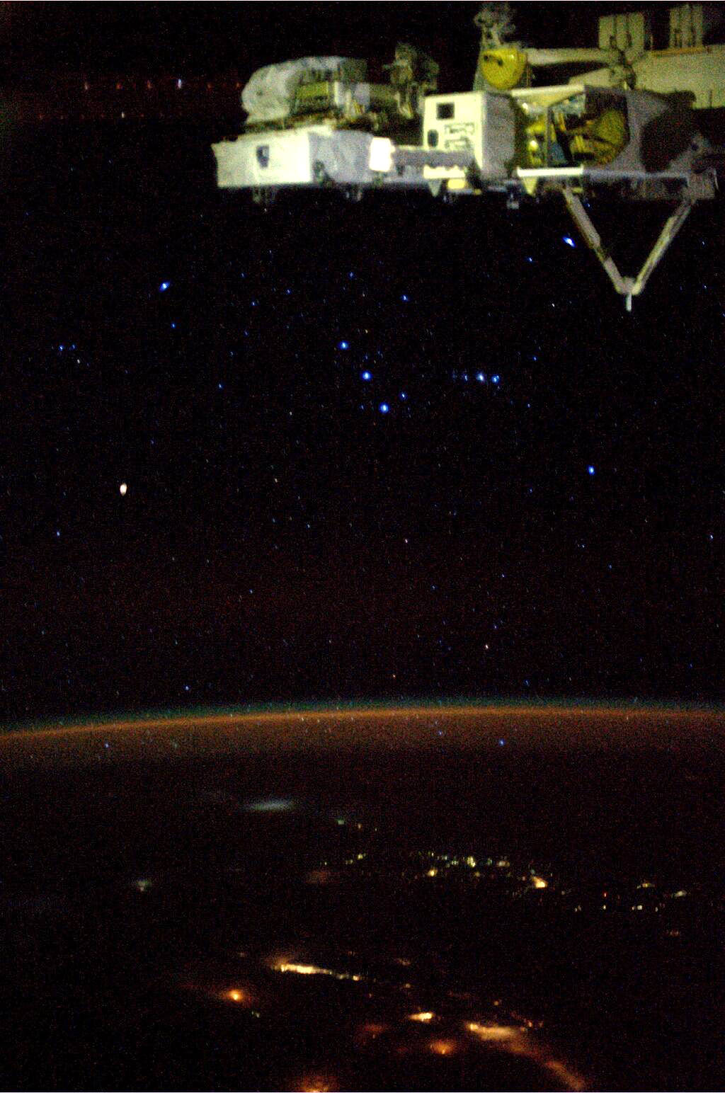
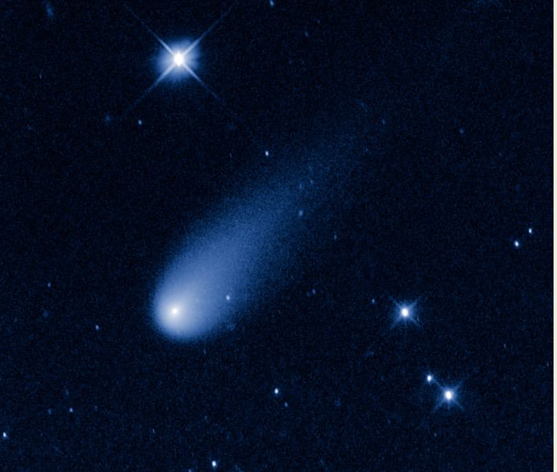
The constellation Orion photographed from orbit by Karen Nyberg (NASA)
The mighty hunter soars above the atmosphere in this photo, taken by NASA astronaut Karen Nyberg currently living and working in space aboard the ISS. One of the most recognizable constellations in night skies all across the Earth, Orion also puts on an impressive display for those well above the Earth!
Appearing here to be lying on his right side, the three stars of Orion’s famous belt — Mintaka, Alnilam, and Alnitak, top to bottom — are center frame, while his sword is nearly horizontal just to the right (the blurry center star of which isn’t a star at all, of course, but rather the enormous star-forming Orion nebula.)
Betelgeuse, as seen by the Hubble Space Telescope.
At Orion’s right shoulder is Betelgeuse, a huge red giant 20 times more massive than our Sun. Its fiery color is obvious in Karen’s photo, mirroring many of the much-closer human-made city lights visible on the ground.
In addition to featuring my favorite constellation, this photo that Karen recently shared on Twitter also serves to prove (to those few who still require evidence of such) that yes, astronauts can see stars from space. Very nicely too, I may add. The only reason they are not visible in all images is purely photographic — cameras exposing for a bright scene, like a daylit Earth (or Moon) won’t be able to capture the relatively much dimmer light of stars in the same shot, making it look like space is empty of them. Even here we can see a bit of noise in the glowing line of Earth’s atmosphere and a little blurring of edges — that’s a result of a high ISO setting to increase camera sensitivity along with a slightly longer shutter speed than your hand can easily keep stable… again, all to better capture the faint streams of photons from distant stars.
We’ve talked about Venus, the hottest planet in the Solar System, but we know things can get pretty hot here on Earth, too. You may be wondering, where on the surface of the Earth has the highest natural temperature been recorded?
The location of this world record has had some controversy, but as of 2013, the hottest spot on record was the Furnace Creek Ranch in California’s Death Valley. On July 10, 1913, weather instruments measured 56.7 degrees Celsius, or 134 degrees Fahrenheit.
The previous record of 56 degrees at El Azizia, Libya was overturned because a systematic study in 2012 discovered there were errors in the measuring methods.
Similar temperatures to Death Valley’s record have been recorded around the World:
55 degrees in Africa,
53.6 in Asia,
50.7 in Australia,
and 49.1 in Argentina.
But these are just measurements from weather stations. It’s likely there are hotter temperatures, but nobody was around to measure. NASA satellites have spotted regions in Iran’s Lut desert which might have reached 70 degrees Celsius during the summers of 2004 and 2005.
So that’d be the hottest spot on the surface, but what about the hottest natural spot anywhere in the entire planet? Now you’ve got to travel straight down 6,371 kilometers to the very center of the Earth. At the inner core, the temperatures rise to about 5,430 degrees C, or 5700 Kelvin. Amazingly, this is about the same temperature as the surface of the Sun.
Some of this high temperature comes from leftover heat from the formation of the planet, 4.54 billion years ago, but the vast majority comes from the decay of radioactive minerals inside the Earth. It was likely hotter in the past, but all the short-period isotopes have already been depleted.
I keep saying the word “natural”, but what about “unnatural”? Wondering about the hottest temperature EVER generated on Earth? Thermonuclear explosions reach temperatures of tens of millions of Kelvin. Fusion experiments have hit 500 million Kelvin. But that’s nothing.
In 2012, physicists working with the Large Hadron Collider were investigating the conditions that might have existed during the earliest moments of the Big Bang.
They generated a quark gluon plasma that had a temperature of 5.5 trillion Kelvin.
Unless aliens can do better, this is not only the hottest temperature ever recorded on Earth, it’s easily the hottest temperature anywhere in the Universe since the Big Bang itself.
According to a new study, meteors may be less dangerous than we thought, thanks to Earth's atmosphere. Credit: David A Aguilar (CfA).
How did life on Earth originally develop from random organic compounds into living, evolving cells? It may have relied on impacts by enormous meteorites and comets — the same sort of catastrophic events that helped bring an end to the dinosaurs’ reign 65 million years ago. In fact, ancient impact craters might be precisely where life was able to develop on an otherwise hostile primordial Earth.
“This is bigger than finding any dinosaur. This is what we’ve all searched for – the Holy Grail of science,” Chatterjee said.
Our planet wasn’t always the life-friendly “blue marble” that we know and love today. At one point early in its history it was anything but hospitable to life as we know it.
“When the Earth formed some 4.5 billion years ago, it was a sterile planet inhospitable to living organisms,” Chatterjee said. “It was a seething cauldron of erupting volcanoes, raining meteors and hot, noxious gasses. One billion years later, it was a placid, watery planet teeming with microbial life – the ancestors to all living things.”
Exactly how did this transition happen? That’s the Big Question in paleontology, and Chatterjee believes he may have found the answer lying within some of the world’s oldest and largest impact craters.
After studying the environments of the oldest known fossil-containing rocks in Greenland, Australia and South Africa, Chatterjee said these could be remnants of ancient craters and may be the very spots where life began in deep, dark and hot environments — similar to what’s found near thermal vents in today’s oceans.
Larger meteorites that created impact basins of about 350 miles in diameter inadvertently became the perfect crucibles, according to Chatterjee. These meteorites also punched through the Earth’s crust, creating volcanically driven geothermal vents. They also brought the basic building blocks of life that could be concentrated and polymerized in the crater basins.
In addition to new organic compounds — and, in the case of comets, considerable amounts of water — impacting bodies may also have brought the necessary lipids needed to help protect RNA and allow it to develop further.
“RNA molecules are very unstable. In vent environments, they would decompose quickly. Some catalysts, such as simple proteins, were necessary for primitive RNA to replicate and metabolize,” Chatterjee said. “Meteorites brought this fatty lipid material to early Earth.”
How organic compounds in crater basins were encapsulated in lipid membranes and became the first cells (Chatterjee)
Based on research in Australia by University of California professor David Deamer, the ingredients for all-important cell membranes were delivered to Earth via meteorites and existed in water-filled craters.
“This fatty lipid material floated on top of the water surface of crater basins but moved to the bottom by convection currents,” suggests Chatterjee. “At some point in this process during the course of millions of years, this fatty membrane could have encapsulated simple RNA and proteins together like a soap bubble. The RNA and protein molecules begin interacting and communicating. Eventually RNA gave way to DNA – a much more stable compound – and with the development of the genetic code, the first cells divided.”
And the rest, as they say, is history. (Well, biology really, and no small amount of chemistry and paleontology… and some astrophysics… well you get the idea.)
Chatterjee recognizes that further experiments will be needed to help support or refute this hypothesis. He will present his findings Oct. 30 during the 125th Anniversary Annual Meeting of the Geological Society of America in Denver, Colorado.
It’s amazing to think that for the majority of human history, we had almost no understanding about the Sun. We didn’t know what it was made of, how it formed, or how it produced energy. We didn’t know how big it was, and we didn’t know how far away it was.
We orbit the Sun at a distance of about 150 million kilometers. This number is actually an average, since we follow an elliptical path. At its closest point, the Earth gets to 147 million km, and at its most distant point, it’s 152 million km.
Distances in the Solar System are so vast that astronomers use this distance as a standard for measurement, and so the average distance from the Earth to the Sun is called an astronomical unit. Instead of saying that Pluto is 5.87 billion kilometers away from the Sun, astronomers say that it’s 39 astronomical units, or AUs.
You might be surprised to know that the distance from the Sun to the Earth was only determined within the last few hundred years. There were just too many variables. If astronomers knew how big it was, they could figure out how far away it was, or vice versa, but both of these numbers were mysteries.
Ancient astronomers, especially the Greeks, tried estimating the distance to the Sun in several different ways: measuring the length of shadows on Earth, or comparing the size of the Moon and its orbit to the Sun. Unfortunately, their estimates were off at least by a factor of 10.
The key to figuring out the distance to the Sun came from observing Venus as it passed directly in front of the Sun. This rare event, known as a Transit of Venus, happens only twice every 108 years. Once devised, the best opportunities for taking this precise measurement came during the Venus transits of 1761 and 1769. Astronomers were dispatched to remote corners of the globe to observe the precise moment when Venus began to move in front of the Sun, and when it had moved completely across the surface.
By comparing these measurements, astronomers could use geometry to calculate exactly how far away the Sun is. Their initial calculations put the distance at 24,000 times the radius of the Earth. Not bad considering our modern measurement of 23,455 times the radius of the Earth.
Modern astronomers can use radar and laser pulses to calculate the distance to objects in the Solar System. For example, they fire an intense beam of radio waves at a distant object, like Mercury, and then calculate how long it takes for the waves to bounce off the planet and return to Earth. Since the speed of light is well known, the return travel time tells you how far away the planet is.
Astronomy has truly helped us find our place in the Universe. It nice to be living in a time when many of these big mysteries have been solved. I don’t know about you, but I can’t wait to see what’s around the corner of the next discovery.
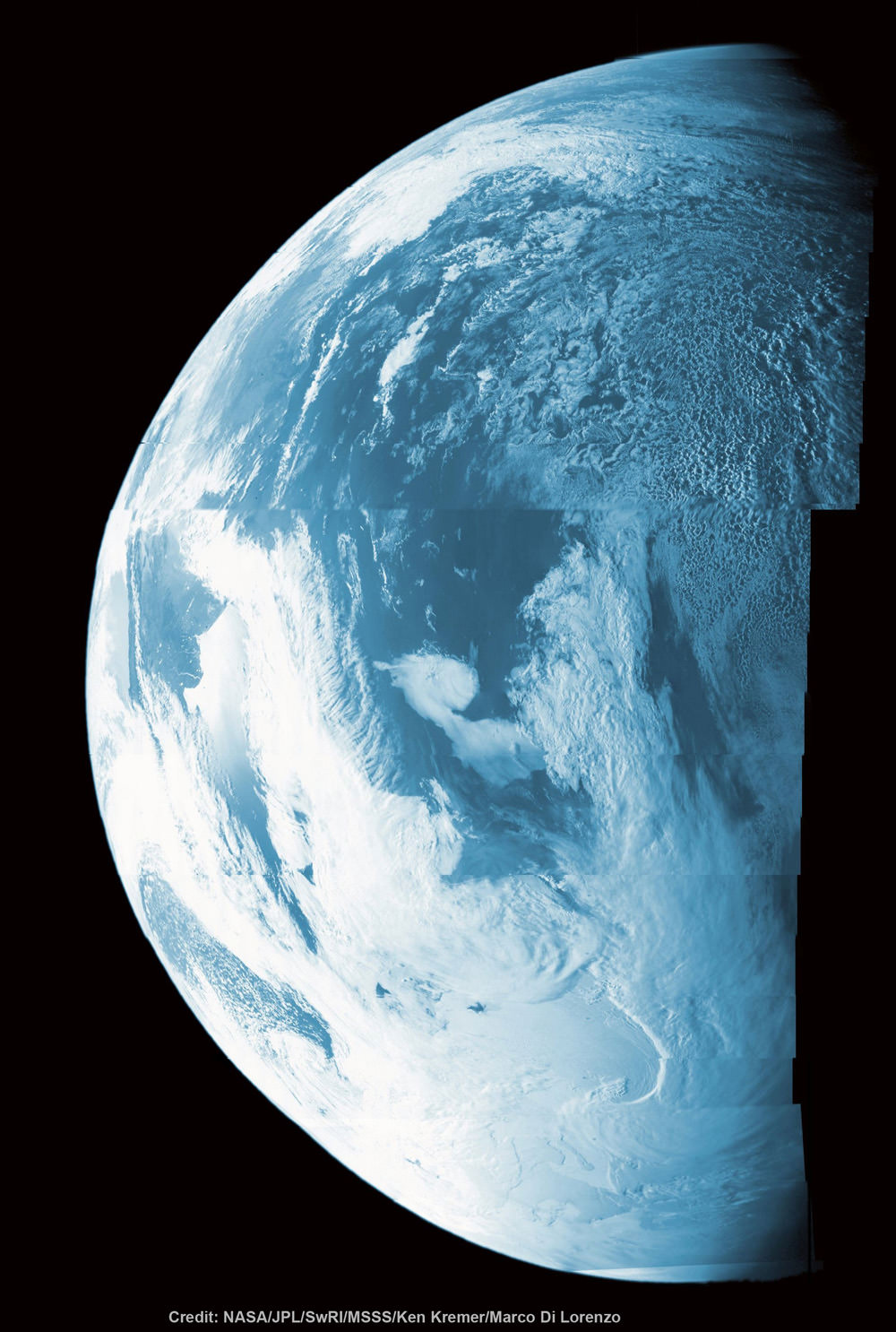
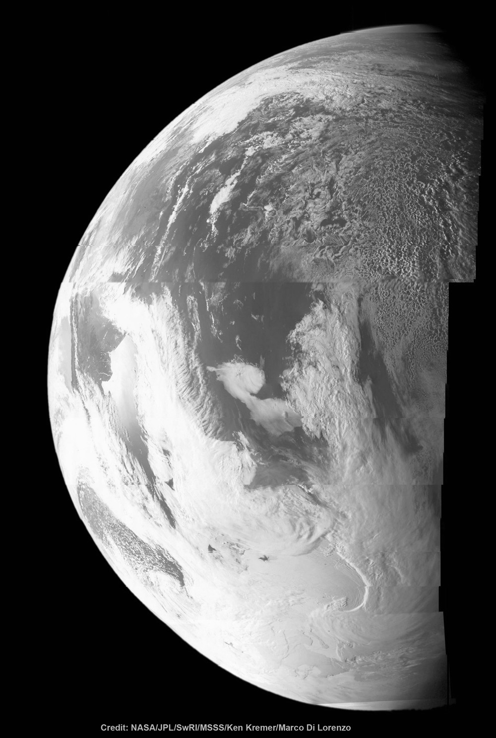
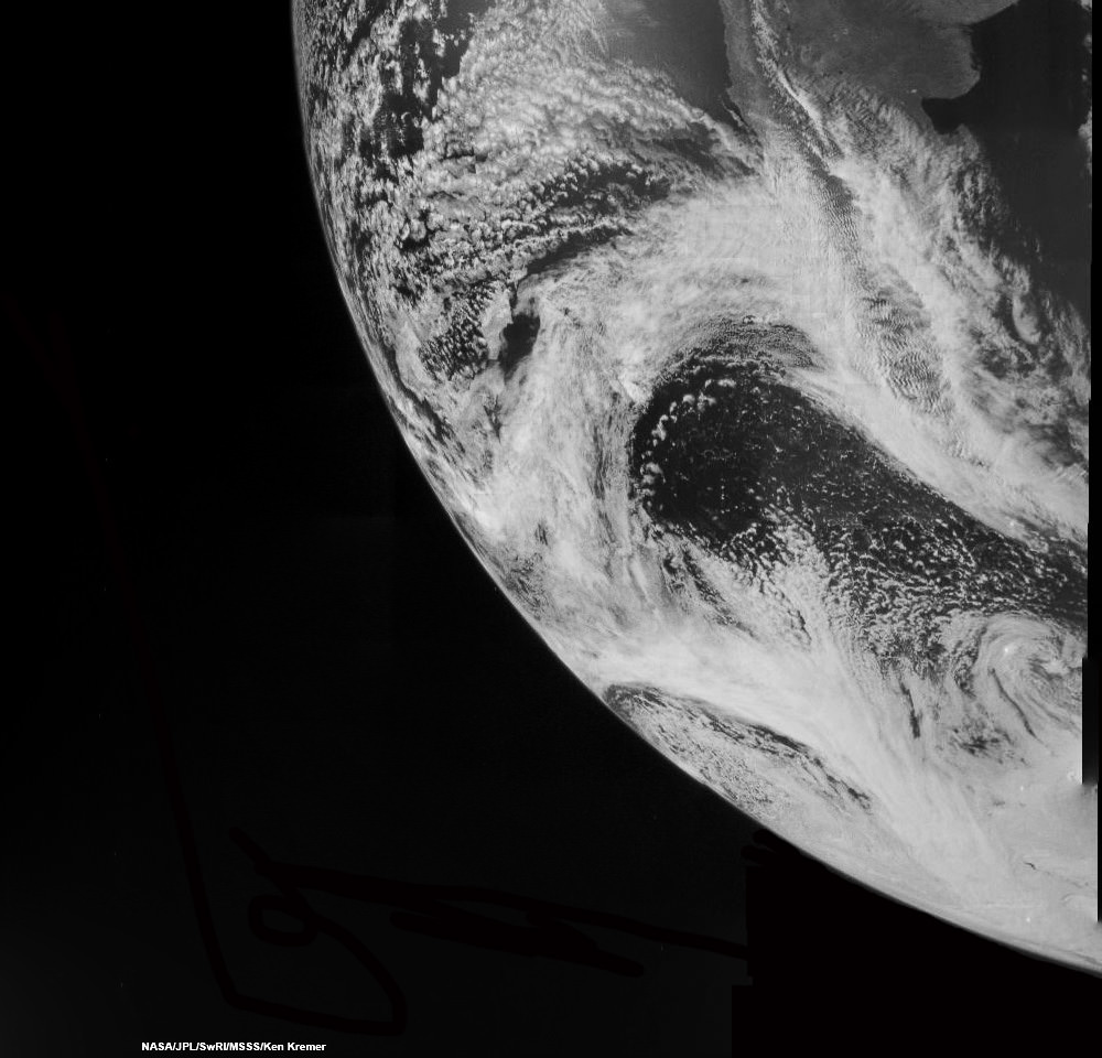
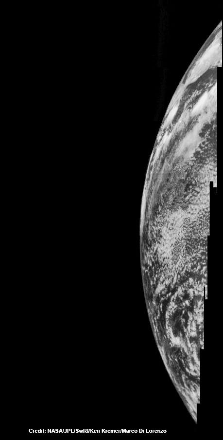
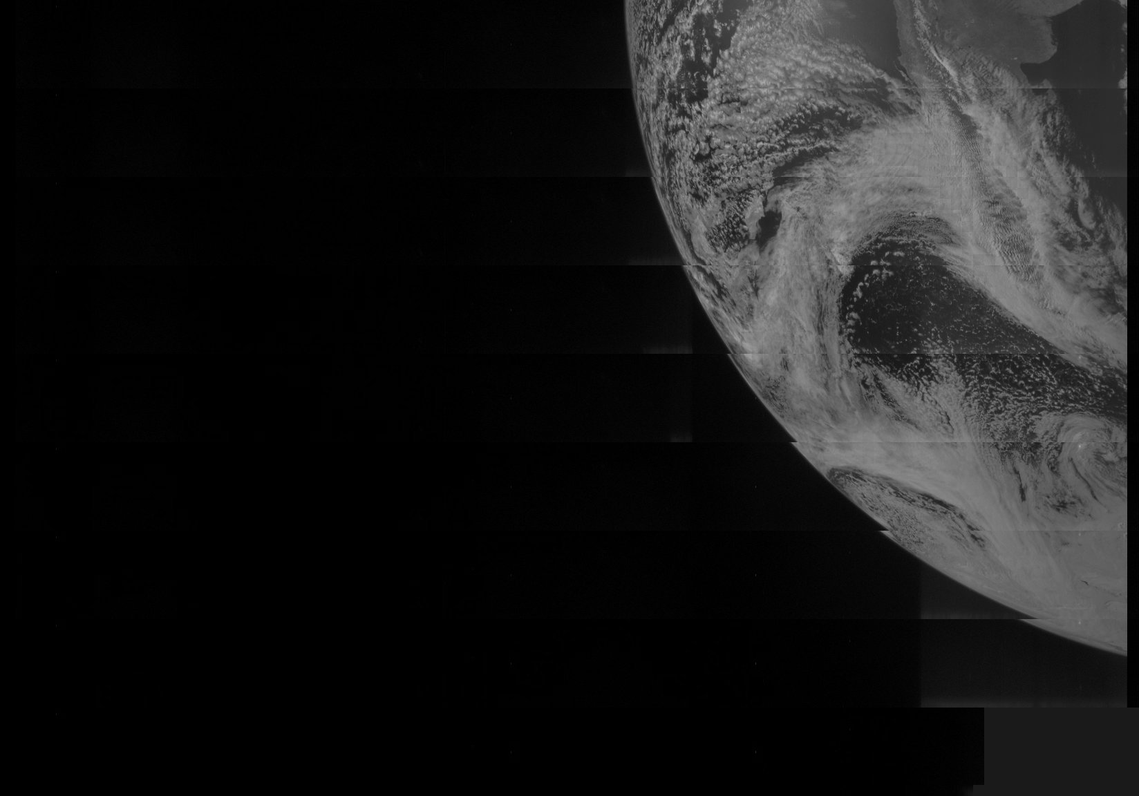
This colorized composite shows more than half of Earth’s disk over the coast of Argentina and the South Atlantic Ocean as the Juno probe slingshotted by on Oct. 9, 2013 for a gravity assisted acceleration to Jupiter. The mosaic was assembled from raw images taken by the Junocam imager. Credit: NASA/JPL/SwRI/MSSS/Ken Kremer/Marco Di Lorenzo
Juno Portrait of Earth
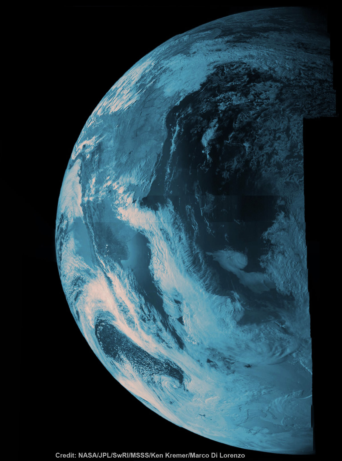
This false color composite shows more than half of Earth’s disk over the coast of Argentina and the South Atlantic Ocean as the Juno probe slingshotted by on Oct. 9, 2013 for a gravity assisted acceleration to Jupiter. The mosaic was assembled from raw images taken by the Junocam imager. Credit: NASA/JPL/SwRI/MSSS/Ken Kremer/Marco Di Lorenzo
See below a gallery of Earth from Juno[/caption]
During a crucial speed boosting slingshot maneuver around Earth on Oct. 9, NASA’s Jupiter-bound Juno probe snapped a dazzling gallery of portraits of our Home Planet over the South American coastline and the Atlantic Ocean. See our mosaics of land, sea and swirling clouds above and below, including several shown in false color.
But an unexpected glitch during the do or die swing-by sent the spacecraft into ‘safe mode’ and delayed the transmission of most of the raw imagery and other science observations while mission controllers worked hastily to analyze the problem and successfully restore Juno to full operation on Oct. 12 – but only temporarily!
Because less than 48 hours later, Juno tripped back into safe mode for a second time. Five days later engineers finally recouped Juno and it’s been smooth sailing ever since, the top scientist told Universe Today.
“Juno is now fully operational and on its way to Jupiter,” Juno principal investigator Scott Bolton told me today. Bolton is from the Southwest Research Institute (SwRI), San Antonio, Texas.
“We are completely out of safe mode!”
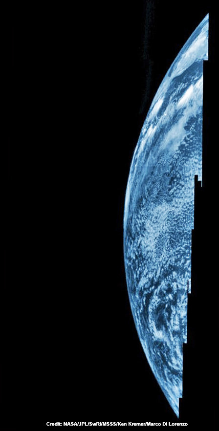
NASA’s Juno probe captured the image data for this composite picture during its Earth flyby on Oct. 9 over Argentina, South America and the southern Atlantic Ocean. Raw imagery was reconstructed and aligned by Ken Kremer and Marco Di Lorenzo, and false-color blue has been added to the view taken by a near-infrared filter that is typically used to detect methane. Credit: NASA/JPL/SwRI/MSSS/Ken Kremer/Marco Di Lorenzo
With the $1.1 Billion Juno probe completely healthy once again and the nail-biting drama past at last, engineers found the time to send the stored photos and research data back to ground station receivers.
“The science team is busy analyzing data from the Earth flyby,” Bolton informed me.
The amateur image processing team of Ken Kremer and Marco Di Lorenzo has stitched together several portraits from raw images captured as Juno sped over Argentina, South America and the South Atlantic Ocean and within 347 miles (560 kilometers) of the surface. We’ve collected the gallery here for all to enjoy.
Several portraits showing the swirling clouds and land masses of the Earth’s globe have already been kindly featured this week by Alan Boyle at NBC News and at the Daily Mail online.
NASA’s Juno probe captured the image data for this composite picture during its Earth flyby on Oct. 9 over Argentina, South America and the southern Atlantic Ocean. Raw imagery was stitched by Ken Kremer and Marco Di Lorenzo in this view taken by a near-infrared filter that is typically used to detect methane. Credit: NASA/JPL/SwRI/MSSS/Ken Kremer/Marco Di Lorenzo
Raw images from the Junocam camera are collected in strips – like a push broom. So they have to be carefully reconstructed and realigned to match up. But it can’t be perfect because the spacecraft is constantly rotating and its speeding past Earth at over 78,000 mph.
So the perspective of Earth’s surface features seen by Junocam is changing during the imaging.
And that’s what is fascinating – to see the sequential view of Earth’s beautiful surface changing as the spacecraft flew over the coast of South America and the South Atlantic towards Africa – from the dayside to the nightside.
This composite shows more than half of Earth’s disk over the coast of Argentina and the South Atlantic Ocean as the Juno probe slingshotted by on Oct. 9, 2013 for a gravity assisted acceleration to Jupiter. The mosaic was assembled from raw images taken by the Junocam imager. Credit: NASA/JPL/SwRI/MSSS/Ken Kremer/Marco Di Lorenzo
It’s rare to get such views since only a few spacecraft have swung by Earth in this manner – for example Galileo and MESSENGER – on their way to distant destinations.
Coincidentally this week, the Cygnus cargo carrier departed the ISS over South America.
Fortunately, the Juno team knew right from the start that the flyby of Earth did accomplish its primary goal of precisely targeting Juno towards Jupiter – to within 2 kilometers of the aim point, despite going into safe mode.
“We are on our way to Jupiter as planned,” Juno Project manager Rick Nybakken, told me in a phone interview soon after the flyby of Earth. Nybakken is from NASA’s Jet Propulsion Lab in Pasadena, CA.
“None of this affected our trajectory or the gravity assist maneuver – which is what the Earth flyby is,” he said.
Juno swoops over Argentina
This reconstructed day side image of Earth is one of the 1st snapshots transmitted back home by NASA’s Jupiter-bound Juno spacecraft during its speed boosting flyby on Oct. 9, 2013. It was taken by the probes Junocam imager and methane filter at 12:06:30 PDT and an exposure time of 3.2 milliseconds. Juno was flying over South America and the southern Atlantic Ocean. The coastline of Argentina is visible at top right. Credit: NASA/JPL/SwRI/MSSS/Ken Kremer
It also accelerated the ships velocity by 16,330 mph (26,280 km/h) – thereby enabling Juno to be captured into polar orbit about Jupiter on July 4, 2016.
Dayside view of a sliver of Earth snapped by Juno during flyby on Oct. 9, 2013. This mosaic is stitched from raw image data captured by methane near-infrared filter on Junocam imager at 11:57:30 PDT. Credit: NASA/JPL/SwRI/MSSS/Ken Kremer/Marco Di Lorenzo
The safe mode did not impact the spacecraft’s trajectory one smidgeon!
It was likely initiated by an incorrect setting for a fault protection trigger for the spacecraft’s battery when Juno was briefly in an eclipse during the flyby.
Nybakken also said that the probe was “power positive and we have full command ability,” while it was in safe mode.
Safe mode is a designated fault protective state that is preprogrammed into spacecraft software in case something goes amiss. It also aims the craft sunwards thereby enabling the solar arrays to keep the vehicle powered.
False-color composite of a sliver of Earth snapped by Juno during flyby on Oct. 9, 2013. This mosaic is stitched from raw image data captured by methane near-infrared filter on Junocam imager at 11:57:30 PDT. Credit: NASA/JPL/SwRI/MSSS/Ken Kremer/Marco Di Lorenzo
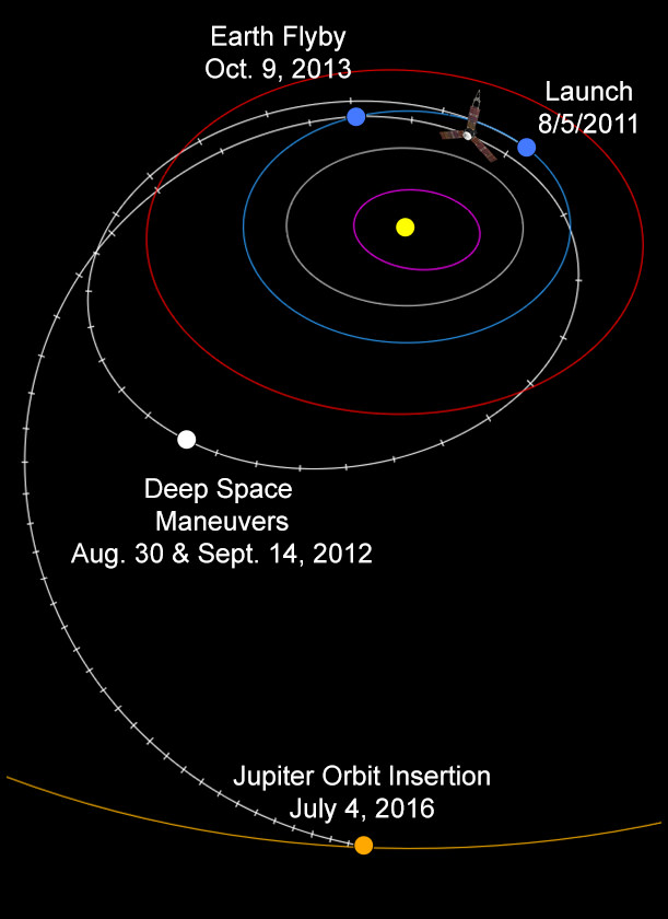
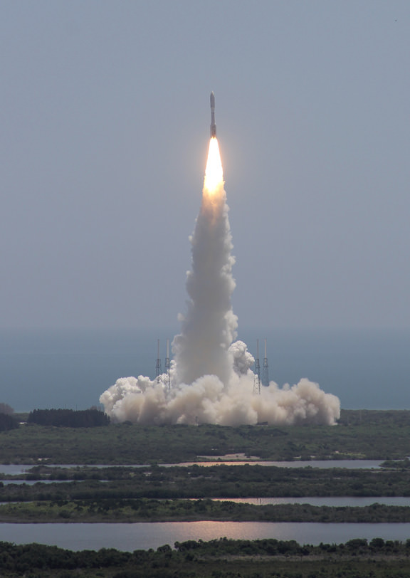
The Earth flyby maneuver was necessary because the initial Atlas V rocket launch on Aug. 5, 2011 from Cape Canaveral Air Force Station, FL was not powerful enough to place Juno on a direct trajectory flight to Jupiter.
As of today, Juno is more than was 6.7 million miles (10.8 million kilometers) from Earth and 739 million miles (7.95 astronomical units) from Jupiter. It has traveled 1.01 billion miles (1.63 billion kilometers, or 10.9 AU) since launch.
With Juno now on course for our solar system’s largest planet, there won’t be no any new planetary images taken until it arrives at the Jovian system in 2016. Juno will then capture the first ever images of Jupiter’s north and south poles.
We have never seen Jupiter’s poles imaged from the prior space missions, and it’s not possible from Earth.
During a year long mission at Jupiter, Juno will use its nine science instruments to probe deep inside the planet to reveal its origin and evolution.
“Jupiter is the Rosetta Stone of our solar system,” says Bolton. “It is by far the oldest planet, contains more material than all the other planets, asteroids and comets combined and carries deep inside it the story of not only the solar system but of us. Juno is going there as our emissary — to interpret what Jupiter has to say.”
Based on what we’ve seen so far, Junocam is sure to provide spectacular views of the gas giants poles and cloud tops.
The International Space Station transiting the Moon as captured by Mike Weasner from Cassiopeia Observatory in Arizona.
This is completely impossible, but fun just the same. How would the Moon look from Earth if it orbited at just 420 km above our planet, which is the same orbital distance as the International Space Station? Here, for the sake of fun, we’re disregarding the Roche Limit and how a body as large as the Moon being that close would completely disrupt so many things on our planet. Plus, as people discussing this on Google+ said, it would be horrible for astrophotography!
This question comes from Andrew Bumford and Steven Stormont.
In a previous episode I’ve talked about how the entire Solar System collapsed down from a cloud of hydrogen and helium left over from the Big Bang. And yet, we stand here on planet Earth, with all its water. So, how did that H20 get to our planet? The hydrogen came from the solar nebula, but where did the oxygen come from?
Here’s the amazing part.
The oxygen came from stars that lived and died before our Sun was even born. When those stars puffed out their final breaths of oxygen, carbon and other “metals”, they seeded new nebulae with the raw material for new worlds. We owe our very existence to the dead stars that came before.
When our Sun dies, it’ll give up some of its heavier elements to the next generation of stars. So, mix hydrogen together with this donated oxygen, and you’ll get H20. It doesn’t take any special process or encouragement, when those two elements come together, water is the result.
But how did it get from being spread across the early Solar System to concentrating here on Earth, and filling up our oceans, lakes and rivers? The exact mechanism is a mystery. Astronomers don’t know for sure, but there are a few theories:
Idea #1: impacts. Take a look at the craters on the Moon and you’ll see that the Solar System was a busy place, long ago. Approximately 3.8 to 4.1 billion years ago was the Late Heavy Bombardment period, when the entire inner Solar System was pummeled by asteroids. The surfaces of the planets and their moons were heated to molten slag because of the non-stop impacts. These impactors could have been comets or asteroids.
Comets are 80% water, and would deliver vast amounts of water to Earth, but they’re also volatile, and would have a difficult time surviving the harsh radiation of the young Sun. Asteroids have a lower ratio of water, but they could protect that water a little better, delivering less with each catastrophic impact.
A false-color, visible-light image of Comet ISON taken with Hubble’s Wide Field Camera 3. Credit: NASA, ESA, and the Hubble Heritage Team (STScI/AURA)
Astronomers have also found many hybrid objects which contain large amounts of both rock and water. It’s hard to classify them either way.
Idea #2 is that large amounts of water just came directly from the solar nebula. As we orbited around the young Sun, it passed through the water-rich material in the nebula and scooped it up. Gravitational interactions between the planets would have transferred material around the Solar System, and it would have added to the Earth’s volume of water over hundreds of millions of years.
Of course, it’s entirely possible that the answer is “all of the above”. Asteroids and comets and the early solar nebula all delivered water to the Earth. Where did the Earth’s water come from? Astronomers don’t know for sure. But I’m sure glad the water is here; life here wouldn’t exist without it.
Juno swoops over Argentina This reconstructed day side image of Earth is one of the 1st snapshots transmitted back home by NASA’s Jupiter-bound Juno spacecraft during its speed boosting flyby on Oct. 9, 2013. It was taken by the probes Junocam imager and methane filter at 12:06:30 PDT and an exposure time of 3.2 milliseconds. Juno was flying over South America and the southern Atlantic Ocean. The coastline of Argentina is visible at top right. Credit: NASA/JPL/SwRI/MSSS/Ken Kremer
Juno swoops over Argentina
This reconstructed day side image of Earth is one of the 1st snapshots transmitted back home by NASA’s Jupiter-bound Juno spacecraft during its speed boosting flyby on Oct. 9, 2013. It was taken by the probes Junocam imager and methane filter at 12:06:30 PDT and an exposure time of 3.2 milliseconds. Juno was flying over South America and the southern Atlantic Ocean. The coastline of Argentina is visible at top right. Credit: NASA/JPL/SwRI/MSSS/Ken Kremer
See another cool Junocam image below[/caption]
Engineers have deftly managed to successfully restore NASA’s Jupiter-bound Juno probe back to full operation following an unexpected glitch that placed the ship into ‘safe mode’ during the speed boosting swing-by of Earth on Wednesday, Oct. 9 – the mission’s top scientist told Universe Today late Friday.
“Juno came out of safe mode today!” Juno principal investigator Scott Bolton happily told me Friday evening. Bolton is from the Southwest Research Institute (SwRI), San Antonio, Texas.
The solar powered Juno spacecraft conducted a crucial slingshot maneuver by Earth on Wednesday that accelerated its velocity by 16,330 mph (26,280 km/h) thereby enabling it to be captured into polar orbit about Jupiter on July 4, 2016.
Dayside view of a sliver of Earth snapped by Juno during flyby on Oct. 9, 2013. This mosaic has been reconstructed from raw image data captured by methane infrared filter on Junocam imager at 11:57:30 PDT. Credit: NASA/JPL/SwRI/MSSS/Ken Kremer/Marco Di Lorenzo
“The safe mode did not impact the spacecraft’s trajectory one smidgeon!”
Juno exited safe mode at 5:12 p.m. ET Friday, according to a statement from the Southwest Research Institute. Safe mode is a designated fault protective state that is preprogrammed into spacecraft software in case something goes amiss.
“The spacecraft is currently operating nominally and all systems are fully functional,” said the SwRI statement.
Although the Earth flyby did accomplish its primary goal of precisely targeting Juno towards Jupiter – within 2 kilometers of the aim point ! – the ship also suffered an unexplained anomaly that placed Juno into ‘safe mode’ at some point during the swoop past Earth.
“After Juno passed the period of Earth flyby closest approach at 12:21 PM PST [3:21 PM EDT] and we established communications 25 minutes later, we were in safe mode,” Juno Project manager Rick Nybakken, told me in a phone interview soon after Wednesday’s flyby of Earth. Nybakken is from NASA’s Jet Propulsion Lab in Pasadena, CA.
Credit: NASA/JPL
Nybakken also said that the probe was “power positive and we have full command ability.”
So the mission operations teams at JPL and prime contractor Lockheed Martin were optimistic about resolving the safe mode issue right from the outset.
“The spacecraft acted as expected during the transition into and while in safe mode,” acording to SwRI.
During the flyby, the science team also planned to observe Earth using most of Juno’s nine science instruments since the slingshot also serves as an important dress rehearsal and key test of the spacecraft’s instruments, systems and flight operations teams.
“The Juno science team is continuing to analyze data acquired by the spacecraft’s science instruments during the flyby. Most data and images were downlinked prior to the safe mode event.”
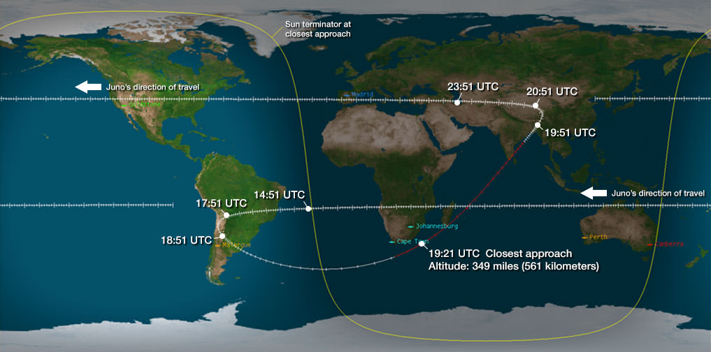
Juno’s closest approach took place over the ocean just off the tip of South Africa at about 561 kilometers (349 miles).
Juno launched atop an Atlas V rocket two years ago from Cape Canaveral Air Force Station, FL, on Aug. 5, 2011 on a journey to discover the genesis of Jupiter hidden deep inside the planet’s interior.
The $1.1 Billion Juno probe is continuing on its 2.8 Billion kilometer (1.7 Billion mile) outbound trek to the Jovian system.
During a one year long science mission – entailing 33 orbits lasting 11 days each – the probe will plunge to within about 3000 miles of the turbulent cloud tops and collect unprecedented new data that will unveil the hidden inner secrets of Jupiter’s origin and evolution.
“Jupiter is the Rosetta Stone of our solar system,” says Bolton. “It is by far the oldest planet, contains more material than all the other planets, asteroids and comets combined and carries deep inside it the story of not only the solar system but of us. Juno is going there as our emissary — to interpret what Jupiter has to say.”
Read more about Juno’s flyby in my articles – at NBC News; here, and Universe Today; here, here and here
Juno swoops over Argentina This reconstructed day side image of Earth is one of the 1st snapshots transmitted back home by NASA’s Jupiter-bound Juno spacecraft during its speed boosting flyby on Oct. 9, 2013. It was taken by the probes Junocam imager and methane filter at 12:06:30 PDT and an exposure time of 3.2 milliseconds. Juno was flying over South America and the southern Atlantic Ocean. The coastline of Argentina is visible at top right. Credit: NASA/JPL/SwRI/MSSS/Ken Kremer
Following the speed boosting slingshot of Earth on Wednesday, Oct. 9, that sent NASA’s Juno orbiter hurtling towards Jupiter, the probe has successfully transmitted back data and the very first flyby images despite unexpectedly going into ‘safe mode’ during the critical maneuver.
“Juno is transmitting telemetry today,” spokesman Guy Webster, of NASA’s Jet Propulsion Lab (JPL), told me in a phone interview late today (Oct. 10), as Juno continues sailing on its 2.8 Billion kilometer (1.7 Billion mile) outbound trek to the Jovian system.
The new images of Earth captured by the Junocam imager serves as tangible proof that Juno is communicating.
“Juno is still in safe mode today (Oct. 10),” Webster told Universe Today.
“Teams at mission control at JPL and Lockheed Martin are actively working to bring Juno out of safe mode. And that could still require a few days,” Webster explained.
Lockheed Martin is the prime contractor for Juno.
The initial raw images of Earth snapped by the craft’s Junocam imager were received by ground stations late today.
See above a day light image mosaic which I reconstructed and realigned based on the original raw image (see below) taken with the camera’s methane filter on Oct. 9 at 12:06:30 PDT (3:06:30 PM EST). Juno was to be flying over South America and the southern Atlantic Ocean.
This day side raw image of Earth is one of the 1st snapshots transmitted back home today by NASA’s Juno spacecraft during its speed boosting flyby on Oct. 9, 2013. It was taken by the probes Junocam imager and methane filter at 12:06:30 PDT and an exposure time of 3.2 milliseconds. Juno was due to be flying over South America and the southern Atlantic Ocean. Credit: NASA/JPL/SwRI/MSSS
Juno performed a crucial swingby of Earth on Wednesday that accelerated the probe by 16330 MPH to enable it to arrive in orbit around Jupiter on July 4, 2016.
However the gravity assist maneuver did not go entirely as planned.
Shortly after Wednesday’s flyby, Juno Project manager Rick Nybakken, of JPL, told me in a phone interview that Juno had entered safe mode but that the probe was “power positive and we have full command ability.”
“After Juno passed the period of Earth flyby closest approach at 12:21 PM PST [3:21 PM EDT] and we established communications 25 minutes later, we were in safe mode,” Nybakken explained.
The safe mode was triggered while Juno was in an eclipse mode, the only eclipse it will experience during its entire mission.
The Earth flyby did accomplish its objective by placing the $1.1 Billion Juno spacecraft exactly on course for Jupiter as intended.
“We are on our way to Jupiter as planned!”
“None of this affected our trajectory or the gravity assist maneuver – which is what the Earth flyby is,” Nybakken stated.
Juno’s closest approach was over South Africa at about 561 kilometers (349 miles).
During the flyby, the science team also planned to observe Earth using most of Juno’s nine science instruments since the slingshot also serves as a key test of the spacecraft systems and the flight operations teams.
Juno also was to capture an unprecedented new movie of the Earth/Moon system.
Many more images were snapped and should be transmitted in coming days that eventually will show a beautiful view of the Earth and Moon from space.
“During the earth flyby we have most of our instruments on and will obtain a unique movie of the Earth Moon system on our approach, Juno principal investigator Scott Bolton told me. Bolton is from the Southwest Research Institute (SwRI), San Antonio, Texas.
“We will also calibrate instuments and measure earth’s magnetosphere, obtain closeup images of the Earth and the Moon in UV [ultraviolet] and IR [infrared],” Bolton explained to Universe Today.
Juno is approaching the Earth from deep space, from the sunlit side.
“Juno will take never-before-seen images of the Earth-moon system, giving us a chance to see what we look like from Mars or Jupiter’” says Bolton.
Here is a description of Junocam from the developer – Malin Space Science Systems
“Like previous MSSS cameras (e.g., Mars Reconnaissance Orbiter’s Mars Color Imager) Junocam is a “pushframe” imager. The detector has multiple filter strips, each with a different bandpass, bonded directly to its photoactive surface. Each strip extends the entire width of the detector, but only a fraction of its height; Junocam’s filter strips are 1600 pixels wide and about 155 rows high. The filter strips are scanned across the target by spacecraft rotation. At the nominal spin rate of 2 RPM, frames are acquired about every 400 milliseconds. Junocam has four filters: three visible (red/green/blue) and a narrowband “methane” filter centered at about 890 nm.”
Juno soars skyward to Jupiter on Aug. 5, 2011 from launch pad 41 at Cape Canaveral Air Force Station at 12:25 p.m. EDT. View from the VAB roof. Credit: Ken Kremer/kenkremer.comJuno launched atop an Atlas V rocket two years ago from Cape Canaveral Air Force Station, FL, on Aug. 5, 2011 on a journey to discover the genesis of Jupiter hidden deep inside the planet’s interior.
During a one year long science mission – entailing 33 orbits lasting 11 days each – the probe will plunge to within about 3000 miles of the turbulent cloud tops and collect unprecedented new data that will unveil the hidden inner secrets of Jupiter’s origin and evolution.
The Earth at night. What will it look like 100 years from now? Image credit: NASA-NOAA
The Earth is warming up.
Ocean temperatures are rising. Arctic sea ice is melting. Atmospheric carbon dioxide levels are growing. The oceans are becoming more acidic. The weather is already more extreme.
With the release of the fifth Assessment Report by the Intergovernmental Panel on Climate Change – a panel of more than 2,500 experts, more commonly known as the IPCC – it’s clear that climate change is very real. But it’s especially clear that we are the cause. If we don’t act now by taking vigorous action to reduce emissions the results will be catastrophic.
Toward the end of this 900-page report, the IPCC looked toward our future, focusing on the climate after the year 2100. Here, Universe Today, explores two extreme scenarios for the Earth by 2100.
1.) Embracing the Challenges of Climate Change
The conclusions reached by climate scientists at the end of the 21st Century were undeniable. We embraced climate change by investing heavily in renewable energies. Both large-scale companies and individuals bought energy drawn from the sunlight, wind, and geothermal heat.
Homes across the world became more sustainable. Their total square feet shrunk, as home owners learned to live with less. It was not uncommon to dress a roof with plants or solar panels. Even the layout of homes changed. They rested partially underground, taking advantage of geothermal heat, and faced South (in the case of the Northern hemisphere) to take advantage of the warm sunlight.
We also embraced geoengineering technologies. We added artificial clouds to our atmosphere, which reflected sunlight, and built towers to collect greenhouse gas emissions. The gases are now trapped deep underground. Our goal was not only to slow the process of climate change, but to stop it, and quite possibly reverse it.
We now eat far less meat than we did in the early 21st Century to cut the emissions generated from livestock farming. Pastures have been replaced with booming forests – helping to absorb CO2. We also eat more locally.
The world followed in China’s footsteps and restricted couples to a certain number of children, reducing our overall population.
We live in small compact cities where we drive hybrid cars and take public transport to work. Carbon offsets must be purchased when taking long trips. Most families vacation in their own backyard – exploring all that nature has to offer in the nearby vicinity.
We viewed climate change as an exciting opportunity to embrace the needs of our environment. We now live much simpler lives and the census shows that our overall intelligence and happiness is much higher than it was a century ago.
2.) The Point of No Return
We simply didn’t want to face the facts. We live in a global economy with a population that has increased significantly over the last century. Most of our energy still comes from fossil fuels. We never invested in renewable energies.
We measure our happiness based on the cars we drive, the number of material possessions we can cram into our large homes, and how often we travel the globe.
The world is, on average, 9 degrees warmer. The entire arctic has melted. Ocean levels have risen by over a meter – flooding coastal communities across the world. Millions have been left homeless.
Our weather is extreme. Hurricanes, tornadoes, fires, floods, draughts, and earthquakes kill hundreds of thousands per year. Climate change has devastated food production and water supplies.
Air quality is much poorer across the world. Due to haze, it is perfectly safe to look at the sun directly. We can only see a third of the stars visible a century ago.
We have triggered various tipping points. The thawing of permafrost released further CO2 and methane. Large areas of the planet are becoming uninhabitable. Our efforts are working toward damage control only. We fear that it may be too late.
Climate change is still in our hands, but we have to act now.
The fifth Assessment Report by the IPCC may be found here. Emphasis in this article may be found in the long term climate change section, as well as descriptions published by the IPCC in 2000.