Names of the Planets

Planets and other objects in our Solar System. Credit: NASA.

[/caption]

You may recognize the names of the planets from your high school literature course or a history class. That is because many of the planets were first discovered by ancient civilizations, and so planets are named after their gods.

The Romans named Mercury after the messenger of the gods because it appears to move so quickly.

Venus was named after the Roman goddess of love because of its shining presence. The planet is the brightest object in the sky beside the Moon and the Sun. A number of other cultures also named Venus after their own gods or goddesses of love and war.

Earth is the only planet not named after a god. The name is based on Germanic and Old English words for “ground.”

Mars was named after the Roman god of war because of its red color, which reminded people of blood. Other civilizations also had names for the planet based on its color. The Egyptians called it “Her Desher,” which means “the red one.”

Jupiter was named after the king of the gods – Zeus by the Greeks and Jupiter by the Romans. Ancient civilizations most likely named this planet after the most powerful god because of its size. Jupiter is the largest and most massive planet in our Solar System.

Saturn was named after the father of the king of gods as well as being the god of agriculture and harvest. In mythology, Saturn had taken the position of king of the gods from his own father, Uranus, and then Jupiter overthrew him. Saturn is the last planet that can be seen from Earth without the aid of a telescope.

Uranus was not discovered until 1781 by Sir William Herschel, so it was not necessarily going to be named after a Roman god. In fact, Herschel named the planet “Georgium Sidus” in honor of George III who was King of England at the time. Others called the planet Herschel in honor of the astronomer who had discovered it. The name Uranus, which is the name of the Roman god who is the father of Jupiter, was suggested by the astronomer Johann Bode. That name was widely accepted in the mid 1800’s, and it fit in with the other planets, which all had names from mythology.

Neptune had been observed by a number of astronomers, but they believed it was a star. Two people, John Couch Adams and Urban Le Verrier, calculated the planet’s location. Johann Galle, the astronomer who discovered the planet using Verrier’s calculations, wanted to name the planet after Verrier. Many astronomers objected though, so it was named after Neptune the Roman god of the sea. The name was very fitting because the planet is a bright sea blue.

Universe Today has a number of articles on the planets including facts about the planets and the planets of the solar system.

If you are looking for more information on the planets take a look at the planets and interesting facts about the planets.

Astronomy Cast has episodes on all of the planets, so start with Mercury.

Continental Drift Theory

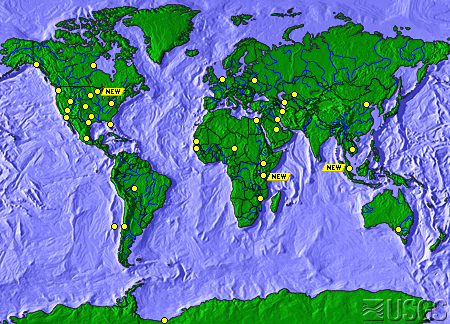
Map showing some of the continents

In elementary school, every teacher had one of those pull-down maps of the world to teach geography. On occasion, I thought the largest land masses, known as continents, reminded me of pieces in a jigsaw puzzle. They just seemed like they should fit together, somehow. Not until I took Earth Science, in 8TH grade, did I discover my earlier idea was correct. My teacher explained about a phenomenon, known as, The Continental Drift Theory. He said that some German had the same idea I did.

The man my teacher mentioned, Alfred Wegener (Vay gen ner), developed The Continental Drift Theory in 1915. He was a meteorolgist and a geologist. His theory basically said that, at one time, there existed one large supercontinent, called, Pangea, pan, meaning all-encompassing, and, gea, meaning the Earth. He went on to suggest that, seismic activity, such as erthquakes, volcanic eruptions, and tsunamis, also called tidal waves, eventually created fissures, or cracks in the Earth. As these fissures became larger, longer, and deeper, 7 pieces of Pangea broke off and, over time, drifted to the places where they are now. These 7 large pieces of land are what we now call, continents. They are: North America; South America; Europe; Asia; Africa; Antarctica; and, Australia. Some people refer to the country as Australia, and the continent as, Oceania. They do this because there are other countries, such as New Zealand, included as a part of that particular continent.

At the time, people thought Wegener was, well, “nuts.” Only in the 1950s did people begin to take his idea seriously. According to the United States Geological Survey (the USGS), thanks to the use of the submarine and the technology developed during World War II, scientists learned a lot about the Ocean Floor. When they found out that it was not as old as the Crust, or Surface, of the Earth, sicentists had to ask themselves, “Why?”

The answers have to do with earthquakes, volcanoes, and magnetism. When the Earth cracks, molten magma, from the middle of the Earth, known as the Mantle, works its way to the surface, where it becomes known as, lava. That lava melts away some of the older layers; then, when the water cools that lava, it forms a new layer of Earth. For that reason, if scientists tried to determine the age of the Earth from samples taken from the Ocean Floor, they would be very wrong.

That same equipment also helped scientists recognize that heavy amounts of basalt, a volcanic rock that contains high amounts of iron, could throw compasses off course. This information provided one more pieces to the puzzle. Now, scientists recognize that the North and South Poles were not always where they currently are.

The Earth changes every day. Although we might not notice it, the continents move all the time. We don’t only revolve, or spin, around the Sun. We also drift across the surface of the planet.

The United States Geological Survey has some excellent information on this topic.

University Today has some other fabulous material about this and related topics, including Earth, Barely Habitable?, by Fraser Cain begin_of_the_skype_highlighting     end_of_the_skype_highlighting, and Interesting Facts About Planet Earth.

You can also read or listen to Episode 51: Earth, of Astronomy Cast, also produced by Universe Today.

Sources:
http://en.wikipedia.org/wiki/Continental_drift
http://www.ucmp.berkeley.edu/history/wegener.html
http://pubs.usgs.gov/gip/dynamic/historical.html

Yellowstone Eruption

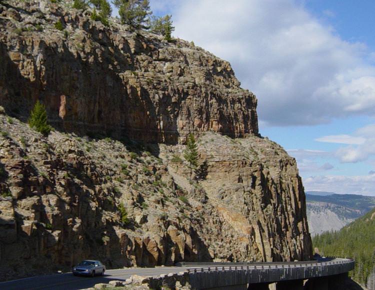
Welded tuff at Yellowstone National Park.

[/caption]
Millions of people visit Yellowstone National Park every year, but how many think about the fact that they’re standing on top of one of the largest volcano calderas on Earth? Within the last 17 million years, there have been more than 100 large eruptions within the Yellowstone caldera, and thousands of smaller lava flows and steam explosions. In fact, the last great Yellowstone eruption happened about 70,000 years ago, and it only seems like a matter of time before it all happens again. Don’t panic, though, geologists monitor Yellowstone carefully, and they don’t think any large eruptions will happen soon.

The Yellowstone calderas measures 55 km wide by 72 km long, and rises to an elevation of 3,142 meters at its tallest point – Mount Sheridan. The constant uprise of the region created a plateau where there used to be a mountain range. These eruptions and uplift helped create the eastern Snake River Plain.

In the last 17 million years, there have been 142 caldera-forming eruptions in Yellowstone. This is an eruption large enough that a significant amount of lava, ash or rock were released – usually as an explosive eruption. Three of these eruptions have been classified as “super eruptions”, where up to 2,500 cubic km of ash and rock exploded out of the volcano. Just for comparison, Mount St. Helens, which erupted in 1980, only released 1 cubic km of material… so 2,500 times that in a single eruption. One of these super eruptions would have devastated most of North America, and cooled the climate of planet Earth for decades. The oldest of these Yellowstone eruptions happened 2.1 million years ago, which created the Huckleberry Ridge Tuff. The next oldest happened 1.3 million years ago, and the most recent super eruption happened about 640,000 years ago.

And since that last super eruption, there have been numerous smaller (but still powerful eruptions) non-explosive eruptions. The most recent lava flow has been estimated to have occurred about 70,000 years ago, and a steam explosion created a 5-km crater 13,800 years ago. The only eruptions that happen at Yellowstone today are the numerous geothermal vents around the caldera. These mix with water to create the famous geysers, like Old Faithful. These geysers indicate that Yellowstone is still a very active region, and more eruptions are likely.

Geologists are continuing to monitor the Yellowstone caldera, including the speed at this the caldera floor is rising up. Like Hawaii, Yellowstone is created by a single volcanic hotspot located under the Earth. The North American Plate is slowly moving over top of the hotspot, creating a long chain of calderas. The current caldera in Wyoming is the current location of the hotspot. Geologists have measured that the caldera floor is rising upwards at almost 7 cm per year. Fortunately, they find no evidence that we’re due for another super Yellowstone eruption. Of course, these things are difficult to predict.

We have written many articles about volcanoes for Universe Today. Here’s an article about about a Yellowstone-like formation on Mars, and an article about how extreme life in Yellowstone might offer hope for the search for life on Mars.

Want more resources on the Earth? Here’s a link to NASA’s Human Spaceflight page, and here’s NASA’s Visible Earth.

We have also recorded an episode of Astronomy Cast about Earth, as part of our tour through the Solar System – Episode 51: Earth.

Source: Wikipedia

Circumference of the Earth

The circumference of the Earth in kilometers is 40,075 km, and the circumference of the Earth in miles is 24,901. In other words, if you could drive your car around the equator of the Earth (yes, even over the oceans), you’d put on an extra 40,075 km on the odometer. It would take you almost 17 days driving at 100 km/hour, 24 hours a day to complete that journey.

If you like, you can calculate the Earth’s circumference yourself. The formula for calculating the circumference of a sphere is 2 x pi x radius. So, the radius of the Earth is 6371 km. Plug that into the formula, and you get 2 x 3.1415 x 6378.1 = 40,074. It would be more accurate if you use more digits for pi.

You might be interested to know that the circumference of the Earth is different depending on how you measure it. If you measure the circumference around the Earth’s equator, you get the 40,075 km figure I mentioned up to. But if you measure it from pole to pole, you get 40,007 km. This is because the Earth isn’t a perfect sphere; it bulges around the equator because it’s rotating on its axis. The Earth is a flattened sphere, and so the distance around the equator is further than the circumference around the poles.

Want some comparison? The circumference of the Moon is 10,921 km, and the circumference of Jupiter is 500,000 km.

Here are a bunch of measurements for you:
Circumference of the Earth in kilometers: 40,075 km
Circumference of the Earth in meters: 40,075,000 meters
Circumference of the Earth in centimeters: 4,007,500,000 centimeters

Circumference of the Earth in miles: 24,901 miles
Circumference of the Earth in feet: 131,477,280 feet
Circumference of the Earth in inches: 1,577,727,360 inches

We have written many articles about Earth for Universe Today. Here are some photos of the Earth and Moon together, and here are the 10 most impressive impact craters on Earth.

Want more resources on the Earth? Here’s a link to NASA’s Human Spaceflight page, and here’s NASA’s Visible Earth.

We have also recorded an episode of Astronomy Cast about Earth, as part of our tour through the Solar System – Episode 51: Earth.

Reference:
NASA Solar System Exploration: Earth Facts and Figures

Albedo of the Earth

The albedo of the Earth is 0.367.

That’s the simple answer, now here’s the more complex one. Astronomers use the term “albedo” to define the amount of light that an object in the Solar System reflects. For example, if a planet was perfectly shiny, it would have an albedo of 1.00; it would reflect 100% of the light that hit it. If a planet was perfectly dark, it would have an albedo of 0, and so it would reflect 0% of the light that struck it.

The object with the highest albedo in the Solar System is Saturn’s moon Enceladus, with an albedo of 99%. On the other hand, asteroids can have albedos as low as 4%. The Earth’s moon has an albedo of about 7%. Can you imagine if we had Enceladus for a moon? Now that would be bright.

The albedo of the Earth is very important because it helps define the temperature of the planet. Fresh snow has an albedo of 90%, while the ocean has a very low albedo; land areas range from 0.1 to 0.4.

NASA’s Terra and Aqua satellites are constantly measuring the albedo of the Earth with their MODIS instruments, to help detect any evidence that the albedo is changing over time.

We have written many articles about the Earth for Universe Today. Here’s an article about how scientists track Earthshine on the Moon. And here’s a more detailed article about the albedo of the Moon.

Want more resources on the Earth? Here’s a link to NASA’s Human Spaceflight page, and here’s NASA’s Visible Earth.

We have also recorded an episode of Astronomy Cast about Earth, as part of our tour through the Solar System – Episode 51: Earth.

What is the Diameter of Earth?

Our beautiful, precious, life-supporting Earth as seen on July 6, 2015 from a distance of one million miles by a NASA scientific camera aboard the Deep Space Climate Observatory spacecraft. Credits: NASA

For those people who have had the privilege of jet-setting or traveling the globe, its pretty obvious that the world is a pretty big place. When you consider how long it took for human beings to settle every corner of it (~85,000 years, give or take a decade) and how long it took us to explored and map it all out, terms like “small world” cease to have any meaning.

But to complicate matters a little, the diameter of Earth – i.e. how big it is from one end to the other – varies depending on where you are measuring from. Since the Earth is not a perfect sphere, it has a different diameter when measured around the equator than it does when measured from the poles. So what is the Earth’s diameter, measured one way and then the other?

Oblate Spheroid:

Thanks to improvements made in the field of astronomy by the 17th and 18th centuries  – as well as geodesy, a branch of mathematics dealing with the measurement of the Earth – scientists have learned that the Earth is not a perfect sphere. In truth, it is what is known as an “oblate spheroid”, which is a sphere that experiences flattening at the poles.

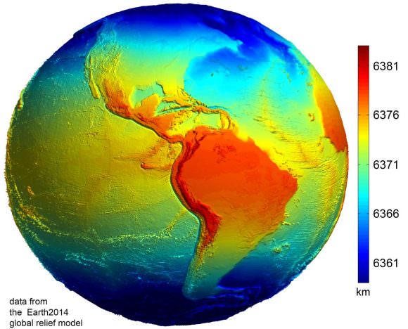
Data from the Earth2014 global relief model, with distances in distance from the geocentre denoted by color. Credit: Geodesy2000

According to the 2004 Working Group of the International Earth Rotation and Reference Systems Service (IERS), Earth experiences a flattening of 0.0033528 at the poles. This flattening is due to Earth’s rotational velocity – a rapid 1,674.4 km/h (1,040.4 mph) – which causes the planet to bulge at the equator.

Equatorial vs Polar Diameter:

Because of this, the diameter of the Earth at the equator is about 43 kilometers (27 mi) larger than the pole-to-pole diameter. As a result, the latest measurements indicate that the Earth has an equatorial diameter of 12,756 km (7926 mi), and a polar diameter of 12713.6 km (7899.86 mi).

In short, objects located along the equator are about 21 km further away from the center of the Earth (geocenter) than objects located at the poles. Naturally, there are some deviations in the local topography where objects located away from the equator are closer or father away from the center of the Earth than others in the same region.

The most notable exceptions are the Mariana Trench – the deepest place on Earth, at 10,911 m (35,797 ft) below local sea level – and Mt. Everest, which is 8,848 meters (29,029 ft) above local sea level. However, these two geological features represent a very minor variation when compared to Earth’s overall shape – 0.17% and 0.14% respectively.

Meanwhile, the highest point on Earth is Mt. Chiborazo. The peak of this mountain reaches an attitude of 6,263.47 meters (20,549.54 ft) above sea level. But because it is located just 1° and 28 minutes south of the equator (at the highest point of the planet’s bulge), it receives a natural boost of about 21 km.

Mean Diameter:

Because of the discrepancy between Earth’s polar and equatorial diameter, astronomers and scientists often employ averages. This is what is known as its “mean diameter”, which in Earth’s case is the sum of its polar and equatorial diameters, which is then divided in half. From this, we get a mean diameter of 12,742 km (7917.5 mi).

The difference in Earth’s diameter has often been important when it comes to planning space launches, the orbits of satellites, and when circumnavigating the globe. Given that it takes less time to pass over the Arctic or Antarctica than it does to swing around the equator, sometimes this is the preferred path.

We have written many interesting articles about the Earth and mountains here at Universe Today. Here’s Planet Earth, The Rotation of the Earth, What is the Highest Point on Earth?, and Mountains: How Are They Formed?

Here’s how the diameter of the Earth was first measured, thousands of years ago. And here’s NASA’s Earth Observatory.

We did an episode of Astronomy Cast just on the Earth. Give it a listen, Episode 51: Earth.

Sources:

Are We Living in a New Geologic Epoch?

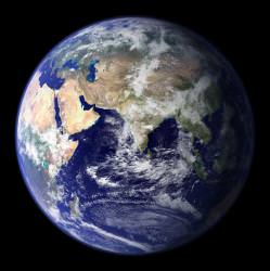
globe_east_540.thumbnail.jpg

Have humans changed our planet Earth so much in the past 200 years that we are now living in a new geological age? A group of geologists believes this is the case. They have formally proposed designating a new geologic epoch, the Anthropocene, which would encompass the past 200 years or so of geologic history. The action is appropriate, they say, because during the past 2 centuries, human activity has caused most of the major changes in Earth’s topography and climate.

Like rings in a tree, each layer in Earth’s geologic record reflects the conditions of the time it was deposited and offers a glimpse into Earth’s past. In this geologic history that is written in the rocks and soil of our planet, researchers have differentiated the layers into classifications of time called eons, eras, periods, epochs, and ages that reflect characteristic conditions. For example, the Carboniferous period, which lasted from 360 million to 300 million years ago, is known for the vast deposits of coal that formed from jungles and swamps. Even some of the longer stretches have been named based on biology, such as the Paleozoic (“old life”) and the Cenozoic (“recent life”).

Earth has been has always been subject to the same kinds of physical forces–wind, waves, sunlight–throughout the planet’s existence. But the life that has arisen on the planet has had a much more varied impact such as the rise of plants that has shaped the planet in dramatic ways. But in the past 200 years, ever since the human population has reached 1 billion, our influences have affected the composition of Earth’s strata, altering the physical and chemical nature of ocean sediments, ice cores and surface deposits. Some of these influences are the use of fossil fuels and the growth of large cities.

British Geologist Jan Zalasiewicz and several colleagues argue that the International Commission on Stratigraphy should officially mark the end of the current epoch. That would be the Holocene (“entirely recent”), which started after the end of the last ice age, about 10,000 years ago. The new epoch would be the Anthropocene.

The evidence the geologists cite include the dramatic increase in lead concentration in the soil and water since about 1800 and the increase of carbon dioxide in the atmosphere. They claim that human processes now vastly outpace the equivalent natural forces. “A reasonable case can be made for the Anthropocene as a valid formal unit,” Zalasiewicz says.

The argument has merit, says American geologist Richard Alley. “In land, water, air, ice, and ecosystems, the human impact is clear, large, and growing,” he says. “A geologist from the far distant future almost surely would draw a new line, and begin using a new name, where and when our impacts show up.”

Original News Source: AAAS ScienceNow