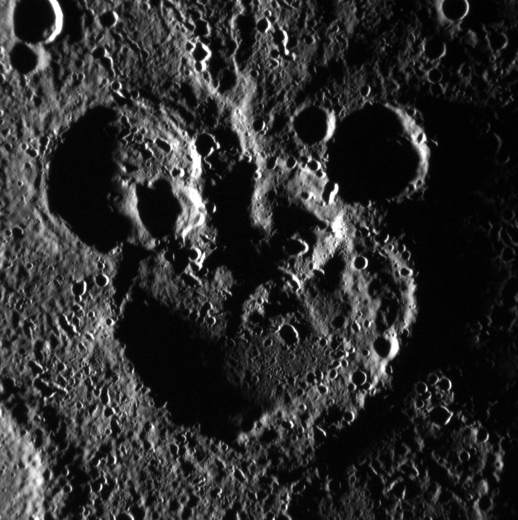
This collection of craters, shaped not unlike the iconic head of a certain cartoon mouse, was imaged by NASA’s MESSENGER spacecraft on June 3, 2012.
All together now: C-R-A, T-E-R… M-O-U-S-Eeeeee…
Acquired as part of MESSENGER’s extended mission to map Mercury’s surface in higher detail, the image above isn’t map-projected; that is, it’s not aligned with north as up. In reality the large crater that makes up Mickey’s “head” is north of the two “ears”.
Still, this is one big mouse head — the large crater in the center has a diameter of approximately 105 km (65 miles)!
Read more about this and see many other images of the first rock from the Sun on the MESSENGER mission site here.
Image credit: NASA/Johns Hopkins University Applied Physics Laboratory/Carnegie Institution of Washington
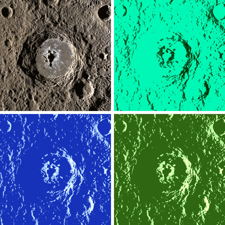
Warhol crater, one of 23 recently named craters on Mercury
[/caption]
As pop art icon Andy Warhol said, “In the future everyone will be famous for fifteen minutes,” and so here’s an image of the crater on Mercury that now bears his name, set up in the style of one of his multicolored silkscreens.
Warhol is one of 23 craters on Mercury to be recently approved for names by the International Astronomical Union (IAU), joining other notable artists, authors and musicians like Gustav Holst, Rene Magritte and Dr. Seuss who now have craters named in their honor on the first rock from the Sun.
95 km (59 miles) in diameter, Warhol crater features a large, elongated central peak, stepped walls and many of the curious erosions known as hollows.
The original image, seen at top left, was acquired by NASA’s MESSENGER spacecraft on October 21, 2011, using its Wide-Angle Camera Mercury Dual Imaging System (MDIS) instrument.
With the new list of 23 named craters, there are now 76 officially (and artistically) titled craters on Mercury since MESSENGER’s first pass of the planet in January 2008.
See the original release by the MESSENGER mission team here.
“I’m bored with that line. I never use it anymore. My new line is “In 15 minutes everybody will be famous.”
– Andy Warhol (1928 – 1987)
Image credit: NASA/Johns Hopkins University Applied Physics Laboratory/Carnegie Institution of Washington
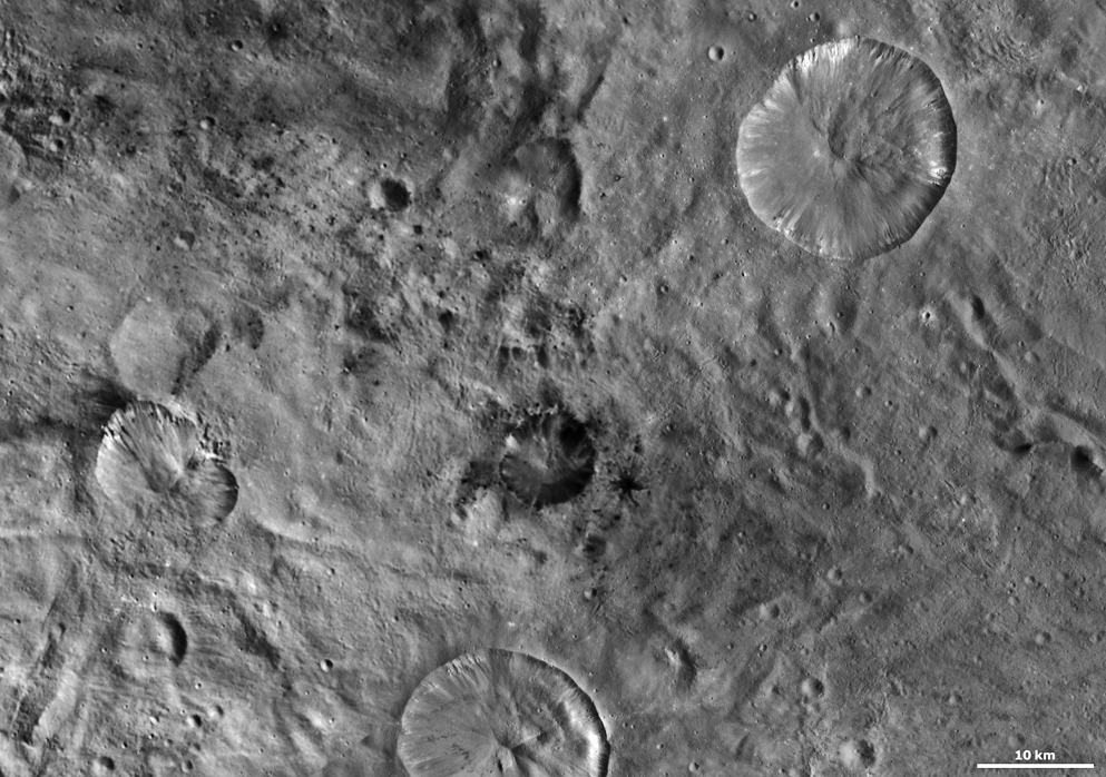
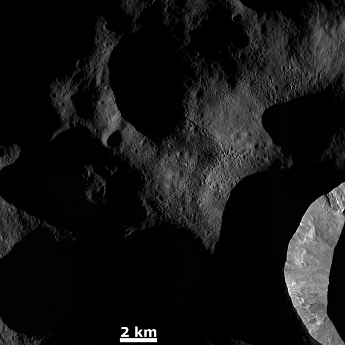
Bright craters, dark craters… craters shaped like butterflies… they’re all represented here in a panorama made from images acquired by NASA’s Dawn spacecraft, currently in orbit around the asteroid Vesta.
I stitched two images together (using a third for gap fill-in) that were originally acquired by Dawn’s framing camera in October 2011 and released last week. Because the angle of sunlight is pretty close to straight-on, there’s not a whole lot of relief in the original images so I bumped that contrast up a bit as well, to help bring out Vesta’s terrain.
The dark crater in the center is Laelia, and it’s surrounded by smaller dark impact craters as well… most notably one that displays dramatic rays of dark material. At top right is the much larger crater Sextilia, which has bright material revealed along its inner rim.
Near the lower left edge, just horizontal from Laelia, is the butterfly-shaped Helena crater. It shows both bright and dark material, the latter of which can be seen slumping into the crater as well as outward from its rim. Helena is approximately 22 kilometers (14 miles) in diameter. (There’s a scale at the lower right showing a 10-km / 6.2-mile-wide span.)
The images were acquired during the HAMO (high-altitude mapping orbit) phase of the mission.
On Thursday, May 10, NASA will host a news conference at 11 a.m. PDT (2 p.m. EDT) to present a new analysis of the giant asteroid Vesta using data from the agency’s Dawn spacecraft. The event will be broadcast live on NASA Television and streamed on the agency’s website. For streaming video, downlink and scheduling information visit: http://www.nasa.gov/ntv.
The event will also be streamed live on Ustream with a moderated chat available at http://www.ustream.com/nasajpl2. Questions may also be asked via Twitter using the hashtag #asknasa.The event will be held at NASA Headquarters in Washington, broadcast live on NASA Television and streamed on the agency’s website. For NASA TV streaming video, downlink and scheduling information, visit: http://www.nasa.gov/ntv.
Image credit: NASA/ JPL-Caltech/ UCLA/ MPS/ DLR/ IDA. Edited by J. Major.
This artist's concept shows NASA's Dawn spacecraft orbiting the giant asteroid Vesta. (NASA/JPL-Caltech)
Vesta's surface textures get highlighted by dawn's light
[/caption]
Sunrise on Vesta highlights the asteroid’s varied surface textures in this image from NASA’s Dawn spacecraft, released on Monday, Feb. 20. The image was taken on Dec. 18 with Dawn’s Framing Camera (FC).
Just as the low angle of early morning sunlight casts long shadows on Earth, sunrise on Vesta has the same effect — although on Vesta it’s not trees and buildings that are being illuminated but rather deep craters and chains of pits!
The steep inner wall of a crater is seen at lower right with several landslides visible, its outer ridge cutting a sharp line.
Chains of pits are visible in the center of the view. These features are the result of ejected material from an impact that occurred outside of the image area.
Other lower-profile, likely older craters remain in shadow.
Many of these features would appear much less dramatic with a high angle of illumination, but they really shine brightest in dawn’s light.
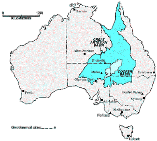
The Cooper Basin hides an impact crater that was recently discovered by geothermal energy researchers. The crater may be the second largest discovered in Australia. Image Credit: Southern Australia Dept. of Transport, Energy and Infrastructure
[/caption]
Geothermal energy researchers from the University of Queensland in Australia have identified what may be the second largest meteorite impact crater in Australia. Dr. Tonguç Uysal of the University of Queensland and Dr. Andrew Glikson of Australian National University identified rock structures that appear to have formed because of the shock of a meteorite impact. Their discovery was made while doing geothermal energy research in the Cooper Basin, which lies on the border between Queensland and South Australia.
The meteorite that caused the impact was likely 8 to 12 km in diameter (5 to 7.5 miles), Dr. Glikson said in an interview. It is also possible that a cluster of smaller meteorites impacted the region, so further testing is needed to pin down the exact nature of the impactor. The impact likely occurred over 300 million years ago, and the shock of the impact altered rock in a zone 80 km (50 miles) in diameter.
Dr. Glikson said, “Dr Uysal is studying the geochemistry and isotopes of granites from the basement below the Cooper Basin and observed potential shock lamella in the quartz grains.” Distinctive features of a shock due to a violent event such as a volcanic eruption, meteorite impact or earthquake are preserved in the rock surrounding such an event. In the case of the Cooper Basin impact, “penetrative intracrystalline planar deformation features” – essentially microscopic lines oriented in the same direction – were discovered in quartz grains. Additionally, the magnetic orientation of some of the rocks is slightly altered, further evidence of an impact event.
The impact structure itself may extend 10,000 square kilometers ( 3,850 square miles) and 524 meters (1,700 feet) deep, though Dr. Glikson said that further studies of the area include, “Studies of the geophysical structure of the basement below the Cooper Basin aimed at defining the impact structure.”
There is significant interest in the Cooper Basin as a source of geothermal energy, and there are several oil and gas companies currently mining the region, which is an important on-shore repository of petroleum. The impact event is likely the reason why this region is such a hotspot for geothermal activity.
“Large impacts result in a hydrothermal cell (boiling of ground water) which effect redistribution and re-concentration of K [potassium], Th [thorium] and U [uranium] upwards in the crust, hence elevated generation of heat from crustal zones enriched in the radiogenic elements,” Dr. Glikson explained.
The recent discovery of this impact crater makes it the second largest in Australia, second only to the Woodleigh impact structure (120 km in diameter), which was produced by an asteroid 6 to 12 km (4 to 8 miles) across, about 360 million years ago.
Dr. Glikson and Dr. Uysal will be presenting their findings at the upcoming Australian Geothermal Energy Conference in Adelaide, which runs from the 16th – 19th of November. They also plan to have their results published in a peer-reviewed journal, Dr. Glikson said. You can read a preliminary abstract of their conference paper here.
Orcus Patera is an enigmatic elliptical depression. Credits: ESA/DLR/FU Berlin (G. Neukum
[/caption]
This is one of the strangest looking craters ever found on Mars, and this platypus-tail-shaped depression, called Orcus Patera, is an enigma. The term ‘patera’ is used for complex or irregularly shaped volcanic craters, but planetary scientists aren’t sure if this landform is volcanic in origin. Orcus Patera lies between the volcanoes of Elysium Mons and Olympus Mons, but its formation remains a mystery. This is the latest image of the object, taken by ESA’s Mars Express.
It could be an impact crater that originally was round, but then subsequently deformed by compressional forces. Or, it could have formed from two craters next to each where the adjoining rims eroded. However, the most likely explanation is that it was made in an oblique impact, when a small body struck the surface at a very shallow angle.
Relief image of Orcus Patera. Credit: ESA/DLR/FU Berlin (G. Neukum)
It is 380 km long by by 140 km wide, and has a rim that rises up to 1,800 meters above the surrounding plains, while the floor of the depression lies 400–600 m below the surroundings. The floor of the depression is unusually smooth.
The image above was created using a Digital Terrain Model (DTM) obtained from the High Resolution Stereo Camera on ESA’s Mars Express spacecraft. Elevation data from the DTM are color-coded: purple indicates the lowest-lying regions, and beige the higher elevations. The scale is in meters.
High-resolution view from LRO of an unusual crater near Moon’s north pole, Rozhdestvensky (110 miles, or 177 kilometers in diameter). Credit: NASA
[/caption]
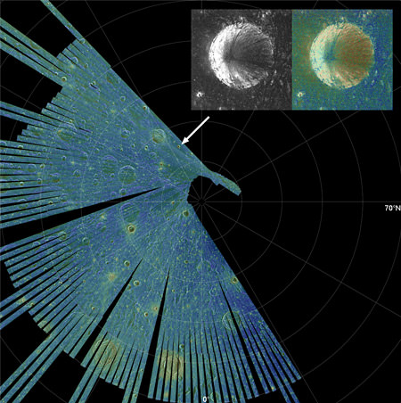
Radar has been used since the 1960s to map the lunar surface, but until recently it has been difficult to get a good look at the Moon’s poles. In 2009, the Mini-SAR radar instrument on the Chandrayaan-1 spacecraft was able to map more than 95% of both poles at 150 meter radar resolution, and now the Mini-RF instrument on the Lunar Reconnaissance Orbiter — which has 10 times the resolution of the Mini-SAR — is about halfway through its first high-resolution mapping campaign of the poles. The two instruments are revealing there are likely massive amounts of water in the permanently shadowed craters at the poles, with over 600 million metric tons at the north pole alone. “If that was turned into rocket fuel, it would be enough to launch the equivalent of one Space Shuttle per day for over 2,000 years,” said Paul Spudis, principal investigator for the Mini-SAR, speaking at the annual Lunar Forum at the Ames Research Center in July.
Both Spudis and Ben Bussey, principal investigator for LRO’s Mini-RF shared images from their respective instruments at the Forum, highlighting polar craters that exhibit unusual radar properties consistent with the presence of ice.
They have found over 40 craters on the Moon’s north pole that exhibit these properties.
Both instruments provide details of the interior of shadowed craters, not able to be seen in visible light. In particular, a measurement called the circular polarization ratio (CPR) shows the characteristics of the radar echoes, which give clues to the nature of the surface materials in dark areas. The instruments send pulses of left-polarized radio waves to measure the surface roughness of the Moon. While smooth surfaces send back a reversed, right-polarized wave, rough areas return left-polarized waves. Ice, which is transparent to radio waves, also sends back left-polarized waves. The instruments measure the ratio of left to right circular polarized power sent back, which is the CPR.
Few places – even in our solar system — have a CPR greater than 1 but such places have thick deposits of ice, such as Martian polar caps, or the icy Galilean satellites. They are also seen in rough, rocky ejecta around fresh, young craters, but there, scientists also observe high CPR outside the crater rim such as in this image, below of the Main L crater on the Moon.
The fresh impact crater Main L (14 km diameter), which shows high CPR inside and outside its rim. The histograms at right show that the high CPR values within (red line) and outside the crater rim (green line) are nearly identical. Credit: NASA
Most of the Moon has low CPR, but dozens of anomalous north pole craters, such as a small 8 km crater within the larger Rozhdestvensky crater, had a high CPR on the inside, with a low CPR on the rims. That suggests some material within the craters, rather than surface roughness, caused the high CPR signal.
“Geologically, we don’t expect rough, fresh surfaces to be present inside a crater rim but absent outside of it,” Spudis said. “This confirms the high CPR in these anomalous craters is not caused by surface roughness, and we interpret this to mean that water ice is present in these craters.” An “anomalous” crater on the floor of Rozhdestvensky, near the north pole of the Moon. The histogram of CPR values clearly shows that interior points (red line) have higher CPR values than those outside the crater rim (green line). Credit: NASA
Additionally, the ice would have to be several meters thick to give this signature. “To see this elevated CPR effect, the ice must have a thickness on the order of tens of wavelengths of the radar used,” he said. “Our radar wavelength is 12.6 cm, therefore we think that the ice must be at least two meters thick and relatively pure.”
Recent Mini-SAR images (top image) from LRO confirm the Chandrayaan-1 data, with even better resolution. The Mini-RF, Bussey said, is equivalent to a combination of the Arecibo Observatory and the Greenbank Radio telescope in looking at the Moon. “Our polar campaign will map from 70 degrees to the poles and so far we are very pleased with the coverage and quality of the data,” Bussey said.
Spudis said they are seeing less anamolous craters on the Moon’s south pole, but both he and Bussey are looking forward to comparing more data between the two radar instruments to learn more about the permanently shadowed craters on the Moon.
Additionally, other instruments on LRO will also provide insights into the makeup of these anomalous craters.
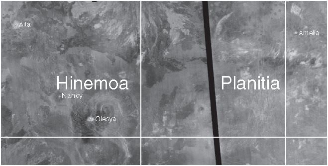
“The name Nancy has been approved for a crater on Venus located at 6.4N, 272.2E.”
I checked with Jennifer Blue, who posts the latest nomenclature planetary news on the USGS site, wondering if the crater was named for anyone in particular or just ‘Nancys’ in general. She told me that small craters (less than 20 km in diameter) on Venus are named with common female first names, while larger craters (over 20 km) are named for deceased women who have made outstanding or fundamental contributions to their field.
This crater is pretty small, and I’m not dead yet, fortunately, so it is not named for me.
“The crater named Nancy is not named for anyone in particular,” Jennifer wrote me. “But you could pretend that it was named for you!”
I think that’s what I’ll do.
UPDATE (8/08/12): I just got a note from Lizzy Tandberg Hall, who said that she named this crater after her mother, Nancy Clay Tandberg while mapping the Devana Chasma Quadrangle.
Here’s a link to a very interesting page, USGS’s “Gazetteer of Planetary Nomenclature” which gives the parameters for naming features on the planetary bodies in our solar system.


")
, which shows high CPR inside and outside its rim. The histograms at right show that the high CPR values within (red line) and outside the crater rim (green line) are nearly identical. Credit: NASA")
 have higher CPR values than those outside the crater rim (green line). Credit: NASA")