Were Lunar Volcanoes Active When Dinosaurs Roamed the Earth?

The feature called Maskelyne is one of many newly discovered young volcanic deposits on the moon. Called irregular mare patches, these areas are thought to be remnants of small lava eruptions that occurred recently in the moon's past. To view this image correctly, the large, dark, circular feature right of center is pancake-like dome that rises ABOVE the surrounding lighter-toned terrain. Lower domes, many pitted with small craters, are seen from left to right across the photo. Credit: NASA/GSFC/Arizona State University

The Moon’s a very dusty museum where the exhibits haven’t changed much over the last 4 billion years. Or so we thought. NASA’s Lunar Reconnaissance Orbiter (LRO) has provided researchers strong evidence the Moon’s volcanic activity slowed gradually instead of stopping abruptly a billion years ago.

Some volcanic deposits are estimated to be 100 million years old, meaning the moon was spouting lava when dinosaurs of the Cretaceous era were busy swatting giant dragonflies. There are even hints of 50-million-year-old volcanism, practically yesterday by lunar standards.

Ina Caldera sits atop a low, broad volcanic dome or shield volcano, where lavas once oozed from the moon’s crust. The darker patches in the photo are blobs of older lunar crust. As in the photo of Maskelyne, they form a series of low mounds higher than the younger, jumbled terrain around them. Credit: NASA

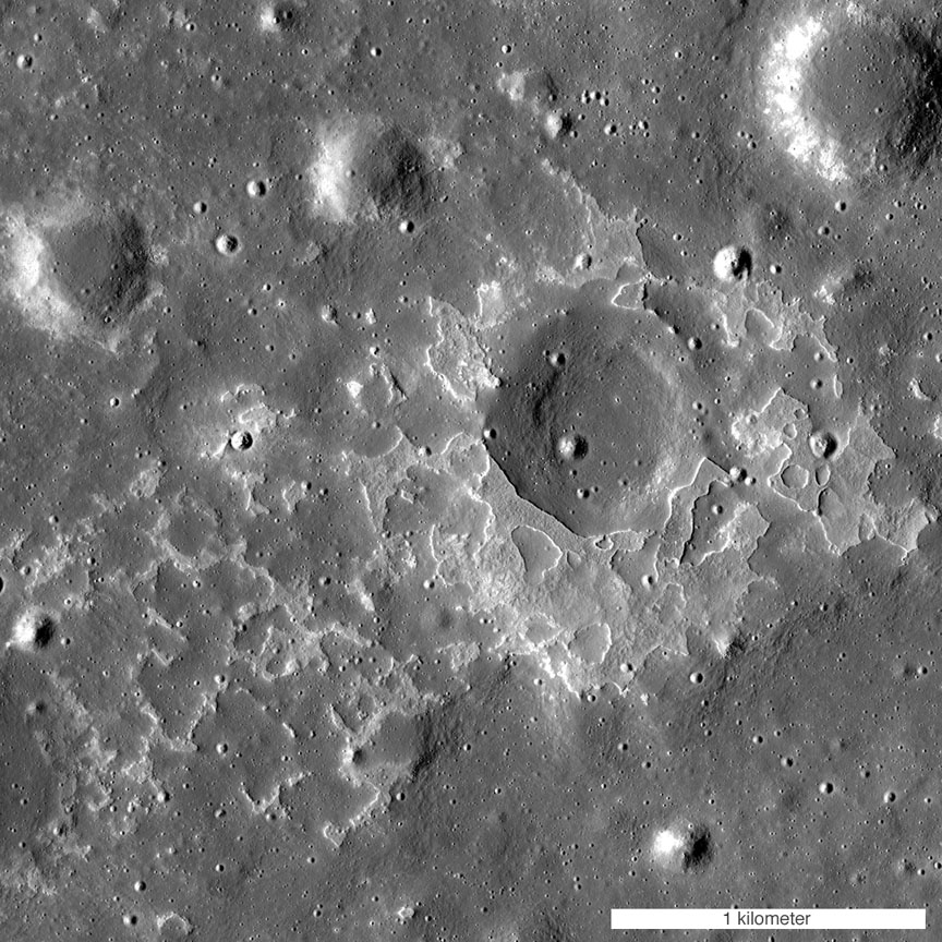
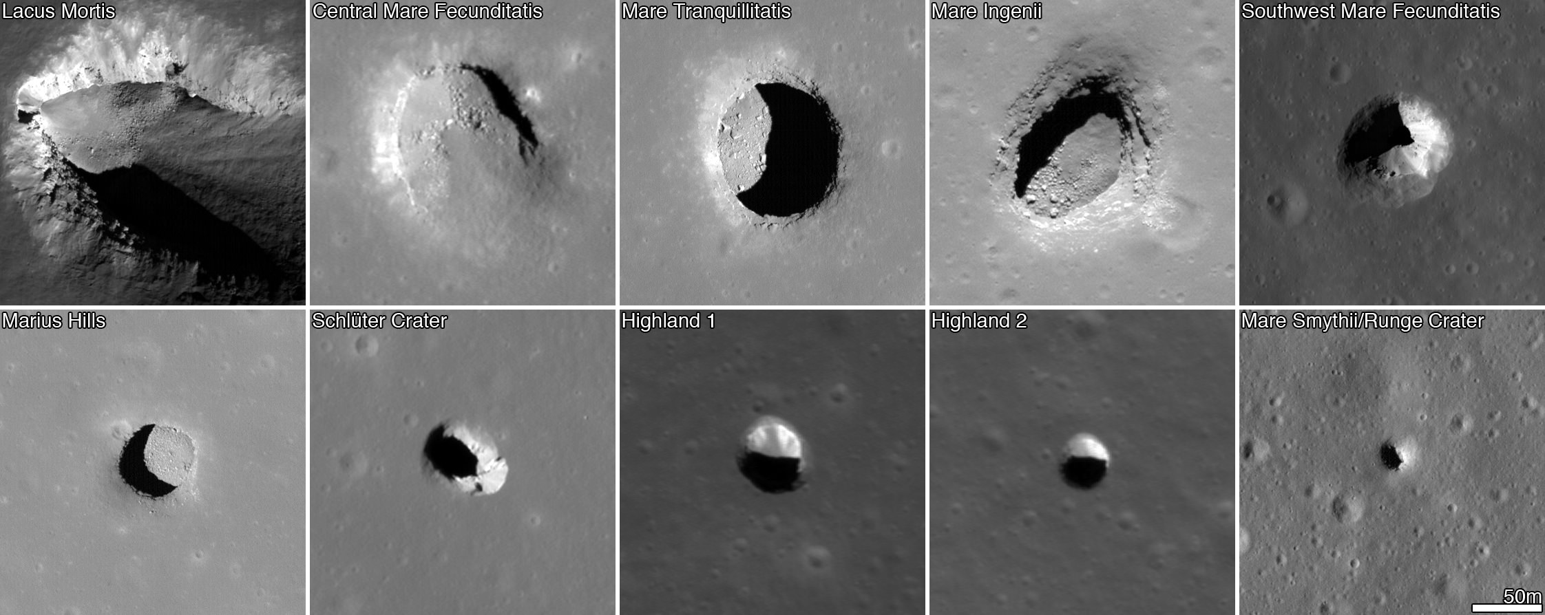
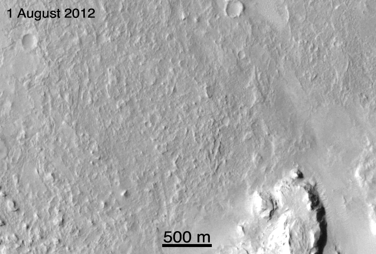
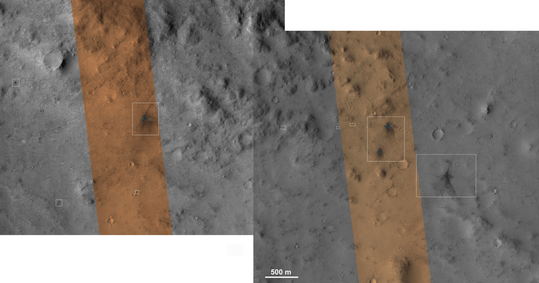
The deposits are scattered across the Moon’s dark volcanic plains (lunar “seas”) and are characterized by a mixture of smooth, rounded, shallow mounds next to patches of rough, blocky terrain. Because of this combination of textures, the researchers refer to these unusual areas as “irregular mare patches.”

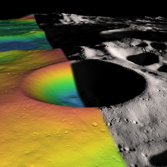
Measuring less than one-third mile (1/2 km) across, almost all are too small to see from Earth with the exception of Ina Caldera, a 2-mile-long D-shaped patch where blobs of older, crater-pitted lunar crust (darker blobs) rise some 250 feet above the younger, rubbly surface like melted cheese on pizza.

Lavas on the moon were thin and runny like this flow photographed in Kilauea, Hawaii. Credit: USGS

Ina was thought to be a one-of-a-kind until researchers from Arizona State University in Tempe and Westfälische Wilhelms-Universität Münster in Germany spotted 70 more patches in close-up photos taken by the LRO. The large number and the fact that the patches are scattered all over the nearside of the Moon means that volcanic activity was not only recent but widespread.

Astronomers estimate ages for features on the moon by counting crater numbers and sizes (the fewer seen, the younger the surface) and the steepness of the slopes running from the tops of the smoother domes to the rough terrain below (the steeper, the younger).

“Based on a technique that links such crater measurements to the ages of Apollo and Luna samples, three of the irregular mare patches are thought to be less than 100 million years old, and perhaps less than 50 million years old in the case of Ina,” according to the NASA press release.

Artist concept illustration of the internal structure of the moon. Credit: NOAJ

The young mare patches stand in stark contrast to the ancient volcanic terrain surrounding them that dates from 3.5 to 1 billion years ago.

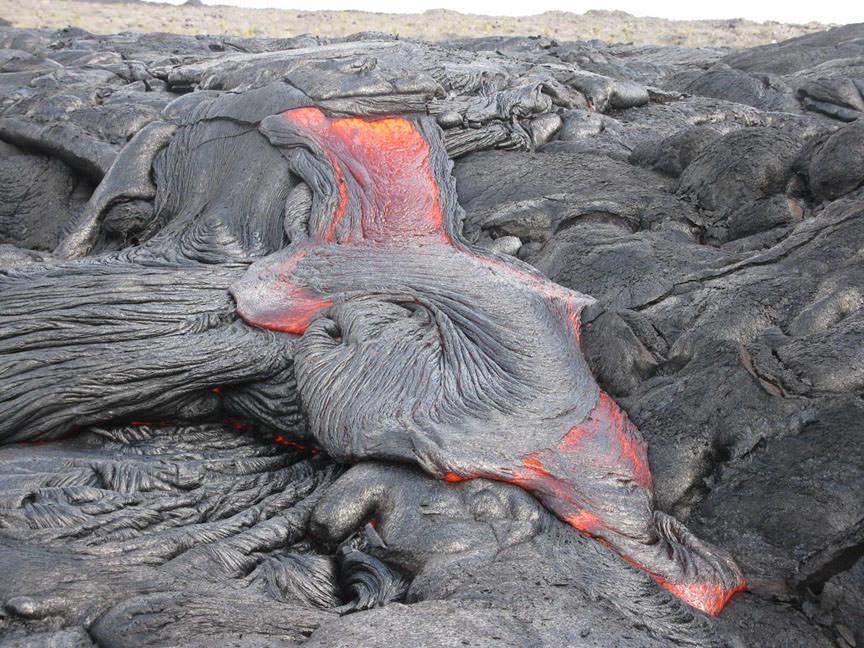
For lava to flow you need a hot mantle, the deep layer of rock beneath the crust that extends to the Moon’s metal core. And a hot mantle means a core that’s still cranking out a lot of heat.

Scientists thought the Moon had cooled off a billion or more years ago, making recent flows all but impossible. Apparently the moon’s interior remained piping hot far longer than anyone had supposed.

“The existence and age of the irregular mare patches tell us that the lunar mantle had to remain hot enough to provide magma for the small-volume eruptions that created these unusual young features,” said Sarah Braden, a recent Arizona State University graduate and the lead author of the study.

It takes two to tango. The moon’s gravity raises a pair of watery bulges in the Earth’s oceans creating the tides, while Earth's gravity stretches and compresses the moon to warm its interior. Illustration: Bob King
It takes two to tango. The moon’s gravity raises a pair of watery bulges in the Earth’s oceans creating the tides, while Earth’s gravity stretches and compresses the moon to warm its interior. Illustration: Bob King

One way to keep the Moon warm is through tidal interaction with the Earth. A recent study points out that strains caused by Earth’s gravitational tug on the Moon (nearside vs. farside) heats up its interior. Could this be the source of the relatively recent lava flows?

So the pendulum swings. Prior to 1950 it was thought that lunar craters and landforms were all produced by volcanic activity. But the size and global distribution of craters – and the volcanoes required to produce them – would be impossible on a small body like the Moon. In the 1950s and beyond, astronomers came to realize through the study of nuclear bomb tests and high-velocity impact experiments that explosive impacts from asteroids large and small were responsible for the Moon’s craters.

This latest revelation gives us a more nuanced view of how volcanism may continue to play a role in the formation of lunar features.

Getting to Know Comet 67P/Churyumov-Gerasimenko

Comet 67P/Churyumov-Gerasimenko at 621 miles (1,000 km) on August 1. Wow! Look at that richly-textured surface. This photo has higher resolution than previous images because it was taken with Rosetta's narrow angle camera. The black spot is an artifact. Credit: ESA/Rosetta/MPS for OSIRIS Team MPS/UPD/LAM/IAA/SSO/INTA/UPM/DASP/IDA

We’re finally getting to know the icy nucleus behind comet 67P/Churyumov-Gerasimenko. For all the wonder that comets evoke, we on Earth never see directly what whips up the coma and tail. Even professional telescopes can’t burrow through the dust and vapor cloaking the nucleus to distinguish the clear outline of a comet’s heart. The only way to see one is to fly a camera there.

Asteroids we've seen up close show cratered surfaces similar to yet different from much of the cratering on comets. Credit:
Asteroids we’ve seen up close show cratered surfaces similar to yet different from much of the cratering so far seen on comets. Not to scale. Credit: NASA except for Steins (ESA)

Rosetta took 10 years to reach 67P/C-G, a craggy, boot-shaped body that resembles an asteroid in appearance but with key differences. Asteroids shown in close up photos often display typical bowl-shaped impact craters. From the photos to date, 67P/C-G’s ‘craters’ look shallow and flat in comparison. Were they impacts smoothed by ice flows over time? Did some of the dust and vapor spewed by the comet settle back on the surface to partially bury and soften the landscape?

Comet 81P/Wild 2 photographed during the Stardust mission in 2004. Wild 2 measures 1.03 x 1.24 x 1.71 miles and goes around the sun once every 6.4 years. Its surfaced is riddled with flat-bottomed craters, some of which may also be gas vents from vaporized ice. Credit: NASA
Comet 81P/Wild 2 photographed during the Stardust mission in 2004. Wild 2 measures 1.03 x 1.24 x 1.71 miles and goes around the sun once every 6.4 years. Its surfaced is riddled with flat-bottomed depressions some of which may also vent gas from vaporizing ice. Click for more 81P/Wild 2 photos. Credit: NASA

While 67P is doubtless its own comet, it does share certain similarities with Comet 81P/Wild including at least a few crater-like depressions seen during NASA’s Stardust mission. In January 2004, the spacecraft gathered photos, measurements and dust samples during its brief flyby of the nucleus. Photos reveal pinnacles, flat-bottomed depressions and bright plumes or jets of vaporizing ice.

Some of the comets we've seen close up through the eyes of visiting spacecraft. Credit: NASA
Some of the comets we’ve seen close up through the eyes of visiting spacecraft. Credit: NASA

In a 2004 paper by Donald Brownlee and team, the group experimentally reproduced the flat-floored craters by firing projectiles into resin-coated sand baked a bit to make it cohere. Their results suggest the craters formed from impacts in loosely compacted material under the low-gravity conditions typical of small objects like comets. To quote the paper: “Most disrupted material stayed inside the cavity and formed a flat-floored deposit and steep cliffs formed the rim.” Icy materials mixed with dust may have also played a role in their appearance and other crater-like depressions called pit-halos.

Latest image of the comet taken by Rosetta's navigation camera on August 2, 2014. Credit: ESA/Rosetta/Navcam
Latest image of the comet taken by Rosetta’s navigation camera from a distance of only 311 miles (500 km) on August 2, 2014. The comet’s larger size in the field means fewer artifacts. Credit: ESA/Rosetta/Navcam

Speculation isn’t science, so I’ll stop here. So much more data will be streaming in soon, we’ll have our hands full. On Wednesday, August 6th, Rosetta will enter orbit around the nucleus and begin detailed studies that will continue through December 2015. Studying the new pictures now arriving daily, I’m struck by the dual nature of comets. We see an ancient landscape and yet one that looks strangely contemporary as the sun vaporizes ice, reworking the terrain like a child molding clay.

Comet 67P/Churyumov-Gerasimenko is well-placed in the mid-summer sky in Sagittarius but impossibly faint to see visually. Dave Herald's photo taken on August 21, 2014 shows only a tiny fuzz of magnitude +21. Credits: Background: Stellarium; David Herald
Comet 67P/Churyumov-Gerasimenko is well-placed in the mid-summer sky in Sagittarius but impossibly faint visually. Dave Herald’s photo taken on August 21, 2014 shows only a tiny fuzz of magnitude +21. Credits: Dave Herald;  Stellarium

How Humanity’s Next Moon Explorers Could Live In Lunar ‘Pits’

Images from the Lunar Reconaissance Orbiter showing pits on the lunar surface. The images are each 222 meters (728 feet) wide. Credit: NASA/GSFC/Arizona State University

Just look at that new video from NASA showing the first moon landing site in three dimensions. It’s tempting to touch on the surface nearby the Eagle lander there in the center and do some prospecting.

You’ll notice a lot of craters in that video, which is based on Lunar Reconnaissance Orbiter data. Across the moon’s surface, a separate study saw the spacecraft investigate 200 extremely steep-walled craters, known as “pits”.

These would be fascinating places to send astronauts for scientific study. Not only that, they’re actually one of the safest spots possible on the moon, according to a new study.

“Pits would be useful in a support role for human activity on the lunar surface,” stated lead researcher Robert Wagner of Arizona State University.

“A habitat placed in a pit — ideally several dozen meters back under an overhang — would provide a very safe location for astronauts: no radiation, no micrometeorites, possibly very little dust, and no wild day-night temperature swings.”

And if you look at the picture below, you can see at least one of those pits is in the Sea of Tranquility — the approximate landing area where Apollo 11 touched down 45 years ago this week. The pits were found mainly using a computer algorithm that scanned LRO photos, although a few of the craters were previously identified with the Japanese Kaguya spacecraft.

Large craters or lunar “seas” (ancient, solidified lava flows) are the locations where most of these pits are found. How they were formed is being investigated, but there are some hypotheses. Perhaps a meteorite impact caused a collapse, or perhaps molten rock flows under the surface gradually lost their lava, leaving voids.

Lunar Reconnaissance Orbiter
Lunar Reconnaissance Orbiter. Image Credit: NASA

To learn more, the researchers say more LRO images would be great (only 40% of the surface imaged had the appropriate lighting conditions for this study) and in the future, we’d need to get much closer-up than pictures taken from orbit.

“The ideal follow-up, of course, would be to drop probes into one or two of these pits, and get a really good look at what’s down there,” added Wagner.

“Pits, by their nature, cannot be explored very well from orbit — the lower walls and any floor-level caves simply cannot be seen from a good angle. Even a few pictures from ground-level would answer a lot of the outstanding questions about the nature of the voids that the pits collapsed into. We’re currently in the very early design phases of a mission concept to do exactly this, exploring one of the largest mare pits.”

You can read more about the research in the journal Icarus.

Source: NASA

Like Yoda This Moon Shadow Looks. Yes, hmmm?

An oblique view from the Lunar Reconnaissance Orbiter of Icarus Crater on the Moon. The shadow created by the unusual central peak in the crater is reminiscent of a certain Star Wars character. Icarus is approximately 94 km in diameter. Credit: NASA/GSFC/Arizona State University.

Scientists from the Lunar Reconnaissance Orbiter say that Icarus Crater is one of a kind on the Moon because its central peak rises higher than about half its rim. Most central peaks rise only about halfway to the crater rim. But at just the ring angle and lighting conditions, the shadow this central peak creates on the rolling and jagged crater rim looks like the Star Wars Character Yoda. Interestingly, this crater is located on what some people erroneously call the “Dark Side” of the Moon – what is actually the lunar farside.

Yoda meditates about moons. Via Blastr.com

Below you can see a closeup of the central peak of Icarus crater rising out of the shadows to greet a new lunar day.

The central peak of Icarus Crater on the Moon’s farside, as seen by LROC. Image width is approximately 10 km, north is to the right. Credit: NASA/GSFC/Arizona State University.

Icarus is located just west of Korolev crater on the lunar farside. The light-colored plains surrounding the craters were deposited during the formation of the Orientale basin, which is located over 1500 km away.

Image from LRO’s Wide Angle Camera of Icarus crater and vicinity. Image width is approximately 365 km. Credit: NASA/GSFC/Arizona State University.

Find out more about these images from LRO and see larger versions at the LROC website.

Moon’s Blotchy Near Side Has Bigger Craters Than Expected

The thickness of the moon's crust as calculated by NASA's GRAIL mission. The near side is on the left-hand side of the picture, and the far side on the right. Credit: NASA/JPL-Caltech/S. Miljkovic

The familiar blotches that make up “the man in the moon”, from the vantage point of Earth, happened because the moon’s crust is thinner on the near side than the far side to our planet, new research reveals.

The twin GRAIL spacecraft provided the most accurate sizes yet of lunar impact craters on the moon, providing more insight into what happened when Earth’s closest large neighbor was hammered with meteorites over billions of years.

“Since time immemorial, humanity has looked up and wondered what made the man in the moon,” stated Maria Zuber, GRAIL principal investigator from the Massachusetts Institute of Technology in Cambridge.

Artist's conception of the twin GRAIL spacecraft, called Ebb and Flow. Credit: NASA/JPL-Caltech
Artist’s conception of the twin GRAIL spacecraft, called Ebb and Flow. Credit: NASA/JPL-Caltech

“We know the dark splotches are large, lava-filled, impact basins that were created by asteroid impacts about four billion years ago. GRAIL data indicate that both the near side and the far side of the moon were bombarded by similarly large impactors, but they reacted to them much differently.”

The moon’s near side is easily visible in a telescope, but it’s hard to measure the size of the impacts because lava is obscuring their dimensions. The GRAIL spacecraft, however, peered at the internal structure of the moon and also produced information showing how thick the crust is. This showed that there are more, bigger craters on the closer side of the moon to us than the further side.

Closeup of the Moon showing Endymion, Atlas and the distant Mare Humboldtianum. Credit and copyright: Danny Robb.

“Impact simulations indicate that impacts into a hot, thin crust representative of the early moon’s near-side hemisphere would have produced basins with as much as twice the diameter as similar impacts into cooler crust, which is indicative of early conditions on the moon’s far-side hemisphere,” stated lead author Katarina Miljkovic of the Paris Institute of Earth Physics (Institut de Physique du Globe de Paris).

As is common with research projects, learning more about the moon is revealing a new mystery that needs to be examined. It’s commonly cited that the moon was walloped during something called the late heavy bombardment, a period four billion years ago when it was believed that more meteorites impacted the moon.

“The late heavy bombardment is based largely on the ages of large near-side impact basins that are either within, or adjacent to the dark, lava-filled basins, or lunar maria, named Oceanus Procellarum and Mare Imbrium,” NASA stated.

“However, the special composition of the material on and below the surface of the near side implies that the temperatures beneath this region were not representative of the moon as a whole at the time of the late heavy bombardment. The difference in the temperature profiles would have caused scientists to overestimate the magnitude of the basin-forming impact bombardment.”

A research paper on the topic recently appeared in Science. GRAIL successfully concluded its mission last year after nine months of operations, flying into the side of a mountain as planned.

Source: NASA


Catastrophic Impacts Made Life on Earth Possible

According to a new study, meteors may be less dangerous than we thought, thanks to Earth's atmosphere. Credit: David A Aguilar (CfA).

How did life on Earth originally develop from random organic compounds into living, evolving cells? It may have relied on impacts by enormous meteorites and comets — the same sort of catastrophic events that helped bring an end to the dinosaurs’ reign 65 million years ago. In fact, ancient impact craters might be precisely where life was able to develop on an otherwise hostile primordial Earth.

This is the hypothesis proposed by Sankar Chaterjee, Horn Professor of Geosciences and the curator of paleontology at the Museum of Texas Tech University.

“This is bigger than finding any dinosaur. This is what we’ve all searched for – the Holy Grail of science,” Chatterjee said.

Our planet wasn’t always the life-friendly “blue marble” that we know and love today. At one point early in its history it was anything but hospitable to life as we know it.

“When the Earth formed some 4.5 billion years ago, it was a sterile planet inhospitable to living organisms,” Chatterjee said. “It was a seething cauldron of erupting volcanoes, raining meteors and hot, noxious gasses. One billion years later, it was a placid, watery planet teeming with microbial life – the ancestors to all living things.”

Exactly how did this transition happen? That’s the Big Question in paleontology, and Chatterjee believes he may have found the answer lying within some of the world’s oldest and largest impact craters.

After studying the environments of the oldest known fossil-containing rocks in Greenland, Australia and South Africa, Chatterjee said these could be remnants of ancient craters and may be the very spots where life began in deep, dark and hot environments — similar to what’s found near thermal vents in today’s oceans.

Larger meteorites that created impact basins of about 350 miles in diameter inadvertently became the perfect crucibles, according to Chatterjee. These meteorites also punched through the Earth’s crust, creating volcanically driven geothermal vents. They also brought the basic building blocks of life that could be concentrated and polymerized in the crater basins.

In addition to new organic compounds — and, in the case of comets, considerable amounts of water — impacting bodies may also have brought the necessary lipids needed to help protect RNA and allow it to develop further.

“RNA molecules are very unstable. In vent environments, they would decompose quickly. Some catalysts, such as simple proteins, were necessary for primitive RNA to replicate and metabolize,” Chatterjee said. “Meteorites brought this fatty lipid material to early Earth.”

How organic compounds in crater basins were encapsulated in lipid membranes and became the first cells (Chatterjee)

Based on research in Australia by University of California professor David Deamer, the ingredients for all-important cell membranes were delivered to Earth via meteorites and existed in water-filled craters.

“This fatty lipid material floated on top of the water surface of crater basins but moved to the bottom by convection currents,” suggests Chatterjee. “At some point in this process during the course of millions of years, this fatty membrane could have encapsulated simple RNA and proteins together like a soap bubble. The RNA and protein molecules begin interacting and communicating. Eventually RNA gave way to DNA – a much more stable compound – and with the development of the genetic code, the first cells divided.”

And the rest, as they say, is history. (Well, biology really, and no small amount of chemistry and paleontology… and some astrophysics… well you get the idea.)

Chatterjee recognizes that further experiments will be needed to help support or refute this hypothesis. He will present his findings Oct. 30 during the 125th Anniversary Annual Meeting of the Geological Society of America in Denver, Colorado.

Source: Texas Tech news article by John Davis

Curiosity’s Landing Leftovers

Enhanced-color HiRISE image of impact craters from MSL's ballast weights (NASA/JPL-Caltech)

During its “seven minutes of terror” landing on August 6, 2012, NASA’s Mars Science Laboratory dropped quite a few things down onto the Martian surface: pieces from the cruise stage, a heat shield, a parachute, the entry capsule’s backshell, a sky crane, one carefully-placed rover (obviously) and also eight tungsten masses — weights used for ballast and orientation during the descent process.

Two 75 kilogram (165 lb) blocks were released near the top of the atmosphere and six 25 kg (55 lb) weights a bit farther down, just before the deployment of the parachute. The image above, an enhanced-color image from the HiRISE camera aboard the Mars Reconnaissance Orbiter, shows the impact craters from four of these smaller tungsten masses in high resolution. This is part of a surface scan acquired on Jan. 29, 2013.

These four craters are part of a chain of six from all the 55 kg weights. See below for context:

CLICK TO PLAY - Before-and-after images of the 55 kg-mass landing sites (NASA/JPL/MSSS)
CLICK TO PLAY – Before-and-after images of the 55 kg-mass landing sites (NASA/JPL/MSSS)

Captured by MRO’s Context Camera shortly after the rover landed, the animation above shows the impact site of all six 55 kg masses. These impacted the Martian surface about 12 km (7.5 miles) from the Curiosity rover’s landing site.

A mosaic has been assembled showing potential craters from the larger ballast blocks as well as other, smaller pieces of the cruise stage. Check it out below or download the full 50mb image here.

HiRISE images of MSL's impact craters (NASA/JPL/University of Arizona)
HiRISE images of MSL’s impact craters (NASA/JPL/University of Arizona)

As Alfred McEwen wrote in his article on the University of Arizona’s HiRISE site: “most of the stuff we sent to Mars crashed on the surface–everything except the Curiosity rover.”


A Color View of Darling Dione

Color-composite of Dione made from raw Cassini images acquired on Dec. 23, 2012. (NASA/JPL/SSI. Composite by J. Major.)

Although made mostly of ice and rock, Saturn’s moon Dione (pronounced dee-oh-nee) does have some color to it, as seen in this color-composite made from raw images acquired by Cassini on December 23.

700 miles (1120 km) wide, Dione is covered pole-to-pole in craters and crisscrossed by long, bright regions of “wispy line” terrain — the reflective faces of sheer ice cliffs and scarps that are too steep for darker material drifting in from Saturn’s E ring to remain upon.

The composite  was assembled from raw images captured in red, green and blue visible light wavelengths by Cassini from a distance of 154,869 miles (249,238 km).

The view above looks at a region on Dione’s mid-northern hemisphere. The bright-walled crater in the center surrounded by warmer-hued terrain is named Creusa, and the long rift system next to it is Tibur Chasmata, which runs north-to-south. Dione’s north pole is to the upper left.

Dione’s heavily cratered areas are most common on its trailing hemisphere. Logically, a moon’s leading hemisphere should be the more heavily cratered, so it has been hypothesized that a relatively recent impact spun Dione around 180 degrees. The moon’s small size mean that even a modest-scale impact could have done the job.

Relative sizes of Earth, Moon and Dione (J. Major)

Dione orbits Saturn at a distance of 209,651 miles (377,400 km), closer than our Moon is to us.

See more images and news from the Cassini mission here. And for more on Dione, see some of my previous posts on Lights in the Dark.

Mercury’s Many Colors

Although composited from expanded wavelengths of light, this wide-angle image from NASA’s MESSENGER spacecraft shows the amazing variation of colors and tones to be found on Mercury’s Sun-scoured surface.


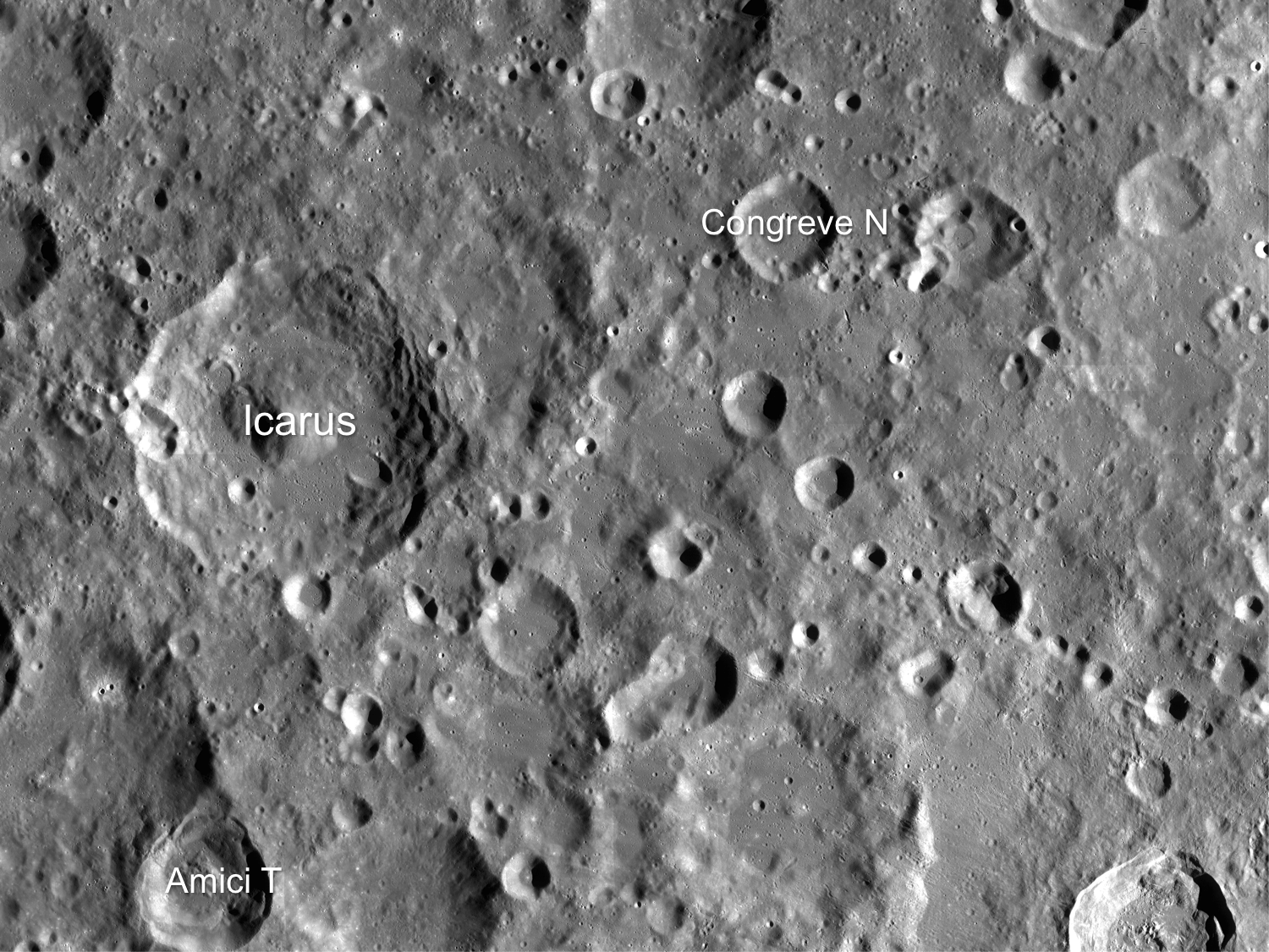
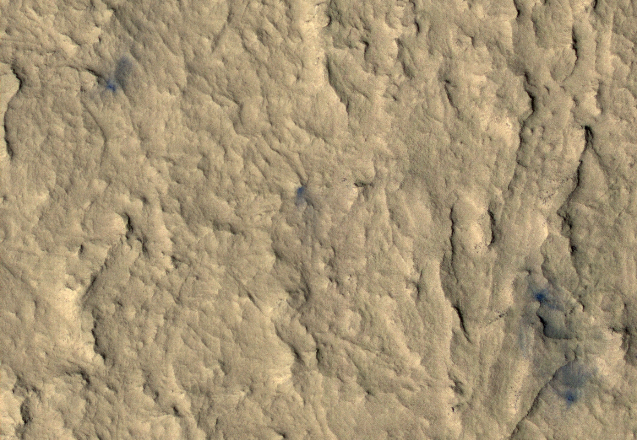
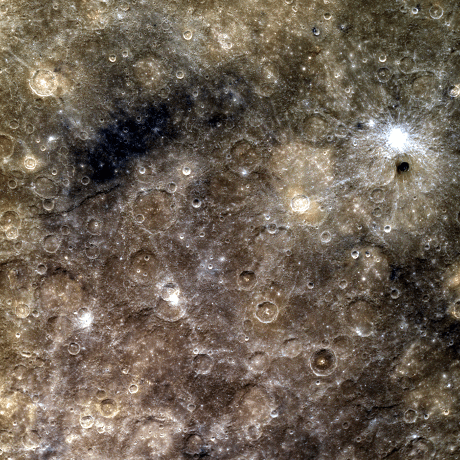
This scene lies between Mercury’s Moody and Amaral craters, spanning an area of about 1200 km (745 miles). The patch of dark blue Low Reflectance Material (LRM) in the upper left of the image and the bright rayed crater on the right make this a diverse view of Mercury’s surface. Note the curious small, dark crater just below the bright rayed crater on the right.

Dark LRM material is thought to indicate the presence of a mineral called ilmenite, which is composed of iron and titanium and has been revealed through volcanic, cratering and erosion processes.

More Mercury images: Postcards from the (Inner) Edge

Did you know that until MESSENGER arrived in 2008 half of Mercury had never been seen? And that although Mercury is the closest planet to the Sun there may still be water ice on its surface? Learn more about these and other fascinating facts about Mercury here.

Image: NASA/Johns Hopkins University Applied Physics Laboratory/Carnegie Institution of Washington


Loads of Ice Waiting for Explorers at the Moon’s Shackleton Crater

Shackleton crater on the Moon’s south pole has been somewhat of an enigma, as its permanently shadowed interior has made it difficult to detect what is inside. But with new observations using the laser altimeter on the Lunar Reconnaissance Orbiter (LRO) spacecraft, a team of researchers has essentially illuminated the crater’s interior with laser light, measuring its albedo, or natural reflectance. The scientists found that the crater’s floor is quite bright, an observation consistent with the presence of ice. In fact, ice may make up 22 percent of the material on the crater floor, with possibly more ice embedded within the crater walls.

“We decided we would study the living daylights out of this crater,” said Maria Zuber from the Massachuesetts Institute of Technology, who lead a team to study Shackleton Crater. “From the incredible density of observations we were able to make an extremely detailed topographic map.”

For laser altimeter observations, elevation maps can be created by measuring the time it takes for laser light to bounce down to the Moon’s surface and back to the instrument. The longer it takes, the lower the terrain’s elevation. Using these measurements, the group mapped the crater’s floor and the slope of its walls.

The team used over 5 million measurements to create their detailed map.


While the crater’s floor was relatively bright, Zuber and her colleagues observed that its walls were even brighter. The finding was at first puzzling. Scientists had thought that if ice were anywhere in a crater, it would be on the floor, where no direct sunlight penetrates. The upper walls of Shackleton crater are occasionally illuminated, which could evaporate any ice that accumulates. A theory offered by the team to explain the puzzle is that “moonquakes”– seismic shaking brought on by meteorite impacts or gravitational tides from Earth — may have caused Shackleton’s walls to slough off older, darker soil, revealing newer, brighter soil underneath. Zuber’s team’s ultra-high-resolution map provides strong evidence for ice on both the crater’s floor and walls.

“There may be multiple explanations for the observed brightness throughout the crater,” said Zuber. “For example, newer material may be exposed along its walls, while ice may be mixed in with its floor.”

The crater, named after the Antarctic explorer Ernest Shackleton, is nearly 20 km (more than 12 miles) wide and over 3 km (2 miles) deep — about as deep as Earth’s oceans. Zuber described the crater’s interior as “extremely rugged … It would not be easy to crawl around in there.”

She added that the new topographic map will help researchers understand crater formation and study other uncharted areas of the moon.

“I will never get over the thrill when I see a new terrain for the first time,” Zuber said. “It’s that sort of motivation that causes people to explore to begin with. Of course, we’re not risking our lives like the early explorers did, but there is a great personal investment in all of this for a lot of people.”

Ben Bussey, staff scientist at Johns Hopkins University’s Applied Physics Laboratory, said the new evidence for ice in Shackleton crater may indeed help determine the course for future lunar missions.

“Ice in the polar regions has been sort of an enigmatic thing for some time … I think this is another piece of evidence for the possibility of ice,” Bussey says. “To truly answer the question, we’ll have to send a lunar lander, and these results will help us select where to send a lander.”

And for any humans explorers, a crater like Shackleton at the lunar poles may well be the best location for a base, as the poles contain regions of near-permanent sunlight needed for power, and regions of near-permanent darkness containing ice — both of which would be essential resources for any lunar colony.

The team’s research was published today in the Journal Nature.

Sources: MIT, NASA

Lead image caption: Elevation (left) and shaded relief (right) image of Shackleton, a 21-km-diameter (12.5-mile-diameter) permanently shadowed crater adjacent to the lunar south pole. The structure of the crater’s interior was revealed by a digital elevation model constructed from over 5 million elevation measurements from the Lunar Orbiter Laser Altimeter. Credit: NASA/Zuber, M.T. et al., Nature, 2012

Second image caption: This is an elevation map of Shackleton crater made using LRO Lunar Orbiter Laser Altimeter data. The false colors indicate height, with blue lowest and red/white highest. Credit: NASA/Zuber, M.T. et al., Nature, 2012