Antarctica’s Ice Being Eaten Away From Below

The 820-foot-wide crack in Antarctica's Pine Island Glacier, seen from DC-8 during Operation IceBridge (Credit: NASA/DMS)


Data collected from a NASA ice-watching satellite reveal that the vast ice shelves extending from the shores of  western Antarctica are being eaten away from underneath by ocean currents, which have been growing warmer even faster than the air above.

The animation above shows the circulation of ocean currents around the western Antarctic ice shelves. The shelf thickness is indicated by the color; red is thicker (greater than 550 meters), while blue is thinner (less than 200 meters).

Launched in January 2003, NASA’s ICESat (Ice, Cloud and land Elevation Satellite) studied the changing mass and thickness of Antarctica’s ice from its location in polar orbit. An international research team used over 4.5 million surface height measurements collected by ICESat’s GLAS (Geoscience Laser Altimeter System) instrument from Oct. 2005 to 2008. They concluded that 20 of the 54 shelves studied — nearly half — were losing thickness from underneath.

[/caption]

Most of the melting ice shelves are located in west Antarctica, where the flow of inland glaciers to the sea has also been accelerating — an effect that can be compounded by thinning ice shelves which, when grounded to the offshore seabed, serve as dams to hold glaciers back.

Melting of ice by ocean currents can occur even when air temperature remains cold, maintaining a steady process of ice loss — and eventually increased sea level rise.

“We can lose an awful lot of ice to the sea without ever having summers warm enough to make the snow on top of the glaciers melt,” said Hamish Pritchard of the British Antarctic Survey in Cambridge and the study’s lead author . “The oceans can do all the work from below.”

The study also found that Antarctica’s winds are shifting in response to climate change.

“This has affected the strength and direction of ocean currents,” Pritchard said. “As a result warm water is funnelled beneath the floating ice. These studies and our new results suggest Antarctica’s glaciers are responding rapidly to a changing climate.”

ICESat completed operations in 2010 and was decommissioned in August of that year. Its successor ICESat-2 is anticipated to launch in 2016.

Read more on NASA’s news release here.

Animation credit: NASA/Goddard CGI Lab

Salty Soil on Mars Could Be Slurping Water from the Atmosphere

This image provided by NASA shows a scraped area on Mars known as "Snow White," photographed on July 8. Two samples from Snow White were delivered to the Phoenix Mars Lander's wet-chemistry lab, and tests turned up evidence of perchlorate. Credit: NASA/JPL/University of Arizona

[/caption]

It happens every summer in humid air: the salt in your salt shaker clumps together as the salt draws in the water from the air. Researchers have found this happens even in the frigid but dry McMurdo Dry Valley in Antarctica, a cold, polar desert. The sandy, salty soils there are frequently dotted with moist patches in the spring despite a lack of snowmelt and no possibility of rain. What was discovered is that the salty soils in the region actually suck moisture out of the atmosphere. Salty soils were found on Mars’ polar region by the Phoenix lander, so could the same thing be happening on the Red Planet, creating a salt brine within Mars’ soil? And if so what are the implications for life forming there?

Joseph Levy, a post-doctoral researcher from Oregon State University said it takes a combination of the right kinds of salts and sufficient humidity to make the process work. But those ingredients are present on Mars.

“If you have sodium chloride, or table salt, you may need a day with 75 percent humidity to make it work,” he added. “But if you have calcium chloride, even on a frigid day, you only need a humidity level above 35 percent to trigger the response.”

The soils in Antarctica have salt from sea spray and from ancient fjords that flooded the region. With enough humidity, those salty soils suck the water right out of the air, forming a brine, Levy said, that will keep collecting water vapor until it equalizes with the atmosphere.

Levy and his colleagues, from Portland State University and Ohio State University, found that the wet soils created by this phenomenon were 3-5 times more water-rich than surrounding soils – and they were also full of organic matter, including microbes, which they said could enhance the potential for life on Mars. The elevated salt content also depresses the freezing temperature of the groundwater, which continues to draw moisture out of the air when other wet areas in the valleys begin to freeze in the winter.

Though Mars, in general, has lower humidity than most places on Earth, studies have shown that it is sufficient to reach the thresholds that Levy and his colleagues have documented in Antarctica.

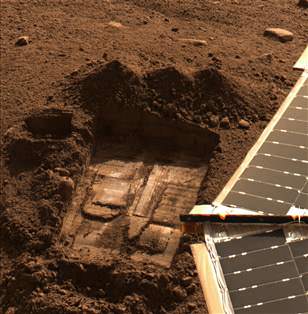
The parallels of what was found by the Mars Phoenix team is striking. The salty perchlorates found on Mars by the Phoenix lander also strongly attracts water and makes up a few tenths of a percent of the composition in all three soil samples analyzed by Phoenix’s wet chemistry laboratory. Principal investigator of the Phoenix mission, Peter Smith from the University of Arizona, Tucson, said the perchlorates could pull humidity from the Martian air.

A paper about Phoenix water studies, led by Smith, cites clues supporting an interpretation that the soil has had films of liquid water in the recent past. The evidence for water and potential nutrients “implies that this region could have previously met the criteria for habitability” during portions of continuing climate cycles.

At higher concentrations, it might combine with water as a brine that stays liquid at Martian surface temperatures. Some microbes on Earth use perchlorate as food, and future human explorers on Mars might find it useful as rocket fuel or for generating oxygen.

Levy and his team discovered the mysterious patches of wet soil in Antarctica, and then explored the causes. Through soil excavations and other studies, they eliminated the possibility of groundwater, snow melt, and glacial runoff. Then they began investigating the salty properties of the soil, and discovered that the McMurdo Dry Valleys weather stations had reported several days of high humidity earlier in the spring, leading them to their discovery of the vapor transfer.

“It seems kind of odd, but it really works,” Levy said. “Before one of our trips, I put a bowl of the dried, salty soil and a jar of water into a sealed Tupperware container and left it on my shelf. When I came back, the water had transferred from the jar to the salt and created brine.

“I knew it would work,” he added with a laugh, “but somehow it still surprised me that it did.”

The salty soils also are present on the Red Planet, which makes the upcoming landing of the Mars Science Laboratory this summer even more tantalizing.
Evidence of the salty nature of the McMurdo Dry Valleys is everywhere, Levy said. Salts are found in the soils, along seasonal streams, and even under glaciers. Don Juan Pond, the saltiest body of water on Earth, is found in Wright Valley, the valley adjacent to the wet patch study area.

“The conditions for creating this new water source into the permafrost are perfect,” Levy said, “but this isn’t the only place where this could or does happen. It takes an arid region to create the salty soils, and enough humidity to make the transference work, but the rest of it is just physics and chemistry.”

The study by Levy and his team was published online this week in the journal Geophysical Research Letters.

Sources: University of Oregon, previous article about the Phoenix Lander

Antarctica Gives NASA Satellite The Ol’ Frazil Dazzle

Tendrils of ice particles, called frazil, extend out into Antarctica's Mackenzie Bay. (NASA/EO-1 - ALI)

[/caption]

Ghostly green tendrils drift out into Mackenzie Bay off the coast of eastern Antarctica in this image, acquired by NASA’s Earth-Observing (EO-1) satellite on Feb. 12, 2012.

The tendrils are made of fine particles of ice called frazil, the result of upwelling cold water from deep beneath the Amery ice shelf.

Sea water flowing in currents under the Amery ice shelf gets cooled to temperatures below freezing, the result of greater water pressures existing at depth. As some of the water rises and flows along the underside of the shelf toward the open ocean, it gradually encounters less pressure since the ice thickness decreases the further away from shore it extends.

When the supercold water approaches the surface where pressure is lowest, it instantly freezes, forming needle-like ice particles called frazil.

Only 3 -4 millimeters wide, the frazil crystals can still be concentrated enough to be visible from orbit as it drifts into the bay, flowing around icebergs as it is carried along by wind and currents. (The largest iceberg in the image is a little over 4 km/2.5 miles long.)

Eventually the warmer surface water that surrounds the southern continent melts the frazil, and the tendrils fade away.

Scheduled to fly for a year and only designed to last a year and a half, EO-1 celebrated its eleventh anniversary on November 21, 2011. During its time in orbit the satellite has accomplished far more than anyone dreamed, and its Earth-observing mission continues on. Read more on the EO-1 site here.

Black Friday’s Secret Solar Eclipse

Annular solar eclipse observed by the Hinode spacecraft on Jan. 6, 2011. Credit: Hinode/XRT

[/caption]

While many in the U.S. will be recovering from Thanksgiving day meals and looking for ways to stretch their holiday shopping dollars at (hopefully local) retailers’ “Black Friday” sales, the face of the Sun will grow dark as the Moon passes in front of it, casting its shadow over the Earth. But it won’t be visible to American shoppers – or very many people at all, in fact… this eclipse will be hiding in the southern skies above Antarctica!

Visibility of Nov. 25 2011 annular eclipse. NASA GFSC

On Friday, November 25, an annular eclipse will occur, reaching a maximum coverage at 06:20:17 UT of magnitude .905. It will be the largest – and last – partial eclipse of the year.

But its visibility will be limited to the most southern latitudes… outside of the Antarctic continent, only New Zealand, Tasmania and parts of South Africa will have any visibility of the event.

An annular eclipse is similar to a total eclipse, except that the Moon is at a further distance from Earth in its orbit and so does not completely cover the disc of the Sun. Instead a bright ring of sunlight remains visible around the Moon’s silhouette, preventing total darkness.

The next solar eclipse will occur on May 20, 2012. It will also be annular, and even darker than the Black Friday one at a magnitude of .944. It will be visible from China, Japan, the Pacific and Western U.S.

Following that, the main event of 2012 would have to be a total eclipse on November 13, which will be visible from Australia, New Zealand and South America (greatest totality will occur over the South Pacific.) Several sites have already set up group travel events to witness it!

Feeling left out on cosmic occultations? Not to worry… there will be a very visible total lunar eclipse on the night of December 10, 2011 (weather permitting, of course) to viewers across the Northern Hemisphere. The Moon will pass into Earth’s shadow, turning gradually darker in the night sky until it is colored a deep rusty red. It’s a wonderful event to watch, even if not as grandiose as a total eclipse of the Sun.

(Plus it’s completely safe to look at, as opposed to solar eclipses which should never be directly observed without safety lenses or some projection device… for the same reasons that you shouldn’t stare at the Sun normally.)

For a listing of past and future eclipses, both solar and lunar, visit Mr. Eclipse here. And you can read more about the Nov. 25 eclipse on AstroGuyz.com.


From the Land of Ice and Snow

Ice-coated mountaintops of Alexander Island, one of the largest islands off Antarctica. Credit: Michael Studinger/NASA.

[/caption]

Views from the window of NASA’s DC-8 reveal sweeping expanses of ice and rock as part of the ongoing 2011 Operation IceBridge survey of Antarctica’s ice cover.

Now in its third season, Operation IceBridge is a six-year-long mission to study the dynamics of the Antarctic and Arctic ice sheets. It’s the largest ever aerial survey of the polar ice and will yield valuable data on the state of Earth’s vast reservoirs of frozen water, including the land and sea underneath and how they are being affected by today’s rapidly changing climate.

The ridges of the Shackleton Range cast shadows onto Antarctica's ice. Credit: Michael Studinger/NASA.

Researchers – like Michael Studinger, who took the incredible photos seen here –  fly over Greenland during the months of March through May and over Antarctica in October and November. NASA’s instrument-laden DC-8 flies over these remote locations at a low altitude of about 1,500 feet, often with little or no advance weather data.

98 percent of Antarctica is covered with ice. Information obtained by Operation IceBridge will be combined with satellite data to create the most accurate models possible of Antarctic ice loss and how it will affect future sea level rise.

Mountains piled with snow and ice rise above the clouds on Alexander Island. Credit: Michael Studinger/NASA.

This season’s Antarctic IceBridge campaign features NASA’s DC-8, at 157 feet long the largest plane in the agency’s airborne research fleet, and will also feature the debut of the Gulfstream V (G-V) operated by the National Science Foundation and National Center for Atmospheric Research.

While the DC-8 flies at low altitudes, the G-V will fly above 30,000 feet to utilize its Land, Vegetation and Ice Sensor (LVIS), which makes detailed topographic studies of the surface.

“With IceBridge, our aim is to understand what the world’s major ice sheets could contribute to sea-level rise. To understand that you have to record how ice sheets and glaciers are changing over time.”

– Michael Studinger, IceBridge project scientist at NASA’s Goddard Space Flight Center in Greenbelt, Md.

The wing of NASA's DC-8 cuts across the frozen expanse of the Brunt Ice Shelf, with its 100-foot-high cliff face. Credit: Michael Studinger/NASA.

Read more about Operation IceBridge here.

Antarctic Micrometeorites Provide Clues to Solar System Formation

The extraction of clean snow from a trench near the CONCORDIA Antarctic station. Image courtesy of J. Duprat CSNSM-CNRS

[/caption]

Researchers sifting through the pristine, cold snow in Antarctica have found micrometeorites that contain a bit of a surprise. The two micrometeorites, known as particles 19 and 119, contain extremely large amounts of carbon as well as excesses of deuterium. While this high organic content usually comes from distant interstellar space where molecular clouds gather to form new stars, other clues say these space rocks likely formed in our own solar system. This contradicts long-held notions that that all organic matter with extreme deuterium excesses have interstellar origins. Additionally, the meteorites could provide information about the protplanetary disk that formed our solar system.

(A) 
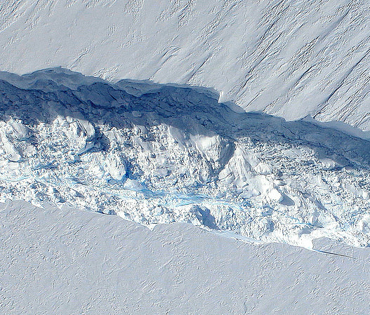
Backscattered scanning electron micrograph of particle 119. The carbon-rich areas appear dark (arrows); the bright inclusions are dominated by Fe-Ni sulfides and silicates. (B) High-resolution TEM image of particle 19. (C) Bright-field TEM image of particle 19. The lacey carbon film (13) is indicated as black arrows; the crystalline phases are Mgrich olivines (ol), Mg-rich pyroxenes (px), and Fe-Ni sulfides (S); OM, organic matter. Glassy aggregates (GEMS candidates) are highlighted in black squares (13). Image courtesy of Science/AAAS

Jean Duprat and colleagues working at the CONCORDIA polar station located in central Antarctica recovered the two micrometeorites from 40 to 55 year-old snow. In investigating their make-up to determine where they came from, the researchers identified crystalline materials embedded in particles 19 and 119 that indicate that they formed close to our sun, and much more recently than predicted.

Their findings imply that these well-preserved micrometeorites contain a record of the cold regions of our sun’s ancient proto-planetary disk, which eventually led to the formation of our solar system.

More studies of these and other meteorites could possibly reveal details of the first deliveries of organic materials to the primitive Earth.

The findings have been published in this week’s edition of Science.

Unexpected Life Found Under Antarctic Ice

Researchers in Antarctica got a surprise visit from a creature in a borehole 185 meters (600 feet) below the Antarctic ice, where there is usually no light. A Lyssianasid amphipod, a shrimp-like creature can be seen swimming in this video. A NASA team had lowered a small video camera to get the first-ever photograph of the underside of an ice shelf when the curious little 7 cm (3- inch) shrimp stopped by to check out the equipment. Scientists say this could challenge the idea of where and how forms of life can survive. Anyone else thinking Europa?
Continue reading “Unexpected Life Found Under Antarctic Ice”

Antarctica Pictures

Antarctica
Composite satellite image of Antarctica, the location of the largest desert on Earth. Credit: NASA/Dave Pape

Antarctica is one of the most remote places on Earth, and extremely difficult to visit. But there are many spacecraft constantly watching the southern continent, studying its climate and geography. Here are some amazing Antarctica pictures from space.

Here’s a picture of the entire continent of Antarctica seen from space. It was captured piece by piece by several spacecraft, and then stitched together into this amazing mosaic image.

Regional View Of Victoria Land, Antartica

This is a close up view of Victoria Land, in Antarctica. It’s a region of the continent that’s bounded by the Ross Sea, and it was discovered by James Clark Ross.

Close Up View Of Don Juan Pond, Antartica

This is a photo of Don Juan Pond, a tiny, extremely salty lake in Antarctica. It has a greater salinity than the Dead Sea or Lake Assal. It’s estimated to be about 30 times saltier than the ocean. It’s the only lake in Antarctica that never freezes.

Bellingshausen Sea, Antarctica

This is an image of the Bellingshausen Sea in Antarctica. It’s hard to see which parts of this image are over the ocean, and which parts are over the land.

Larsen Ice Shelf, Antartica

This photograph shows the break up of the Larsen Ice Shelf in 2001.

We’ve written many articles about Antarctica for Universe Today. Here’s an article about an unusual micrometeorite found in Antarctica, and here’s an article about an extremophile hunt in Antarctica.

If you’d like more info on Antarctica, check out the LIMA Mosaic Images of Antarctica site, and here’s a nice photo of the entire continent.

We’ve recorded several episodes of Astronomy Cast about Earth. Listen here, Episode 51: Earth.