New Way to Measure Curvature of Space Could Unite Gravity Theory

The curvature of space due to gravity.

[/caption]
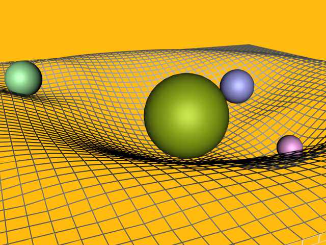
Einstein’s general theory of relativity describes gravity in terms of the geometry of both space and time. Far from a source of gravity, such as a star like our sun, space is “flat” and clocks tick at their normal rate. Closer to a source of gravity, however, clocks slow down and space is curved. But measuring this curvature of space is difficult. However, scientists have now used a continent-wide array of radio telescopes to make an extremely precise measurement of the curvature of space caused by the Sun’s gravity. This new technique promises to contribute greatly in studying quantum physics.

“Measuring the curvature of space caused by gravity is one of the most sensitive ways to learn how Einstein’s theory of General Relativity relates to quantum physics. Uniting gravity theory with quantum theory is a major goal of 21st-Century physics, and these astronomical measurements are a key to understanding the relationship between the two,” said Sergei Kopeikin of the University of Missouri.

Kopeikin and his colleagues used the National Science Foundation’s Very Long Baseline Array (VLBA) radio-telescope system to measure the bending of light caused by the Sun’s gravity to within one part in 30,000 3,333 (corrected by NRAO and updated here on 9/03/09 — see this link provided by Ned Wright of UCLA for more information on deflection and delay of light). With further observations, the scientists say their precision technique can make the most accurate measure ever of this phenomenon.

Bending of starlight by gravity was predicted by Albert Einstein when he published his theory of General Relativity in 1916. According to relativity theory, the strong gravity of a massive object such as the Sun produces curvature in the nearby space, which alters the path of light or radio waves passing near the object. The phenomenon was first observed during a solar eclipse in 1919.

Though numerous measurements of the effect have been made over the intervening 90 years, the problem of merging General Relativity and quantum theory has required ever more accurate observations. Physicists describe the space curvature and gravitational light-bending as a parameter called “gamma.” Einstein’s theory holds that gamma should equal exactly 1.0.

“Even a value that differs by one part in a million from 1.0 would have major ramifications for the goal of uniting gravity theory and quantum theory, and thus in predicting the phenomena in high-gravity regions near black holes,” Kopeikin said.

To make extremely precise measurements, the scientists turned to the VLBA, a continent-wide system of radio telescopes ranging from Hawaii to the Virgin Islands. The VLBA offers the power to make the most accurate position measurements in the sky and the most detailed images of any astronomical instrument available.

Sun's Path in Sky in Front of Quasars, 2005. Credit: NRAO

The researchers made their observations as the Sun passed nearly in front of four distant quasars — faraway galaxies with supermassive black holes at their cores — in October of 2005. The Sun’s gravity caused slight changes in the apparent positions of the quasars because it deflected the radio waves coming from the more-distant objects.

The result was a measured value of gamma of 0.9998 +/- 0.0003, in excellent agreement with Einstein’s prediction of 1.0.

“With more observations like ours, in addition to complementary measurements such as those made with NASA’s Cassini spacecraft, we can improve the accuracy of this measurement by at least a factor of four, to provide the best measurement ever of gamma,” said Edward Fomalont of the National Radio Astronomy Observatory (NRAO). “Since gamma is a fundamental parameter of gravitational theories, its measurement using different observational methods is crucial to obtain a value that is supported by the physics community,” Fomalont added.

Kopeikin and Fomalont worked with John Benson of the NRAO and Gabor Lanyi of NASA’s Jet Propulsion Laboratory. They reported their findings in the July 10 issue of the Astrophysical Journal.

Source: NRAO

Satellite Images of California Wildfires, Mt. Wilson Update

NASA's Aqua Satellite MODIS Instrument view of the California wildfires. Credit: NAS

[/caption]
The wildfires near Los Angeles have spread to over 100,000 acres. The Los Angeles Times reported that the fire had burned 74 structures and remained out of control, spreading both west and north. As of 6:30 p.m. Pacific Daylight Time on August 31, some 12,000 homes were threatened. Fire fighters struggled to save the Mt. Wilson Observatory from the encroaching fire. Today, fire fighters set controlled backfires in effort to remove the closest vegetation to the various telescope structures. See below for a labeled image of the structures on Mt. Wilson amid smoke from the fires, courtesy of Emily Lakdawalla of the Planetary Society, along with more satellite, ground and helicopter images from the fires.

Mt. Wilson with labeled names of scopes. Courtesy of Emily Lakdawalla

Imagery from Mt. Wilson’s tower camera, recently went offline, likely due to loss of power. They have a back up site, available here, and staff from the observatory are still posting updates. While it was alarming to see the observatory structures surround and sometimes not visible because of smoke, the Mt. Wilson staff assured that they structures were still safe, and the fires were planned:

The [fire fighter’s] plan, which they would have implemented earlier had they not been withdrawn, was to start these groundlevel fire and literally walk along with them to keep them controlled. This is why we see no flames. The fires will consume the accumulation of needles from the many pine and fir trees as well as other scrub growth that could flame up and ignite lower limbs that would them permit the blossoming of the entire tree into flames. All the smoke we see is entirely consistent with this procedure. Larry and Dave are both delighted to see what’s going on, but I’ve got to say that seeing smoke next to those domes is very unsettling to me. Still, I know what the fire fighters are now doing is necessary to save the Observatory.

The latest news is that 4 acres of water is going to be dropped on the north side of Mt.W towers on Tuesday afternoon in an effort to save the observatory and communications towers.

A live view from a helicopter from station KTLA is available here. UPDATE: That feed is cutting out frequently due to demand. Try this one instead. (It is from a Fox station from anyone who thinks I have something against Fox….)

View this link to see a map of where the fire has spread. It is a Google map that is updated frequently.

The Los Angeles times blog reports that the “Station” fire, as it is called, in Angeles National Forest has been creeping east, toward the center of the San Gabriel Mountains. But its growth has been slower in the last 24 hours than it was over the weekend, thanks to higher humidity.

The fire’s maximum borders are roughly 25 miles from west to east and 18 miles north to south, covering the entire length of Angeles National Forest.

This image from NASA’s GOES-O satellite shows how far the smoke from the fires has spread.

GOES O image of smoke from the California fires, reaching nearly across Nevada. Credit: NASA

Image from NASA's Terra Satellite, taken August 30, 2009. Credit: NASA

This image was acquired mid-morning on Aug. 30 by the backward (northward)-viewing camera of the Multi-angle Imaging SpectroRadiometer (MISR) instrument on NASA’s Terra satellite. The image is shown in an approximate perspective view at an angle of 46 degrees off of vertical. The area covered by the image is 245 kilometers (152 miles) wide. Several pyrocumulus clouds, created by the Station Fire, are visible above the smoke plumes rising from the San Gabriel Mountains north of Los Angeles in the left-center of the image. Smoke from the Station fire is seen covering the interior valleys along the south side of the San Gabriel Mountains, along with parts of the City of Los Angeles and Orange County, and can be seen drifting for hundreds of kilometers to the east over the Mojave Desert.

This striking time-lapse video of the fires at sunset, taken on August 29 from Mulhulland Drive in Los Angeles, show the fires spreading.

Sources: Mt. Wilson observatory website fire update, Los Angeles Times, New York Times, NASA Earth Observatory

Watch Saturn’s Rings Disappear (Video)

Composite image of Saturn over 6 years. Credit: Alan Friedman

On September 4, 2009, Earth’s orbital motion will carry it through the same plane as Saturn’s rings. From our vantage point, the rings will disappear. Usually these ring plane crossings — which only happen about every 15 years — are great opportunities to observe Saturn’s moons. But this year’s ring plane crossing will be practically impossible to see, as Saturn will be very close to the sun, only 11 degrees away. So, disappointingly, we won’t see much. However, amateur astronomer Alan Friedman has given us a glimpse of what this event will look like, without the glare from the sun. Friedman has put together an animation of how the angle of Saturn’s rings have changed over the past six years. See the animation below. “It shows the changing plane of the ring system as viewed from my Buffalo backyard from 2004 to 2009,” said Friedman. “The final frame has been assembled from earlier 2009 observations to display how the planet will appear with its rings edge on.” Gorgeous!

6 years of Saturn observations were combined to create this animation showing the changing plane of the ring system as viewed from earth. Credit: Alan Friedman

But, Friedman says, our real view of Saturn should get much better and provide a real treat this autumn. “In the fall of 2009, Saturn will emerge from the glare of the sun in the early morning sky and provide Earth-bound astronomers with our first glimpse of its blue north pole in 14 years,” he said.

Enjoy perusing Friedman’s impressive gallery on his website.

And thanks, Alan, for sharing your six-year endeavor with Universe Today!

After Loss of Lunar Orbiter, India Looks to Mars Mission

India Moon Mission
Artist concept of Chandrayaan-1 orbiting the moon. Credit: ISRO

[/caption]
After giving up on re-establishing contact with the Chandrayaan-1 lunar orbiter, Indian Space Research Organization (ISRO) Chairman G. Madhavan Nair announced the space agency hopes to launch its first mission to Mars sometime between 2013 and 2015. Nair said the termination of Chandrayaan-1, although sad, is not a setback and India will move ahead with its plans for the Chandrayaan-2 mission to land an unmanned rover on the moon’s surface to prospect for chemicals, and in four to six years launch a robotic mission to Mars.


“We have given a call for proposal to different scientific communities,” Nair told reporters. “Depending on the type of experiments they propose, we will be able to plan the mission. The mission is at conceptual stage and will be taken up after Chandrayaan-2.”

On the decision to quickly pull the plug on Chandrayaan-1, Nair said, “There was no possibility of retrieving it. (But) it was a great success. We could collect a large volume of data, including more than 70,000 images of the moon. In that sense, 95 percent of the objective was completed.”

Contact with Chandrayaan-1 may have been lost because its antenna rotated out of direct contact with Earth, ISRO officials said. Earlier this year, the spacecraft lost both its primary and back-up star sensors, which use the positions of stars to orient the spacecraft.

The loss of Chandrayaan-1 comes less than a week after the spacecraft’s orbit was adjusted to team up with NASA’s Lunar Reconnaissance Orbiter for a Bi-static radar experiment. During the maneuver, Chandrayaan-1 fired its radar beam into Erlanger Crater on the moon’s north pole. Both spacecraft listened for echoes that might indicate the presence of water ice – a precious resource for future lunar explorers. The results of that experiment have not yet been released.

Chandrayaan-1 craft was designed to orbit the moon for two years, but lasted 315 days. It will take about 1,000 days until it crashes to the lunar surface and is being tracked by the U.S. and Russia, ISRO said.

The Chandrayaan I had 11 payloads, including a terrain-mapping camera designed to create a three-dimensional atlas of the moon. It is also carrying mapping instruments for the European Space Agency, radiation-measuring equipment for the Bulgarian Academy of Sciences and two devices for NASA, including the radar instrument to assess mineral composition and look for ice deposits. India launched its first rocket in 1963 and first satellite in 1975. The country’s satellite program is one of the largest communication systems in the world.

Sources: New Scientist, Xinhuanet

Is The Milky Way Doomed By Galactic Bombardment?

This image from a supercomputer simulation shows the density of dark matter in our Milky Way galaxy which is known to contain an ancient thin disk of stars. Brightness (blue-to-violet-to-red-to-yellow) corresponds to increasing concentration of dark matter.

[/caption]

As scientists attempt to learn more about how galaxies evolve, an open question has been whether collisions with our dwarf galactic neighbors will one day tear apart the disk of the Milky Way.

That grisly fate is unlikely, a new study now suggests.

While astronomers know that such collisions have probably occurred in the past, the new computer simulations show that instead of destroying a galaxy, these collisions “puff up” a galactic disk, particularly around the edges, and produce structures called stellar rings.

The finding solves two mysteries: the likely fate of the Milky Way at the hands of its satellite galaxies — the most massive of which are the Large and Small Magellanic Clouds — and the origin of its puffy edges, which astronomers have seen elsewhere in the universe and dubbed “flares.”

The mysterious dark matter that makes up most of the universe plays a role, the study found.

Astronomers believe that all galaxies are embedded within massive and extended halos of dark matter, and that most large galaxies lie at the intersections of filaments of dark matter, which form a kind of gigantic web in our universe. Smaller satellite galaxies flow along strands of the web, and get pulled into orbit around large galaxies such as our Milky Way.

Ohio State University astronomer Stelios Kazantzidis and his colleagues performed detailed computer simulations of galaxy formation to determine what would happen if a satellite galaxy — such as the Large Magellanic Cloud and its associated dark matter — collided with a spiral galaxy such as our own.

The researchers considered the impacts of many different smaller galaxies onto a larger, primary disk galaxy. They calculated the likely number of satellites and the orbital paths of those satellites, and then simulated what would happen during collision, including when the dark matter interacted gravitationally with the disk of the spiral galaxy.

The conclusion?  None of the disk galaxies were torn apart.  To the contrary, the primary galaxies gradually disintegrated the in-falling satellites, whose material ultimately became part of the larger galaxy.  The satellites passed through the galactic disk over and over, and on each pass, they would lose some of their mass, a process that would eventually destroy them completely.

Though the primary galaxy survived, it did form flared edges which closely resembled our galaxy’s flared appearance today.

Does that settle the question of the fate of the Milky Way?

Kazantzidis couldn’t offer a 100-percent guarantee.

“We can’t know for sure what’s going to happen to the Milky Way, but we can say that our findings apply to a broad class of galaxies similar to our own,” Kazantzidis said. “Our simulations showed that the satellite galaxy impacts don’t destroy spiral galaxies — they actually drive their evolution, by producing this flared shape and creating stellar rings — spectacular rings of stars that we’ve seen in many spiral galaxies in the universe.”

Source: Ohio State University

What are Divergent Boundaries?

Pangaea
Pangea animation

Divergent boundaries are one of the bi-products of plate tectonics. As the name implies, divergent boundaries are formed when two adjacent tectonic plates separate, i.e., when they diverge.

When tectonic plates start to diverge, the linear feature formed is called a rift. Sometimes, the gap widens and sometimes it stops. When the gap eventually widens, it then evolves into a rift valley. Divergent boundaries that occur between oceanic plates produce mid-oceanic ridges.

In places where molten lava is able to move up and fill the gap, volcanic islands are eventually formed. Molten lava that rises eventually cools and forms part of the ocean floor.

One divergent boundary is the Mid-Atlantic Ridge, found at the bottom of the Atlantic and is the longest mountain range in the world. That’s right, the longest mountain range is hidden from our view. Imagine how astonished crew members of the HMS Challenger were when they discovered the massive rise underneath them. The Challenger expedition was dedicated to scientific discoveries the became foundations of oceanography. The Mid-Atlantic Ridge was observed by the HMS Challenger in 1872.

The record for the slowest divergent boundary in the world goes to Gakkel Ridge between the North American Plate and the Eurasian Plate in the Arctic Ocean. Its annual rate of separation is less than one centimeter – that’s about half as fast the rate your fingernails grow. Robotic submersibles belonging to the AGAVE expedition discovered microbial communities of over a dozen new species on this ridge.

Although not as common, rift valleys can also be formed on land. One example is the Basin and Range province in Nevada and Utah. The world’s largest freshwater lakes such as Siberia’s Lake Baikal and East Africa’s Lake Tanganyika are found in rift valleys.

One of the favorite natural laboratories for the study of divergent plate boundaries is Iceland. The Mid-Atlantic Ridge runs beneath Iceland and as the North American Plate moves westward while the Eurasian Plate moves eastward, Iceland will slowly be sliced in half. When water rushes in to fill the widening gap, this huge island of ice will form two smaller islands.

How far can divergent boundaries go? Well if we look at a time frame of 100 to 200 million years, we can easily spot the Atlantic Ocean. What is believed to have been a tiny inlet of water between the formerly merged Europe, Africa, and Americas has now evolved into this vast expanse of water.

You can read more about divergent boundaries here in Universe Today. Here are the links:

There’s more about it at USGS. Here are a couple of sources there:

Here are two episodes at Astronomy Cast that you might want to check out as well:

Sources:
Plate Boundaries
http://pubs.usgs.gov/gip/dynamic/understanding.html
http://en.wikipedia.org/wiki/Divergent_boundary
http://geology.com/nsta/divergent-plate-boundaries.shtml

Astronaut Helmet

Astronaut Suit
lunar-spacesuits. Image credit: NASA

The astronaut helmet protects its wearer from micrometeoroids, solar ultraviolet as well as infrared radiation. It is made up of the protective shell, neck ring, vent pad and feed port. Protection from radiation is actually provided by the Extravehicular Visor Assembly, which is fitted over the helmet.

A typical astronaut helmet like those worn in the Apollo missions is made of highly strengthened polycarbonate. Polycarbonate is a high impact-resistant plastic that you can also find in bulletproof glass and exterior automotive parts.

The neck ring mentioned above is a vital component in the pressure sealing feature of the astronaut’s outfit and attaches the helmet to the suit. The vent pad, which is fastened to the rear, has a recess that provides ventilation flow related functions. The feed port, on the other hand, supports the water and feed probes as well as the purge valve.

Today’s helmets have a built-in cam which allow us to see what they’re doing up there.

Both the helmet and suit provide protection from the dangerously low pressure of outer space. Without them, internal pressure in the astronaut’s body will push blood vessels and tissue outward.

Contrary to what Hollywood has portrayed in sci-fi films like Arnold Schwarzenegger’s Total Recall wherein bodies blow up when exposed to the vacuum of space, the effects are less sensational though. Nevertheless, full exposure to vacuum can still be harmful – lung damage being one of the side effects.

A lot of inconveniences accompany the wearing of an astronaut helmet. For example, you can’t just take it off to scratch a simple itch on your nose. To remedy this, a velcro patch is stuck on the inside to serve as a scratcher.

Also, since the helmet is fastened to the suit, astronauts who forget this end up facing its inner walls when they turn their heads. This can be quite annoying when they’d have to see panel switches above or at the sides from where they’re initially facing.

The problem gets even more complicated when they’re sitting. Since they’re strapped on their seats, astronauts can’t just lean back to face upward. If they want to turn their heads, they’d have to grab the helmet so they can make it turn to the desired direction.

Want to know what the most inconvenient predicament is? Space sickness or Space Adaptation Sickness (SAS) can strike even the most seasoned pilots, so imagine yourself as an astronaut having to puke right in the middle of a spacewalk. Still want to be the next Buzz Aldrin?

You can read more about astronaut helmet here in Universe Today. Here are the links:

There’s more about it at NASA. Here are a couple of sources there:

Here are two episodes at Astronomy Cast that you might want to check out as well:

Source: NASA

Bareket Observatory Celebrates International Year Of Astronomy


The Bareket Observatory in Israel just did something really remarkable – they celebrated the International Year of Astronomy with a live webcast for the entire world! During the event one could listen to live explanations by a U.S. astronomer and enjoying a special musical representation to those who are blind. I had very much been enjoying my conversations with Ido Bareket and had every intention of reminding our readers when the date was going to happen so you could join in… Then the storms hit Ohio.

Ido had invited me to help along with the live broadcast by being the US speaker and I’m glad he had the Internet “smarts” to know that satellite connections can easily be disrupted – because disrupted I became. Not only disrupted – but pretty much blown off the entire circuit. (Can you say open fields and lightning?) Anyhow, we’re back on board again here and although it’s past the date, you really need to take a look at how hard these folks are working towards global public outreach.

Bareket OutreachThe Bareket Observatory’s Remote Internet Telescope stays at work doing imaging. During their event the scope took in such sights such as nebulae, star clusters, planets, and asteroids – all captured in real-time and integrated into a static image. Like our own IYA scope, they keep records of their images and you can visit with all their past work by just clicking around on the site.

Bareket OutreachOne of the most awesome things I’ve ever seen done is their way of translating astronomical images for the vision impaired. Mr. Marty Quinn , at Design Rhythmics Sonification Research Lab has applied image sonification parameters to the images in the IYA 2009 Bareket Observatory Deep Space Images Webcast so those who are without sight were able to perceive the images as music. How did they do it? The image color was translated into a scale of 9 instruments using Bareket’s recent standard developed in the “Walk on the Sun” science exhibit. In general, since the images are in black and white, the main instrument that expresses the image color in this case is the piano – although many were used. Isn’t that an awesome way to reach everyone?!

Bareket OutreachOnce again, please take the time to visit Bareket Observatory’s Educational Pages and enjoy all the things they have to offer. The entire session is now available online as a V.O.D movie and this version for European viewers. It’s a great opportunity to all those who missed it, or would like to enjoy it again. Drop them a line and tell them how very much everything they do is appreciated!! It’s all about bonding our world together through astronomy.

Reach out to your brothers and sisters among the stars… They’re waiting for you!

Astronomers Find World’s Best Observing Site

Image of the Chinese Kunlun base, near "Ridge A"

[/caption]

The search for the best observatory site in the world has lead to the discovery of what is thought to be the coldest, driest, calmest place on Earth. No human is thought to have ever been there, but it’s expected to yield images of the heavens three times sharper than any ever taken from the ground.

The joint US-Australian research team combined data from satellites, ground stations and climate models to assess the many factors that affect the quality of an observing site – cloud cover, temperature, sky-brightness, water vapour, wind speeds and atmospheric turbulence.

The researchers pinpointed a site on an Antarctic plateau with the prosaic name “Ridge A”.  At an elevation of 4,053 m, the ridge is not only remote but extremely cold and dry. The study revealed that Ridge A has an average winter temperature of -70 °C, and that the water content of the entire atmosphere in a vertical column above the ridge is equivalent to a layer of liquid water less than the thickness of a human hair.

The ridge is also extremely calm, which means that there is very little of the atmospheric turbulence elsewhere that makes stars appear to twinkle. “It’s so calm that there’s almost no wind or weather there at all,” says Dr. Will Saunders of the Anglo-Australian Observatory and visiting professor to the University of New South Wales, who led the study.

“The astronomical images taken at Ridge A should be at least three times sharper than at the best sites currently used by astronomers,” says Dr. Saunders. “Because the sky there is so much darker and drier, it means that a modestly-sized telescope there would be as powerful as the largest telescopes anywhere else on earth.”

They found that the best place in almost all respects was not the highest point on the Plateau – called Dome A – but 150km away along a flat ridge.

“Ridge A looks to be significantly better than elsewhere on the Antarctic plateau and far superior to the best existing observatories on high mountain tops in Hawaii and Chile,” says Dr. Saunders.

Ridge A is located within the Australian Antarctic Territory (81.5 °S 73.5 ºE), the site is 144km from an international robotic observatory and the proposed new Chinese ‘Kunlun’ base at Dome A (80.37 °S 77.53 °E).

Interest in Antarctica as a site for astronomical and space observatories has accelerated since 2004 when astronomers published a paper in the journal Nature confirming that a ground-based telescope at Dome C, another Antarctic plateau site, could take images nearly as good as those from the space-based Hubble telescope.  A detailed study by the Anglo-Australian Observatory suggests the cost of building and running the 2.5 m telescope PILOT optical/infrared telescope at Dome C would be US$8.5 million.

The finding is published today in the Publications of the Astronomical Society of the Pacific.

Source: University of New South Wales

Who was the First Monkey to go into Space?

Albert II in preparation for his historic flight. Image Credit: NASA

There are many brave astronauts that have participated – and even given their lives – in the quest to put human beings into space. But before those astronauts had a chance to take flight, there was a long line of other creatures that paved the way for human spaceflight. The first living beings were fruit flies, which were sent up along with some seeds of corn in 1947 to test the effects of radiation on DNA. The container of flies flew aboard a V2 rocket to a height of 106 miles (171 km), and the capsule was recovered with the flies alive and well.

The first monkey to be sent successfully into space was Albert II, a male rhesus monkey, who made it to a height of 83 miles (134 km) on June 14, 1949. Albert II was carried aboard a V2 rocket as well, though his fate was not as lucky as that of the fruit flies: a problem with the parachute on the recovery capsule sadly led Albert II to his death from the force of the impact upon landing.

Albert II was preceded by Albert, whose capsule only made it to a height of 39 miles (63km) on June 11, 1948. Albert did not last long, and possibly suffocated even before his capsule left the ground. Space officially begins at 100 km above the surface of the Earth, and this height is called the Karman Line. After Albert II made it into space, a number of other monkeys, named Albert III, IV, and V all flew aboard rockets, though none survived the flight, either dying on impact or during the flight.

All of the monkeys were anesthetized during their missions, and implants and sensors – as well as cameras on later missions – allowed scientists to study the effects of weightlessness and radiation at high altitudes on living creatures. Without the sacrifice of these animals, there would have been much loss of human life during the space program.

The first monkeys to survive the flight into space were two monkeys named Able and Miss Baker. They flew to a height of 360 miles (580 km) on May 28, 1959 aboard a Jupiter rocket. Their capsule landed 1700 miles (2736 km) downrange from the Eastern Space Missile Center at Cape Canaveral, Florida, and they were successfully recovered. To read more about this historic event, check out our story commemorating the 50th anniversary of the flight.

For more information on the history of animals in space, NASA has a brief synopsis here, and a much more detailed version here.

Source: NASA