Gorgeous 3 D Vistas of Martian Crater and Hydrate Minerals at Santa Maria

Santa Maria is a football-field-size crater - about 90 m wide and 12 m deep - which dominates the scene in this stereo view from NASA's Opportunity rover. Opportunity sits about 5 meters from the steep western edge of this scientifically interesting impact crater which displays signatures of water bearing minerals at the center of this mosaic. Opportunity arrived here following a 25-meter (82-foot) drive on the 2,451st Martian day, or sol, of the rover's work on Mars (Dec. 16, 2010). The rover used its navigation camera to take the frames combined into this mosaic. The scene appears three-dimensional when viewed through red-blue glasses with the red lens on the left. It combines images taken with the left eye and right eye of the navigation camera. Credit: NASA/JPL/Cornell.

[/caption]

Spectacular new images of a gorgeous gaping hole on Mars are streaming back to Earth from NASA’s Opportunity Mars Rover. So let’s take a 3 D stroll placing all of us at Santa Maria Crater – “On Mars”. Via the photo mosaics above and below, we will circle in three dimensions about the stunningly beautiful Santa Maria Crater. At the southeast portion of the rim, the crater also possesses a scientific goldmine of hydrated mineral deposits. These minerals are indicative of the past flow of liquid water on Mars, an essential requirement for the formation of life.

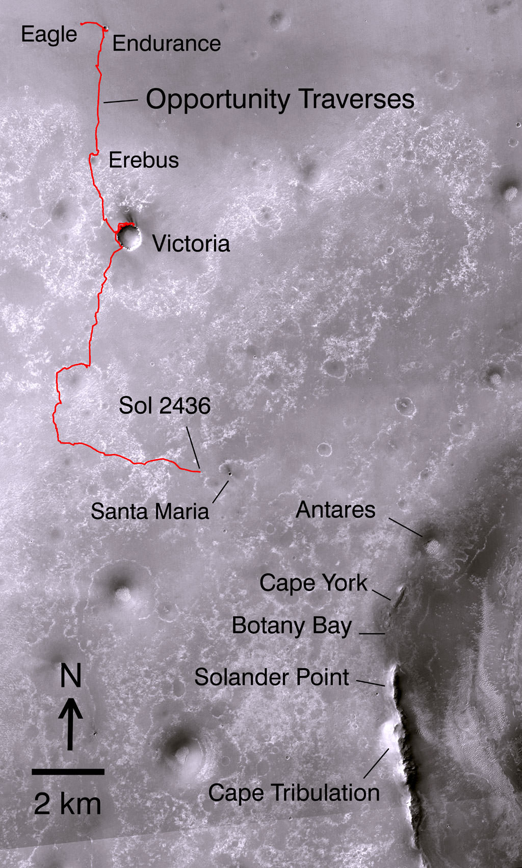
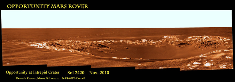
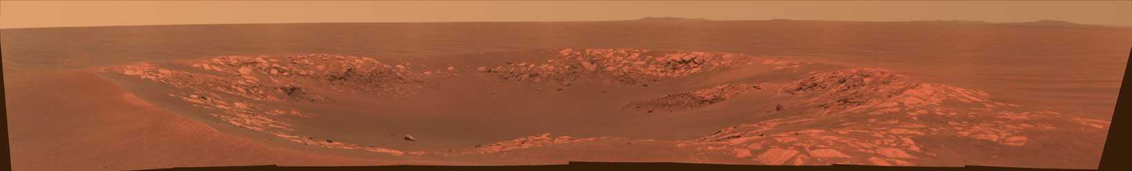
Opportunity made landfall at the western edge of Santa Maria on Dec. 15 (Sol 2450) after a long and arduous journey of some 19 km since departing from Victoria Crater over 2 years ago in September 2008. She crawled closer to the rim the next day on Dec. 16 (Sol 2451) unveiling a magnificent vista of jumbled ejecta rocks, steep sloped cliffs and undulating sand dunes across the crater floor.

“Santa Maria is a relatively fresh impact crater. It’s geologically very young, hardly eroded at all, and hard to date quantitatively. On the order of 10 million years old or less,” said Ray Arvidson in an interview from Washington University in St. Louis. Arvidson is the deputy principal investigator for the Spirit and Opportunity rovers.

Santa Maria from Palos Promontory on Mars.
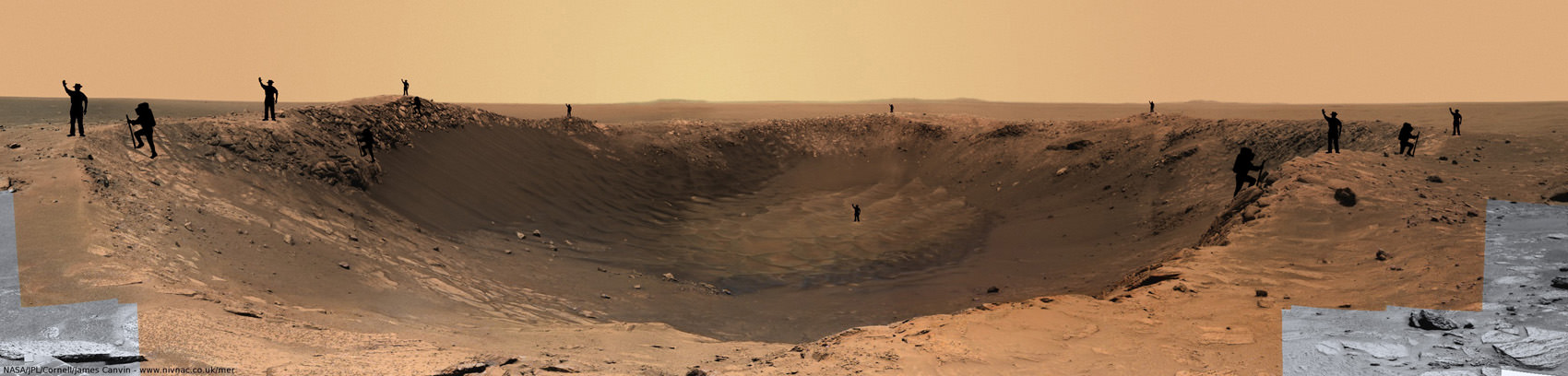
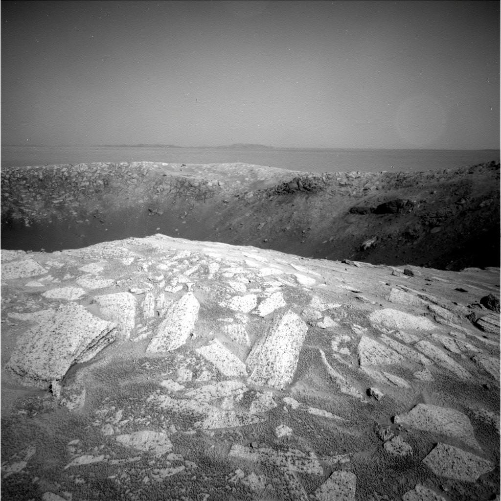
Imagine yourself at the steep cliff walls of Santa Maria crater at a place called Palos. To get a sense of scale in 2 D, human sized figures (2 m tall) have been strategically placed at multiple locations near and far, around and inside this gorgeous panoramic vista. Opportunity drove closer and snapped these images just 2.5 meters from the crater’s edge on Sols 2453 & 2454. Mosaic Credit: NASA/JPL/Cornell, James Canvin. Annotations of Mysterious men in black hats and their cousins, the French climbers by FredK and ElkDanGrove at unmannedspaceflight.com

“Santa Maria is the freshest big guy that Opportunity has seen and has a raised rim,” Arvidson told me. “It is much younger than Endurance Crater which Opportunity visited a few months after landing on Mars way back in 2004 and is roughly the same diameter.” See the entire Opportunity traverse map below.

“The crater is young enough that the interesting hydrate outcrops may not be coated with the nanophase iron oxide dust. There is virtually no erosion. We can see the ejecta rays and blocks,“ said Arvidson.

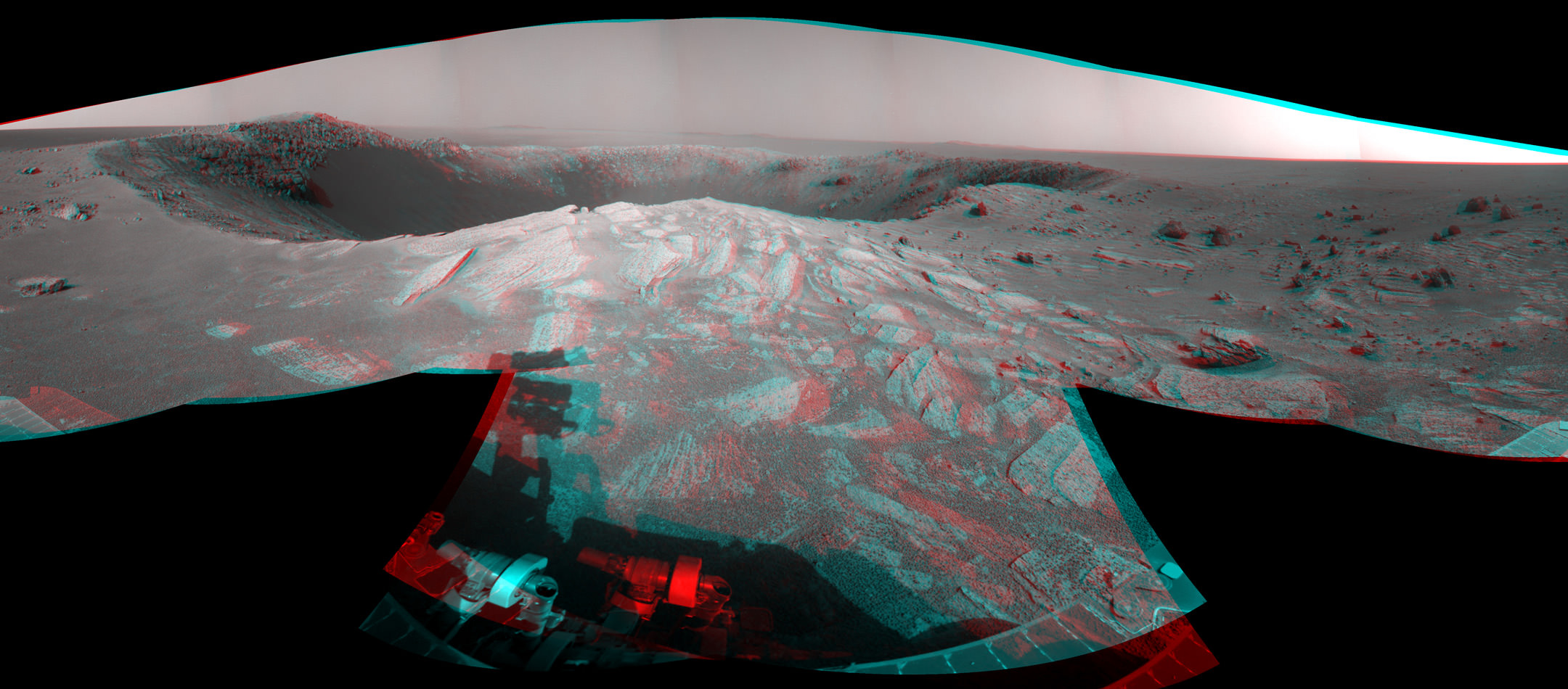
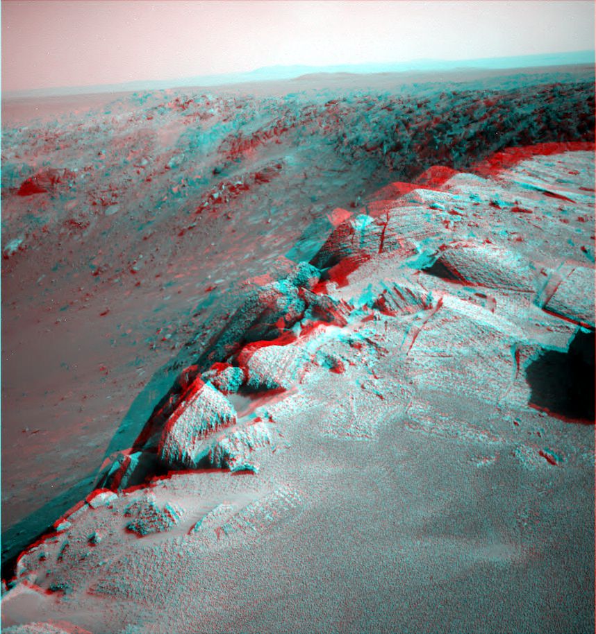
While sitting just five meters from the rim on Dec. 16, Opportunity imaged the football field sized crater – some 90 m wide – with both its left and right eye navigation cameras. A mosaic of these images was stitched together by NASA to create a stunning 360 degree stereo panoramic vista. The images are snapped from the same height seen by an adult to give the perspective that a human eye would see when standing “On Mars”.

The crater is the centerpiece of the stereo image above, which shows the crater’s sharp rim and rocks ejected from the impact that had excavated the crater. You will need to whip out your red-cyan stereo glasses to experience the full three-dimensional effect of the scene. Be sure to wear the red lens on the left, and try not to fall off the cliff.

Click here for the entire 360-degree high resolution stereo view – its 10 MB in all. South is at the center. North is at both ends. The view is presented as a cylindrical-perspective projection. The wheel tracks left behind in the Martian dirt – as the rover approached the crater – are seen at the far right and are also highlighted in our 2 D mosaic below.

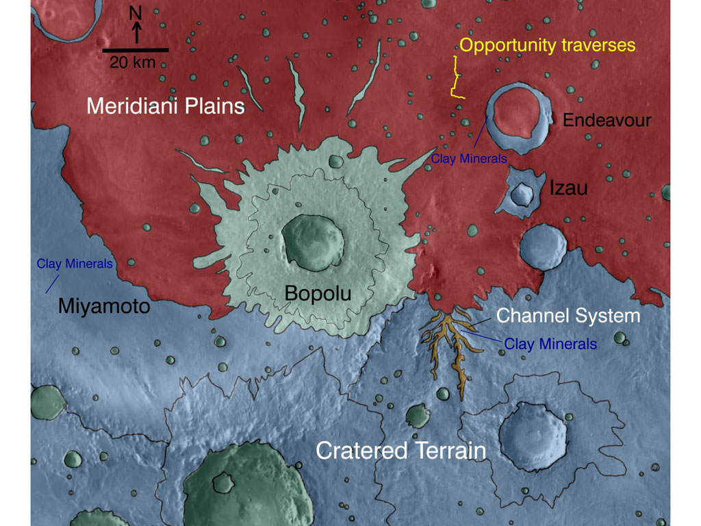
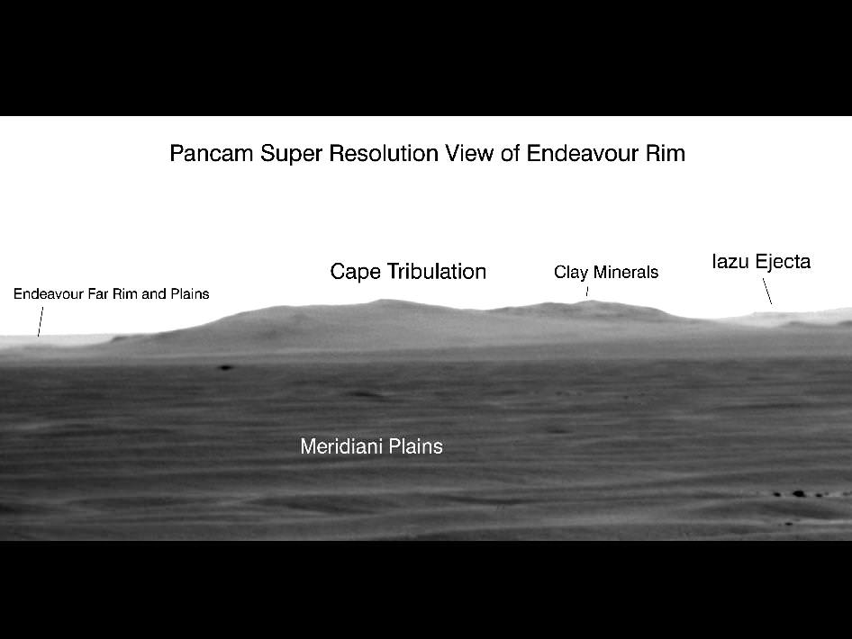
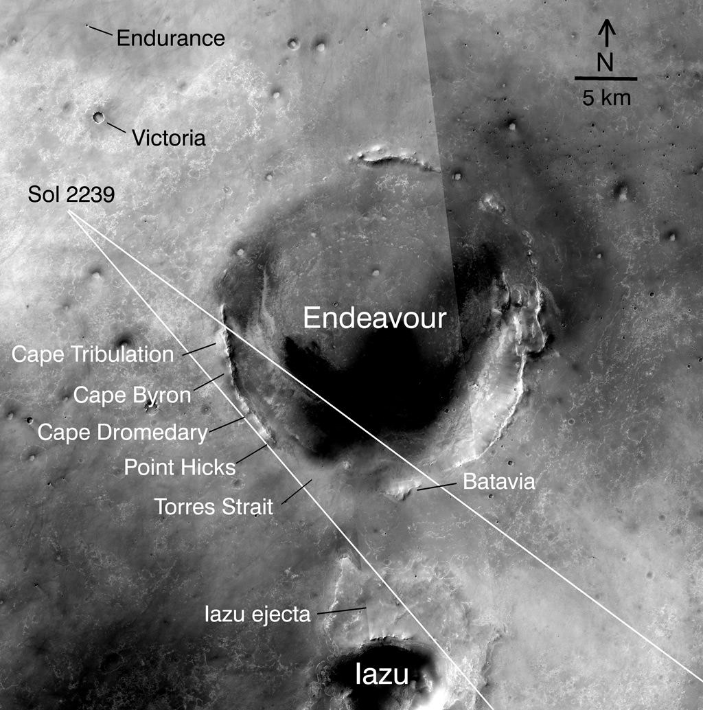
Off in the distance, several portions of the rim of Endeavour Crater are visible as bumps on the horizon. Endeavour is the ultimate target of Opportunity’s long term trek across the Martian dunes at the Meridiani Planum region and is some 22 kilometers in diameter.

“Endeavour shows significant signatures of phylloslicates, or clay minerals, and water bearing sulfate minerals which formed in the presence of liquid water,” Arvidson explained. “The phyllosilicates formed at the crater rim about 3.8 to 4.2 Billion years ago and predate the sedimentary rocks which are younger than 3.8 billion years.”

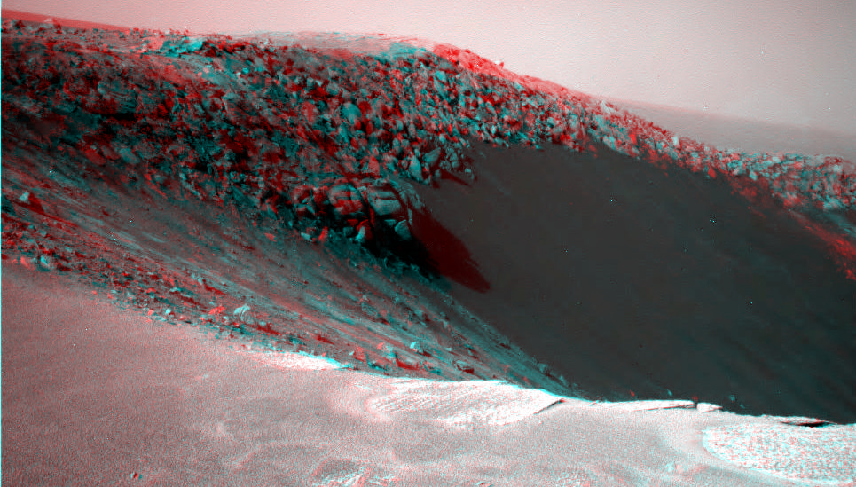
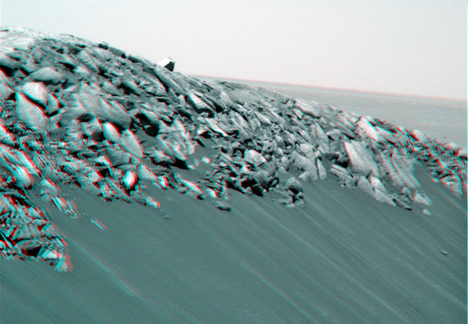
Pictured below is a collection of stereo photo mosaics for a North to South up close tour around the rim of Santa Maria. Several of the images were created by members of unmannedspaceflight.com.

“Opportunity will drive in a counterclockwise direction around Santa Maria to reach the very interesting hydrated sulfates on the other side. We’ll make 3 stops or more depending on what we see”

Stereo view of the sharp northern rim of Santa Maria on Sol 2451. Credit: NASA/JPL/Cornell/Stu Atkinson
Convoluted martian rocks in 3 D close up at the sharp northern rim of Santa Maria. Credit: NASA/JPL/Cornell/Walfy at unmannedspaceflight.com

“On Dec. 19 (Sol 2454) we bumped the vehicle even closer to the rim from the initial approach point, to a promontory we’ve nicknamed ‘Palos’, stated Arvidson. “Opportunity was a mere 2.5 meters from the edge. At ‘Palos’, the rover collected the first set of long baseline, high resolution stereo images for creating a 3 D digital elevation map.”

“The coves at Santa Maria will be named after the islands which Columbus visited, using the native American language. All the rocks and boulders strewn about will be named after the sailors on the voyage with Columbus,” explained Arvidson.

“This past weekend we drove about 20 meters southeast towards the second location named ‘Wanahani’. On Tuesday of this week (Dec. 28) we bumped to the edge. The plan is to photograph the ejecta rocks and collect the next set of long baseline, high resolution stereo images.”

The third stop – which must be reached before Solar Conjunction in mid January 2011- will take Opportunity to the science hot spot detected by the powerful CRISM mineral mapping spectrometer circling above Mars aboard NASA’s Mars Reconnaissance Orbiter (MRO).

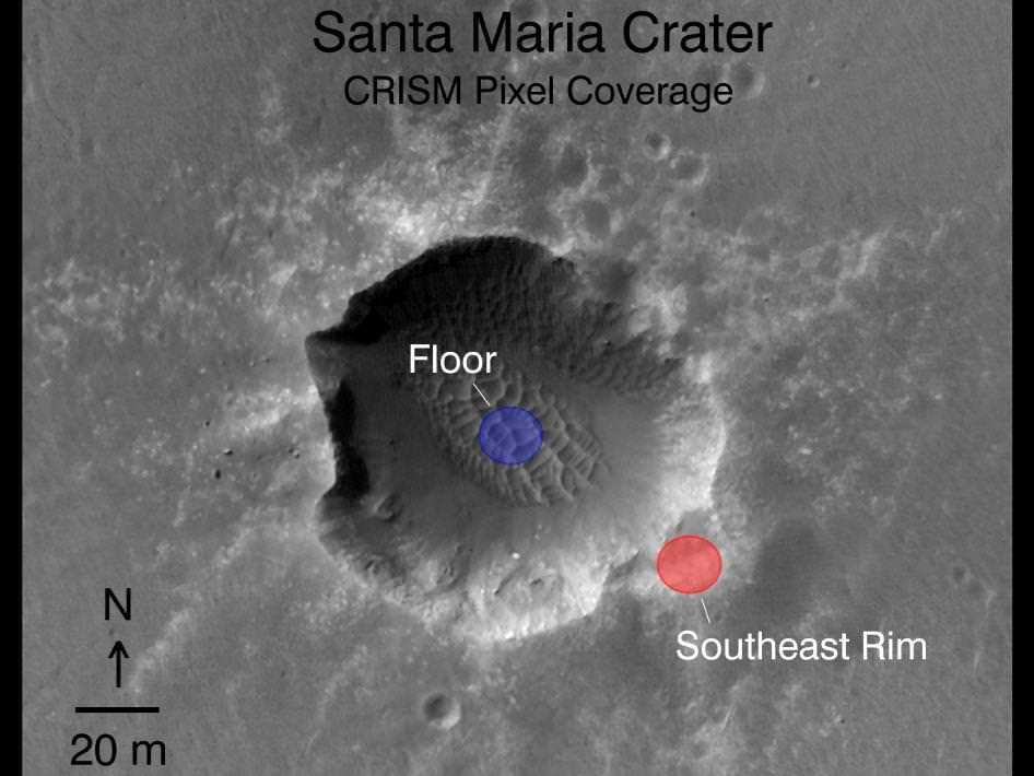
“With CRISM we are trying to cover all the rim segments to better understand the nature and geologic setting of the iron and magnesium smectite clay mineral exposures. The southeast portion of Santa Maria is generally the location of the CRISM spectra that show hydrated sulfates. Opportunity will go to the southeast rim and try and find a nice outcrop on the rim side to do measurements to field verify the expected mineralogy,” explained Arvidson.

“We might do a toe dip with the wheels but there is no plan to go inside.”

“We will use the Rock Abrasion Tool (RAT) to drill into a selected target. That spot will be named after ‘Columbus’.

The exposures of hydrated sulfates have a bright toned appearence in the images.

“With the sun over the camera’s shoulder there is a phenomenon called opposition effect in which rocks and soils become particularly bright when the sun-camera-surface line up, Arvidson told me. “But, it also may be that the bright looking rocks are intrinsically bright and not coated with the nanophase iron oxide coatings we have seen on previous outcrops. All in the realm of testable working hypotheses.”

“On Dec. 30 we are planning another CRISM spectral mapping campaign with MRO over Santa Maria,” said Arvidson. “Using a new technique which gimbals, or swivels, the CRISM optics we hope to use a pixel overlap technique to improve the ground resolution from 18 meters across to 6 meters across. This data will be used in tactical decisions about where to drive on Mars.”

Read more of my interview with Ray Arvidson in the next feature story describing the exciting plan for science exploration at Santa Maria and Endeavour, the outlook for Spirit and more – along with new mosaics from “Wanahani”.

Hydrated Sulfates in 3 D at Santa Maria.
This cropped 3 D segment shows the location of the bright toned exposures of hydrated sulfate minerals detected inside the southeast rim of the steep walled crater. Deposits of hydrated sulfates are an indicator of the past flow of liquid water on Mars. They were detected from orbit by the CRISM mapping spectrometer aboard NASA’s Mars Reconnaissance Orbiter (MRO). Opportunity will go to the SE rim and try to do measurements to field verify the expected mineralogy. Credit: NASA/JPL/Cornell
Looking in stereo to the steep walled southern rim of Santa Maria.
Opportunity will drive to the south rim in January 2011. Cape Tribulation is in the background and located at the western rim of the huge Endeavour Crater which possesses deposits of clay minerals, or phyllosilicates, which form in the presence of neutral liquid water. Cape Tribulation is about 100 meters tall. Credit: NASA/JPL/Cornell/NickF at unmannedspaceflight.com
‘Crocodile Tail’ in 3D.
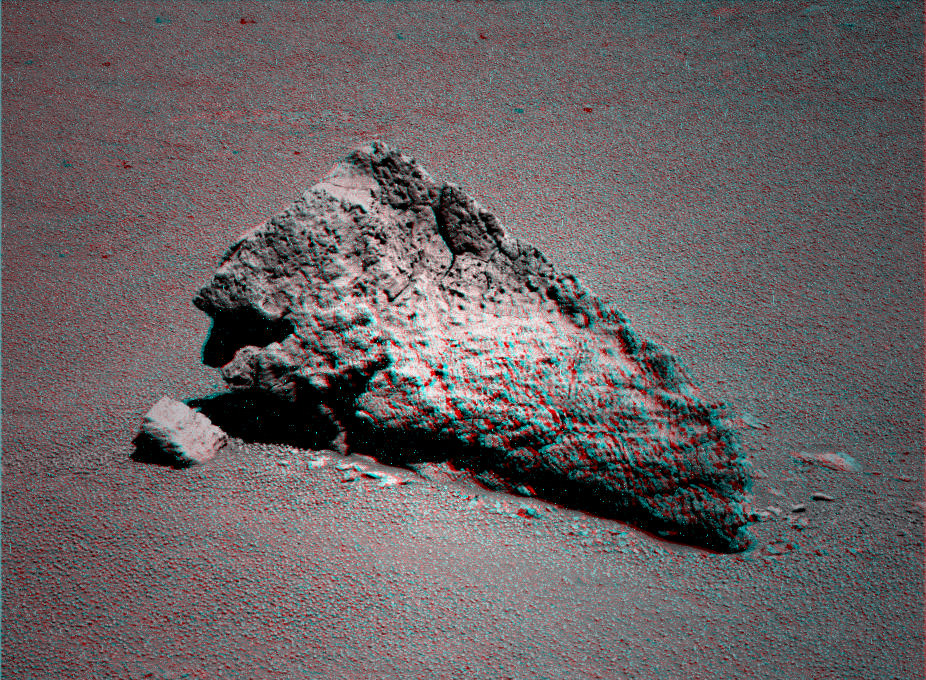
Opportiunity drove past this amazing looking ejecta rock at the outskirts of Santa Maria Crater while approaching the rim. Credit: NASA/JPL/Cornell/Stu Atkinson
Rover wheel tracks on Mars
This mosaic of images from Sol 2451 (Not in 3 D) shows the tracks from Opportunity’s wheels on the approach to the steep crater rim on Sol 2450. Credit: NASA/JPL/Cornell, Marco Di Lorenzo, Ken Kremer
The Long Journey to Santa Maria:
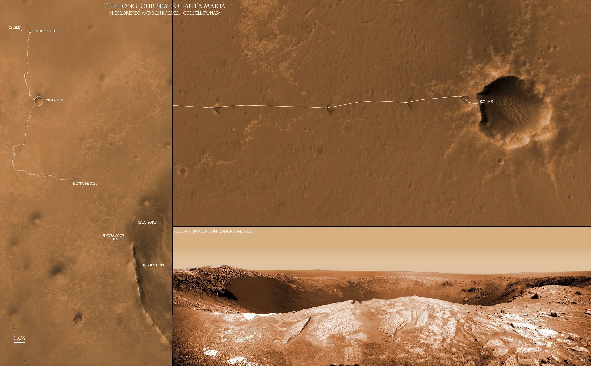
This collage of two maps and a 2 D close up panorama of Santa Maria crater (bottom right) shows the route traversed by the Opportunity Mars rover during her nearly 7 year long overland expedition across the Meridiani Planum region of Mars. Opportunity arrived at the rim of Santa Maria Crater on Dec. 16, 2010 on Sol 2451 and will drive around the edge in a counterclockwise direction to examine rocks which are indicative of the past flow of liquid water. The next destination is Endeavour Crater - some 22 km wide - to investigate water bearing minerals at Cape York and Cape Tribulation which she will reach sometime in 2011. Credit: NASA/JPL/Cornell, Marco Di Lorenzo, Ken Kremer

Powerful Mars Orbiter Directs Opportunity to Clays and Hydrated Minerals

This map indicates geological units in the region of Mars around a smaller area where Opportunity has driven from early 2004 through late 2010. The blue-coded unit encompassing most of the southern half of the mapped region is ancient cratered terrain. In the northern region, it is overlain by younger sediments of the Meridiani Plains, punctuated by the even younger Bopulu impact. At Endeavour Crater, in the upper right near the gold line of Opportunity's traverse, ancient cratered terrain is exposed around the crater rim. Locations where orbital observations have detected clay minerals are indicated at the western edge of Endeavour and at two locations in the southern portion of the map. The mineral mapping was done by Sandra Wiseman and Ray Arvidson of Washington Universty in St. Louis based on observations by the Compact Reconnaissance Imaging Spectrometer for Mars (CRISM) on NASA's Mars Reconnaissance Orbiter.

[/caption]

NASA is using its powerful science surveyor orbiting more than 241 kilometers above Mars to target the surface explorations of the long lived Opportunity rover to compelling science targets on the ground. Opportunity is currently on a long term trek to the giant crater named Endeavour, some 22 kilometers in diameter, which shows significant signatures of clays and water bearing sulfate minerals which formed in the presence of flowing liquid water billions of years ago.

An armada of orbiters and rovers from Earth are carrying out a coordinated attack plan to unlock the mysteries of the red planet, foremost being to determine whether life ever arose on Mars.

On Dec. 15 (Sol 2450), Opportunity arrived at Santa Maria crater which is just 6 km distant from the western rim of Endeavour. Over the past 2 years, the rover has traversed more than two thirds of the 19 km distance from Victoria crater -her last big target – to Endeavour.

High resolution spectral and imaging mappers aboard NASA’s Mars Reconnaissance Orbiter (MRO) are enabling researchers on the rover team to prioritize targets and strategically guide Opportunity to the most fruitful locations for scientific investigations.

The on board CRISM mapping spectrometer has detected clay minerals, or phyllosilicates, at multiple locations around Endeavour crater including the western rim closest to Opportunity. CRISM is the acronym for Compact Reconnaissance Imaging Spectrometer for Mars. Images from MRO’s HiRISE camera are utilized to scout out the safest and most efficient route. See maps above and below.

“This is the first time mineral detections from orbit are being used in tactical decisions about where to drive on Mars,” said Ray Arvidson of Washington University in St. Louis. Arvidson is the deputy principal investigator for the Spirit and Opportunity rovers and a co-investigator for CRISM.

Clay minerals are a very exciting scientific find because they can form in more neutral and much less acidic aqueous environments which are more conducive to the possibility for the formation of life. They have never before been studied up close by science instruments on a landed mission.

Opportunity may soon get a quick taste of water bearing sulfate minerals at Santa Maria because spectral data from CRISM suggest the presence of sulfate deposits at the southeast rim of the crater. Opportunity has previously investigated these sulfate minerals at other locations along her circuitous traverse route – but which she discovered without the help of orbital assets.

“We’ve just pulled up to the rim of Santa Maria, and the workload is very high,” Steve Squyres informed me. Squyres, of Cornell University, is the Principal Scientific Investigator for NASA’s Spirit and Opportunity Mars rovers.

Opportunity drove to within about 5 meters of the crater rim on Dec. 16 (Sol 2451). JPL Mars rover driver Scott Maxwell tweeted this message ; “Today’s NAVCAM mosaic of Santa Maria Crater. Woo-hoo! Glorious and beautiful!” and this twitpic

Orbital Observations at Santa Maria Crater.
Opportunity just arrived at the western side of Santa Maria Crater, some 90 meters wide, on 15 December 2010. Researchers are using data collected by a powerful mineral mapping spectrometer (CRISM) aboard NASA’s Mars Reconnaissance Orbiter (MRO) to direct the route which Opportunity is traversing on Mars during the long term journey to Endeavour crater. Spectral observations recorded by CRISM indicates the presence of water-bearing sulfate minerals at the location shown by the red dot on the southeast rim crater whereas the crater floor at the blue dot does not. This image was taken by the the High Resolution Imaging Science Experiment (HiRISE) camera also on MRO. Credit: NASA/JPL-Caltech/Univ. of Arizona

The rover will conduct an extensive science campaign at Santa Maria by driving to different spots over the next several weeks and gathering data to compare observations on the ground to those from CRISM in orbit.

Opportunity Navcam camera view of Santa Maria Crater just 5 m from the rim on Sol 2451, Dec. 16, 2010. Click to enlarge

Santa Maria crater appears to be relatively fresh and steep walled and was likely created by a meteor strike only a few million years ago. Endeavour is an ancient crater with a discontinuous rim that is heavily eroded at many points. By exploring craters, scientists can look back in time and decipher earlier geologic periods in Mars history.

Scientists believe that the clay minerals stem from an earlier time period in Martian history and that the sulfate deposits formed later. Mars has experiences many episodes of wet environments at diverse locations in the past and climate-change cycles persist into the present era.

After the upcoming Solar Conjunction in February 2011, Opportunity will depart eastwards for the last leg of the long march to Endeavour. She heads for a rim fragment dubbed Cape York which spectral data show is surrounded by exposures of water bearing minerals. Cape York is not yet visible in the long distance images because it lies to low. See maps below.

Thereafter, Opportunity alters direction and turns south towards her next goal –
Cape Tribulation – which is even more enticing to researchers because CRISM has detected exposures of the clay minerals formed in the milder environments more favorable to life. Cape Tribulation has been clearly visible in rover images already taken months ago in early 2010.

Opportunity could reach Endeavour sometime in 2011 if she can continue to survive the harsh environment of Mars and drive at her current accelerated pace. Opportunity arrived at Mars in January 2004 for a planned 90 day mission. The rover has far surpassed all expectations and will soon celebrate 7 earth years of continuous operations on the red planet. Virtually all the data from Spirit and Opportunity are relayed back to Earth via NASA’s Mars Odyssey orbiter.


Opportunity used its panoramic camera in a super-resolution technique to record this view of the horizon on Sol 2298 (July 11, 2010) which shows the western rim of Endeavour Crater, including the highest ridge informally named “Cape Tribulation”. CRISM data revealed exposures of clay minerals at Cape Tribulation.

Opportunity’s Path on Mars Through Sol 2436
The red line shows where Opportunity has driven from the place where it landed in January 2004 — inside Eagle Crater, at the upper left end of the track — to where it reached on the 2,436th Martian day, or sol, of its work on Mars (Nov. 30, 2010). The map covers an area about 15 kilometers (9 miles) wide. North is at the top. Subsequent drives brought Opportunity to Santa Maria Crater, which is about 90 meters (295 feet) in diameter. After investigating Santa Maria the rover heads for Endeavour Crater. The western edge of 22-kilometer-wide (14-mile-wide) Endeavour is in the lower right corner of this map. Some sections of the discontinuous raised rim and nearby features are indicated with informal names on the map: rim segments “Cape York” and “Solander Point”; a low area between them called “Botany Bay”; “Antares” crater, which formed on sedimentary rocks where the rim was eroded down; and rim fragment “Cape Tribulation,” where orbital observations have detected clay minerals. The base map is a mosaic of images from the Context Camera on NASA’s Mars Reconnaissance Orbiter.

Did Iapetus Have Its Own Mini Moon?

A ridge that follows the equator of Saturn's moon Iapetus gives it the appearance of a giant walnut. This image was taken by the Cassini spacecraft. Credit: NASA/JPL/SSI

[/caption]

There’s a new theory for why Saturn’s moon Iapetus looks like a walnut. The moon has a mysterious large ridge that covers more than 75 percent of the moon’s equator. Figuring out the reason for the ridge, say researchers from Washington University in St. Louis, has been a tough nut to crack. But they propose that at one time Iapetus itself had its very own moon, and the orbit of this mini-moon-around-another-moon would have decayed because of tidal interactions with Iapetus, and those forces would have torn the sub-satellite apart, forming a ring of debris around Iapetus that would eventually slam into the moon near its equator.

This is not the nuttiest proposal ever…

A closeup of Iapetus' ridge. In 2007, Cassini flew within a few thousand kilometers of Iapetus' surface to take this dramatic image. Credit: NASA/JPL/SSI

The ridge on Iapetus is 100 kilometers (62 miles) wide and at place, 20 kilometers (12 miles) high. (The peak of Mount Everest, by comparison, is 8.8 km (5.5 miles) above sea level.) Iapetus itself is 1,470 km across, and is the 11th largest moon in the Solar System.

Professor William McKinnon and his former doctoral student, Andrew Dombard — now from the University of Illinois Chicago — came up with this idea.

“Imagine all of these particles coming down horizontally across the equatorial surface at about 400 meters per second, the speed of a rifle bullet, one after the other, like frozen baseballs,” said McKinnon. “Particles would impact one by one, over and over again on the equatorial line. At first the debris would have made holes to form a groove that eventually filled up.”

“When you have a debris ring around a body, the collisional interactions steal energy out of the orbit,” Dombard said. “And the lowest energy state that a body can be in is right over the rotational bulge of a planetary body — the equator. That’s why the rings of Jupiter, Saturn, Uranus and Neptune are over the equator.”

“We have a lot of corroborating calculations that demonstrate that this is a plausible idea,” added Dombard, “but we don’t yet have any rigorous simulations to show the process in action. Hopefully, that’s next.”

Other ideas for how the ridge was created are volcanism or mountain-building forces.

“Some people have proposed that the ridge might have been caused by a string of volcanic eruptions, or maybe it’s a set of faults,” said McKinnon. “But to align it all perfectly like that — there is just no similar example in the solar system to point to such a thing.”

Dombard said there are three critical observations that any model for the formation of the ridge has to satisfy: Why the feature is sitting on the equator; why only on the equator, and why only on Iapetus.
Dombard says that Iapetus’s Hill sphere — the zone close to an astronomical body where the body’s gravity dominates satellites — is far bigger than that of any other major satellite in the outer solar system, accounting for why Iapetus is the only body known to have such a ridge.

“Only Iapetus could have had the orbital space for the sub-satellite to then evolve and come down toward its surface and break up and supply the ridge,” he says.

Dombard will make a presentation on the preliminary findings Wed., Dec. 15, 2010, at the fall meeting of the American Geophysical Union in San Francisco. The team also included Andrew F. Cheng of the Johns Hopkins Applied Physics Laboratory, and Jonathan P. Kay, a graduate student at UIC.

Source: Wash U

Asteroid Scheila Sprouts a Tail and Coma

(596) Scheila, the asteroid with a tail. Image credit: Peter Lake

[/caption]
When is an asteroid not an asteroid? When it turns out to be a comet, of course. Has this ever happened before? Why, yes it has. In fact it was just announced December 12, 2010 that the asteroid (596) Scheila has sprouted a tail and coma! This is likely a comet that has been masquerading as an asteroid.

Taken from New Mexico Skies between 8h15m and 11h45m UT. The image is a stack of 10 x 600 sec exposures using a 20 inch RCOS and STL11K camera. Scale is 0.91 asec/px.. Image courtesy of Joseph Brimacombe

See an animation by Joseph Brimacombe at this link.

Steve Larson of the Lunar and Planetary Laboratory (LPL), University of Arizona first reported that images of the minor planet (596) Scheila taken on December 11th showed the object to be in outburst, with a comet-like appearance and an increase in brightness from magnitude 14.5 to 13.4. The cometary appearance of the object was confirmed by several other observers within hours.

A quick check of archived Catalina images of Scheila from October 18, November 2 and November 11 showed Scheila to look star-like, which is what asteroids look like from Earth. They just happen to be moving across the field of view in contrast to the fixed background stars. The image taken by Catalina on December 3rd shows some slight diffuseness and an increase in overall brightness. So, it appears this event began on or around December 3rd.

Upon hearing the news, there was some speculation that this might be evidence of an impact event. Had something crashed into asteroid Scheila? It seems unlikely, and this is a story we have heard before.

The asteroid discovered in 1979 and named 1979 OW7 was lost to astronomers for years and then recovered in 1996. It was subsequently renamed 1996 N2. That same year it was discovered to have a comet-like appearance, and many believed this was the signature of an impact between two asteroids. After years of inactivity 1996 N2 sprouted a tail again in 2002. One collision between two asteroids was unlikely enough. The odds of it happening again to the same object were essentially zero. What we had was a comet masquerading as an asteroid. This object is now known by its cometary name 133P/Elst-Pizarro, named after the two astronomers who discovered its initial cometary outburst.

The 2002 outburst and the discovery of more active asteroids showing mass-loss led to a paper (Hsieh and Jewitt 2006, Science, 312, 561-563) introducing an entirely new class of solar system objects, Main Belt Comets (MBC). MBCs look like comets because they show comae and have tails but they have orbits inside Jupiter’s orbit like main belt asteroids.

The most likely cause of the mass loss activity in MBCs is sublimation of water ice as the surface of the MBC is heated by the Sun. This is suggested most strongly by the behavior of the best-studied example, namely 133P/Elst-Pizarro. Its activity is recurrent, and it is strongest near and after perihelion, the point in its orbit nearest the Sun, like other comets.

MBCs are interesting to astronomers because they appear to be a third reservoir of comets in our solar system, distinct from the Oort cloud and Kuiper belt. Since we know of no way for these other reservoirs to have deposited comets in the inner solar system, the ice in MBCs probably has a different history than the ice in the outer comets. This allows researchers to study the differences in the Sun’s proto-planetary disk at three separate locations. This might lead to information on the Earth’s oceans, one of the continuing lines of investigation by solar system scientists.

Now it seems we have another MBC to add to the sample. And Scheila will probably be getting a new name soon. Asteroid (596) Scheila was discovered Feb. 21, 1906, by A. Kopff at Heidelberg. The 113Km in diameter ‘asteroid’ was named after an acquaintance, an English student at Heidelberg. In the future it will be called XXXP/Lawson or something similar, and Kopff’s Scheila will become just another footnote in the history of astronomical nomenclature.

How Are You Celebrating the Year of the Solar System?

There are a lot of solar system space missions coming up, plus – as always – a plethora of astronomical events taking place, so NASA has decided to declare the “Year of the Solar System” (YSS). But this year is so big, it won’t fit into an Earth year — however, a Martian year just about covers it, so from now until August, 2012 we’re celebrating.

“During YSS, we’ll see triple the usual number of launches, flybys and orbital insertions,” said Jim Green, the director of Planetary Science at NASA headquarters. “There hasn’t been anything quite like it in the history of the Space Age. History will remember the period Oct. 2010 through Aug. 2012 as a golden age of planetary exploration.”

Below you’ll see a list of mission activities that will take place, but also, the YSS organizers will have special events – both online and at various venues – to help us all celebrate.

One project near and dear to my heart is the 365 Days of Astronomy podcast, which will be continuing at least through 2011. Universe Today readers, you’d help me out A LOT (I’m the 365 Days project manager) by signing up to do a podcast. Podcasting is an easy and wonderful way to share your knowledge, experiences and love of astronomy or space. We give you lots of info about what you need to do to created a podcast. Check out the website, the calendar for available dates in 2011, and you can contact me directly to sign up for a date!

For other things associated with the YSS, there are also activities and materials available for classrooms and teachers, afterschool programs, astronomy clubs and more.

Right now, during December and January, the activities focus on investigations of our planetary family tree. Conduct the Explore the Celestial Neighborhood … in Your Neighborhood! activity and others fun projects that examine what a planet is and how we investigate planets.

There is also information on how to observe the total lunar eclipse on December 21, or activities to simply note the change in lunar phases over the course of a month.

You can also submit photographs, artwork, music, or words of your YSS experiences at the Share Your Stories page.

This artist's illustration shows how the Sun would have looked from Carl Sagan Memorial Station at a specific time each month on Mars over the course of a Martian year. (Credit: Dennis Mammana)

As far as the solar system missions going on we’ve already enjoyed the flyby of Comet Hartley 2 by the Deep impact/EPOXI spacecraft, and the NASA O/OREOS (“Organism/ORganic Exposure to Orbital Stresses,”) spacecraft was launched in November 2010, to study “the durability of life in space.” It is a nanosatellite (a cubesat), only 5.5 kilograms in mass, and we’ll certainly be hearing more about that spacecraft soon.

NASA NanoSail-D was also launched by the same rocket, and it has been ejected from the spacecraft but hasn’t yet unfurled its sails. We’ll post something as soon as any news on that emerges.
Here are more upcoming mission highlights as part of the YSS:

Stardust NExT encounters comet Tempel on February 14.

MESSENGER enters an orbit around the planet Mercury on March 18.

Dawn begins its approach to the asteroid Vesta in May, for a mission between 2011 and 2012. It will also visit the dwarf planet Ceres in 2015.

The Juno spacecraft will launch to Jupiter in August 2011. It will study the planet’s composition, gravity field, magnetic field, and polar magnetosphere.

GRAIL, or the NASA Gravity Recovery and Interior Laboratory (GRAIL) spacecraft will launch for a mapping mission to the Moon in September 2011.

Curiosity, or the Mars Science Lab will launch in November 2011. This is a big, car-sized rover that will look for potential habitable places, and more, on Mars. Curiosity is slated to land in August, 2012.

Apollo 12 anniversary celebrated at Martian Crater as Opportunity blazes ahead

Opportunity arrived at ‘Intrepid’ Crater on Mars during November 2010 and drove around crater rim. See rover wheel tracks at left. Intrepid crater was named in honor of the Apollo 12 lunar module named “Intrepid” – which landed two men on the moon on 19 November 1969. This false color mosaic was assembled from pancam images taken by Opportunity on Sol 2420 (Nov 14, 2010). Mosaic Credit: Kenneth Kremer, Marco Di Lorenzo NASA/JPL/Cornell

[/caption]

NASA recently celebrated the anniversary of the historic Apollo 12 lunar landing mission with another history making craft – the long lived Opportunity Mars rover. Opportunity traversed around and photographed ‘Intrepid’ crater on Mars in mid November 2010. The crater is informally named in honor of the ‘Intrepid’ lunar module which landed two humans on the surface of the moon on 19 November 1969, some forty one years ago.

Apollo 12 was only the second of NASA’s Apollo missions to place humans on the Earth’s moon. Apollo astronauts Pete Conrad and Gordon Bean precisely piloted their lunar landing spacecraft nicknamed ‘Intrepid’ to a safe touchdown in the ‘Ocean of Storms’, a mere 180 meters (600 feet) away from the Surveyor 3 robotic lunar probe which had already landed on the moon in April 1967. The unmanned Surveyor landers paved the way for NASA’s manned Apollo landers.

As Conrad and Bean walked on the moon and collected lunar rocks for science, the third member of the Apollo 12 crew, astronaut Dick Gordon, orbited alone in the ‘Yankee Clipper’ command module and collected valuable science data from overhead.

On the anniversary of the lunar landing, the rover science team decided to honor the Apollo 12 mission as Opportunity was driving east and chanced upon a field of small impact craters located in between vast Martian dune fields. Informal crater names are assigned by the team to craters spotted by Opportunity in the Meridiani Planum region based on the names of historic ships of exploration.

Opportunity rover took first panorama of Intrepid crater on Sol 2417 (Nov.11, 2010) which shows the rim of distant Endeavour crater in the background. Mosaic Credit: NASA/JPL/Cornell

Rover science team member James Rice, of NASA’s Goddard Space Flight Center, Greenbelt, Md., suggested using names from Apollo 12 because of the coincidental timing according to NASA. “The Apollo missions were so inspiring when I was young, I remember all the dates. When we were approaching these craters, I realized we were getting close to the Nov. 19 anniversary for Apollo 12,” Rice said. He sent Bean and Gordon photographs that Opportunity took of the two craters named for the two Apollo 12 spaceships.

Bean wrote back the following message to the Mars Exploration Rover team: “I just talked with Dick Gordon about the wonderful honor you have bestowed upon our Apollo 12 spacecraft. Forty-one years ago today, we were approaching the moon in Yankee Clipper with Intrepid in tow. We were excited to have the opportunity to perform some important exploration of a place in the universe other than planet Earth where humans had not gone before. We were anxious to give it our best effort. You and your team have that same opportunity. Give it your best effort.”

On November 4, Opportunity drove by and imaged ‘Yankee Clipper’ crater. After driving several more days she reached ‘Intrepid’ on November 9. The rover then traversed around the crater rim and photographed the crater interior from different vantage points, collecting two panoramic views along the way.

The rover team assembled the initial tribute panoramic mosaic taken on Sol 2417 (Nov. 11) and which can be seen here in high resolution along with ‘Yankee Clipper’.

Opportunity soon departed Intrepid on Sol 2420 (Nov. 14) to resume her multi-year trek eastwards and took a series of crater images that day – from a very different direction – which we were inspired to assemble into a panoramic mosaic (in false color) in tribute to the Apollo 12 mission (see above).

Our mosaic tribute clearly shows the rover wheel tracks as Opportunity first approached Intrepid on Nov. 9 – which is fittingly reminiscent of the Apollo 12 astronauts walking on the moon 41 years ago as they explored a lunar crater. By comparison, the arrival mosaic from Sol 2417 shows distant Endeavour crater in the background.

Intrepid crater is about 16 meters in diameter, thus similar in size to ‘Eagle’ crater inside which Opportunity first landed on 24 January 2004 after a 250 million mile ‘hole in one shot’ from Earth. Eagle was named in honor of the Apollo 11 mission.

“Intrepid is fairly eroded with sand filling the interior and ejecta blocks planed off by the saltating sand”, said Matt Golembek, Mars Exploration Program Landing Site Scientist at the Jet Propulsion Laboratory (JPL), Pasadena, Calif. Asked about the age of Intrepid crater, Golembek told me; “Based on the erosional state it is at least several million years old, but less than around 20 million years old.”

Opportunity is blazing ahead towards a huge 22 km (14 mile) wide crater named ‘Endeavour’, which shows distinct signatures of clays and past wet environments based on orbital imagery thus making the crater a compelling science target.

“Intrepid is 1.5 km from Santa Maria crater and about 7.5 km from Endeavour.”

“We should be at Santa Maria crater next week, where we will spend the holidays and conjunction. Then it will be 6 km to Endeavour,” Golembek said.

The road ahead looks to be alot friendlier to the intrepid rover. “The terrain Opportunity is on is among the smoothest and easiest to traverse since Eagle and Endurance. Should be smooth sailing to Endeavour, averaging about 100 meters per drive sol. We should easily beat MSL to the phyllosilicates,” Golembek explained.

Phyllosilicates are clay minerals that form under wet, warm, non-acidic conditions. They have never before been studied on the Martian surface.

MSL is the Mars Science Lab, NASA’s next Mars lander mission and which is scheduled to blast off towards the end of 2011. Golembek leads the landing site selection team.

The amazing Opportunity rover has spent nearly seven years roving the Martian surface, conducting a crater tour during her very unexpectedly long journey at ‘Meridiani Planum’ on Mars which now exceeds 26 km (16 miles). The rovers were designed with a prime mission “warranty” of just 90 Martian days – or sols – and have vastly exceeded their creators expectations.

“What a ride. This still does not seem real,” Rob Manning told me. Manning headed the Entry, Descent and Landing team at JPL for both the Spirit and Opportunity rovers. “That would be fantastic if Opportunity could get to the phyllosilicates before MSL launches.”

Stay tuned.

This map of the region around NASA's Mars Exploration Rover Opportunity shows the relative locations of several craters and the rover location in May 2010. Credit: NASA/JPL-Caltech/Malin Space Science Systems/WUSTL
AS12-48-7133 (20 Nov. 1969) --- This unusual photograph, taken during the second Apollo 12 extravehicular activity (EVA), shows two U.S. spacecraft on the surface of the moon. The Apollo 12 Lunar Module (LM) is in the background. The unmanned Surveyor 3 spacecraft is in the foreground. The Apollo 12 LM, with astronauts Charles Conrad Jr. and Alan L. Bean aboard, landed about 600 feet from Surveyor 3 in the Ocean of Storms. The television camera and several other pieces were taken from Surveyor 3 and brought back to Earth for scientific examination. Here, Conrad examines the Surveyor's TV camera prior to detaching it. Astronaut Richard F. Gordon Jr. remained with the Apollo 12 Command and Service Modules (CSM) in lunar orbit while Conrad and Bean descended in the LM to explore the moon. Surveyor 3 soft-landed on the moon on April 19, 1967.

Venus Has a Moon?

Venusian quasi-satellite 2002 VE68. Illustration: NASA/JPL/Caltech

[/caption]

Astronomers have been busy trying to determine the spin period and composition of Venus’ moon. December 8, 2010, results were announced by JPL/Caltech scientists, led by Michael Hicks.

“Wait a minute; back up”, I hear you ask. “Venus has a Moon?”
Of course it does. Well, kind of…
Let me explain.

It has the rather unfortunate name of 2002 VE68. That is because it was discovered on November 11, 2002 by LONEOS, the Lowell Observatory Near Earth Object Search. 2002 VE68 is an earth orbit-crossing asteroid that has been designated a Potential Hazardous Asteroid by the Minor Planet Center. For obvious reasons, this makes it a very interesting subject of study for JPL scientists.

2002 VE68 used to be a run of the mill, potential impact threat, Near Earth Object. But approximately 7000 years ago it had a close encounter with Earth that kicked it into a new orbit. It now occupies a place in orbit around the Sun where at its closest it wanders inside the orbit of Mercury and at its furthest it reaches just outside the orbit of the Earth. It is now in a 1:1 orbital resonance with Venus.

An orbital resonance is when two orbiting bodies exert a regular, periodic gravitational influence on each other due to their orbital periods being related by a ratio of two small numbers. For example, Pluto and Neptune are in an orbital resonance of 2:3, which simply means for every two times Pluto goes around the Sun, Neptune makes three trips around.

In the case of Venus and 2002 VE68, they both take the same time to orbit the Sun once. They are in a 1:1 orbital resonance. So by definition, 2002 VE68 is considered a quasi-satellite of Venus. If you watch the Orbital Viewer applet at the JPL small body page you can watch this celestial dance as the two bodies orbit the Sun and each other as 2002 VE68 dodges Earth and Mercury in the process.

Often these resonances result in an unstable interaction, in which the bodies exchange momentum and shift orbits until the resonance no longer exists. In this case, scientists believe 2002 VE68 will only remain a Venusian quasi-satellite for another 500 years or so.

So getting back to the story, Hicks and his team used the recent close apparition of 2002 VE68 to do photometric measurements over the course of three nights in November using the JPL Table Mountain 0.6m telescope near Wrightwood, California. From the color data they obtained they determined that 2002 VE68 is an X type asteroid. This is a group of asteroids with very similar spectra that could potentially have a variety of compositions. They are further broken down into Tholen classification types as either E, M or P types. Unfortunately Hicks’ team was not able to resolve the sub-classification with their equipment.

They were able to determine the approximate size of the asteroid to be 200 meters in diameter, based on its absolute magnitude, and they determined a spin rate of 13.5 hours. The amplitude of the fluctuation on the light curve of 2002 VE68 could imply hat it is actually a contact binary, two clumps of asteroidal material orbiting a center of mass in contact with each other.

For more information on some of the strange and curious beasts in the asteroidal zoo, visit the NASA Near Earth Object Program website.

Cassini Instruments Offline Until Nov. 24

Cassini-Huygens Mission
An artist illustration of the Cassini spacecraft. Credit: NASA/JPL

[/caption]

NASA announced that the Cassini spacecraft in orbit around Saturn will have its suite of scientific cameras offline until at least Nov. 24. Cassini is currently in safe mode due to a malfunction in the spacecraft’s computer. This shut down all non-essential systems to prevent any further damage happening to the spacecraft. This means that all scientific efforts on the mission have been suspended until the problem can be resolved.

Although these seem like severe issues, mission managers are relatively sure that they will have no serious long-term effects on the overall mission. Cassini entered safe mode around 4 p.m. PDT (7 p.m. EDT) on Tuesday, Nov. 2. Managers want to review what took place onboard Cassini, correct what they can and ensure that this doesn’t happen again. Programmers have already ascertained that the likely cause of the problem was a faulty program code line that made its way back to Cassini.

Cassini captured this startling image of Saturn's moon Hyperion. Photo Credit: NASA/JPL

Ordinarily when faulty code is sent from Earth to Saturn, Cassini would reject any coding that is deemed ‘bad.’ However, this did not happen in this case, causing the problem. Controllers are not totally convinced that a solar fare didn’t corrupt the code on its way out to the gas giant.

“The spacecraft responded exactly as it should have, and I fully expect that we will get Cassini back up and running with no problems,” said Bob Mitchell, Cassini’s program manager at JPL. “Over the more than six years we have been at Saturn, this is only the second safing event. So considering the complexity of demands we have made on Cassini, the spacecraft has performed exceptionally well for us.”

Cassini launched from Cape Canaveral Air Force Station back in 1997 atop a Titan rocket. In the thirteen years since that time it has entered ‘safe’ mode a total of six times.

Cassini discovered that Saturn's moon Enceladus is 'jet-powered' in the form of geysers erupting from the moon's surface into space. Photo Credit: NASA/JPL

The largest loss for Cassini’s planners is this will cost them a flyby of Titan, one of Saturn’s moons and the only moon in the solar system with an appreciable atmosphere. All is not lost however, as there are still some 53 possible flybys of the moon currently scheduled. The mission is currently planned to last until 2017.

The Cassini-Huygens mission is a cooperative program managed between NASA, the European Space Agency (ESA) and the Italian Space Agency. JPL, a division of the California Institute of Technology (Caltech) manages the Cassini program for NASA’s Science Mission Directorate located in Washington, D.C.

Eyes On The Solar System

Eyes on the Solar System - a 3d environment browser application that operates in real time, letting you see what our robot spacecraft are up to.

[/caption]

NASA’s beta version of Eyes on the Solar System, built by JPL and Caltech, offers a neat way of tracking a range of current space missions – for example, as Nancy Atkinson mentioned yesterday, you can follow EPOXI’s flyby of comet Hartley 2. Reminiscent of Celestia, this browser application gives you a 3D environment running in real time and is updated regularly with NASA spacecraft mission data.

To get it operating, you can just click to the NASA link where you are prompted to install a Unity Web Player plug-in. This is fast and straight forward, from my experience. I did strike a problem with a certain small and squishy 64bit system that starts with X (where the menu text didn’t display correctly), but it ran fine on other systems. It is a beta version after all – and I feel obliged to note you should load at your own risk, yada, yada.

Anyhow, if you choose to proceed, you can then move around the solar system with left mouse click-hold and scroll wheel actions – or there’s the usual keyboard alternatives, or even on-screen controls. In default mode, a number of celestial bodies are shown and labeled, as are several spacecraft, which you can zoom over to by clicking on them. You can add more objects from the Visual Controls menu. Default settings have comets hidden, so you’ll need to add them to do an EPOXI-Hartley 2 encounter simulation.

There are some online tutorials you can take from the opening screen – which are short and useful – to get a quick run-through of the options available.

Eyes - in photo mode - showing EPOXI on approach to Hartley 2. If you're not a purist, you can also back-light an image. For example, to light up EPOXI in this image - where the Sun is not at the right angle to do it.

Like Celestia, you can speed up, slow down and move back and forth through time. This means you can replay EPOXI’s closest approach to Hartley 2 – or go right back to 1997 and zoom out to watch Cassini leave Earth and travel to Saturn via Venus and Earth flybys until it reaches Saturn in 2004 – all of which you can enjoy in about 5 seconds after cranking up the passage of time. You can also pick an ‘over the shoulder’ view to ride with Cassini through the F and G rings on its first approach to Saturn.

Unlike Celestia, because Eyes is mainly about spacecraft missions, its environment only covers the period from 1950 to 2050 and (curses) I couldn’t find any options to add in fictional spacecraft.

For a bit of edu-tainment you can access right-click controls which allow you to measure distances between objects – and monitor how those distances change as the objects move over time. For a bit of fun, you can also compare spacecraft to scale objects – with a choice between scientist, Porsche and football stadium. As one of the brief tutorials will explain, Voyager 1 is about the size of a Porsche.

Mysterious Ribbon at Edge of Solar System is Changing

A year ago, researchers from the IBEX mission – NASA’s Interstellar Boundary Explorer – announced the discovery of an unexpected bright band or ribbon of surprisingly high energy emissions at the boundary between our solar system and interstellar space. Now, after a year of observations, scientists have seen vast changes, including an unusual knot in the ribbon which appears to have ‘untied.’ Changes in the ribbon — a ‘disturbance in the force,’ so to speak, along with a shrunken heliosphere, may be allowing galactic cosmic rays to leak into our solar system.
Continue reading “Mysterious Ribbon at Edge of Solar System is Changing”