China has become only the third nation in the world to have a manned space program. Photo: Chine
[/caption]
It has often been called a ‘100 billion boondoggle’ – yet it is also unquestionably one of the most successful international programs in human history. The International Space Station (ISS) is just now starting to produce some of the valuable science that was the station’s selling point from the beginning. However, this delay can be attributed to the numerous tragedies, economic woes and other issues that have arisen on a global scale through the course of the station’s construction.
The one thing that the world learned early on from the ISS experience is that space is a great forum for diplomacy. One time arch-rivals now work side by side on a daily basis.
With much of the nations of the world talking about stepped-up manned exploration efforts it would seem only natural that the successful model used on the space station be incorporated into the highly-expensive business of manned space exploration. If so, then one crucial player is being given a hard look to see if they should be included – China.
Will we one day see Chinese taikonauts working alongside U.S. astronauts and Russian cosmonauts? Only time will tell. Photo Credit: NASA
“International partnership in space exploration has proven its worth over the last decade. It would be a positive step if the other space-faring nation of the world, China, were to join the assembled space explorers of humankind as we march outward into the solar system,” said former NASA Space Shuttle Program Manager Wayne Hale who writes a popular blog about space matters.
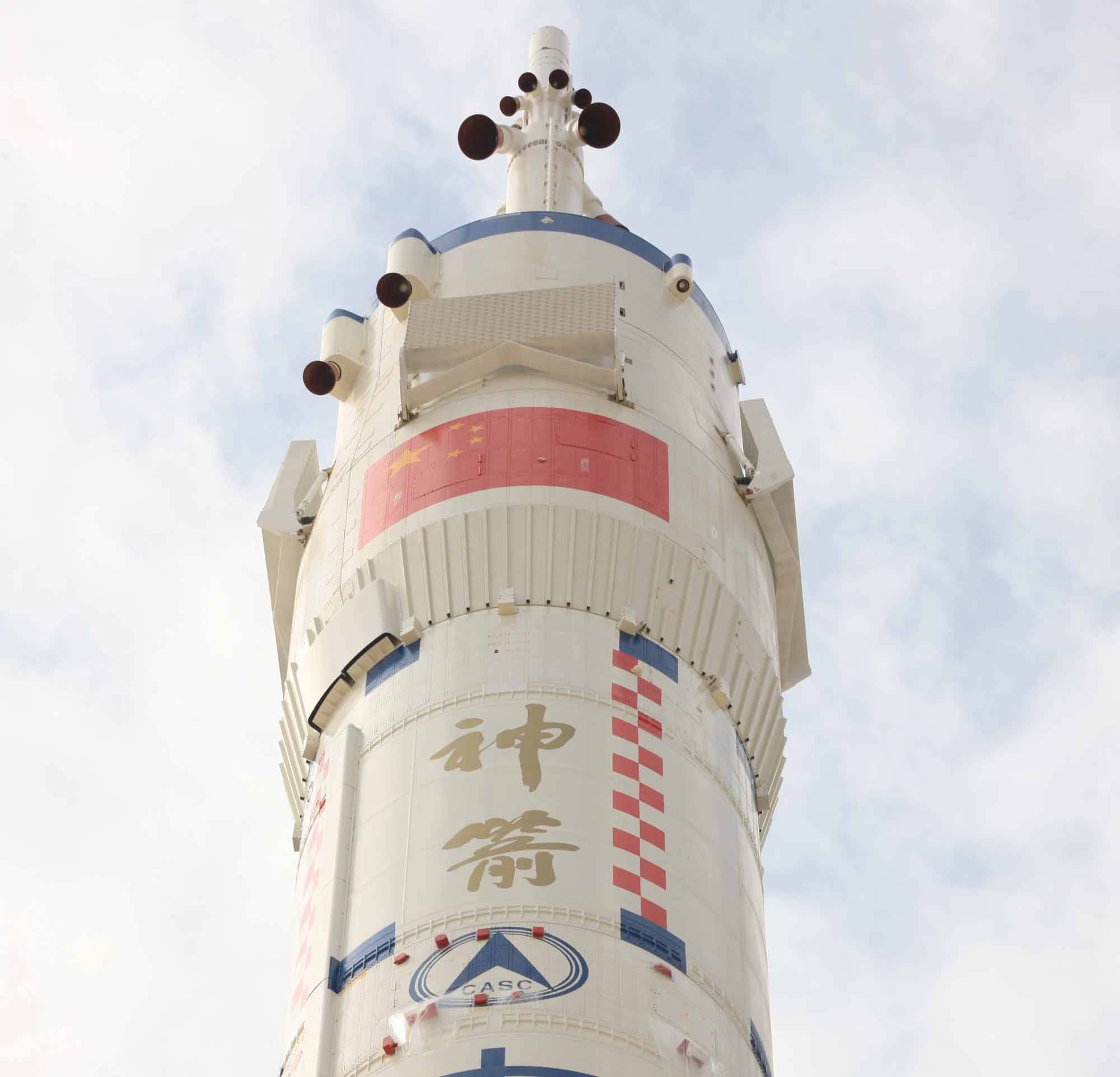
China is only the third nation (behind Russia and the United States) to have a successful manned space program, having launched its first successful manned space flight in 2003. This first mission only had a single person onboard, and gave the world a new word – ‘taikonaut’ (taikong is the Chinese word for space). The country’s next mission contained two of these taikonauts and took place in 2005. The third and most current manned mission that China has launched was launched in 2008 and held a crew of three.
Yang Liwei became the first of China's Taikonaut when he rocketed into orbit in 2003. Photo Credit: Xinhua
China has steadily, but surely, built and tested capabilities essential for a robust manned space program. Considering that China very ambitious goals for space this would seem a prudent course of action. China has stated publically that they want to launch a space station and send their taikonauts to the moon – neither of which are small feats.
China currently utilizes its Shenzhou spacecraft atop the Long March 2F booster from their Jiuquan facility. However, if China wants to accomplish these goals, they will need a more powerful booster. This has been part of the reason that the U.S. has been hesitant to include China due to concerns about the use of what are known as dual-use technologies (rockets that can launch astronauts can also launch nuclear weapons).
Both China's rocket and spacecraft are derived from Soviet Soyuz designs. Photo Credit: Xinhua/Wang Jianmin
Some have raised concerns about the nation’s human rights track record. It should be noted however that Russia had similar issues before being included in the International Space Station program.
“In the early 1990’s, some at NASA thought having Russian cosmonauts on the Space Shuttle would mean giving away trade secrets to the competition,” said Pat Duggins, author of the book Trailblazing Mars. “It turned out Russian crew capsules saved the International Space Station when the Shuttles were grounded after the Columbia accident in 2003. So, never say never on China, I guess.”
Duggins is not the only space expert who feels that China would make a good companion when mankind once again ventures out past low-Earth-orbit.
“One of the findings of the Augustine Commission was that the international framework that came out of the ISS program is one of the most important. It should be used and expanded upon for use in international beyond-LEO human space exploration,” said Dr. Leroy Chiao a veteran of four launches and a member of the second Augustine Commission. “My personal belief is that countries like China, which is only the third nation able to launch astronauts, should be included. My hope is that the politics will align soon, to allow such collaboration, using the experience that the US has gained in working with Russia to bring it about.”
Not everyone is completely convinced that China will be as valuable an asset as the Russians have proven themselves to be however.
“It is an interesting scenario with respect to the Chinese participation in an international effort in space. The U.S. has made some tremendous strides in terms of historical efforts to bridge the gap with the Russians and the results have been superb,” said Robert Springer a two-time space shuttle veteran. “The work that has resulted in the successful completion of the International Space Station is an outstanding testimony to what can be done when political differences are set aside in the interest of International cooperation. So, there is a good model of how to proceed, driven somewhat by economic realities as well as politics. I am not convinced that the economic and political scenario bodes well for similar results with the Chinese. It is a worthwhile goal to pursue, but I am personally not convinced that a similar outcome will be the result, at least not in the current environment.”
China's journey into space has just begun, but it remains to be seen if they will be going it alone or as part of a partnership. Photo Credit: Xinhua
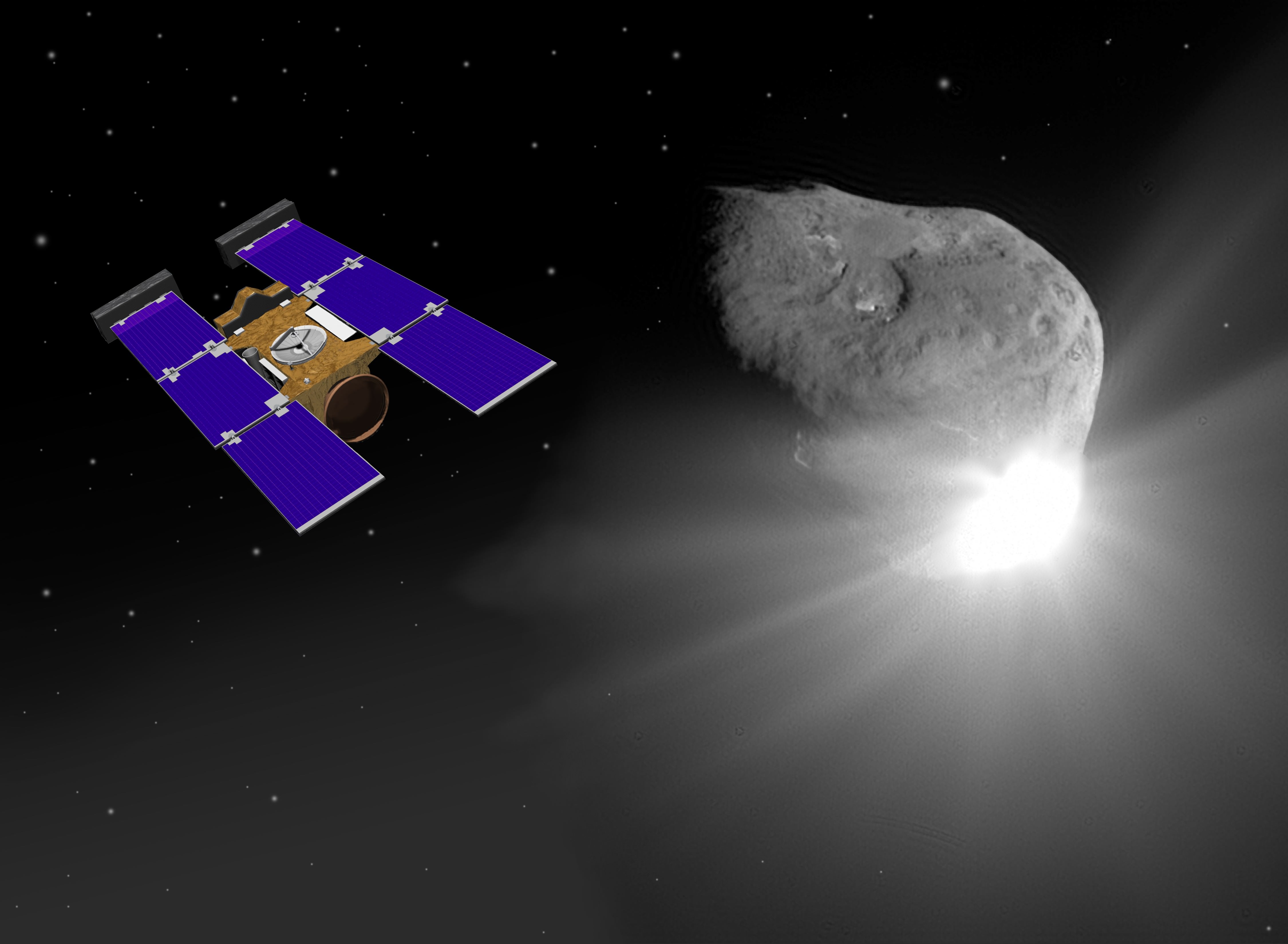
Stardust-NExT Spacecraft & Comet Tempel 1. Artist rendering of Stardust-NExT spacecraft nearing comet Tempel 1.
[/caption]
35 Days and Counting !
NASA’s re-purposed STARDUST- NeXT spacecraft is set to flyby Comet Tempel 1 at a distance of just 200 km on Valentine’s Day – February 14, 2011 at about 8:36 p.m. PST. The encounter marks the first time that a comet has been visited twice by probes from Earth. The revisit also provides the first opportunity for up-close observations of a comet both before and after a single orbital pass around the sun.
Comet Tempel 1 was first visited by NASA’s Deep Impact comet smashing mission in July 2005. Deep Impact delivered a 375 kg projectile into the path of Temple 1 that resulted in a high speed impact directly into the comet nucleus.
The cosmic collision of about 10.2 km/sec (22,800 miles/hour) ejected a cloud of debris that was studied by the Deep Impact spacecraft as well as an armada of orbiting and ground based telescopes. The impact crater itself was obscured by the debris cloud. The spacecraft did find the first evidence of surface ice on a comet instead of just inside a comet. Stardust NExT will take images and spectra of Tempel 1 and hunt for the impact crater.
Artists concept of NASA’s STARDUST- NeXT probe which will fly by Comet Tempel 1 on Feb. 14, 2011. Credit: NASA
According to the latest update posted at the STARDUST- NeXT mission website on Jan 6; “The spacecraft is healthy and began the New Year with a cold boot to clear a memory address latch-up that had occurred late in 2010. This cold boot clears the latched line and resets the memory to its factory settings.”
The reboot was completely successful and sets the probe up to accomplish the missions science objectives. On board optical navigation cameras were scheduled to take a new set of images on Jan. 6.
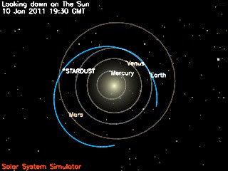
The update further states that the mission plan has now changed substantially to accommodate two new challenges. First the estimated fuel remaining on board is lower than expected. Second, the optical navigation cameras failed to detect the comet in the prior set of images in December. 10 Jan. 2011 Position of STARDUST-NeXT probe - Looking Down on the Sun. This image shows the current position of the STARDUST spacecraft and the spacecraft's trajectory (in blue) around the Sun. Credit: NASA
The optical cameras provide the key information to precisely navigate the probe to the comet. “Current estimates show that the comet may not be bright enough to detect with the Navcam until the latter half of January,” states the update.
As a result of the lower fuel estimate the remaining trajectory maneuvers (TCM’s) have been adjusted to January 31, February 7, and February 12. No science images will be taken until the last 7 days prior to the Feb 14 encounter.
Caption: Video of Comet Tempel 1 as NASA’s Deep Impact comet spacecraft delivers a projectile which smashed into the comet in July 2005. NASA’s STARDUST- NeXT probe is set to flyby Comet Tempel 1 on February, 14, 2011. The probe will collect numerous high resolution images of the coma and nucleus and hunt for the elusive 2005 impact crater.
The team states that these changes will provide “positive fuel margin through encounter …. and places the TCMs at times best able to accommodate late detection of the comet”.
The engineering team is building new approach sequences to accommodate these significant changes to the approach and Comet Tempel 1 encounter on Feb 14.
A briefing by the science team will be carried live on NASA TV on Jan. 19 at 2 PM EST
The Stardust spacecraft accomplished its original goal of flying through a dust cloud surrounding the nucleus of comet Wild 2 in Jan. 2004. The probe successfully gathered particles of cometary material during the flyby, The comet particles were returned to Earth aboard a sample return capsule which landed in the Utah desert in January 2006.
Comet particle tracks in aerogel returned to Earth by STARDUST in January 2006
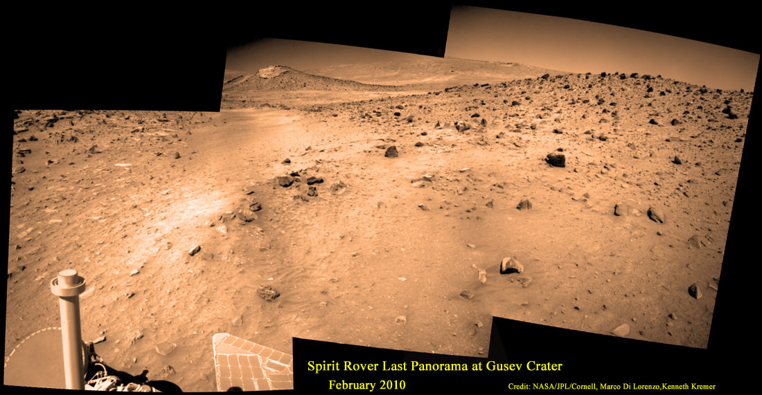
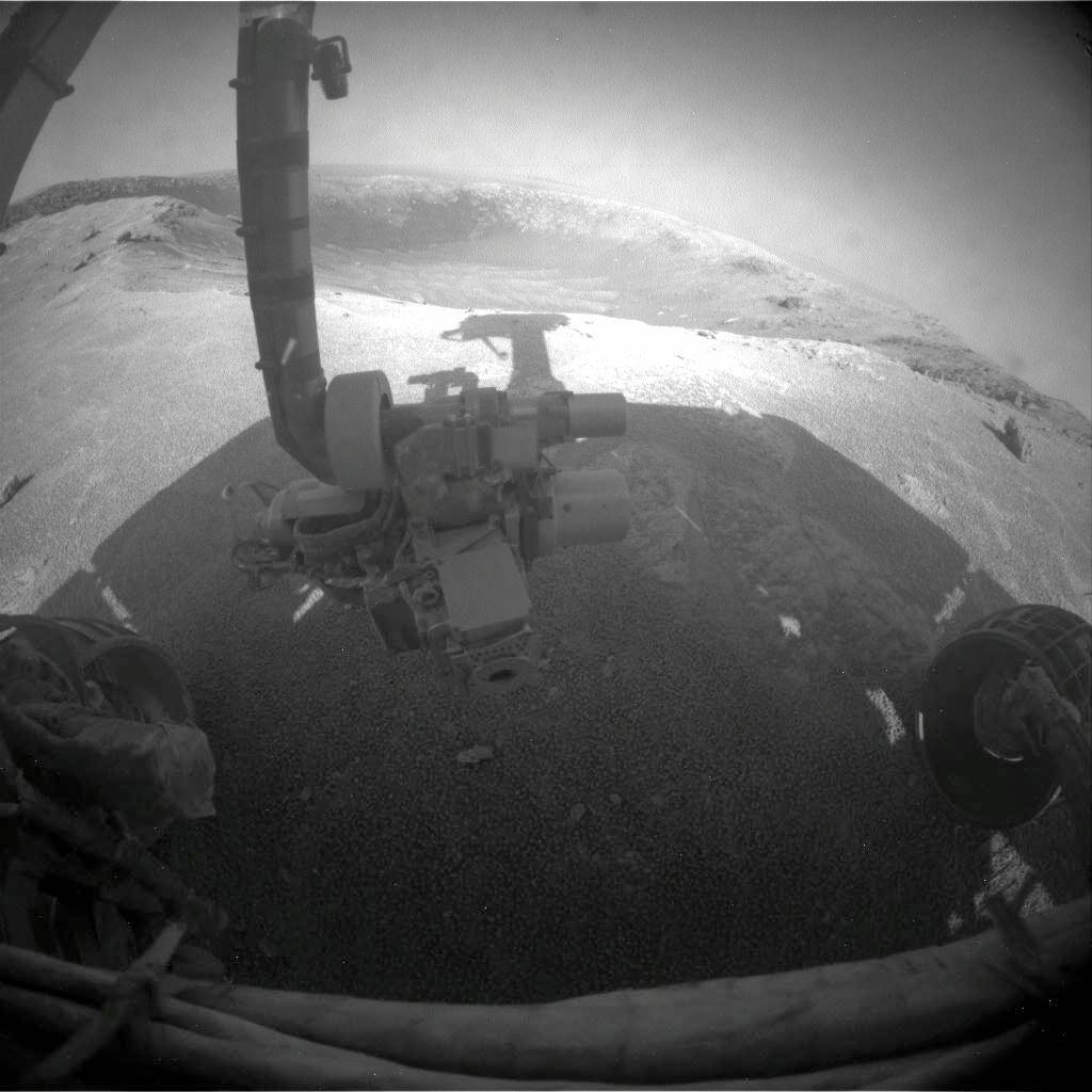
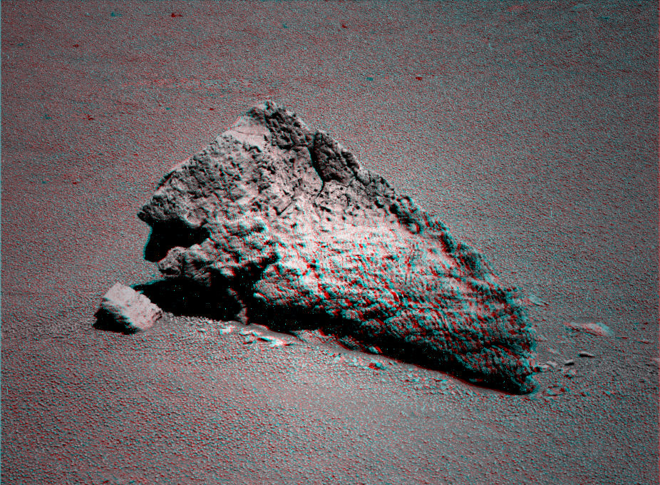
Spirit’s Last Picture Show - for now. Spirit’s final panoramic mosaic was taken on Sol 2175 in February 2010, a few weeks before entering hibernation mode in March 2010 just prior to the onset of her 4th winter on Mars. The Columbia Hills serve as a backdrop in this image. The rover is stalled in a sand trap called Troy adjacent to the Home Plate volcanic feature in Gusev Crater. Von Braun mound, left of center, was next driving target for science until Spirit became mired in sulfate rich soil - which indicates significant past flow of liquid water in this region of Mars. Credit: NASA/JPL/Cornell, Marco Di Lorenzo, Kenneth Kremer
[/caption]
No one is giving up hope for Spirit. Not Yet. And neither should you.
It’s too soon to turn out the lights. Indeed NASA is stepping up operational efforts to contact the plucky rover – More communications commands; more listening time; more frequencies. Spirit last communicated with mission controllers back on Earth on March 22, 2010. The rover entered hibernation mode – some nine months ago – as the available sunlight to power the life giving solar panels was diminishing. NASA hopes to reawaken Spirit from a long slumber and reignite her breakthrough campaign of exploration and discovery from a scientific goldmine on the surface of the red planet.
“The sun is still rising on Mars,” says Ray Arvidson in an interview from Washington University in St. Louis. Arvidson is the deputy principal investigator for the Spirit and Opportunity rovers.
“We will keep listening for many months if necessary,” Steve Squyres informed me. Squyres is the Principal Scientific Investigator for the Mars Exploration Rover mission.
Carbonate-Containing Martian Rocks, False Color.
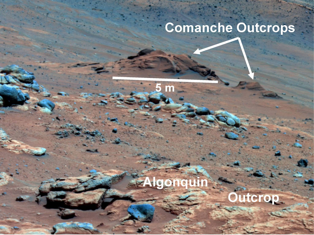
Data from Spirit collected in late 2005 has confirmed that an outcrop called Comanche contains a mineral indicating that a past environment was wet and non-acidic, possibly favorable to life.
Spirit captured this view of the Comanche outcrop during Sol 689 on Mars (Dec. 11, 2005). The rover's Mössbauer spectrometer, miniature thermal emission spectrometer and alpha particle X-ray spectrometer each examined targets on Comanche.
About one-fourth of the composition of Comanche is magnesium iron carbonate. That concentration is 10 times higher than for any previously identified carbonate in a Martian rock. Carbonates originate in wet, near-neutral conditions, but dissolve in acid. The find at Comanche is the first unambiguous evidence from either Spirit or Opportunity for a past Martian environment that may have been more favorable to life than the wet but acidic conditions indicated by the rovers' earlier finds. Credit: NASA/JPL-Caltech/Cornell University
By the time of the last dispatch from Mars, Spirit had lasted for nearly six years of bonus mission time – during the extended mission phase – light years beyond the 3 month “warranty” proclaimed by NASA as the mission began back in January 2004.
At Spirit’s location in the southern hemisphere of Mars, Southern Summer has not yet arrived. Right now it’s mid Southern Spring and daylight hours are increasing. And Summer doesn’t even start until mid-March 2011. The question is whether Spirit’s unheated electronics components have endured the extremely harsh and frigidly cold conditions of her 4th winter on Mars – her coldest ever. At about -100 C … Imagine Antarctica !
“The amount of solar energy available for Spirit is still increasing every day for the next few months,” said Mars Exploration Rover Project Manager John Callas of NASA’s Jet Propulsion Laboratory (JPL) , Pasadena, Calif. “As long as that’s the case, we will do all we can to increase the chances of hearing from the rover again.”
“We’re stepping up our efforts to contact Spirit — doubling down on her, as it were,” tweeted JPL mars rover driver Scott Maxwell.
And all those negative stories you may have read about Spirit being “Still Stuck” … well they totally missed the point.
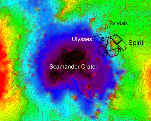
A topographical map showing where Spirit became mired in loose, sulfate rich soil at a depression called Scamander Crater, about 8 meters (26 feet) wide and 25 centimeters (10 inches) deep. The total relief indicated by the color differences is about half a meter (20 inches) from the higher ground (color coded red) to the lower ground (color coded black). The map covers an area 12 meters (39 feet) wide from west to east. North is to the top.From its embedded position, the rover used its robotic arm to examine the patch of bright soil it had exposed, called Ulysses. The map indicates that Spirit is situated with its left wheels within the crater and right wheels outside the crater. Credit: NASA/JPL-Caltech/Ohio State University
In the final Sols, or Martian days, before falling silent in March 2010, there was dramatic movement by Spirit. “During the last 9 drives, Spirit actually moved 34 cm. That’s pretty good for a stationary rover,” Arvidson said.
This movement came despite the loss of two of the rover’s six wheels and after many months of methodical testing in the “Mars sand box”. Engineers at JPL devised and tested numerous strategies in attempting to extricate Spirit from the sand trap of soft soil in which she became mired.
Because of the declining sun and available power, Spirit basically just ran out of time to try and completely escape from the sand trap. This left it unable to obtain a favorable tilt for solar energy during the rover’s fourth Martian winter, which began last May.
Many members of the rover team are hopeful that they can indeed “Free Spirit” if she awakens from her current hibernation mode.
“I have no idea whether we’ll hear from Spirit again or not… there’s simply no way to predict it,” Squyres told me. “We will keep listening for many months. All we can do is listen”
Even if we never hear from Spirit again, she has accomplished a remarkable series of scientific breakthroughs, far beyond the wildest dreams of the science and engineering teams that built and operate the twins.
Spirit discovered a rock that contained high levels of carbonates, minerals that form in neutral watery conditions that are far more conducive to the formation of life than the acidic watery conditions reported earlier in the mission.
Although Spirit has been stalled at a place called ‘Troy’ since April 2009. she made a significant science discovery at that exact spot. Spirit examined the soil in great detail and found key evidence that water, perhaps as snow melt, trickled into the subsurface fairly recently and on a continuing basis.
While driving on the western edge of an eroded over volcanic feature named ‘Home Plate’, she unknowingly broke through a hard surface crust (perhaps 1 cm thick) and sank into hidden soft sand beneath. At ‘Troy’, Spirit discovered that the crust was comprised of water related sulfate materials and therefore found evidence for the past flow of liquid water on the surface of Mars – a great science discovery!
After mid-March, prospects for reviving Spirit would begin to drop, say NASA officials. Communication strategies would change based on reasoning that Spirit’s silence is due to factors beyond just a low-power condition. Mission-ending damage from the cold experienced by Spirit in the past Martian winter is a real possibility.
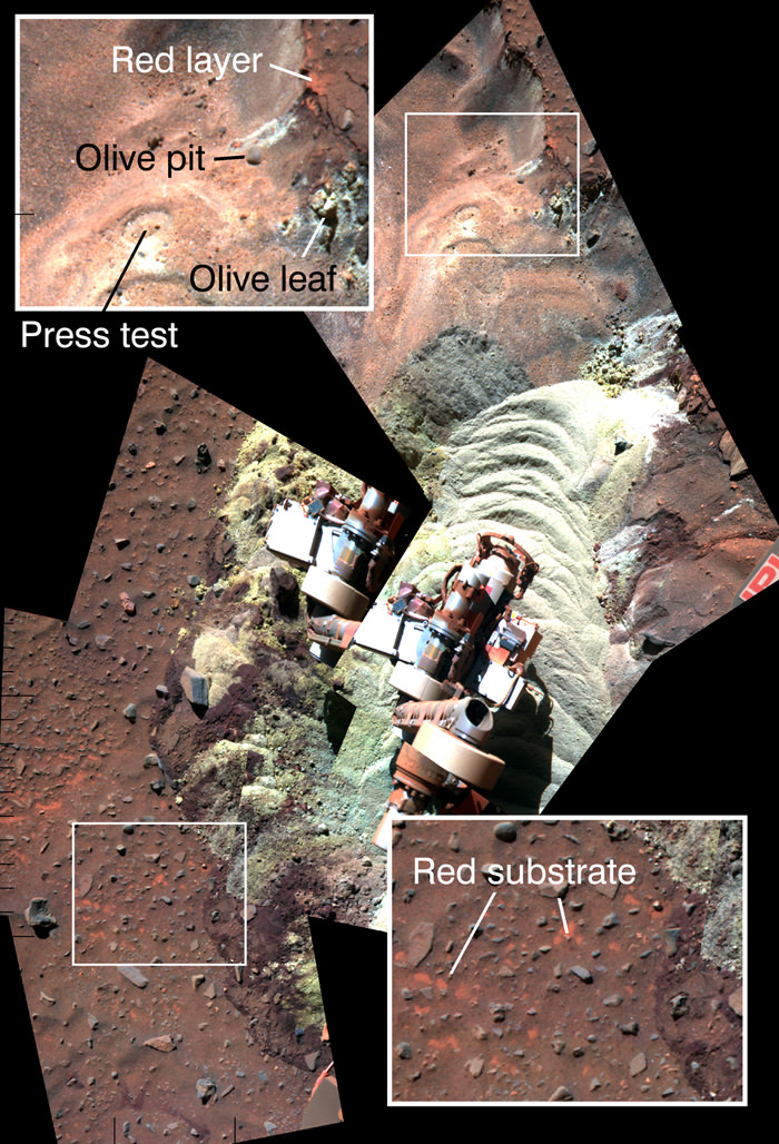
This mosaic of images shows the soil in front of NASA's Mars Exploration Rover Spirit after a series of short backward drives during attempts to extricate the rover from a sand trap in January and early February 2010. It is presented in false color to make some differences between materials easier to see. Bright-toned soil was freshly exposed by the rover's left-front wheel during the drives and can be seen with a sand wave shaping that resulted from the unseen wheel's action.
Spirit's panoramic camera (Pancam) took the component images during the period from the 2,163rd to 2,177th Martian days, or sols, of Spirit's mission on Mars (Feb. 2 to Feb. 16, 2010). The turret at the end of the rover's arm appears in two places because of movement during that period. Insets in the upper left and lower right corners of the frame show magnified views of the nearby inscribed rectangles within the mosaic. The patch of ground within each rectangle is about 25 centimeters (10 inches) across. The top inset and upper portion of the mosaic include targets within soil layers exposed by the action of Spirit's wheels in April 2009 and examined in detail with instruments on Spirit's arm during the five subsequent months.
Olive pit and Olive leaf are two of the analyzed targets. The investigations determined that, under a thin covering of windblown sand and dust, relatively insoluble minerals are concentrated near the surface and more-soluble ferric sulfates have higher concentrations below that layer. This pattern suggests water has moved downward through the soil, dissolving and carrying the ferric sulfates. The brightness and color of the freshly disturbed soil seen in the center area of the mosaic indicates the this formerly hidden material is sulfate-rich. Before Spirit drove into this patch, the surface looked like the undisturbed ground highlighted in the lower-right inset. Flecks of red material in the surface layer resemble the appearance of the surface layer at other locations where Spirit's wheels have exposed high-sulfate, bright soils. Image Credit: NASA/JPL-Caltech/Cornell University
Spirit entered a low-power fault mode in March 2010 with minimal activity except charging and heating the batteries and keeping its clock running. With most heaters shut off, Spirit’s internal temperatures dipped lower than ever before on Mars. That stress could have caused damage, such as impaired electrical connections, that would prevent reawakening or, even if Spirit returns to operation, would reduce its capabilities.
“Components within the rover electronic module (REM) inside the rover’s warm electronic box (WEB) are experiencing record low temperatures,” said Doug McCuistion, the director of Mars Exploration at NASA Headquarters in Washington, DC, in an interview about Spirit’s predicament. “The expectation is for the REM hardware to reach -55C at the coldest part of the winter. We have tested the REM down to -55C”.
NASA’s Deep Space Network of antennas in California, Spain and Australia has been listening for Spirit daily in coordination with the spacecraft orbiting Mars; Mars Odyssey and Mars Reconnaissance Orbiter. In X-band, the DSN listens for Spirit during one pass each day. The rover team has also been sending commands to elicit a response from the rover even if the rover has lost track of time.
Now, the monitoring is being increased. Additional listening periods include times when Spirit might mistake a signal from NASA’s Mars Reconnaissance Orbiter as a signal from Earth and respond to such a signal. Commands for a beep from Spirit will be sent at additional times to cover a wider range of times-of-day on Mars when Spirit might awaken.
“DSN does an average of 4 “sweep & beep” commands in each day’s pass,” according to JPL spokesman Guy Webster. Also, NASA is listening on a wider range of frequencies to cover more possibilities of temperature effects on Spirit’s radio systems
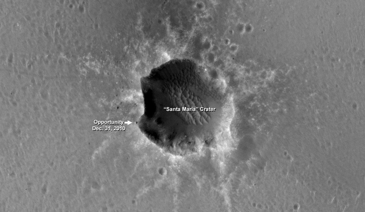
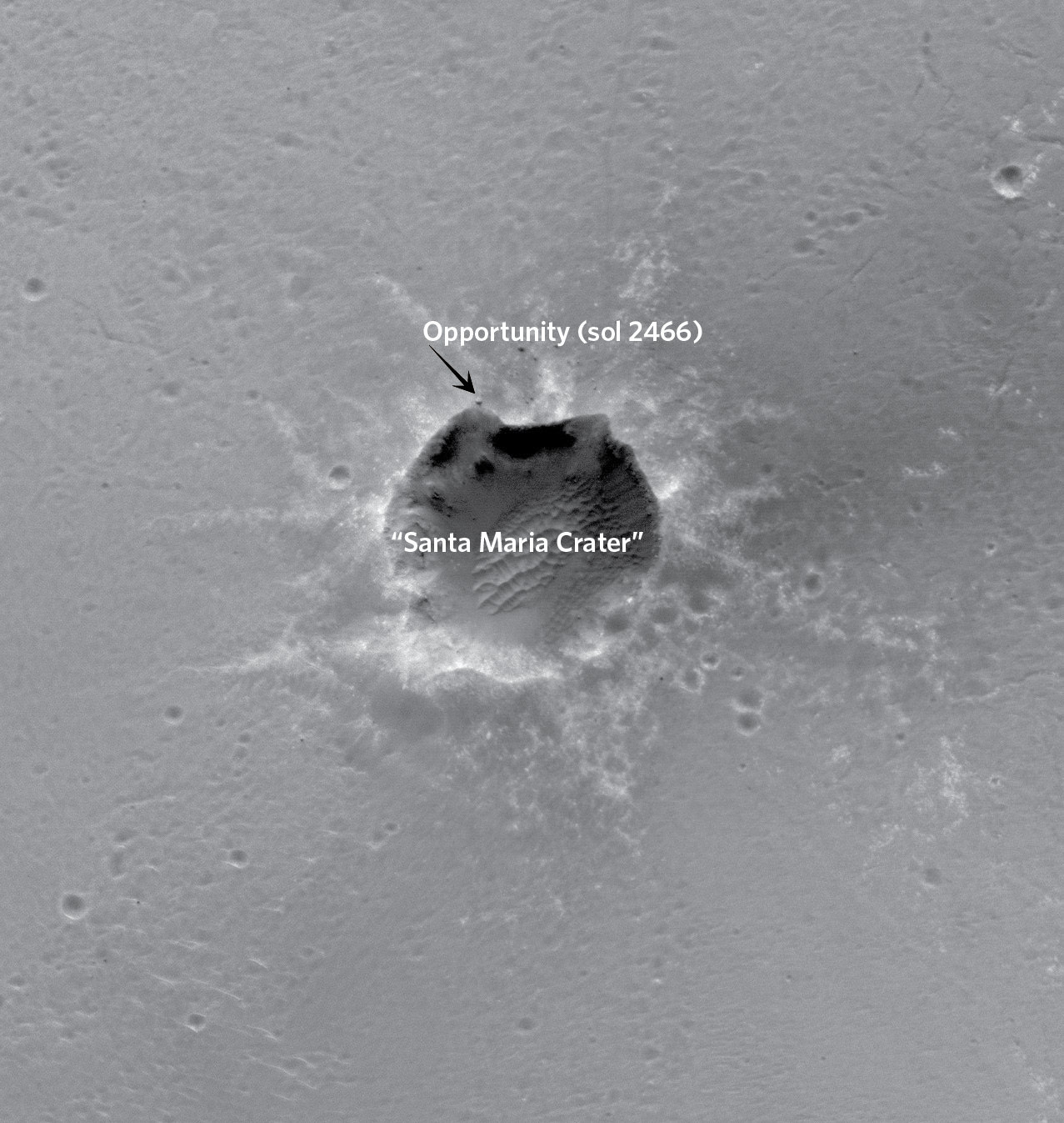
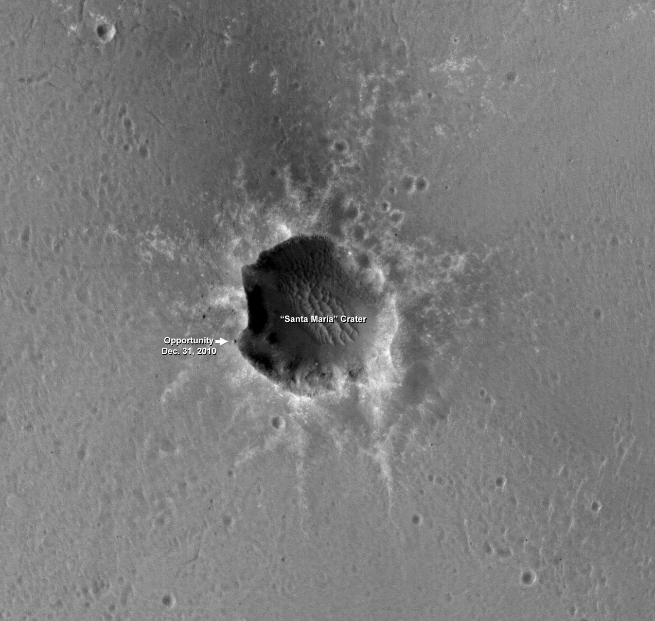
Opportunity rover at the SW rim of Santa Maria Crater on New Year's Eve 2010 - Sol 2466. The rover sits at the edge of the crater rim and was photographed from Mars orbit by the HiRISE camera aboard NASA’s Mars Reconnaissance Orbiter. Look closely to see the rover tracks on the left as Opportunity approached the westerm rim of Santa Maria crater. Credit: NASA/JPL/University of Arizona
[/caption]
“I enjoy seeing our rover again,“ says Steve Squyres in an exclusive for Universe Today. Squyres is the top scientist for the Opportunity and Spirit Mars rovers.
NASA’s Opportunity rover was just been photographed from Mars Orbit while perched at the precipice of Santa Maria crater – just meters away from the edge of the Southwest rim. The photo was taken on New Year’s Eve, Dec. 31, 2010 on Sol 2466 of the mission which has lasted nearly 7 years ! Opportunity landed on Mars on Jan. 24, 2004.
“Well, it’s always great to see images like that,” Steve Squyres just informed me after seeing the new photos of Opportunity. Squyres, of Cornell University, is the Principal Scientific Investigator for NASA’s Spirit and Opportunity Mars rovers.
“This one reminds me a lot of the first time we ever saw a rover from orbit, just after Opportunity had arrived at the rim of Victoria crater. It’s a very evocative scene, and it’s hard not to project certain things onto the rover (“valiant”, “lonely”) when you see it. Mostly, though, I just enjoy seeing our rover again.”
“The last time I laid eyes on Opportunity was about seven and a half years ago, and it’s nice getting another glimpse of her,” said Squyres.
Oblique view of Opportunity on New Years Eve 2010 from Mars Orbit. HiRISE also took an an oblique view of the same area of Mars. This image shows the view looking West, as MRO pointed off nadir 18 degrees to the West to acquire this oblique image, similar to the view out an airplane window. Credit: NASA/JPL/University of Arizona
Opportunity arrived at the western rim of Santa Maria on Dec. 16 (Sol 2451) after a long and arduous trek of some 19 km since departing from Victoria Crater over 2 years ago in September 2008.
The rover has been exploring around the western portion of Santa Maria crater since arriving and is now heading to the southeast rim which possesses deposits of hydrated minerals.
Opportunity drove some 40 meters south along the steep rim from the initial location at “Palos” Promontory and then bumped incrementally further up to the edge on Sol 2464 at a place dubbed “Wanahani”.
The rover was photographed from Mars orbit while perched at “Wanahani” on New Years Eve, Dec 31, 2010 on Sol 2466.
“We are driving the vehicle in a counterclockwise direction around Santa Maria to reach the very interesting hydrated sulfates on the other side,” according to Ray Arvidson, the deputy principal investigator for the rovers, in an interview from Washington University in St. Louis. “We’ll make 3 stops or more depending on what we see”
Simultaneously to being photographed from orbit, the rover itself was of course merrily snapping a ground level view of Santa Maria. To experience the surface eye view from Opportunity, see our photo mosaic – stitched from the raw images – to display the rovers panoramic perspective whilst gazing outwards from “Wanahani” to the cliffs of Santa Maria on Sols 2464 and 2466.
Opportunity’s surface view of Santa Maria on New Years Eve Dec 31 while being photographed overhead from Mars Orbit.
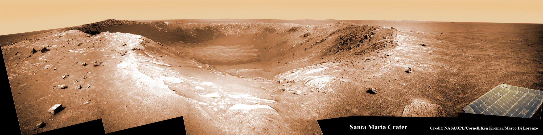
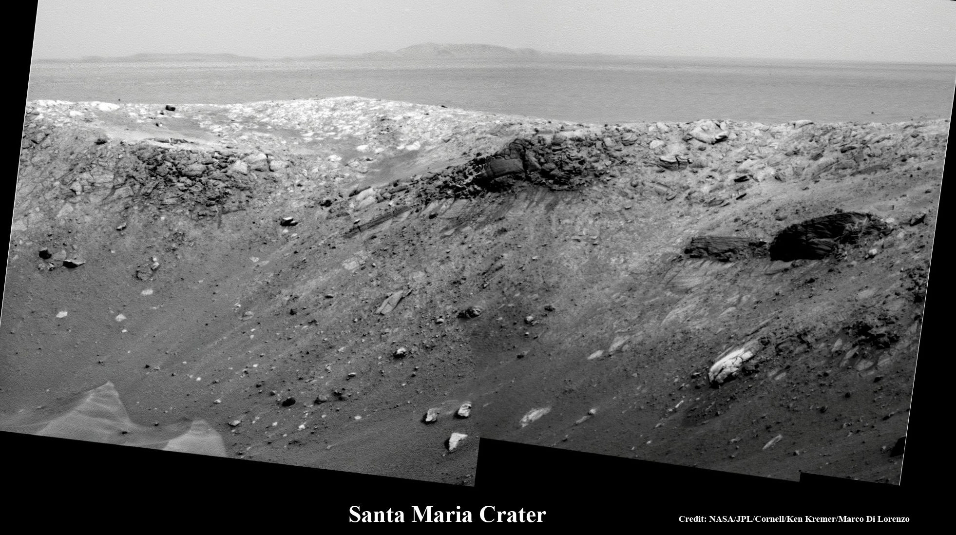
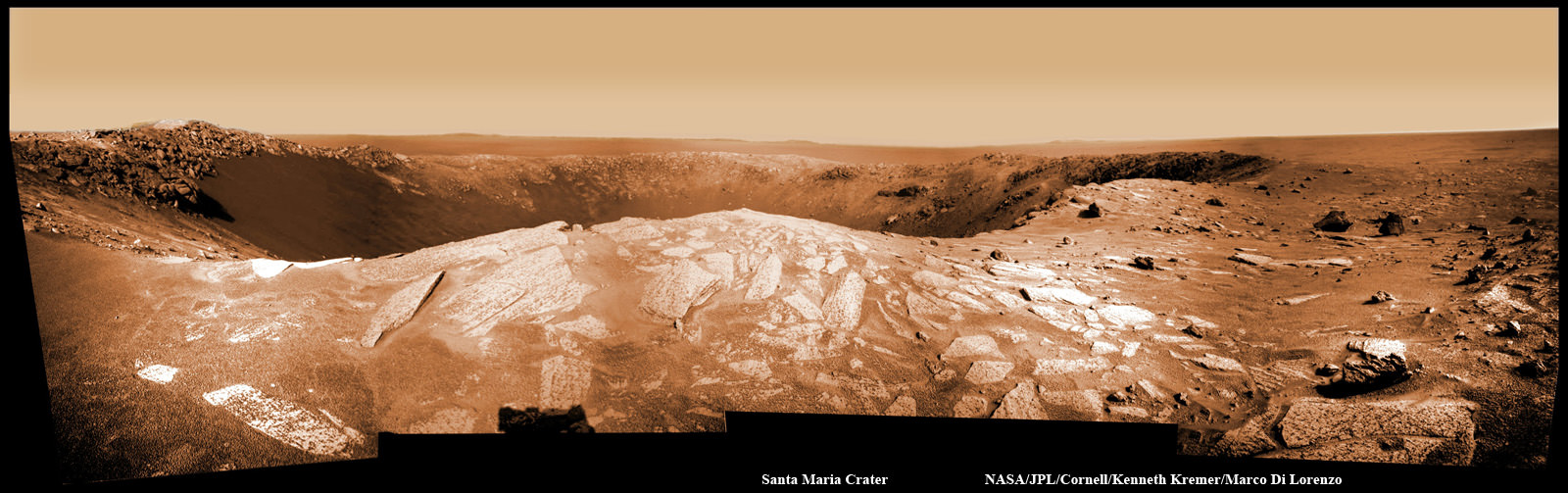
Wanahani outlook at Santa Maria Crater. Opportunity took this panaromic mosaic from “Wanhani” just meters from the crater rim on Dec 29, 2010 (Sol 2464). Note rover tracks near rim at left, relatively clean solar panel at right and numerous ejecta rocks. The rim is inclined roughly 5 degrees here. CRISM mapper results suggest water bearing materials are located at the southeastern edge of the crater rim, nicknamed “Yuma”. Portions of distant Endeavour Crater are faintly visible as bumps on the horizon in the background. Mosaic Credit: NASA/JPL/Cornell, Ken Kremer, Marco Di Lorenzo
“Opportunity is imaging the crater interior to better understand the geometry of rock layers as a means of defining the stratigraphy and the impact process, says Matt Golembek, Mars Exploration Program Landing Site Scientist at the Jet Propulsion Laboratory (JPL), Pasadena, Calif.
Santa Maria is a relatively young, 90 meter-diameter impact crater (note blocks of ejecta around the crater), but old enough to collect sand dunes in its interior.
Santa Maria Crater, located in Meridiani Planum, is about 6 kilometers from the rim of Endeavour Crater, which contains spectral indications of phyllosilicates, or clay bearing minerals that are believed to have formed in wet conditions that could have been more habitable than the later acidic conditions in which the sulfates Opportunity has been exploring formed.
Data from the CRISM mineral mapper aboard MRO data show indications of hydrated sulfates on the Southeast edge of the Santa Maria Crater at which Opportunity is planning on spending the upcoming solar conjunction. After that, Opportunity will traverse to the Northwest rim of Endeavour Crater, aided tremendously by HiRISE images like the one here for navigation and targeting interesting smaller craters along the way.
Opportunity rover at the SW rim of Santa Maria Crater on New Year's Eve 2010 - Sol 2466. The rover sits at the edge of the crater rim and was photographed from Mars orbit by the HiRISE camera aboard NASA’s Mars Reconnaissance Orbiter. Look closely to see the rover tracks on the left as Opportunity approached the westerm rim of Santa Maria crater. Credit: NASA/JPL/University of Arizona
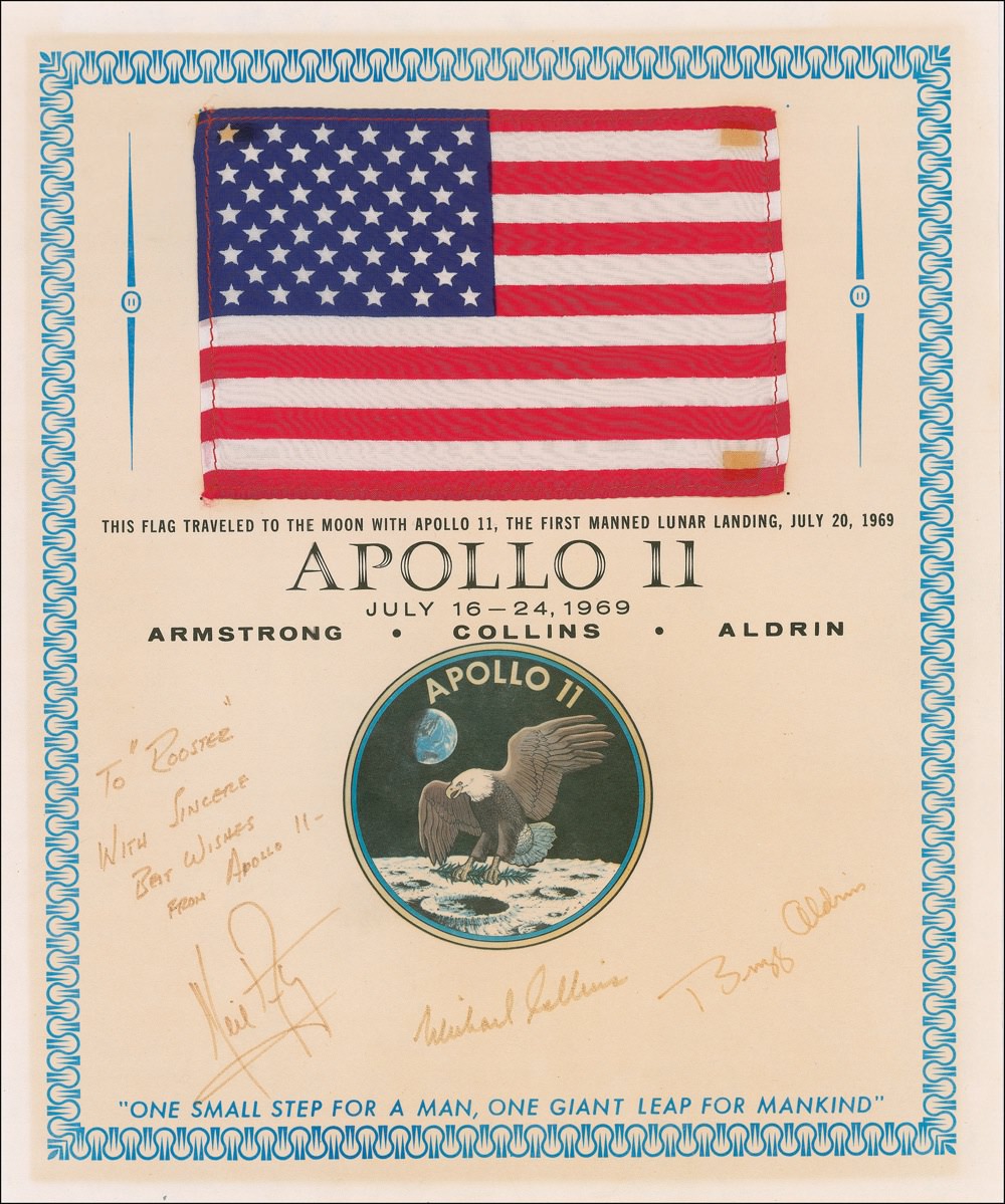
This flag flew to the Moon and back with the Apollo 11 crew. It's one of the many items from the history of spaceflight up for sale at an upcoming auction. Image Credit: RR Auction
[/caption]
If you’re interested in owning an artifact or two from the history of spaceflight, now could be your chance to snag some up. From January 13-20, over 400 artifacts relating to the history of spaceflight will be up on the auction block at RR Auction. There’s a diverse number of different pieces, ranging from an Atlas I and II crow’s foot wrench to numerous items that flew aboard many of the Apollo missions and on Projects Mercury and Gemini.
There are even a few spare parts for the Shuttle, though it’s probably not a good idea to follow along in Johnny Cash’s footsteps; if you build a space shuttle one piece at a time, it’ll cost you more than a dime and I doubt you’ll want to fly it into space.
This auction is filled with loads of memorabilia – much of it signed by astronauts or other NASA personnel – from the Apollo missions. There is a US flag that flew with the Apollo 11 crew to the Moon and back, attached to a certificate signed by Armstrong, Aldrin and Collins. As you can imagine, this one is going to go for a lot – the bidding starts at $2500. If you drill it out so it'll fit, and with a little help from an A-daptor kit, you could have a shuttle running just like a song. Image Credit: RR Auction. Mangled lyrics credit: The Man in Black
One piece that has been getting a lot of attention – and will probably also sell for quite a lot, given that it starts out at $1000 – is the original page from the November 1969 Playboy magazine featuring topless Playmate DeDe Lind. The page was stuck to a piece of cardboard aboard Apollo 12, and traveled all the way to the Moon and back aboard the Yankee Clipper.
It’s accompanied by a certificate of authenticity from Richard Gordon, the Apollo 12 Command Module pilot, which reads in part: “This cue card, which flew with me to the moon, has been in my sole possession and part of my personal space collection since my return from the moon in 1969 aboard America’s second lunar landing mission, and it remains one of the all-time greatest Apollo era astronaut ‘Gotcha’s!’” Historic, indeed.
Wanahani outlook at Santa Maria Crater. Opportunity took this panaromic mosaic from “Wanhani” just meters from the crater rim on Dec 29, 2010 (Sol 2464). Note rover tracks near rim at left, relatively clean solar panel at right and numerous ejecta rocks. CRISM mapper results suggest water bearing materials are located at the southeastern edge of the rim located at the southeastern section of the crater. Portions of distant Endeavour Crater are faintly visible as bumps on the horizon in the background. Mosaic Credit: NASA/JPL/Cornell, Ken Kremer, Marco Di Lorenzo
[/caption]
A robot from Earth is celebrating New Years on Mars by snapping another amazing set of “Postcards from the Edge” while perched near the sharp edge of a crater cliff on the red planet. NASA’s Opportunity rover is now stationed just meters away from a new precipice at the stunningly beautiful crater named Santa Maria. The twin rovers mark their 7th anniversary on Mars this week. See martian postcard mosaics above and below.
Craters expose the hidden history of Mars and permit scientists a path to explore the past geologic epochs which otherwise would remain buried and inaccessible.
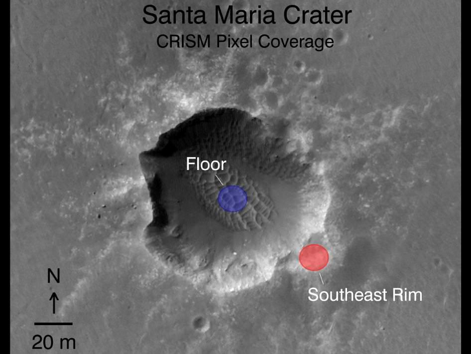
Santa Maria Crater from Orbit. Opportunity arrived at the western rim of Santa Maria Crater, some 90 meters wide, on Dec. 16, 2010 at a spot called “Palos”. Opportunity then drove in a counterclockwise direction to a spot called “Wanahani” at the southern edge. It is collecting high resolution imagery and spectral data over New Years and will then resume driving to its next destination at the Southeast rim, an area nicknamed “Yuma”. See new annotations. Researchers are using data collected by the CRISM mineral mapping spectrometer aboard NASA’s Mars Reconnaissance Orbiter (MRO) to direct the route which Opportunity is traversing on Mars during the long term journey to Endeavour crater. Spectral observations recorded by CRISM indicates the presence of water-bearing sulfate minerals at the location shown by the red dot on the southeast rim crater whereas the crater floor at the blue dot does not. This image was taken by the High Resolution Imaging Science Experiment (HiRISE) camera also on MRO. Credit: NASA/JPL-Caltech/Univ. of Arizona. Santa Maria is an exciting find because it appears to be relatively new and unweathered – on the order of possibly just a few million years old. Researchers are eager to drive around the rim in order to explore deposits of water bearing minerals that contain valuable clues to the flow of liquid water on ancient Mars.
The golf cart sized rover arrived this week (Dec. 29) at an outlook nicknamed “Wanahani” near the southern edge of Santa Maria. Opportunity arrived at the western rim of Santa Maria on Dec. 16. Just before Christmas, she drove about 20 meters south along the steep rim from the initial location at Palos Promontory and then bumped incrementally further up to the edge (Sol 2464) .
Palos Promontory and Santa Maria Panorama from Opportunity on Mars.
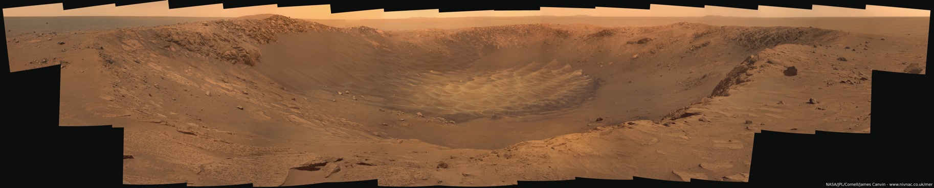
Opportunity drove within 2.5 meters of the rim and snapped this beautiful panoramic vista of the crater and distant horizon on Sol 2454. Note rover solar panel deck, antennae and sundial at left. Mosaic Credit: NASA/JPL/Cornell, Oliver de Goursac.Santa Maria from Palos Promontory on Mars.
Opportunity drove to within 2.5 meters of the rim and snapped this gorgeous panoramic vista unveiling the whole interior on Sols 2453 & 2454. Note the steep walls and sand dunes on the floor. Mosaic Credit: NASA/JPL/Cornell, James CanvinWanahani outlook at Santa Maria Crater.
Opportunity took this panaromic mosaic from “Wanhani” just meters from the crater rim on Dec 29 (Sol 2464). Note rover tracks near rim at left, solar panel at right and numerous ejecta rocks. CRISM mapper results suggest water bearing materials are located at the southeastern section of the crater. Portions of distant Endeavour Crater are faintly visible as bumps on the horizon in the background. Mosaic Credit: NASA/JPL/Cornell, Ken Kremer, Marco Di LorenzoCrater Rim Duo with Signs of Hydates on Mars.
Santa Maria rim up close (80 meters away) and Endeavour rim (6 km away) on the horizon in the distance. Both craters show mineralogical evidence for the past flow of liquid water on Mars and are high priority science targets. Mosaic Credit: NASA/JPL/Cornell, Ken Kremer, Marco Di LorenzoPartial panorama near Wanahani outlook on Sol 2461.
Undulating sand dunes on the crater floor and southern portion of Santa Maria, inclined about five degrees. Mosaic Credit: nasatech.net
But there is no time to party and relax. The rover will soon resume driving to the next location – nicknamed “Yuma”. It will continue farther around the football field sized crater – measuring some 90 meters (295 ft) in diameter – to reach the exposures of sulfated hydrates located at the southeast portion of the crater near “Yuma”.
Opportunity must be in position at an important science target before mid January and the onset of solar conjunction and a temporary communications black out with Earth. The rover will remain stationary during conjunction.
Fish eye view from Wanahani outlook. Opportunity snapped this wide angle view from the crater rim of Santa Maria with the hazard camera on Sol 2464. Credit: NASA/JPL/Cornell
At Wanahani, Opportunity is now hurriedly toiling away over the New Year’s period to collect a pair of long baseline, high resolution stereo image mosaics using it’s panoramic, multispectral imaging camera. See our initial Wanahani mosaics assembled here from the navigation camera images just received on Earth (Sol 2464).
The team is using all 13 filters on the filter wheels of the panoramic camera, according to Ray Arvidson, the deputy principal investigator for the rovers, in an interview from Washington University in St. Louis. Over the course of several days, the left and right “eyes” of the panoramic camera will gather data at various wavelengths to maximize the collection of spectral information about the hydrated minerals located in the craters interior.
Data downlink is limited by the available amount of flash memory aboard Opportunity and is the Achilles heel of rover operations. Virtually all the pictures and science is streaming back to Earth via NASA’s long lived Mars Odyssey orbiter. The team is working to get all the acquired science data offloaded as swiftly as possible,
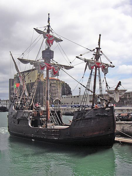
A functioning replica of the Santa Maria in Funchal harbor, Madeira Islands, Portugal.
Arvidson said that the team hopes that the meteor impact that excavated the crater also blasted some of these scientifically fascinating rocks free to spots which are more easily accessible – just outside the rim for close up analysis. Additional imaging and spectral data is also being collected from Mars orbit this new year’s weekend in hopes of quickly directing the rover to the best locations for science in the limited time available.
Opportunity will study the relatively fresh and uneroded ejecta rocks using all the instruments located at the end of the robotic arm. One target will be selected for a longer duration study during the period of solar conjunction, said Arvidson.
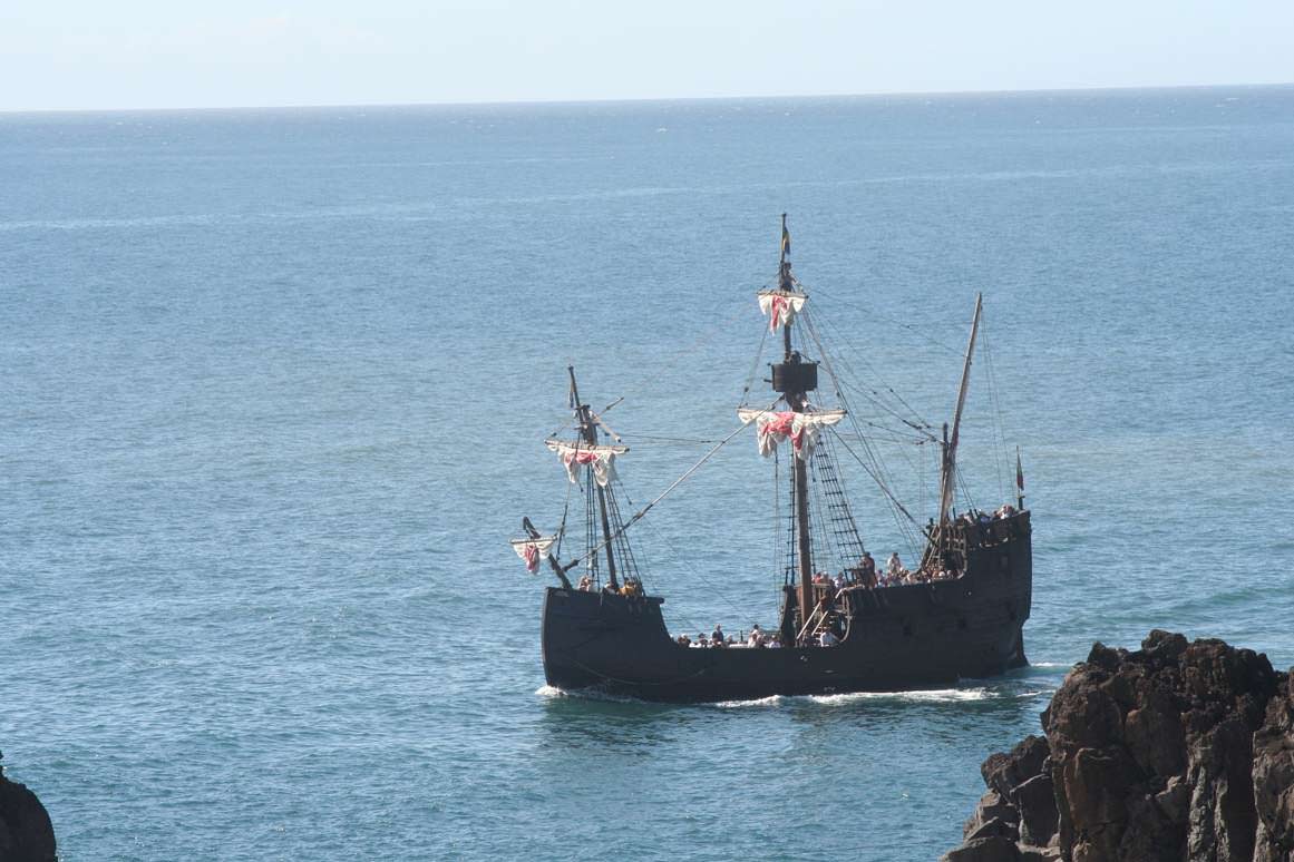
The Santa Maria replica at sea. Opportunity is on an epic expedition to a distant horizon far beyond the shores of Earth. The rover team is naming places visited around the crater rim after islands visited by Columbus during his voyages of expedition and discovery to the New World starting in 1492. The Santa Maria was the largest of the three ships used during his first voyage.
Opportunity will resume her long term trek to Endeavour crater after the end of solar conjunction in mid February. The western rim of Endeavour is about 6 km distant. Endeavour is a very compelling science target because it shows significant signatures for clay minerals which formed in the presence of neutral bodies of liquid water on Mars, billions of years ago.
Spirit and Opportunity celebrate 7 Years on Mars this month since the dynamic duo landed in January 2004. Look for my story soon.
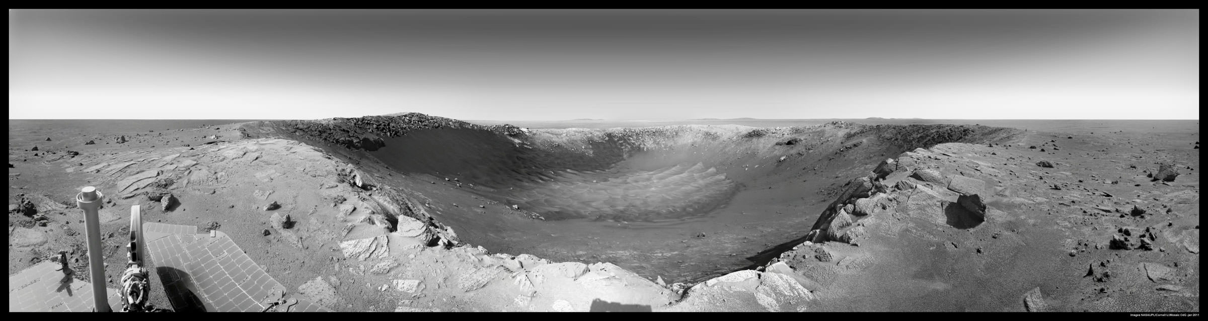
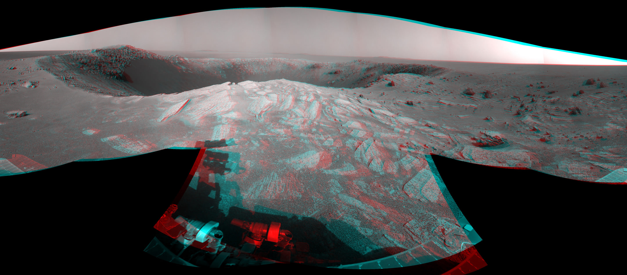
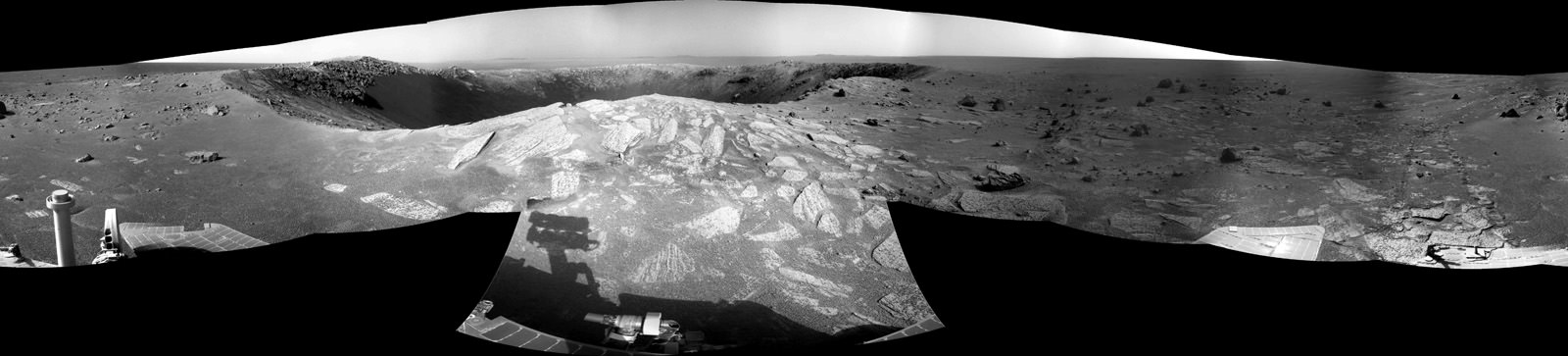
Santa Maria is a football-field-size crater - about 90 m wide and 12 m deep - which dominates the scene in this stereo view from NASA's Opportunity rover. Opportunity sits about 5 meters from the steep western edge of this scientifically interesting impact crater which displays signatures of water bearing minerals at the center of this mosaic. Opportunity arrived here following a 25-meter (82-foot) drive on the 2,451st Martian day, or sol, of the rover's work on Mars (Dec. 16, 2010). The rover used its navigation camera to take the frames combined into this mosaic. The scene appears three-dimensional when viewed through red-blue glasses with the red lens on the left. It combines images taken with the left eye and right eye of the navigation camera. Credit: NASA/JPL/Cornell.
[/caption]
Spectacular new images of a gorgeous gaping hole on Mars are streaming back to Earth from NASA’s Opportunity Mars Rover. So let’s take a 3 D stroll placing all of us at Santa Maria Crater – “On Mars”. Via the photo mosaics above and below, we will circle in three dimensions about the stunningly beautiful Santa Maria Crater. At the southeast portion of the rim, the crater also possesses a scientific goldmine of hydrated mineral deposits. These minerals are indicative of the past flow of liquid water on Mars, an essential requirement for the formation of life.
Opportunity made landfall at the western edge of Santa Maria on Dec. 15 (Sol 2450) after a long and arduous journey of some 19 km since departing from Victoria Crater over 2 years ago in September 2008. She crawled closer to the rim the next day on Dec. 16 (Sol 2451) unveiling a magnificent vista of jumbled ejecta rocks, steep sloped cliffs and undulating sand dunes across the crater floor.
“Santa Maria is a relatively fresh impact crater. It’s geologically very young, hardly eroded at all, and hard to date quantitatively. On the order of 10 million years old or less,” said Ray Arvidson in an interview from Washington University in St. Louis. Arvidson is the deputy principal investigator for the Spirit and Opportunity rovers.
Santa Maria from Palos Promontory on Mars.
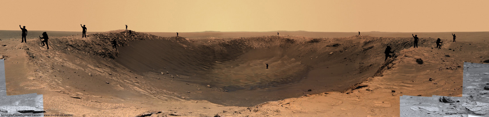
Imagine yourself at the steep cliff walls of Santa Maria crater at a place called Palos. To get a sense of scale in 2 D, human sized figures (2 m tall) have been strategically placed at multiple locations near and far, around and inside this gorgeous panoramic vista. Opportunity drove closer and snapped these images just 2.5 meters from the crater’s edge on Sols 2453 & 2454. Mosaic Credit: NASA/JPL/Cornell, James Canvin. Annotations of Mysterious men in black hats and their cousins, the French climbers by FredK and ElkDanGrove at unmannedspaceflight.com
“Santa Maria is the freshest big guy that Opportunity has seen and has a raised rim,” Arvidson told me. “It is much younger than Endurance Crater which Opportunity visited a few months after landing on Mars way back in 2004 and is roughly the same diameter.” See the entire Opportunity traverse map below.
“The crater is young enough that the interesting hydrate outcrops may not be coated with the nanophase iron oxide dust. There is virtually no erosion. We can see the ejecta rays and blocks,“ said Arvidson.
While sitting just five meters from the rim on Dec. 16, Opportunity imaged the football field sized crater – some 90 m wide – with both its left and right eye navigation cameras. A mosaic of these images was stitched together by NASA to create a stunning 360 degree stereo panoramic vista. The images are snapped from the same height seen by an adult to give the perspective that a human eye would see when standing “On Mars”.
The crater is the centerpiece of the stereo image above, which shows the crater’s sharp rim and rocks ejected from the impact that had excavated the crater. You will need to whip out your red-cyan stereo glasses to experience the full three-dimensional effect of the scene. Be sure to wear the red lens on the left, and try not to fall off the cliff.
Click here for the entire 360-degree high resolution stereo view – its 10 MB in all. South is at the center. North is at both ends. The view is presented as a cylindrical-perspective projection. The wheel tracks left behind in the Martian dirt – as the rover approached the crater – are seen at the far right and are also highlighted in our 2 D mosaic below.
Off in the distance, several portions of the rim of Endeavour Crater are visible as bumps on the horizon. Endeavour is the ultimate target of Opportunity’s long term trek across the Martian dunes at the Meridiani Planum region and is some 22 kilometers in diameter.
“Endeavour shows significant signatures of phylloslicates, or clay minerals, and water bearing sulfate minerals which formed in the presence of liquid water,” Arvidson explained. “The phyllosilicates formed at the crater rim about 3.8 to 4.2 Billion years ago and predate the sedimentary rocks which are younger than 3.8 billion years.”
Pictured below is a collection of stereo photo mosaics for a North to South up close tour around the rim of Santa Maria. Several of the images were created by members of unmannedspaceflight.com.
“Opportunity will drive in a counterclockwise direction around Santa Maria to reach the very interesting hydrated sulfates on the other side. We’ll make 3 stops or more depending on what we see”
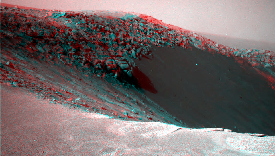
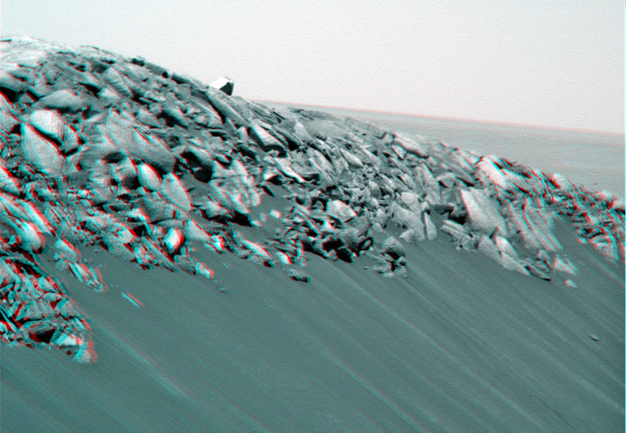
Stereo view of the sharp northern rim of Santa Maria on Sol 2451. Credit: NASA/JPL/Cornell/Stu AtkinsonConvoluted martian rocks in 3 D close up at the sharp northern rim of Santa Maria. Credit: NASA/JPL/Cornell/Walfy at unmannedspaceflight.com
“On Dec. 19 (Sol 2454) we bumped the vehicle even closer to the rim from the initial approach point, to a promontory we’ve nicknamed ‘Palos’, stated Arvidson. “Opportunity was a mere 2.5 meters from the edge. At ‘Palos’, the rover collected the first set of long baseline, high resolution stereo images for creating a 3 D digital elevation map.”
“The coves at Santa Maria will be named after the islands which Columbus visited, using the native American language. All the rocks and boulders strewn about will be named after the sailors on the voyage with Columbus,” explained Arvidson.
“This past weekend we drove about 20 meters southeast towards the second location named ‘Wanahani’. On Tuesday of this week (Dec. 28) we bumped to the edge. The plan is to photograph the ejecta rocks and collect the next set of long baseline, high resolution stereo images.”
The third stop – which must be reached before Solar Conjunction in mid January 2011- will take Opportunity to the science hot spot detected by the powerful CRISM mineral mapping spectrometer circling above Mars aboard NASA’s Mars Reconnaissance Orbiter (MRO).
“With CRISM we are trying to cover all the rim segments to better understand the nature and geologic setting of the iron and magnesium smectite clay mineral exposures. The southeast portion of Santa Maria is generally the location of the CRISM spectra that show hydrated sulfates. Opportunity will go to the southeast rim and try and find a nice outcrop on the rim side to do measurements to field verify the expected mineralogy,” explained Arvidson.
“We might do a toe dip with the wheels but there is no plan to go inside.”
“We will use the Rock Abrasion Tool (RAT) to drill into a selected target. That spot will be named after ‘Columbus’.
The exposures of hydrated sulfates have a bright toned appearence in the images.
“With the sun over the camera’s shoulder there is a phenomenon called opposition effect in which rocks and soils become particularly bright when the sun-camera-surface line up, Arvidson told me. “But, it also may be that the bright looking rocks are intrinsically bright and not coated with the nanophase iron oxide coatings we have seen on previous outcrops. All in the realm of testable working hypotheses.”
“On Dec. 30 we are planning another CRISM spectral mapping campaign with MRO over Santa Maria,” said Arvidson. “Using a new technique which gimbals, or swivels, the CRISM optics we hope to use a pixel overlap technique to improve the ground resolution from 18 meters across to 6 meters across. This data will be used in tactical decisions about where to drive on Mars.”
Read more of my interview with Ray Arvidson in the next feature story describing the exciting plan for science exploration at Santa Maria and Endeavour, the outlook for Spirit and more – along with new mosaics from “Wanahani”.
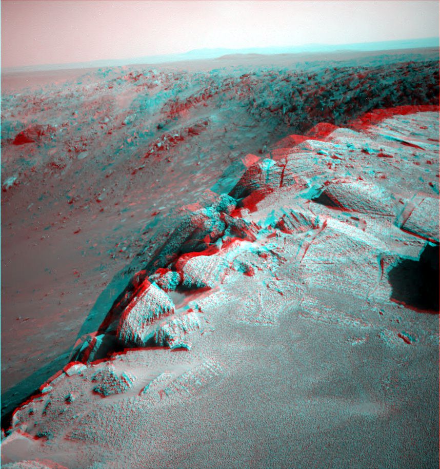
Hydrated Sulfates in 3 D at Santa Maria.
This cropped 3 D segment shows the location of the bright toned exposures of hydrated sulfate minerals detected inside the southeast rim of the steep walled crater. Deposits of hydrated sulfates are an indicator of the past flow of liquid water on Mars. They were detected from orbit by the CRISM mapping spectrometer aboard NASA’s Mars Reconnaissance Orbiter (MRO). Opportunity will go to the SE rim and try to do measurements to field verify the expected mineralogy. Credit: NASA/JPL/CornellLooking in stereo to the steep walled southern rim of Santa Maria.
Opportunity will drive to the south rim in January 2011. Cape Tribulation is in the background and located at the western rim of the huge Endeavour Crater which possesses deposits of clay minerals, or phyllosilicates, which form in the presence of neutral liquid water. Cape Tribulation is about 100 meters tall. Credit: NASA/JPL/Cornell/NickF at unmannedspaceflight.com‘Crocodile Tail’ in 3D.
Opportiunity drove past this amazing looking ejecta rock at the outskirts of Santa Maria Crater while approaching the rim. Credit: NASA/JPL/Cornell/Stu AtkinsonRover wheel tracks on Mars
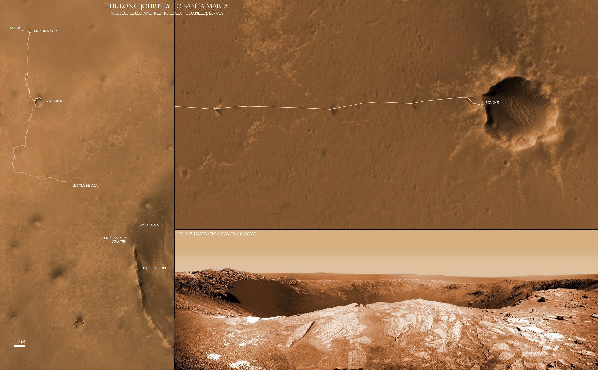
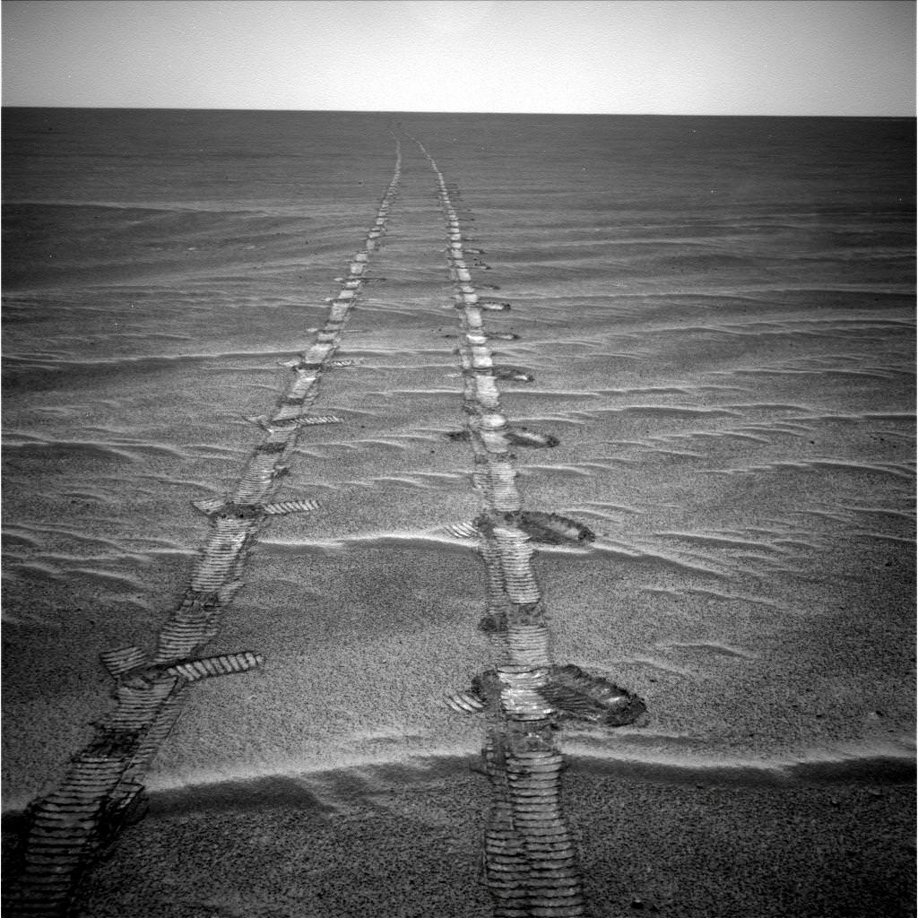
This mosaic of images from Sol 2451 (Not in 3 D) shows the tracks from Opportunity’s wheels on the approach to the steep crater rim on Sol 2450. Credit: NASA/JPL/Cornell, Marco Di Lorenzo, Ken KremerThe Long Journey to Santa Maria:
This collage of two maps and a 2 D close up panorama of Santa Maria crater (bottom right) shows the route traversed by the Opportunity Mars rover during her nearly 7 year long overland expedition across the Meridiani Planum region of Mars. Opportunity arrived at the rim of Santa Maria Crater on Dec. 16, 2010 on Sol 2451 and will drive around the edge in a counterclockwise direction to examine rocks which are indicative of the past flow of liquid water. The next destination is Endeavour Crater - some 22 km wide - to investigate water bearing minerals at Cape York and Cape Tribulation which she will reach sometime in 2011. Credit: NASA/JPL/Cornell, Marco Di Lorenzo, Ken Kremer
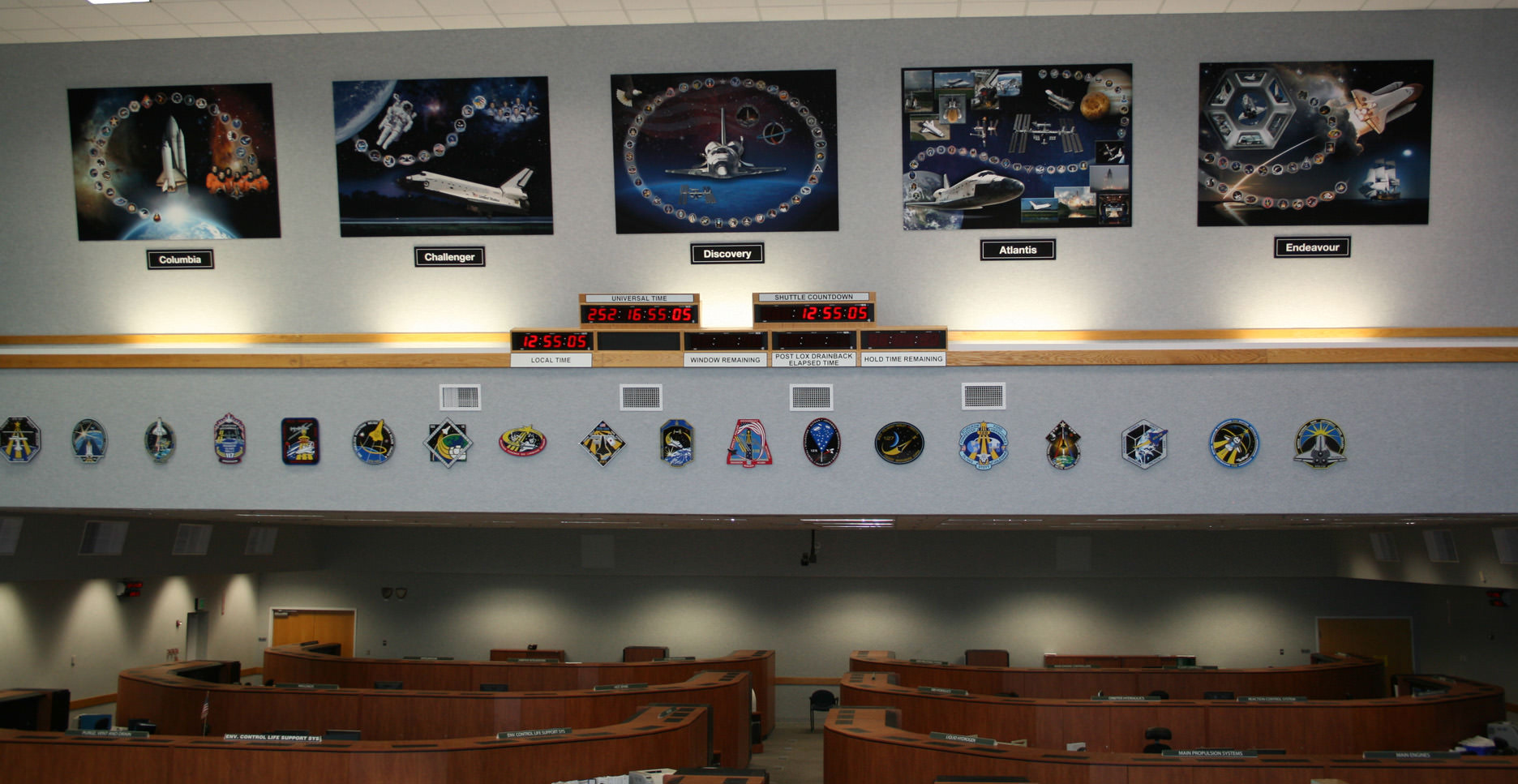
Memorial displays to all five Space Shuttle Orbiters were recently mounted inside the Space Shuttle Firing Room #4 - above the Shuttle countdown clock. These tribute displays highlight the significant achievements from the actual space voyages of the individual Orbiters launched from the Kennedy Space Center over three decades –starting with STS-1 in 1981. Credit: Ken Kremer
[/caption]
To mark the occasion of the Shuttle’s last Christmas, space shuttle worker Terry Sibile drafted a touching poem titled; “T’was the Shuttle’s Last Christmas”.
For your enjoyment Terry’s poem is reprinted below; as it appeared at Florida Today. The poem initially was circulated via email at the Kennedy Space Center (KSC) and other NASA sites across the US.
According to this article at Florida Today, Terry is a member of the engineering team dealing with cranes, platforms and doors which abound at the space center.
Only 2 or 3 flights remain before the shuttle is retired – at the peak of its performance – probably around mid-2011. NASA is still evaluating whether the budget will support flying the STS-135 mission to the International Space Station.
So it’s unlikely the shuttles will see another Christmas. Sibile’s poem thus marks another installment in the string of sad and bittersweet “lasts” for the shuttle program – “Our spirits were low … and soon we’d all go.”
The Space Shuttle Launch team at KSC recently created tribute displays to honor the achievements of all 5 Space Shuttle Orbiters and all the NASA and contractor workers involved. See photo above. Sibile’s poetry poignantly puts these displays into words.
‘Twas the Shuttle’s last Christmas by Terry Sibile
‘Twas the Shuttle’s last Christmas
and our spirits were low,
For the program was ending
and soon we’d all go.
We’d processed the Shuttles
with infinite care
And followed each mission
as if we were there.
We made every effort
to achieve all our goals;
We offered our talents,
our hearts and our souls.
Our work was much more
than a meager career;
‘Twas an honor and privilege
beyond all compare.
As this marvel of science
was applauded worldwide,
We looked on each Shuttle
with unfettered pride:
Columbia, Challenger,
Discovery, and then
Atlantis, Endeavour
all ferried brave men
And women to realms
past the confines of Earth,
Uncovering knowledge
of infinite worth.
We rejoiced with each mission’s
success, and we grieved
For the losses too painful
for us to conceive.
And over the years,
something wondrous took place:
We became kindred spirits,
united by Space.
And so, as we part,
I will bear a great loss.
And hope in the future
our paths again cross.
But until then, my friend,
this wish I confide:
Happy Christmas to all
— we had a great ride!
————————————-
Check out this 360 degree panoramic view from inside Firing Room 4 showing all five Shuttle tribute displays; recorded during my visit with Space Shuttle Launch Director Mike Leinbach. Leinbach led the effort to create the tribute displays. Courtesy of Nasatech.net
The Long Journey to Santa Maria: This collage of two maps and a new close up panorama of Santa Maria crater (bottom right) shows the route traversed by the Opportunity Mars rover during her nearly 7 year long overland expedition across the Meridiani Planum region of Mars. Opportunity arrived at the rim of Santa Maria Crater on Dec. 16, 2010 on Sol 2451. The rover has been on a crater tour since landing inside Eagle crater on Jan. 3, 2004. During her more than 26 km long journey she made numerous scientific discoveries along the way at Endurance and Victoria Craters. The rovers next destination is Endurance Crater - some 22 km wide - to investigate water bearing minerals at Cape York and Cape Tribulation which she will reach sometime in 2011. Credit: NASA/JPL/Cornell, Marco Di Lorenzo, Kenneth Kremer
[/caption]
The Opportunity rover is now sending back a plethora of awesome views of Santa Maria Crater since just arriving at the western edge of the crater on Dec. 15 (Sol 2450). This intermediate stop on the rovers 19 km long journey from Victoria Crater to giant Endeavour Crater looks to be well worth the trip and affords another fine feather in the science teams cap.
Santa Maria appears to be “relatively unweathered and fresh”, according to Ray Arvidson, of Washington University in St. Louis. Arvidson is the deputy principal investigator for the Spirit and Opportunity rovers. A bounty of boulders and rocks from the ejecta ring the rim. The crater is roughly 90 meters in diameter with an estimated depth between 9 to 14 meters. It is somewhat oval in shape, not perfectly circular.
Opportunity looks back to the long road to Santa Maria
After initially driving to a distance of about five meters from the rim on Dec. 16 (Sol 2451), Opportunity has now carefully crawled even nearer to the precipice of the craters steep cliffs. At each spot the rover snaps a series of panoramic images to document the site scientifically and esthetically and plan the next sols drive.
The team back on Earth – and millions of kilometers away – must tread with extreme caution as Opportunity creeps ever closer to the edge lest she fall off a cliff. Whereas the cameras revealed a dramatic gaping hole on Dec. 16, Opportunity is now positioned close enough to point her cameras directly at the steep walled cliffs and towards the sand dunes at the crater floor crater unveiling another stunningly gorgeous Martian vista.
Compare the panoramas from Sols 2451 and 2454 above and below as Opportunity pulled up to the rim in stages and began exploring the crater environment from different vantage points.
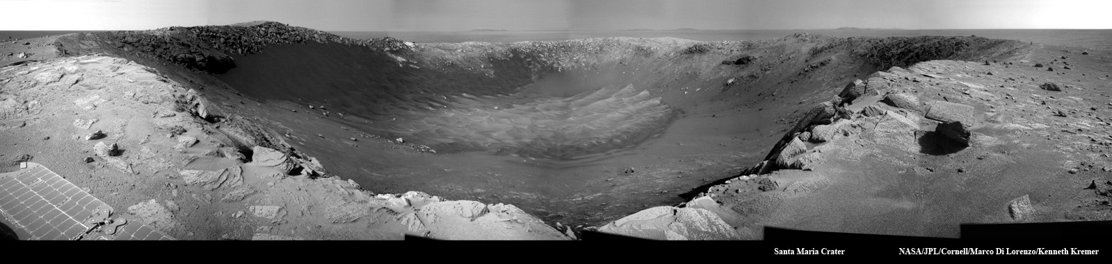
Panoramic view of Santa Maria Crater taken by Opportunity Mars rover about 5 meters from the rim on Dec 16, 2010 on Sol 2451. CRISM results suggest water bearing materials are located at the southeastern edge of the rim located roughly at the center of this image. Portions of distant Endeavour Crater are faintly visible as bumps on the horizon in the background. The northern and eastern rims are located from left to center. Cape Tribulation is to the right. Credit: NASA/JPL/Cornell, Kenneth Kremer, Marco Di LorenzoThe complete panoramic view of Santa Maria Crater taken by Opportunity Mars rover about 5 meters from the rim on Dec 16, 2010 on Sol 2451. Credit: NASA/JPL/Cornell, Jan van DrielPeering into Santa Maria Crater. Opportunity drove closer to within 5 meters of the rim and snapped this gorgeous panoramic vista unveiling the whole interior on Sols 2453 & 2354. Note the steep walls and sand dunes on the floor. Credit: NASA/JPL/Cornell, James CanvinPanoramic view revealing interior steep cliffs and sand dunes of Santa Maria Crater was taken within 5 meters of the rim on Sol 2454. Credit: NASA/JPL/Cornell, Marco Di Lorenzo, Kenneth Kremer
The rover handlers are highly adept at precisely maneuvering the 175 kg vehicle back and forth inside the danger zone at crater rims. After all Opportunity has been on a crater tour for her entire 7 year extended mission to the red planet and controllers at NASA’s Jet Propulsion Laboratory (JPL) have honed their driving techniques at countless locales both treacherous and dazzling, especially about the precipitous 50 meter cliff drops at Victoria Crater.
High priority activity on the west side of Santa Maria includes collecting the first pair in a series of long-baseline, high resolution stereo panoramas which will be used to create a digital elevation map in 3 D, according to Guy Webster, the Public Affairs Officer at NASA’s Jet Propulsion Laboratory (JPL) in Pasadena, Calif., which manages the Mars Rover mission for NASA.
The newly assembled crater maps – see the first mosaics herein – will be scrutinized and utilized for planning the best locations to visit during the upcoming multi-week science campaign. .
JPL engineers will move Opportunity in a counterclockwise direction around the rim from the Sol 2450 approach point.
“One last drive before the Christmas break will take us ~ 20m away to a lookout point, to set us up for another drive next week,” tweeted JPL Rover driver Scott Maxwell. “Last weekend’s drive around Santa Maria took us to this gorgeous new outlook. It’s grand here.”
“There are no plans to enter the crater.” Webster confirmed to me. There is no reason to take a risk when Opportunity is so close to those phyllosilicate clays at Endeavour which formed in water and have never before been directly analyzed on the Martian surface.
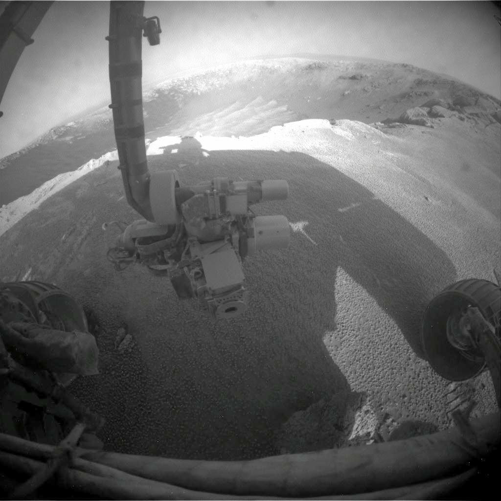
“Fisheye view of Santa Maria from the front hazcam camera with robotic arm instruments and two wheels. The RAT science drill is pointing to the left. . Credit: NASA/JPL/Cornell
The current plan calls for Opportunity to stay at Santa Maria through the upcoming Solar conjunction which starts in late January and ends in mid-February,” Webster stated.
The rover will remain stationary during that period and conduct a lengthy focused investigation of a specific spot using the instruments on the robotic arm – which include a rock drill, microscope and spectrometers.
“We will use the ‘no-new-commanding’ time of conjunction for a long-integration assessment of the composition of a selected target,” added Webster.
“The team plans to use Opportunity’s RAT- or Rock Abrasion Tool – on a target at Santa Maria,” says rover project manager John Callas of JPL. The RAT is a high tech device that uses a grinding wheel to cut into martian rocks and has performed far beyond expectation. The diamond embedded abrader teeth still have some life left, and the team wants to save some abrasion capability for the Endeavour rim targets.
Orbital Observations at Santa Maria Crater. Opportunity arrived at the western rim of Santa Maria Crater, some 90 meters wide, on Dec. 16, 2010. Researchers are using data collected by a powerful mineral mapping spectrometer (CRISM) aboard NASA’s Mars Reconnaissance Orbiter (MRO) to direct the route which Opportunity is traversing on Mars during the long term journey to Endeavour crater. Spectral observations recorded by CRISM indicates the presence of water-bearing sulfate minerals at the location shown by the red dot on the southeast rim crater whereas the crater floor at the blue dot does not. This image was taken by the High Resolution Imaging Science Experiment (HiRISE) camera also on MRO. Credit: NASA/JPL-Caltech/Univ. of Arizona


