Mars Reconnaissance Orbiter Adjusts its Orbit

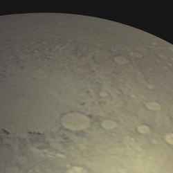
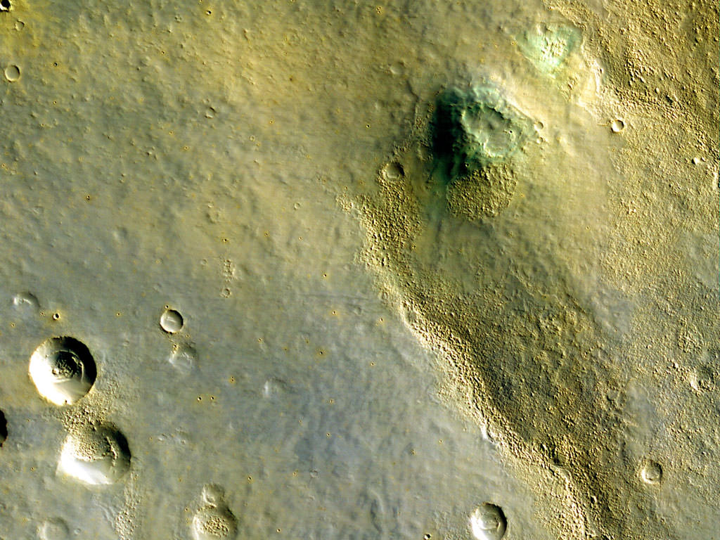
The large Argyre Basin in Mars’ southern hemisphere. Image credit: NASA/JPL/MSSS. Click to enlarge
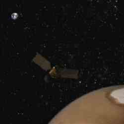
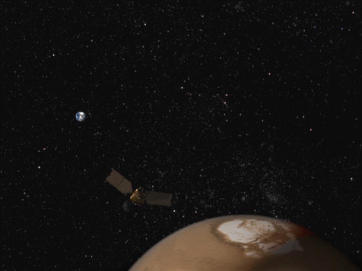
NASA’s Mars Reconnaissance Orbiter has sent back some new test images of the Martian surface, at a resolution of 2.5 metres/pixel. Once it reaches its final science orbit, the spacecraft will be 10 times closer to the planet, and the images will be even higher resolution. The spacecraft fired its thrusters on Wednesday to adjust its orbit so that it passed through Mars’ atmosphere. This maneuver is called aerobraking, and the spacecraft will make many of these passes over the next 6 months.

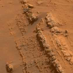
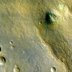
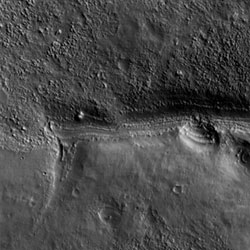
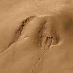
Researchers today released the first Mars images from two of the three science cameras on NASA’s Mars Reconnaissance Orbiter.

Images taken by the orbiter’s Context Camera and Mars Color Imager during the first tests of those instruments at Mars confirm the performance capability of the cameras. The test images were taken from nearly 10 times as far from the planet as the spacecraft will be once it finishes reshaping its orbit. Test images from the third camera of the science payload were released previously.

“The test images show that both cameras will meet or exceed their performance requirements once they’re in the low-altitude science orbit. We’re looking forward to that time with great anticipation,” said Dr. Michael Malin of Malin Space Science Systems, San Diego. Malin is team leader for the context camera and principal investigator for the Mars Color Imager.

The cameras took the test images two weeks after the orbiter’s March 10 arrival at Mars and before the start of “aerobraking,” a process of reshaping the orbit by using controlled contact with Mars’ atmosphere. This week, the spacecraft is dipping into Mars’ upper atmosphere as it approaches the altitude range that it will use for shrinking its orbit gradually over the next six months.

The orbiter is currently flying in very elongated loops around Mars. Each circuit lasts about 35 hours and takes the spacecraft about 27,000 miles (43,000 kilometers) away from the planet before swinging back in close.

On Wednesday, a short burn of intermediate sized thrusters while the orbiter was at the most distant point nudged the spacecraft to pass from approximately 70 miles (112 kilometers) to within 66 miles (107 kilometers) of Mars’ surface.

“This brings us well into Mars’ upper atmosphere for the drag pass and will enable the mission to start reducing the orbit to its final science altitude,” said Dan Johnston of NASA’s Jet Propulsion Laboratory, Pasadena, Calif., deputy mission manager.

After hundreds of passes through the upper atmosphere, the drag will gradually reduce the far point of the orbit until the spacecraft is in a nearly circular orbit every two hours.

After the spacecraft gets into the proper orbit for its primary science phase, the six science instruments on board will begin their systematic examination of Mars. The Mars Color Imager will view the planet’s entire atmosphere and surface every day to monitor changes in clouds, wind-blown dust, polar caps and other variable features.

Images from the Context Camera will have a resolution of 20 feet (6 meters) per pixel, allowing surface features as small as a basketball court to be discerned. The images will cover swaths 18.6 miles (30 kilometers) wide.

The Context Camera will show how smaller areas examined by the High Resolution Imaging Science Experiment Camera — which will have the best resolution ever achieved from Mars orbit — and by the mineral-identifying Compact Reconnaissance Imaging Spectrometer fit into the broader landscape. It will also allow scientists to watch for small-scale changes, such as newly cut gullies, in the broader coverage area.

The new test images from the Context Camera and the Mars Color Imager are available online at www.nasa.gov/mro , www.msss.com/mro/ctx/images/2006/04/13/ and www.msss.com/mro/marci/images/2006/04/13/ .

For more detailed information about Mars Reconnaissance Orbiter, see http://mars.jpl.nasa.gov/mro .

NASA’s Mars Reconnaissance Orbiter is managed by JPL, a division of the California Institute of Technology, Pasadena, for the NASA Science Mission Directorate, Washington. Lockheed Martin Space Systems, Denver, is the prime contractor.

Original Source: NASA News Release

Mars Rovers Head for New Sites After Studying Layers

Coarse-grained layers inside Mars’ Gusev Crater. Image credit: NASA/JPL/Cornell. Click to enlarge
NASA engineers have moved the Spirit Mars rover to a safe North-facing slope to ride out the Martian winter. Since the rover is in the Southern hemisphere, it gets much less sunlight during the Winter. This maneuver was made more difficult because its right-front wheel has stopped working – the robot is dragging it along like an anchor. Spirit requires a good angle towards the sun to catch energy from the Sun onto its solar panels. It needs to store enough electricity to run the overnight heaters that protect its electronics.

NASA’s Mars rover Spirit has reached a safe site for the Martian winter, while its twin, Opportunity, is making fast progress toward a destination of its own.

The two rovers recently set out on important — but very different — drives after earlier weeks inspecting sites with layers of Mars history. Opportunity finished examining sedimentary evidence of ancient water at a crater called “Erebus,” and is now rapidly crossing flat ground toward the scientific lure of a much larger crater, “Victoria.”

Spirit studied signs of a long-ago explosion at a bright, low plateau called “Home Plate” during February and March. Then one of its six wheels quit working, and Spirit struggled to complete a short advance to a north-facing slope for the winter. “For Spirit, the priority has been to reach a safe winter haven,” said Dr. Steve Squyres of Cornell University, Ithaca, N.Y., principal investigator for the Mars Exploration Rover project.

The rovers have operated more than eight times as long as their originally planned three-month explorations on Mars. Each has driven more than 6.8 kilometers (4.2 miles) about 11 times as far as planned. Combined, they have returned more than 150,000 images. Two years ago, the project had already confirmed that at least one place on Mars had a wet and possibly habitable environment long ago. The scientific findings continue.

Opportunity spent most of the past four months at Erebus, a highly eroded impact crater about 300 meters (1,000 feet) in diameter, where the rover found extensive exposures of thin, rippled layering interpreted as a fingerprint of flowing water. “What we see at Erebus is a thicker interval of wetted sediment than we’ve seen anywhere else,” said Dr. John Grotzinger of the California Institute of Technology, “The same outcrops also have cracks that may have formed from wetting and drying.”

In mid-March, Opportunity began a 2-kilometer (1.6-mile) trek from Erebus to Victoria, a crater about 800 meters (half a mile) across, where a thick sequence of sedimentary rocks is exposed. In the past three weeks, Opportunity has already driven more than a fourth of that distance.

At Home Plate, Spirit found coarse layering overlain by finer layering in a pattern that fits accumulation of material falling to the ground after a volcanic or impact explosion. In one place, the layers are deformed where a golfball-size rock appears to have fallen on them while they were soft. “Geologists call that a ‘bomb sag,’ and it is strong evidence for some kind of explosive origin,” Squyres said. “We would like to have had time to study Home Plate longer, but we needed to head for a north-facing slope before winter got too bad.”

Spirit is in Mars’ southern hemisphere, where the sun is crossing lower in the northern sky each day. The rovers rely on solar power. The amount available will keep dropping until the shortest days of the Mars winter, four months from now. To keep producing enough electricity to run overnight heaters that protect vital electronics, Spirit’s solar panels must be tilted toward the winter sun by driving the rover onto north-facing slopes. However, on March 13 the right-front wheel’s drive motor gave out. Spirit has subsequently driven about 80 meters (262 feet) using five wheels and dragging the sixth, but an initial route toward a large hill proved impassable due to soft ground. Last week, the team chose a smaller nearby ridge, dubbed “Low Ridge Haven,” as the winter destination. Spirit reached the ridge Sunday and has a favorable 11-degree tilt toward the north.

“We have to use care choosing the type of terrain we drive over,” Dr. Ashitey Trebi-Ollennu, a rover planner at NASA’s Jet Propulsion Laboratory, Pasadena, Calif., said about the challenge of five-wheel driving. In tests at JPL, the team has been practicing a maneuver to gain additional tilt by perching the left-front wheel on a basketball-size rock.

Spending eight months or so at Low Ridge Haven will offer time for many long-duration studies that members of the science team have been considering since early in the mission, said Dr. Ray Arvidson of Washington University in St. Louis, deputy principal investigator. These include detailed mapping of rocks and soils; in-depth determination of rock and soil composition; monitoring of clouds and other atmospheric changes; watching for subtle surface changes due to winds; and learning properties of the shallow subsurface by tracking surface-temperature changes over a span of months.

JPL, a division of the California Institute of Technology, Pasadena, manages the Mars Exploration Rover Project for the NASA Science Mission Directorate.

For images and information about the rovers, see http://www.nasa.gov/rovers or http://marsrovers.jpl.nasa.gov .

For information about NASA and agency programs on the Web, visit http://www.nasa.gov .

Original Source: NASA News Release

Mars Wants You to Have a Nice Day

This is a photograph of the unusually happy Galle Crater on Mars. ESA’s Mars Express took a series of 5 images shaped like strips which were then assembled on computer to build up a single photograph. Galle Crater is 230 km (143 miles) across, and located on the eastern rim of the Argyre Planitia impact basin on Mars.

These images, taken by the High Resolution Stereo Camera (HRSC) on board ESA’s Mars Express spacecraft, show the Galle Crater, an impact crater located on the eastern rim of the Argyre Planitia impact basin on Mars.

The HRSC obtained these images during orbits 445, 2383, 2438, 2460 and 2493 with a ground resolution ranging between 10-20 metres per pixel, depending on location within the image strip.

The images show Crater Galle lying to the east of the Argyre Planitia impact basin and south west of the Wirtz and Helmholtz craters, at 51 degrees South and 329 degrees East.

The images of the 230 km diameter impact crater are mosaics created from five individual HRSC nadir and colour strips, each tens of kilometres wide.

A large stack of layered sediments forms an outcrop in the southern part of the crater. Several parallel gullies, possible evidence for liquid water on the Martian surface, originate at the inner crater walls of the southern rim.

Crater Galle, named after the German astronomer J.G. Galle (1812-1910), is informally known as the ‘happy face’ crater.

The ‘face’ was first pointed out in images taken during NASA’s Viking Orbiter 1 mission.

***image4:left***Its interior shows a surface which is shaped by ‘aeolian’ (wind-caused) activity as seen in numerous dunes and dark dust devil tracks which removed the bright dusty surface coating.

The colour scenes, false-colour and near true-colour, have been derived from three HRSC colour and nadir channels gathered during five overlapping orbits. The perspective views have been calculated from a mosaic of digital terrain models derived from the stereo channels.

The black-and-white high-resolution image mosaic was derived from the nadir channel which provides the highest detail of all channels. The resolution has been decreased for use on the Internet, to around 50 m per pixel.

Original Source: ESA Mars Express

First Colour Images from Mars Reconnaissance Orbiter

First colour images from MRO. Image credit: NASA/JPL-Caltech/University of Arizona. Click to enlarge.
The first full colour photographs are back from NASA’s Mars Reconnaissance Orbiter, and they’re big and beautiful. The photos were actually taken in the infrared spectrum, so this isn’t what the human eye would see – the colouring was done on computer. The spacecraft was 2,493 kilometers (1,549 miles) above the surface of Mars when it captured this image. It’ll be getting much closer in the coming months, so the photos are only going to get better.

This is the first color image of Mars from the High Resolution Imaging Science Experiment on NASA’s Mars Reconnaissance Orbiter. At the center portion of the camera’s array of light detectors there are extra detectors to image in green and near-infrared color bandpasses, to be combined with the black-and-white images (from red-bandpass detectors) to create color images. This is not natural color as seen by human eyes, but infrared color — shifted to longer wavelengths. This image also has been processed to enhance subtle color variations. The southern half of the scene is brighter and bluer than the northern half, perhaps due to early-morning fog in the atmosphere. Large-scale streaks in the northern half are due to the action of wind on surface materials. The blankets of material ejected from the many small fresh craters are generally brighter and redder than the surrounding surface, but a few are darker and less red. Two greenish spots in the middle right of the scene may have an unusual composition, and are good future targets for the Compact Reconnaissance Imaging Spectrometer for Mars, a mineral-identifying instrument on Mars Reconnaissance Orbiter ( http://crism.jhuapl.edu/). In the bottom half of the image we see a redder color in the rough areas, where wind and sublimation of water or carbon dioxide ice have partially eroded patches of smooth-textured deposits.

This image was taken by HiRISE on March 24, 2006. The image is centered at 33.65 degrees south latitude, 305.07 degrees east longitude. It is oriented such that north is 7 degrees to the left of up. The range to the target was 2,493 kilometers (1,549 miles). At this distance the image scale is 2.49 meters (8.17 feet) per pixel, so objects as small as 7.5 meters (24.6 feet) are resolved. In total this image is 49.92 kilometers (31.02 miles) or 20,081 pixels wide and 23.66 kilometers (14.70 miles) or 9,523 pixels long. The image was taken at a local Mars time of 07:33 and the scene is illuminated from the upper right with a solar incidence angle of 78 degrees, thus the sun was 12 degrees above the horizon. At an Ls of 29 degrees (with Ls an indicator of Mars’ position in its orbit around the sun), the season on Mars is southern autumn.

Images from the High Resolution Imaging Science Experiment and additional information about the Mars Reconnaissance Orbiter are available online at: http://www.nasa.gov/mro or http://HiRISE.lpl.arizona.edu. For information about NASA and agency programs on the Web, visit: http://www.nasa.gov.

JPL, a division of the California Institute of Technology in Pasadena, manages the Mars Reconnaissance Orbiter for NASA’s Science Mission Directorate, Washington. Lockheed Martin Space Systems is the prime contractor for the project and built the spacecraft. The HiRISE camera was built by Ball Aerospace and Technology Corporation and is operated by the University of Arizona.

Original Source: NASA/JPL News Release

Mars Aerobraking Begins

Image showing the heat being emitted from the day and night side of Mars. Image credit: NASA Click to enlarge
Now firmly in orbit around the Red Planet, NASA’s Mars Reconnaissance Orbiter has begun a series of maneuvers through the atmosphere to slow itself down even further. The process is called aerobraking, and each successive pass slows it down a little bit, lowering its orbit. After 6 months of aerobraking, sweeping through the atmosphere 550 times, the spacecraft will be in its final science orbit.

NASA’s Mars Reconnaissance Orbiter yesterday began a crucial six-month campaign to gradually shrink its orbit into the best geometry for the mission’s science work.

Three weeks after successfully entering orbit around Mars, the spacecraft is in a phase called “aerobraking.” This process uses friction with the tenuous upper atmosphere to transform a very elongated 35-hour orbit to the nearly circular two-hour orbit needed for the mission’s science observations.

The orbiter has been flying about 426 kilometers (265 miles) above Mars’ surface at the nearest point of each loop since March 10, then swinging more than 43,000 kilometers (27,000 miles) away before heading in again. While preparing for aerobraking, the flight team tested several instruments, obtaining the orbiter’s first Mars pictures and demonstrating the ability of its Mars Climate Sounder instrument to track the atmosphere’s dust, water vapor and temperatures.

On Thursday, Mars Reconnaissance Orbiter fired its intermediate thrusters for 58 seconds at the far point of the orbit. That maneuver lowered its altitude to 333 kilometers (207 miles) when the spacecraft next passed the near point of its orbit, at 6:46 a.m. Pacific time today (9:46 a.m. Eastern Time).

“We’re not low enough to touch Mars’ atmosphere yet, but we’ll get to that point next week,” said Dr. Daniel Kubitschek of NASA’s Jet Propulsion Laboratory, Pasadena, Calif., deputy leader for the aerobraking phase of the mission.

The phase includes about 550 dips into the atmosphere, each carefully planned for the desired amount of braking. At first, the dips will be more than 30 hours apart. By August, there will be four per day.

“We have to be sure we don’t dive too deep, because that could overheat parts of the orbiter,” Kubitschek said. “The biggest challenge is the variability of the atmosphere.”

Readings from accelerometers during the passes through the atmosphere are one way the spacecraft can provide information about upward swelling of the atmosphere due to heating.

The Mars Climate Sounder instrument also has the capability to monitor changes in temperature that would affect the atmosphere’s thickness. “We demonstrated that we’re ready to support aerobraking, should we be needed,” JPL’s Dr. Daniel McCleese, principal investigator for the Mars Climate Sounder, said of new test observations.

Infrared-sensing instruments and cameras on two other Mars orbiters are expected to be the main sources of information to the advisory team of atmospheric scientists providing day-to-day assistance to the aerobraking navigators and engineers. “There is risk every time we enter the atmosphere, and we are fortunate to have Mars Global Surveyor and Mars Odyssey with their daily global coverage helping us watch for changes that could increase the risk,” said JPL’s Jim Graf, project manager for the Mars Reconnaissance Orbiter.

Using aerobraking to get the spacecraft’s orbit to the desired shape, instead of doing the whole job with thruster firings, reduces how much fuel a spacecraft needs to carry when launched from Earth. “It allows you to fly more science payload to Mars instead of more fuel,” Kubitschek said.

Once in its science orbit, Mars Reconnaissance Orbiter will return more data about the planet than all previous Mars missions combined. The data will help researchers decipher the processes of change on the planet. It will also aid future missions to the surface of Mars by examining potential landing sites and providing a high-data-rate communications relay.

Test observations from the Mars Climate Sounder, other images and additional information about Mars Reconnaissance Orbiter are available online at http://www.nasa.gov/mro and at http://marsprogram.jpl.nasa.gov/mro .

For information about NASA and agency programs on the Web, visit http://www.nasa.gov .

Original Source: NASA News Release

Libya Montes Valley on Mars

ESA’s Mars Express took this photograph of Libya Montes, which is south of the large Isidis Planitia impact basin on Mars. The region contains a 400 km (248 mile) long valley that was carved into the early Martian surface; probably by water when the planet was warm and wet. Scientists estimate that the same amount of water was probably flowing out of the region as middle reaches of the Mississippi river in the US.

These images, taken by the High Resolution Stereo Camera (HRSC) on board ESA’s Mars Express spacecraft, show the region of Libya Montes, south of the Isidis Planitia impact basin on Mars.

The HRSC obtained these images during orbit 922 with a ground resolution of approximately 14.3 metres per pixel at equatorial latitudes near longitude 81 degrees East.

The images show the central reaches of a 400-kilometre long valley that was carved into the surface in early Martian history, approximately 3500 million years ago.

The central parts of the broad valley show traces of an interior valley, documenting the flow of water that once occurred on the surface of the planet during periods of wetter climate.

Determinations of discharge volumes on the basis of high-resolution HRSC derived digital terrain models reveal discharge rates that are comparable to those of the middle reaches of the Mississippi river in the USA.

On the basis of crater-size frequency distributions on the valley floor and surrounding terrain it has been shown that the formation time of the valley amounts to approximately 350 million years.

Measurements of erosion rates suggest that the active phases of valley development are characterised by short periods of intense fluvial activity rather than sustained liquid flow.

Details on valley formation have been published by R. Jaumann (DLR) and colleagues, as an article ‘Constraints on fluvial erosion by measurements of the Mars Express High Resolution Stereo Camera’ in Geophysical Research Letters, 32, L16203, doi:10.1029/2005GL023415).

***image4:right***The colour scenes were derived from the three HRSC colour channels and the nadir channel. The perspective views have been calculated from the digital terrain model derived from the stereo channels.

The 3D anaglyph image was calculated from the nadir and one stereo channel. The black and white high-resolution images were derived from the nadir channel that provides the highest detail of all the channels.

Original Source: ESA Mars Express

First Photo from Mars Reconnaissance Orbiter

A portion of the first full-resolution image returned by MRO. Image credit: NASA/JPL. Click to enlarge.
After years of development and months of spaceflight, NASA’s Mars Reconnaissance Orbiter is beginning to return photos of the Red Planet. The spacecraft pointed three of its cameras at the surface of Mars on Thursday, and started snapping pictures. This photo was taken when the spacecraft was at an altitude of 2,489 kilometers (1,547 miles), which is about 9 times as high as its final orbit – the pictures are going to just get better. Even so, the resolution at this altitude is about the same as the best pictures returned by other Mars orbiters.

The first test images of Mars from NASA’s newest spacecraft provide a tantalizing preview of what the orbiter will reveal when its main science mission begins next fall.

Three cameras on NASA’s Mars Reconnaissance Orbiter were pointed at Mars at 8:36 p.m. PST Thursday, while the spacecraft collected 40 minutes of engineering test data. The cameras are the High Resolution Imaging Science Experiment, the Context Camera and the Mars Color Imager.

“These high-resolution images of Mars are thrilling, and unique given the early morning time-of-day. The final orbit of Mars Reconnaissance Orbiter will be over Mars in the mid-afternoon, like Mars Global Surveyor and Mars Odyssey,” said Alfred McEwen, University of Arizona, Tucson, principal investigator for the orbiter’s High Resolution Imaging Science Experiment camera.

“These images provide the first opportunity to test camera settings and the spacecraft’s ability to point the camera with Mars filling the instruments’ field of view,” said Steve Saunders, the mission’s program scientist at NASA Headquarters. “The information learned will be used to prepare for the primary mission next fall.” The main purpose of these images is to enable the camera team to develop calibration and image-processing procedures such as the precise corrections needed for color imaging and for high-resolution surface measurements from stereo pairs of images.

To get desired groundspeeds and lighting conditions for the test images, researchers programmed the cameras to shoot while the spacecraft was flying about 2,489 kilometers (1,547 miles) or more above Mars’ surface, about nine times the range planned for the orbiter’s primary science mission. Even so, the highest resolution of about 2.5 meters (8 feet) per pixel – an object 8 feet in diameter would appear as a dot — is comparable to some of the best resolution previously achieved from Mars orbit.

Further processing of the images during the next week or two is expected to combine narrow swaths into broader views and show color in some portions.

The Mars Reconnaissance Orbiter has been flying in elongated orbits around Mars since it entered orbit on March 10. Every 35 hours, it has swung about 44,000 kilometers (27,000 miles) away from the planet then come back within about 425 kilometers (264 miles) of Mars’ surface.

Mission operations teams at NASA’s Jet Propulsion Laboratory, Pasadena, Calif, and at Lockheed Martin Space Systems, Denver, continue preparing for aerobraking. That process will use about 550 careful dips into the atmosphere during the next seven months to shrink the orbit to a near-circular shape less than 300 kilometers (200 miles) above the ground.

More than 25 gigabits of imaging data, enough to nearly fill five CD-ROMs, were received through NASA’s Deep Space Network station at Canberra, Australia, and sent to JPL. They were made available to the camera teams at the University of Arizona Lunar and Planetary Laboratory and Malin Space Science Systems, San Diego, Calif.

Preliminary images from the High Resolution Imaging Science Experiment and additional information about the Mars Reconnaissance Orbiter are available online at: http://www.nasa.gov/mro or http://HiRISE.lpl.arizona.edu

Additional processing has begun for release of other images from the test in coming days.

For information about NASA and agency programs on the Web, visit: http://www.nasa.gov

JPL, a division of the California Institute of Technology in Pasadena, manages the Mars Reconnaissance Orbiter for NASA’s Science Mission Directorate, Washington. Lockheed Martin Space Systems is the prime contractor for the project and built the spacecraft.

Original Source: NASA/JPL News Release

Debris Filled Craters on Mars

This photograph was taken by ESA’s Mars Express spacecraft. It shows a mountain in the eastern Hellas Planitia region with craters partly filled with debris. It’s possible that the mountain was covered by glaciers in the past, which filled up the craters with ice and debris; the debris remained after the glaciers retreated. The craters are largely free of meteorite impacts inside, so it’s believed they filled with debris less than a few million years ago.

This video and accompanying images, taken by the High Resolution Stereo Camera (HRSC) on board ESA’s Mars Express spacecraft, show an unusual flow deposit on the floors of two adjacent impact craters in the eastern Hellas Planitia region, indicating possible glacial processes.

The stereo capability of the HRSC makes it possible to animate 3D anaglyph images, based on digital elevation models. The image data have been acquired during Mars Express orbit 451 from an altitude of 590 kilometres with an original resolution of 29 metres per pixel.

The unusual ‘hourglass’-shaped structure is located in the southern-hemisphere highland terrain of Promethei Terra at the eastern rim of the Hellas Basin, at about latitude 38 South and longitude 104 East.

Most likely the surface morphology is formed by the ‘creep’ of ice and debris, similar to either terrestrial rock glacier landforms or debris covered glaciers which are commonly found in high latitudes and alpine regions.

‘Talus’ material (or ‘scree’, the broken rocks that lie on a steep mountainside or at the base of a cliff) and ice-rich debris accumulated at the base of the remnant massif and filled the upper bowl-shaped impact crater which is approximately nine kilometres wide. The debris-ice mixture then flowed through a breach in the crater rim into a 17-kilometre wide crater, 500 metres below, taking advantage of the downward slope.***image4:left***

Of particular interest is the age of these surfaces, which seem to be fairly intact over a wide area. It has been shown recently that there is some evidence that glaciers were shaping the Martian surface at mid latitudes and even near the equator until a few million years ago.

Typical evidence for a significant loss of volatiles, such as pits and other depressions can be observed on all debris surfaces surrounding the remnant massif.

The statistical analysis of the number of craters formed by meteorite impacts used for age determination also shows that part of the surface with its present-day glacial characteristics was formed only a few million years ago.

Original Source: Mars Express

Maybe Water Didn’t Make the Gullies on Mars

Mars gullies in Noachis Terra region. Image credit: NASA Click to enlarge
It was only a few years that researchers announced the discovery of gullies on Mars. Here on Earth, gullies like this are formed when water flows quickly down a hill, and erodes the soil. Unfortunately, there might be another explanation for the Martian version – since similar gullies have now been seen on the Moon as well. It’s possible that the gullies are formed completely dry, when micrometeorites strike the side of a crater wall and trigger a landslide.

If you’re a scientist studying the surface of Mars, few discoveries could be more exciting than seeing recent gullies apparently formed by running water.

And that’s what scientists believed they saw in Mars Orbital Camera (MOC) images five years ago. They published a paper in Science on MOC images that show small, geologically young ravines. They concluded that the gullies are evidence that liquid water flowed on Mars’ surface sometime within the last million years.

A word of caution, though: The moon has gullies that look like that, a University of Arizona Lunar and Planetary Laboratory researcher has found. And water certainly didn’t form gullies on the waterless moon.

Gwendolyn D. Bart is presenting the work today at the 37th Lunar and Planetary Science Conference in Houston.

“We’d all like to find liquid water on Mars,” Bart said. “That would be really, really exciting. If there were liquid water on Mars, humans wouldn’t have to ship water from Earth when they go to explore the planet. That would be an enormous cost savings. And liquid water near the surface of Mars would greatly increase the chances for native life on Mars.”

The 2000 Science paper was provocative, Bart said. “But I was skeptical. I wondered if there is another explanation for the gullies.”

Then last year she heard a talk by Allan Treiman of the Lunar and Planetary Institute. Treiman suggested the martian gullies might be dry landslides, perhaps formed by wind and not formed by water at all.

Recently, Bart was studying the lunar landscape in high-resolution images taken in 1969, prior to the Apollo landings, for her research on processes that modify the lunar surface.

“Totally by accident, I saw gullies that looked strikingly like the gullies on Mars,” she said.

“If the dry landslide hypothesis for the formation of martian gullies is correct, we might expect to see similar features on the moon, where there is no water,” she said. “We do.”

Gullies in the moon’s 10-mile-diameter (17 kilometer) crater Dawes are similar in structure and size to those in a martian crater that MOC photographed. Micrometeorites hitting the smooth slopes and crater on the airless moon could easily trigger small avalanches that form gullies, Bart said.

However, the martian gullies also resemble gullies on Earth that were formed by water, she noted.

“My point is that you can’t just look at the Mars gullies and assume they were formed by water. It may be, or may be not. We need another test to know.”

Original Source: UA News Release

Mars Orbiter Survives Its Journey to the Red Planet

Artist’s concept of MRO in orbit at Mars. Image credit: NASA/JPL Click to enlarge
Data transmitted back to Earth by NASA’s Mars Reconnaissance Orbiter indicates that the spacecraft successfully inserted itself into orbit around the Red Planet. It fired its main thrusters long enough to slow down its speed so Mars could capture it a wide orbit. The spacecraft will spend the next half-year aerobraking to lower down into a nearly circular orbit. Its instruments will be capable of resolving the Martian surface better than any spacecraft currently orbiting Mars.

With a crucially timed firing of its main engines today, NASA’s new mission to Mars successfully put itself into orbit around the red planet.

The spacecraft, Mars Reconnaissance Orbiter, will provide more science data than all previous Mars missions combined.

Signals received from the spacecraft at 2:16 p.m. Pacific Time after it emerged from its first pass behind Mars set off cheers and applause in control rooms at NASA’s Jet Propulsion Laboratory, Pasadena, Calif., and at Lockheed Martin Space Systems, Denver.

“This is a great milestone to have accomplished, but it’s just one of many milestones before we can open the champagne,” said Colleen Hartman, deputy associate administrator for NASA’s Science Mission Directorate. “Once we are in the prime science orbit, the spacecraft will perform observations of the atmosphere, surface, and subsurface of Mars in unprecedented detail.”

The spacecraft traveled about 500 million kilometers (310 million miles) to reach Mars after its launch from Florida on Aug. 12, 2005. It needed to use its main thrusters as it neared the planet in order to slow itself enough for Mars’ gravity to capture it. The thruster firing began while the spacecraft was still in radio contact with Earth, but needed to end during a tense half hour of radio silence while the spacecraft flew behind Mars.

“Our spacecraft has finally become an orbiter,” said JPL’s Jim Graf, project manager for the mission. “The celebration feels great, but it will be very brief because before we start our main science phase, we still have six months of challenging work to adjust the orbit to the right size and shape.”

For the next half-year, the mission will use hundreds of carefully calculated dips into Mars’ atmosphere in a process called “aerobraking.” This will shrink its orbit from the elongated ellipse it is now flying, to a nearly circular two-hour orbit. For the mission’s principal science phase, scheduled to begin in November, the desired orbit is a nearly circular loop ranging from 320 kilometers (199 miles) to 255 kilometers (158 miles) in altitude, lower than any previous Mars orbiter. To go directly into such an orbit instead of using aerobraking, the mission would have needed to carry about 70 percent more fuel when it launched.

The instruments on Mars Reconnaissance Orbiter will examine the planet from this low-altitude orbit. A spectrometer will map water-related minerals in patches as small as a baseball infield. A radar instrument will probe for underground layers of rock and water. One telescopic camera will resolve features as small as a card table. Another will put the highest-resolution images into broader context. A color camera will monitor the entire planet daily for changes in weather. A radiometer will check each layer of the atmosphere for variations in temperature, water vapor and dust.

“The missions currently at Mars have each advanced what we know about the presence and history of water on Mars, and one of the main goals for Mars Reconnaissance Orbiter is to decipher when water was on the surface and where it is now,” said JPL’s Dr. Richard Zurek, project scientist for the mission. “Water is essential for life, so that will help focus future studies of whether Mars has ever supported life.”

The orbiter can radio data to Earth at up to 10 times the rate of any previous Mars mission. Besides sending home the pictures and other information from its own investigations, it will relay data from surface missions, including NASA’s Phoenix Mars Scout scheduled for launch in 2007 and Mars Science Laboratory in development for 2009.

Additional information about Mars Reconnaissance Orbiter is available online at:

http://www.nasa.gov/mro

The mission is managed by JPL, a division of the California Institute of Technology, Pasadena, for the NASA Science Mission Directorate, Washington. Lockheed Martin Space Systems, Denver, is the prime contractor for the project and built the spacecraft.

Original Source: NASA News Release