Ausonia Mensa Massif on Mars

Perspective view of the Ausonia Mensa massif. Image credit: ESA Click to enlarge
These images, taken by the High Resolution Stereo Camera (HRSC) on board ESA’s Mars Express spacecraft, show the Ausonia Mensa massif on Mars.

The HRSC obtained these images during orbit 506 with a ground resolution of approximately 37.6 metres per pixel. The scenes show the region of Hesperia Planum, containing the massif, at approximately 30.3 South and 97.8 East. North is to the right in these images.

Ausonia Mensa is a large remnant mountain with several impact craters, rising above basaltic sheet layers. The mountain stretches over an area of about 98 kilometres by 48 kilometres and has an elevation of 3700 metres.

A large crater, approximately 7.5 kilometres in diameter and 870 metres deep, has been partially filled with sediment. The northern flank of the crater is broken by a large gully caused by erosion.

Numerous branched channels, also resulting from erosion, run along the edge of top of the plateau toward the plains at the foot of the mountain.

The western flank of the mountain is dominated by a large crater, about six kilometres in diameter, which clearly shows an ejecta blanket and secondary cratering.

Aeolian, or ‘wind-created’, structures are visible about 50 kilometres to south-east of the massif, indicating channeling of atmospheric flow. They are clearly visible because of their different colour.

***image4:left***A heavily eroded, partially filled crater of approximately six kilometres diameter is visible to the north of the massif. The crater is characterised by numerous, smaller and younger craters.

The colour scenes have been derived from the three HRSC-colour channels and the nadir channel.

The perspective views have been calculated from the digital terrain model derived from the stereo channels.

The 3D anaglyph image was calculated from the nadir and one stereo channel.

Original Source: ESA Portal

Solar Flares Altered Mars’ Atmosphere

Solar flare. Image credit: ESA Click to enlarge
Boston University astronomers announced today the first clear evidence that solar flares change the upper atmosphere of Mars. In an article published in the February 24th issue of the journal Science, the researchers describe how X-ray bursts from the Sun in April 2001 recorded by satellites near Earth reached Mars and caused dramatic enhancements to the planet’s ionosphere ??bf? the region of a planet’s atmosphere where the Sun’s ultraviolet and X-rays are absorbed by atoms and molecules. The measurements were made by the Mars Global Surveyor (MGS) spacecraft at the Red Planet as it transmitted signals to NASA’s antenna sites back on Earth.

“On April 15th and 26th of 2001, radio signals from MGS showed that the Martian ionosphere was unusually dense, and this was the clue that some extra production of ions and electrons had occurred,” explained Michael Mendillo, professor of astronomy, who led the BU research team in its Center for Space Physics.

“At Earth, the GOES satellites measure the Sun’s X-rays almost continuously,” said Dr. Paul Withers of BU. “Our search of their large database discovered several cases of flares occurring just minutes before MGS detected enhancements in Mars’ ionosphere.”

The extra electrons produced by the Sun’s X-rays cause subtle changes in how the MGS radio waves travel toward Earth. Therefore, the team wanted to find several unambiguous case study events before announcing their findings.

The Radio Science Experiment on MGS has made observations of Mars’ ionosphere since its arrival there in late 1999. Its radio transmissions are received by NASA and then cast into scientifically meaningful data by Dr. David Hinson at Stanford University who provides open access to researchers worldwide via a Web site. “We needed Dr. Hinson’s expert advice to make sure that some odd changes in the MGS radio signal had not occurred just by chance,” Dr. Withers added.

To confirm that the photons from these flares had sufficient fluxes to actually modify an ionosphere, additional evidence was sought using measurements on Earth. “During this period, the Sun, Earth and Mars were nearly in a straight line and thus the X-rays measured at Earth should have caused enhancements here as well as at Mars,” Mendillo added.

Using several ionospheric radars spread over the globe, operated by scientists at the University of Massachusetts/Lowell, Professor Bodo Reinisch confirmed that the Sun’s X-rays caused equally impressive modifications to Earth’s ionosphere at the precise times required on those days.

“The science yield from this work will be in the new field of Comparative Atmospheres,” Mendillo pointed out. “By that I mean studies of the same process in nature, in this case making an ionosphere on two planets simultaneously, offer insights and constraints to models not always possible when studying that process on a single planet. The fifth member of our team, Professor Henry Rishbeth of the University of Southampton in England, provides the expertise in theory and modeling that will be the focus of our follow-up studies.”

Founded in 1839, Boston University is an internationally recognized institution of higher education and research. With more than 30,000 students, it is the fourth largest independent university in the United States. BU contains 17 colleges and schools along with a number of multi-disciplinary centers and institutes which are central to the school’s research and teaching mission.

Original Source: Boston University

The Shadow of Phobos

Black and white view of Phobos’s shadow. Image credit: ESA Click to enlarge
This image, taken by the High Resolution Stereo Camera (HRSC) on board ESA’s Mars Express spacecraft, shows the fast-moving shadow of the moon Phobos as it moved across the Martian surface.

The HRSC obtained this unique image during orbit 2345 on 10 November 2005. These observations would not have been possible without the close co-operation between the camera team at the Institute of Planetary Research at DLR and the ESA teams, in particular the mission engineers at ESA’s European Space Operations Centre (ESOC) in Darmstadt, Germany.

They confirm the model of the moon’s orbit around Mars, as it was determined earlier in 2004 also on the basis of HRSC images. They also show that with accurate planning even moving objects can be captured exactly at their predicted position.

The basis for such observations is the accurate knowledge of the spacecraft position in its orbit as well as of the targeted location on Mars to within a few hundred metres.

Phobos is the larger of the two Martian moons, 27 kilometres by 22 kilometres in size, and travels around Mars in an almost circular orbit at an altitude of about 6000 kilometres. Phobos takes slightly more than 7.5 hours to complete a full revolution around the planet.

When it is between the Sun and Mars, Phobos casts a small and diffuse shadow onto the Martian surface. To an observer on Mars, this would appear as a very quick eclipse of the Sun. This is similar to an eclipse on Earth, when the Moon covers the solar disk but much slower.

The shadow of Phobos has an elliptical shape on the Martian surface, because the shadow’s cone hits the surface at an oblique angle. This shadow appears to be distorted even more because of the imaging technique of the HRSC.

The shadow moves across the surface with a speed of roughly 7200 kilometres per hour from west to east. The spacecraft travels with a higher speed of about 12 600 kilometres per hour on its almost polar orbit from south to north.

Since HRSC scans the surface synchronised with the flight velocity of Mars Express, it takes some time to cover the shadow in its full dimension. Within this short time, however, the moon moves on, and therefore the shape of its shadow is ‘smeared’ in the HRSC image.

Another phenomenon, that the shadow is darker at its centre than the edges, can be explained by again imagining the observer on Mars. With its small size, Phobos would only cover some 20% of the solar disk.

Even if the observer stood in the centre of the shadow, they would still be illuminated by the uncovered part of the Sun’s disk, in a partial solar eclipse instead of a total eclipse.

Members of the HRSC Science Team recalculated the orbit of Phobos on the basis of images taken in 2004. With the help of the improved orbit determination ? the moon has advanced about 12 kilometres with respect to its previously predicted position along its orbit ? it was possible to calculate those precise times when the shadow observations could be made. In turn, it was possible to verify the accuracy of the improved orbit determination by the shadow’s position in the new images.

Original Source: ESA Portal

Mars Express Finds Auroras on Mars

An artist’s illustration of aurorae on night-side of Mars. Image credit: M. Holmstrom (IRF) Click to enlarge
ESA’s Mars Express spacecraft has seen more evidence that aurorae occur over the night side of Mars, especially over areas of the surface where variations in the magnetic properties of the crust have been detected.

Observations from the ASPERA instrument on board ESA’s Mars Express spacecraft show structures (inverted-V features) of accelerated electrons and ions above the night side of Mars that are almost identical to those that occur above aurorae on Earth.

Aurorae are spectacular displays often seen at the highest latitudes on Earth. On our planet, as well as on the giant planets Jupiter, Saturn, Uranus and Neptune, they occur at the foot of the planetary magnetic field lines near the poles, and are produced by charged particles ? electrons, protons or ions ? precipitating along these lines.

“Aurorae are created when energetic charged particles collide with the upper atmosphere,” says Rickard Lundin, Principal Investigator for ASPERA, from the Swedish Institute of Space Physics Physics (IRF), Kiruna, Sweden.

“When they are decelerated, energy is released that causes emissions of light – aurorae. During strong aurorae the precipitating particles are accelerated and gain energy, leading to more intense light,” said Lundin.

The scientists have found that the energy flux of the precipitating particles is large enough that it would lead to aurorae comparable to those of weak or medium intensity at Earth.

“Mars lacks a strong intrinsic magnetic or dipole field, and therefore we have not had reason to believe that aurorae occur there,” said Lundin.

A few years ago it was suggested that auroral phenomena could exist on Mars too. This hypothesis was reinforced by the Mars Global Surveyor discovery of ‘crustal magnetic anomalies’, most likely the remnants of an old planetary magnetic field.

This discovery started speculation that auroras could also occur at Mars. In 2004, the SPICAM instrument on board Mars Express observed emissions of light during a magnetic anomalies investigation – emissions that could be due to precipitating energetic particles.

The ASPERA scientists have now found that the structures of accelerated particles are indeed associated with the ‘crustal magnetic anomalies’ at Mars, but that strong acceleration mainly occurs in a region close to local midnight.

The precise emissions of light that occur remain to be studied since the composition of the upper atmosphere on the night side is not well known. On the basis of atmospheric models, the scientists speculate that the classical ‘green’ emission line of oxygen might be present.

“But, as we see Mars as always sunlit, the aurorae on the night side of Mars cannot be observed from Earth,” added Lundin.

Original Source: ESA Portal

Dig a Big Hole on Mars to Search for Life

THOR will search for water ice in potentially habitable zones. Image credit: NASA Click to enlarge
A proposed new robotic mission to Mars plans to make the first exploration of subsurface water ice in a potentially habitable zone.

If approved, the Tracing Habitability, Organics and Resources (THOR) project ? a low-cost mission designed for NASA’s Mars Scout program ? aims to send a projectile at high speed into the Martian surface while observing the impact and its aftermath. The mission would be led by ASU, in partnership with the Jet Propulsion Laboratory (JPL).

The THOR mission, planned for launch in 2011, aims to use a direct approach to excavating material from beneath the surface of Mars: blasting it out.

“The mission’s goal is to expose snow and ice in a previously unexplored part of Mars: the deep subsurface,” says THOR’s principal investigator, Phil Christensen of ASU’s Mars Space Flight Facility. “We’ll do this by blowing a crater at least 30 feet deep in the Martian ground.”

Besides finding underground water, he says, THOR also proposes to look for organic compounds, including methane, which Earth-based telescopes and other Mars spacecraft have detected in the Martian atmosphere.

The mission aims to use a two-part spacecraft, which consists of an “impactor” probe and an observer craft. The impactor is a simple projectile made of pure Arizona copper. The observer spacecraft will carry it until shortly before reaching Mars. After being released from the observer, the impactor will streak through the Martian atmosphere to an impact site lying between 30 degrees and 60 degrees latitude, in either the northern or southern hemisphere of the Red Planet.

“In many areas of Mars’ middle latitudes, we see tantalizing evidence of dust-covered layers of snow or ice,” Christensen says. “THOR will aim for this material.”

The suspected ice-rich layers were deposited during the past 50,000 to 1 million years, as the Martian climate changed because of orbital variations.

According to the mission plan, when the impactor slams into the ground, it will dig a crater more than 30 feet (10 meters) deep. The observer spacecraft will study the debris plume jetting from the impact site.

The observer’s instruments will include a visible-light camera and an infrared spectrometer. In addition to studying the plume, the spectrometer’s role is to search the Martian atmosphere for organic materials and gases, such as methane.

In the past, Christensen notes, Mars has been studied using fly-by and orbiter spacecraft, and with landers. While highly valuable, such missions have only scratched the surface, he says.

“The time has come to take Martian studies a step further ? and deeper,” Christensen says. “This unexplored region of Mars may provide chemical and mineral clues to tell us about habitable areas on the planet.”

“The THOR mission plans to use a straightforward, low-risk approach to reach the Martian subsurface,” says JPL’s David Spencer, the study lead engineer for THOR.

Spencer is the former mission manager for Deep Impact, the comet mission that pioneered the impact technique.

In comparing the two missions, Spencer says, “With such a large target region on Mars, delivering THOR’s impactor will be less challenging than the Deep Impact comet encounter.”

Christensen sees THOR’s scientific value continuing far beyond the impact.

“THOR’s crater will remain a test-site for all current Mars spacecraft and those in years to come,” he says. “The crater might also be visited on the ground by a future Mars rover, sometime in the next decade.”

NASA’s Mars Scouts are competitively proposed missions designed to advance the goals of NASA’s Mars exploration program. The Mars Scout Program is managed by JPL for NASA’s Office of Space Science, based in Washington.

Original Source: ASU News Release

Channels and Pits on Mars

Perspective view of Phlegethon Catena. Image credit: ESA Click to enlarge
This image, taken by the High Resolution Stereo Camera (HRSC) on board ESA’s Mars Express spacecraft, show pits and tectonic ‘grabens’ in the Phlegethon Catena region of Mars.

The HRSC obtained this image during orbit 1217 with a ground resolution of approximately 11.9 metres per pixel. The scene shows the region of Phlegethon Catena, centred at approximately 33.9? South and 253.1? East.

Located south-east of the Alba Patera volcano, Phlegethon Catena is a region exhibiting a high density of tectonic grabens, which are blocks of terrain that have dropped relative to their surroundings as a result of a geological extension of the crust.

In the colour image, this swarm of grabens trends roughly north-east to south-west, with individual widths ranging from approximately one half to ten kilometres.

The series of closely spaced depressions that exhibit a similar orientation to the grabens is described by the term ‘catena’.

These depressions are rimless, circular to elliptical and range from roughly 0.3 to 2.3 kilometres across.

The grabens may have formed as the result of stresses associated with the formation of Alba Patera, which rises three to four kilometres above the surrounding plains, or the Tharsis rise to the south, which reaches up to ten kilometres high.

It is unclear what process is responsible for the chain of depressions.

One possibility is the collapse of the surface due to the removal of subsurface materials, while other suggestions include that tension cracks may have formed in the subsurface and caused subsequent collapse.

The colour scenes have been derived from the three HRSC-colour channels and the nadir channel. The perspective views have been calculated from the digital terrain model derived from the stereo channels.

The 3D anaglyph image was calculated from the nadir and one stereo channel. Image resolution has been decreased for use on the internet.

Original Source: ESA Mars Express

Claritas Fossae on Mars

The region Claritas Fossae. Image credit: ESA Click to enlarge
This image, taken by the High Resolution Stereo Camera (HRSC) on board ESA’s Mars Express spacecraft, shows the ancient tectonic region of Claritas Fossae on Mars.

This region, west of Solis Planum, is a tectonic and volcanic area located south-east of the Tharsis volcano group (the Tharsis Montes) on the Tharsis rise. It extends roughly north to south for approximately 1800 kilometres.

The scene shows an area covering roughly 200 km by 1150 km and centred approximately at 258? East and 32? South. This is a high-resolution image of Claritas Fossae further to the one which was published on 31 March 2004.

Original Source: ESA Mars Express

System Maps Microfossils in 3-D

A 650-million-year-old fossil. Image credit: Dr. J. William Schopf/UCLA. Click to enlarge
UCLA paleobiologist J. William Schopf and colleagues have produced 3-D images of ancient fossils – 650 million to 850 million years old – preserved in rocks, an achievement that has never been done before.

If a future space mission to Mars brings rocks back to Earth, Schopf said the techniques he has used, called confocal laser scanning microscopy and Raman spectroscopy, could enable scientists to look at microscopic fossils inside the rocks to search for signs of life, such as organic cell walls. These techniques would not destroy the rocks.

“It’s astounding to see an organically preserved, microscopic fossil inside a rock and see these microscopic fossils in three dimensions,” said Schopf, who is also a geologist, microbiologist and organic geochemist. “It’s very difficult to get any insight about the biochemistry of organisms that lived nearly a billion years ago, and this (confocal microscopy and Raman spectroscopy) gives it to you. You see the cells in the confocal microscopy, and the Raman spectroscopy gives you the chemistry.

“We can look underneath the fossil, see it from the top, from the sides, and rotate it around; we couldn’t do that with any other technique, but now we can, because of confocal laser scanning microscopy. In addition, even though the fossils are exceedingly tiny, the images are sharp and crisp. So, we can see how the fossils have degraded over millions of years, and learn what are real biological features and what has been changed over time.”

His research is published in the January issue of the journal Astrobiology, in which he reports confocal microscopy results of the ancient fossils. (He published ancient Raman spectroscopy 3-D images of ancient fossils in 2005 in the journal Geobiology.)

Since his first year as a Harvard graduate student in the 1960s, Schopf had the goal of conducting chemical analysis of an individual microscopic fossil inside a rock, but had no technique to do so, until now.

“I have wanted to do this for 40 years, but there wasn’t any way to do so before,” said Schopf, the first scientist to use confocal microscopy to study fossils embedded in such ancient rocks. He is director of UCLA’s Institute of Geophysics and Planetary Physics Center for the Study of Evolution and the Origin of Life.

Raman spectroscopy, a technique used primarily by chemists, allows you to see the molecular and chemical structure of ancient microorganisms in three dimensions, revealing what the fossils are made of without destroying the samples. Raman spectroscopy can help prove whether fossils are biological, Schopf said. This technique involves a laser from a microscope focused on a sample; most of the laser light is scattered, but a small part gets absorbed by the fossil.

Schopf is the first scientist to use this technique to analyze ancient microscopic fossils. He discovered that the composition of the fossils changed; nitrogen, oxygen and sulfur were removed, leaving carbon and hydrogen.

Confocal microscopy uses a focused laser beam to make the organic walls of the fossils fluoresce, allowing them to be viewed in three dimensions. The technique, first used by biologists to study the inner workings of living cells, is new to geology.

The ancient microorganisms are “pond scum,” among the earliest life, much too small to be seen with the naked eye.

Schopf’s UCLA co-authors include geology graduate students Abhishek Tripathi and Andrew Czaja, and senior scientist Anatoliy Kudryavtsev. The research is funded by NASA.

Schopf is editor of “Earth’s Earliest Biosphere” and “The Proterozoic Biosphere: A Multidisciplinary Study,” companion books that provide the most comprehensive knowledge of more than 4 billion years of the earth’s history, from the formation of the solar system 4.6 billion years ago to events half‑a‑billion years ago.

Original Source: UCLA News Release

Opportunity Begins Its Third Year on Mars

Opportunity rover’s panorama of “Erebus Rim”. Image credit: NASA/JPL Click to enlarge
NASA’s Mars rovers, Spirit and Opportunity, have been working overtime to help scientists better understand ancient environmental conditions on the red planet. The rovers are also generating excitement about the exploration of Mars outlined in NASA’s Vision for Space Exploration.

The rovers continue to find new variations of bedrock in areas they are exploring on opposite sides of Mars. The geological information they have collected adds evidence about ancient Martian environments that included periods of wet, possibly habitable conditions.

“The extended journeys taken by the two rovers across the surface of Mars has allowed the science community to continue to uncover discoveries that will enable new investigations of the red planet far into the future.” said Mary Cleave, associate administrator for the Science Mission Directorate, NASA Headquarters.

NASA’s third mission extension for the rovers lasts through September 2006, if they remain usable that long. During their three-month primary missions, the rovers drove farther and examined more rocks than the prescribed criteria for success.

Opportunity begins its third year on Mars today. It is examining bedrock exposures along a route between “Endurance” and “Victoria” craters. Opportunity found evidence of a long-ago habitat of standing water on Mars.

On Jan. 3, Spirit passed its second anniversary inside the Connecticut-sized Gusev Crater. Initially, Spirit did not find evidence of much water, and hills that might reveal more about Gusev’s past were still mere bumps on the horizon. By operating eight times as long as planned, Spirit was able to climb up those hills, examine a wide assortment of rocks and find mineral fingerprints of ancient water.

While showing signs of wear, Spirit and Opportunity are still being used to their maximum remaining capabilities. On Spirit, the teeth of the rover’s rock abrasion tool are too worn to grind the surface off any more rocks, but its wire-bristle brush can still remove loose coatings. The tool was designed to uncover three rocks, but it exposed interiors of 15 rocks.

On Opportunity, the steering motor for the front right wheel stopped working eight months ago. A motor at the shoulder joint of the rover’s robotic arm shows symptoms of a broken wire in the motor winding. Opportunity can still maneuver with its three other steerable wheels. Its shoulder motor still works when given extra current, and the arm is still useable without that motor.

The rovers are two of five active robotic missions at Mars, which include NASA’s Mars Odyssey and Mars Global Surveyor and the European Space Agency’s Mars Express orbiters. The orbiters and surface missions complement each other in many ways. Observations by the rovers provide ground-level understanding for interpreting global observations by the orbiters. In addition to their own science missions, the orbiters relay data from Mars.

NASA’s Jet Propulsion Laboratory, Pasadena, Calif., a division of the California Institute of Technology, manages the Mars Exploration Rover, Odyssey and Global Surveyor projects for NASA’s Science Mission Directorate.

For images and information about the rovers and their discoveries on the Web, visit: http://www.nasa.gov/mars

Original Source: NASA/JPL News Release

Icy Martian Glaciers

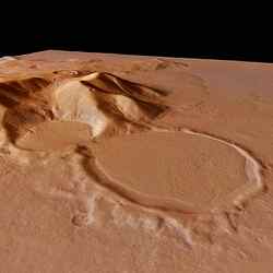
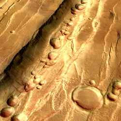
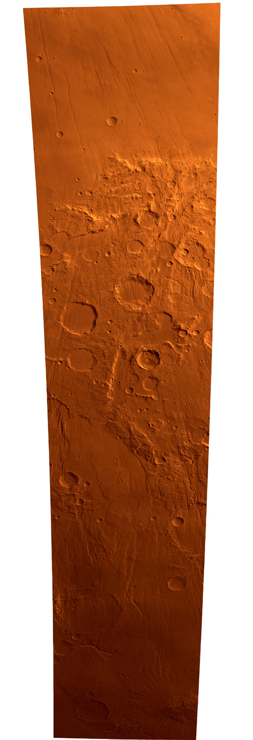
Perspective view of ‘hourglass’ shaped craters. Image credit: ESA Click to enlarge
The spectacular features visible today on the surface of the Red Planet indicate the past existence of Martian glaciers, but where did the ice come from?

An international team of scientists have produced sophisticated climate simulations suggesting that geologically recent glaciers at low latitudes (that is near the present-day equator) may have formed through atmospheric precipitation of water-ice particles.

Moreover, the results of the simulations show for the first time that the predicted locations for these glaciers match extensively with many of the glacier remnants observed today at these latitudes on Mars.

For several years, the presence, age and shape of these glacier remnants have raised numerous questions in the scientific community about their formation, and about the conditions on the planet when this happened.

To start narrowing down the rising number of hypotheses, a team led by Francois Forget, University of Paris 6 (France) and interdisciplinary scientist for ESA’s Mars Express mission, decided to ‘turn back the clock’ in their Martian global climate computer model, a tool usually applied to simulate the detail of present-day Mars meteorology.

As a starting point, Forget and colleagues had to make some assumptions – that the north polar cap was still the ice reservoir of the planet, and that the rotation axis was tilted by 45? with respect to the planet?s orbital plane.

“This makes the axis much more oblique than it is today (about 25?), but such an obliquity has probably been very common throughout Mars?s history. Actually, it last occurred only five and a half million years ago,” says Forget.

As expected with such a tilt, the greater solar illumination in the north polar summer increased the sublimation of the polar ice and led to a water cycle much more intense than today.

The simulations showed water ice being accumulated at a rate of 30 to 70 millimetres per year in a few localised areas on the flanks of the Elysium Mons, Olympus Mons and the three Tharsis Montes volcanoes.

After a few thousand years, the accumulated ice would form glaciers up to several hundreds of metres thick.

When the team compared the location and shape of the ‘simulated’ glaciers with the actual glacier-related deposits of Tharsis – one of the three main regions on the planet where signs of glaciers are seen – they found an excellent agreement.

In particular, the maximum deposition is predicted on the western flanks of the Arsia and Pavonis Montes of the Tharsis region, where the largest deposits in this area are actually observed.

In their simulations, the team could even ‘read’ why and how ice was accumulated on the flanks of these mountains in the Tharsis region millions of years ago.

Back then, constant year-long winds similar to monsoons on Earth would favour the upslope movement of water-rich air around Arsia and Pavonis Montes.

While being cooled down by tens of degrees, water would condense and form ice particles (larger than those we observe today in the Tharsis region’s clouds) that settled on the surface.

Other mountains like Olympus Mons show smaller-scale deposits because, according to the simulations, they were exposed to the monsoon-type strong winds and water-rich air only during the northern summer.

“The north polar cap may not have always been the only source of water during the planet’s high obliquity periods,” adds Forget.

“So we ran simulations assuming that ice was available in the south polar cap. We could still see ice accumulation in the Tharsis region, but this time also on the east of the Hellas Basin, a six-kilometre deep crater.”

This would explain the origins of another major area where ice-related landforms are observed today, the eastern Hellas Basin. indeed.

“The Hellas basin is in fact so deep as to induce the generation of a northward wind flow on its eastern side that would carry most of the water vapour sublimating from the south polar cap during summer. When the water-rich air meet colder air mass over eastern Hellas, water condense, precipitate, and form glaciers,” said Forget.

However, the team could not predict ice deposition in the Deuterolinus-Protonilus Mensae region, where glaciers could have been formed by other mechanisms. The scientists are considering several other hypotheses on the formation of recent glaciers.

For instance, observations of Olympus Mons by the High Resolution Stereo Camera on board Mars Express suggest that movement of water from the subsurface to the surface due to hydrothermal activity may have led to the development of glaciers on the cold surface.

Original Source: ESA Mars Express