
NASA’s next mission to the surface of the Red Planet is the Phoenix Mars Lander, due for launch in August 2007. This week, engineers at the Phoenix Science Operations Center at the University of Arizona began connecting science payload instruments to a mock lander to see how well the components work with each other. Phoenix will touch down onto the surface of Mars in 2008, and examine the soil for evidence of past water, and to see if the habitat has the potential to support life.
Continue reading “Phoenix Lander is Coming Together”
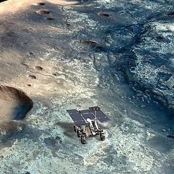
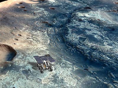
Mars Reconnaissance Orbiter Continues to Lower its Orbit
NASA’s newest visitor to the Red Planet, the Mars Reconnaissance Orbiter, is still in the process of shrinking its orbit, enroute to its final science orbit. When the spacecraft first arrived, its farthest point from the planet was 45,000 kilometers (28,000 miles). After 11 weeks of aerobraking operations, it’s reduced this distance to about 20,000 km (12,000 miles). Controllers estimate that the spacecraft will still need to sweep through Mars atmosphere 400 more times over the next 12 weeks to complete its orbital maneuvers. Its final mapping orbit will be approximately 255 to 320 km (160 to 200 mi) above the Martian surface.
Continue reading “Mars Reconnaissance Orbiter Continues to Lower its Orbit”
Ancient Martian Volcano Caldera
This image, taken by ESA’s Mars Express spacecraft, shows Apollinaris Patera, an ancient volcano caldera near Gusev Crater on Mars. The massive volcano measures 180 by 280 kilometres (112 by 174 miles) at its base and rises 5 km (3 miles) above the surrounding terrain. The bluish-tinted haze are thin clouds above the rim of the caldera.
Continue reading “Ancient Martian Volcano Caldera”
Aram Chaos on Mars
This false colour image, taken by ESA’s Mars Express spacecraft, shows the heavily eroded Aram Chaos region on Mars. The region is a 280-km (174-mile) wide circular structure located between two outflow channels. Scientists think that the eastern portion of the nearby Valles Marineris was responsible for torrents of ice and water that chopped up the landscape millions of years ago.
These images, taken by the High Resolution Stereo Camera (HRSC) on board ESA’s Mars Express spacecraft, show Aram Chaos, 280-km-wide circular structure characterized by chaotic terrain.
The HRSC obtained these images during orbit 945 with a ground resolution of approximately 14 metres per pixel. The images show the region of Aram Chaos, at approximately 2 North and 340 East.
Aram Chaos is a 280-km-wide almost-circular structure located between the outflow channel Ares Vallis and Aureum Chaos. It is one of many regions located east of Valles Marineris and characterized by chaotic terrain.
As the name ‘chaos’ suggests, this terrain comprises large-scale remnant massifs, large relief masses that have been moved and weathered as a block. These are heavily eroded and dominate the circular morphology, or structure, which may have formed during an impact. As seen in the colour image, these remnant massifs range from a few kilometres to approximately ten kilometres wide and have a relative elevation of roughly 1000 metres.
The western region of the colour image is characterized by brighter material, which seems to be layered and could be the result of sedimentary deposition. Distinct layering, causing a terrace-like appearance, is also visible east of this brighter material and in the relatively flat region located in the northwest of the colour image.
***image4:left***Some scientists believe that the numerous chaotic regions located in the eastern part of Valles Marineris were the source of water or ice thought to have created the valleys that extend into Chryse Planitia. These regions are particularly interesting because they may yield clues to the relationship between Valles Marineris, the chaotic terrain, the valleys and the Chryse basin.
The colour scenes have been derived from the three HRSC-colour channels and the nadir channel. The perspective view has been calculated from the digital terrain model derived from the stereo channels. The anaglyph image was calculated from the nadir and one stereo channel.
Original Source: ESA Mars Express
Lava Tubes on Pavonis Mons
Lava tubes down the side of Pavonis Mons. Image credit: ESA. Click to enlarge
This photograph shows one of Mars’ three great shield volcanos: Pavonis Mons. The image was taken by ESA’s Mars Express spacecraft, and shows a top view of the extinct volcano as it rises 12 km (7.5 miles) above the surrounding plains. Scientists believe the linear features are lava tubes that were created when the volcano was active. Similar to here on Earth, lava forms a crust on top while molten rock continues to flow under the surface. The longest tube extends over 59 km (37 miles).
This image, taken by the High Resolution Stereo Camera (HRSC) on board ESA’s Mars Express, shows Pavonis Mons, the central volcano of the three ‘shield’ volcanoes that comprise Tharsis Montes.
ESA’s Mars Express spacecraft obtained this image using the HRSC during orbit 902 with a ground resolution of approximately 14.3 metres per pixel. The image was acquired in the region of Pavonis Mons, at approximately 0.6° South and 246.4° East.
The context map is centred on Pavonis Mons, one of the three volcanoes called Tharsis Montes (the others being Arsia and Ascreus Montes, aligned with Pavonis in a line nearly 1500 km long).
Pavonis Mons, rising roughly 12 km above the surrounding plains, is the central volcano of the three ‘shield’ volcanoes that comprise Tharsis Montes. Gently sloping shield volcanoes are shaped like a flattened dome and are built almost exclusively of lava flows.
The dramatic features visible in the colour image are located on the south-west flank of Pavonis Mons. Researchers believe these are lava tubes, channels originally formed by hot, flowing lava that forms a crust as the surface cools. Lava continues to flow beneath this hardened surface, but when the lava production ends and the tunnels empty, the surface collapses, forming elongated depressions. Similar tubes are well known on Earth and the Moon.
The long, continuous lava tube in the northwest of the colour image extends over 59 km and ranges from approximately 1.9 km to less than 280 m wide.
Pit chains, strings of circular depressions thought to form as the result of collapse of the surface, are also visible within the colour image. In the northeast, there is a clear distinction between the brighter terrain at higher elevations and darker material located down slope. In the southwest, the lava tubes appear to be covered by subsequent lava flows.
By studying Martian volcanoes, scientists can obtain information regarding this intriguing planet. For example, the gradual flank slopes and the flattened, dome-like appearance of Pavonis Mons suggest that low-viscosity lava formed this volcano.
Original Source: ESA News Release
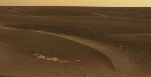
Exposed Bedrock on Mars
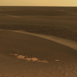
Cobbles appearing on trough floors between wind-blown ripples. Image credit: NASA/JPL. Click to enlarge
NASA’s Opportunity rover captured this photograph of the surface of Mars during its trek from Erebus Crater to Victoria Crater. The image shows exposed bedrock between large windblown sand ripples. Opportunity took the photo on April 27, 2006 during its 802nd Martian day of exploration.
As NASA’s Mars Exploration Rover Opportunity continues to traverse from “Erebus Crater” toward “Victoria Crater,” the rover navigates along exposures of bedrock between large, wind-blown ripples. Along the way, scientists have been studying fields of cobbles that sometimes appear on trough floors between ripples. They have also been studying the banding patterns seen in large ripples.
This view, obtained by Opportunity’s panoramic camera on the rover’s 802nd Martian day (sol) of exploration (April 27, 2006), is a mosaic spanning about 30 degrees. It shows a field of cobbles nestled among wind-driven ripples that are about 20 centimeters (8 inches) high.
The origin of cobble fields like this one is unknown. The cobbles may be a lag of coarser material left behind from one or more soil deposits whose finer particles have blown away. The cobbles may be eroded fragments of meteoritic material, secondary ejecta of Mars rock thrown here from craters elsewhere on the surface, weathering remnants of locally-derived bedrock, or a mixture of these. Scientists will use the panoramic camera’s multiple filters to study the rock types, variability and origins of the cobbles. This is an approximately true-color rendering that combines separate images taken through the panoramic camera’s 753-nanometer, 535-nanometer and 432-nanometer filters.
Original Source: NASA News Release
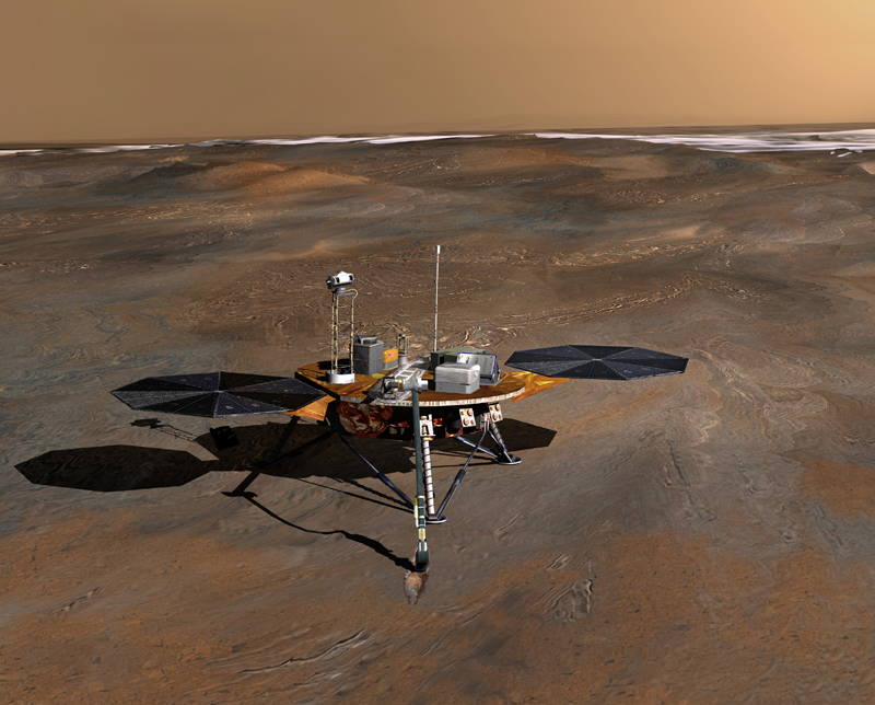
Pheonix Mars Lander is Coming Together
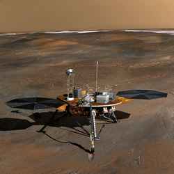
Artist’s concept of Phoenix spacecraft. Image credit: NASA. Click to enlarge
NASA’s next mission to the Red Planet, the Phoenix Mars Lander, is coming together in preparation for its August 2007 launch. Engineers are now incorporating many of its subsystems, including the flight computer, power systems and science instruments. If all goes well, the spacecraft will land near Mars’ north polar ice cap, and analyze samples that it scoops up from the icy soil.
NASA’s Phoenix Mars Lander, the next mission to the surface of Mars, is beginning a new phase in preparation for a launch in August 2007.
As part of this “assembly, test and launch operations” phase, Phoenix team members are beginning to add complex subsystems such as the flight computer, power systems and science instruments to the main structure of the spacecraft. The work combines efforts of Lockheed Martin Space Systems, Denver; the University of Arizona, Tucson; and NASA’s Jet Propulsion Laboratory, Pasadena, Calif.
“All the subsystems and instruments from a wide range of suppliers are tested separately, but now we are beginning the vital stage of assembling them together and testing how they will function with each other,” said JPL’s Barry Goldstein, project manager for Phoenix.
Phoenix will land near the red planet’s north polar ice cap to analyze scooped-up samples of icy soil.
“We know there is plenty of water frozen into the surface layer of Mars at high latitudes. We’ve designed Phoenix to tell us more about this region as a possible habitat for life,” said the University of Arizona’s Peter Smith, principal investigator for the mission.
Phoenix is the first mission of NASA’s Mars Scout Program of competitively proposed, relatively low-cost missions to Mars. The program is currently soliciting proposals for a 2011 Scout mission.
The Phoenix proposal, selected in 2003, saves expense by using a lander structure, subsystem components and protective aeroshell originally built for a 2001 lander mission that was canceled while in development. The budget for the Phoenix mission, including launch, is $386 million.
The spacecraft will land using descent thrusters just prior to touchdown, rather than airbags like those used by the current Mars Exploration Rovers. As Phoenix parachutes through Mars’ lower atmosphere in May 2008, a descent camera will take images for providing geological context about the landing site.
The robotic arm being built for Phoenix will be about 2 meters (7 feet) long, jointed at the elbow and wrist, and equipped with a camera and scoop. It will dig as deep as about 50 centimeters (20 inches) and deliver samples to instruments on the spacecraft deck that will analyze physical and chemical properties of the ices and other materials. A stereo color camera will examine the landing site’s terrain and provide positioning information for the arm. The Canadian Space Agency is providing a suite of weather instruments for Phoenix.
“The propulsion system and the wiring harness have been added to the vehicle,” said Ed Sedivy, Phoenix program manager for Lockheed Martin. “We will be loading flight software onto the flight computer in the next few days. The flight software is much more mature than typical for a planetary program at this stage. As soon as the flight computer is mated up, we can apply external power to the vehicle.”
Navigation components, such as star trackers, and communication subsystems will become part of the spacecraft in coming weeks, followed by science instruments in the summer.
Phoenix will be shipped to NASA’s Kennedy Space Center, Florida, in May 2007, for final preparations leading up to launch. Before that, testing in Colorado will subject the spacecraft to expected operational environments. This includes thermal and vacuum tests simulating the 10-month trip to Mars and conditions on Mars’ surface. Meanwhile, the mission is preparing a test facility in Tucson for practicing and testing procedures for operating the spacecraft on Mars.
JPL, a division of the California Institute of Technology, Pasadena, manages Phoenix for NASA’s Science Mission Directorate.
For information about NASA and agency programs on the Web, visit http://www.nasa.gov . For information about the Phoenix Mission to Mars on the Web, visit http://phoenix.lpl.arizona.edu.
Original Source: NASA News Release
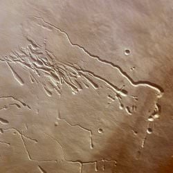
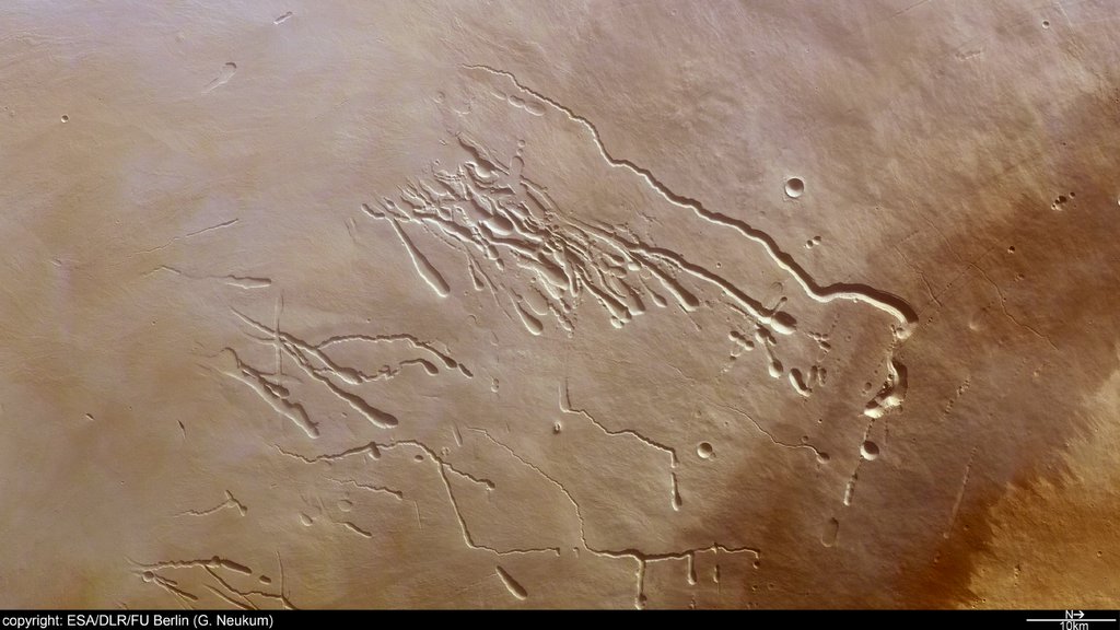
Nanedi Valles on Mars
This image, taken by ESA’s Mars Express spacecraft, shows the Nanedi Valles region of Mars. These steep sided channels range in width from a few hundred meters to more than 5km (3 miles) across, and look like they were formed by quickly flowing water. But their origin is debated by researchers. Some think that liquid flowed under the surface and the ground collapsed above it, while others think that water did once flow on the surface.
These images, taken by the High Resolution Stereo Camera (HRSC) on board ESA’s Mars Express spacecraft, show the Nanedi Valles valley system, a steep-sided feature that may have been formed in part by free-flowing water.
The HRSC obtained these images on 3 October 2004 during orbit 905 at a ground resolution of approximately 18 metres per pixel. The images have been rotated 90 degrees clockwise, so that north is to the right.
They show the region of Nanedi Valles, a roughly 800-kilometre valley extending southwest-northeast and lying at approximately 6.0 degrees North and 312 degrees East in the region of Xanthe Terra, southwest of Chryse Planitia.
In the colour image, Nanedi Valles ranges from approximately 0.8- to 5.0-kilometre wide and extends to a maximum of about 500 metres below the surrounding plains. This valley is relatively flat-floored and steep-sloped, and exhibits meanders and a merging of two branches in the north.
The origin of these striking features remains heavily debated.
***image4:left***Some researchers point to sapping (erosion caused by ground-water outflow), while others suggest that flow of liquid beneath an ice cover or collapse of the surface in association with liquid flow is responsible for the valley’s formation.
While the debate continues, it seems likely that some sort of continuous flow rather than a single flooding event created these features.
By studying Nanedi Valles, scientists hope to better understand the climatic evolution of the Red Planet. The stereo and colour capabilities of the HRSC camera enable scientists to study the planet’s morphology, while researchers can analyse reflected light at different wavelengths to better recognise the various geologic units within a scene.
The colour images have been derived from the three HRSC colour channels and the nadir channel. The anaglyph image was calculated from the nadir and one stereo channel.
Original Source: ESA Mars Express
Sites to Look for Life on Mars
OMEGA instrument has identified clay beds which supported life in the past. Image credit: ESA/OMEGA. Click to enlarge
ESA’s Mars Express spacecraft has completed an extensive map of minerals across the surface of Mars, pointing at the places future rovers might want to search for life. This new analysis shows that lakes and oceans might have been present on Mars, but they disappeared more than 4 billion years ago. That wouldn’t have given life much time to get a serious foothold before the whole planet became a desert. So these pockets of hydrated minerals would be the best places to try and find evidence of past life.
By mapping minerals on the surface of Mars using the European Space Agency’s Mars Express spacecraft, scientists have discovered the three ages of Martian geological history – as reported in today’s issue of Science – and found valuable clues as to where life might have developed.
The new work shows that large bodies of standing water might only have been present on Mars in the remote past, before four thousand million years ago, if they were present at all. Within half a billion years, these conditions had faded away.
The results come from the Observatoire pour la Mineralogie, l’Eau, les Glaces et l’Activite (OMEGA) instrument on board Mars Express. In one Martian year (687 Earth days) of operation, OMEGA mapped 90 percent of the surface, allowing the identification of a variety of minerals and the processes by which they have been altered during the course of Martian history. The maps have allowed a team of scientists, led by Professor Jean-Pierre Bibring, Institut d’Astrophysique Spatiale (IAS), Orsay (France), to identify three geological eras for Mars.
The earliest, named by the authors as the ‘phyllosian’ era, occurred between 4.5-4.2 thousand million years ago, soon after the planet formed. The environment was possibly warm and moist at this time, allowing the formation of large-scale clay beds, many of which survive today.
The second era, the ‘theiikian’, took place between 4.2 and 3.8 billion years ago. It was prompted by planet-wide volcanic eruptions that drove global climate change. In particular, the sulphur these eruptions belched into the atmosphere reacted with the water to produce acid rain, which altered the composition of the surface rocks where it fell.
Finally, there was the ‘siderikian’, the longest lasting of the Martian eras. It began sometime around 3.8-3.5 billion years ago and continues today. There is little water involved in this era; instead, the rocks appear to have been altered during slow weathering by the tenuous Martian atmosphere. This process gave Mars its red colour.
The eras are named after the Greek words for the predominant minerals formed within them. The one most likely to have supported life was the phyllosian, when clay beds could have formed at the bottom of lakes and seas, providing the damp conditions in which the processes of life could begin.
However, there are still question marks. The team points out that the clay beds might have been formed underground, rather than in lakebeds.
“Hydrothermal activity below the surface, the impact of water-bearing asteroids, even the natural cooling of the planet could all have promoted the formation of clay below Mars’s surface. If so, the surface conditions may always have been cold and dry,” said Bibring.
After this initial period, water largely disappeared from the planet’s surface either by seeping underground or being lost into space. Except for a few localised transient water events, Mars became the dry, cold desert seen by spacecraft today. This new identification of clay beds on Mars provides high-priority targets for future Mars landers that seek to investigate whether Mars once harboured life.
“If living organisms formed, the clay material would be where this biochemical development took place, offering exciting places for future exploration because the cold Martian conditions could have preserved most of the record of biological molecules up to the present day,” concluded Bibring.
Original Source: ESA Portal
Building an Antimatter Spaceship

If you’re looking to build a powerful spaceship, nothing’s better than antimatter. It’s lightweight, extremely powerful and could generate tremendous velocity. However, it’s enormously expensive to create, volatile, and releases torrents of destructive gamma rays. NASA’s Institute for Advanced Concepts is funding a team of researchers to try and design an antimatter-powered spacecraft that could avoid some of those problems.
Most self-respecting starships in science fiction stories use anti matter as fuel for a good reason – it’s the most potent fuel known. While tons of chemical fuel are needed to propel a human mission to Mars, just tens of milligrams of antimatter will do (a milligram is about one-thousandth the weight of a piece of the original M&M candy).
However, in reality this power comes with a price. Some antimatter reactions produce blasts of high energy gamma rays. Gamma rays are like X-rays on steroids. They penetrate matter and break apart molecules in cells, so they are not healthy to be around. High-energy gamma rays can also make the engines radioactive by fragmenting atoms of the engine material.
The NASA Institute for Advanced Concepts (NIAC) is funding a team of researchers working on a new design for an antimatter-powered spaceship that avoids this nasty side effect by producing gamma rays with much lower energy.
Antimatter is sometimes called the mirror image of normal matter because while it looks just like ordinary matter, some properties are reversed. For example, normal electrons, the familiar particles that carry electric current in everything from cell phones to plasma TVs, have a negative electric charge. Anti-electrons have a positive charge, so scientists dubbed them “positrons”.
When antimatter meets matter, both annihilate in a flash of energy. This complete conversion to energy is what makes antimatter so powerful. Even the nuclear reactions that power atomic bombs come in a distant second, with only about three percent of their mass converted to energy.
Previous antimatter-powered spaceship designs employed antiprotons, which produce high-energy gamma rays when they annihilate. The new design will use positrons, which make gamma rays with about 400 times less energy.
The NIAC research is a preliminary study to see if the idea is feasible. If it looks promising, and funds are available to successfully develop the technology, a positron-powered spaceship would have a couple advantages over the existing plans for a human mission to Mars, called the Mars Reference Mission.
“The most significant advantage is more safety,” said Dr. Gerald Smith of Positronics Research, LLC, in Santa Fe, New Mexico. The current Reference Mission calls for a nuclear reactor to propel the spaceship to Mars. This is desirable because nuclear propulsion reduces travel time to Mars, increasing safety for the crew by reducing their exposure to cosmic rays. Also, a chemically-powered spacecraft weighs much more and costs a lot more to launch. The reactor also provides ample power for the three-year mission. But nuclear reactors are complex, so more things could potentially go wrong during the mission. “However, the positron reactor offers the same advantages but is relatively simple,” said Smith, lead researcher for the NIAC study.
Also, nuclear reactors are radioactive even after their fuel is used up. After the ship arrives at Mars, Reference Mission plans are to direct the reactor into an orbit that will not encounter Earth for at least a million years, when the residual radiation will be reduced to safe levels. However, there is no leftover radiation in a positron reactor after the fuel is used up, so there is no safety concern if the spent positron reactor should accidentally re-enter Earth’s atmosphere, according to the team.
It will be safer to launch as well. If a rocket carrying a nuclear reactor explodes, it could release radioactive particles into the atmosphere. “Our positron spacecraft would release a flash of gamma-rays if it exploded, but the gamma rays would be gone in an instant. There would be no radioactive particles to drift on the wind. The flash would also be confined to a relatively small area. The danger zone would be about a kilometer (about a half-mile) around the spacecraft. An ordinary large chemically-powered rocket has a danger zone of about the same size, due to the big fireball that would result from its explosion,” said Smith.
Another significant advantage is speed. The Reference Mission spacecraft would take astronauts to Mars in about 180 days. “Our advanced designs, like the gas core and the ablative engine concepts, could take astronauts to Mars in half that time, and perhaps even in as little as 45 days,” said Kirby Meyer, an engineer with Positronics Research on the study.
Advanced engines do this by running hot, which increases their efficiency or “specific impulse” (Isp). Isp is the “miles per gallon” of rocketry: the higher the Isp, the faster you can go before you use up your fuel supply. The best chemical rockets, like NASA’s Space Shuttle main engine, max out at around 450 seconds, which means a pound of fuel will produce a pound of thrust for 450 seconds. A nuclear or positron reactor can make over 900 seconds. The ablative engine, which slowly vaporizes itself to produce thrust, could go as high as 5,000 seconds.
One technical challenge to making a positron spacecraft a reality is the cost to produce the positrons. Because of its spectacular effect on normal matter, there is not a lot of antimatter sitting around. In space, it is created in collisions of high-speed particles called cosmic rays. On Earth, it has to be created in particle accelerators, immense machines that smash atoms together. The machines are normally used to discover how the universe works on a deep, fundamental level, but they can be harnessed as antimatter factories.
“A rough estimate to produce the 10 milligrams of positrons needed for a human Mars mission is about 250 million dollars using technology that is currently under development,” said Smith. This cost might seem high, but it has to be considered against the extra cost to launch a heavier chemical rocket (current launch costs are about $10,000 per pound) or the cost to fuel and make safe a nuclear reactor. “Based on the experience with nuclear technology, it seems reasonable to expect positron production cost to go down with more research,” added Smith.
Another challenge is storing enough positrons in a small space. Because they annihilate normal matter, you can’t just stuff them in a bottle. Instead, they have to be contained with electric and magnetic fields. “We feel confident that with a dedicated research and development program, these challenges can be overcome,” said Smith.
If this is so, perhaps the first humans to reach Mars will arrive in spaceships powered by the same source that fired starships across the universes of our science fiction dreams.
Original Source: NASA News Release