Ancient Groundwater Flows Revealed on Mars

Deformation bands on Mars. credit: NASA/JPL-Caltech/Univ. of Arizona

[/caption]
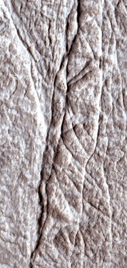
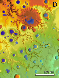
NASA’s Mars Reconnaissance Orbiter has revealed hundreds of small fractures exposed on the Martian surface that billions of years ago directed flows of water through underground Martian sandstone. Researchers used images from the spacecraft’s HiRISE (High Resolution Imaging Science Experiment) camera. Images of layered rock deposits at equatorial Martian sites show the clusters of fractures to be a type called deformation bands, caused by stresses below the surface in granular or porous bedrock. “Groundwater often flows along fractures such as these, and knowing that these are deformation bands helps us understand how the underground plumbing may have worked within these layered deposits,” said Chris Okubo of the U.S. Geological Survey in Flagstaff, Ariz.

Visible effects of water on the color and texture of rock along the fractures provide evidence that groundwater flowed extensively along the fractures. “These structures are important sites for future exploration and investigations into the geological history of water and water-related processes on Mars,” Okubo and co-authors state in a report published online this month in the Geological Society of America Bulletin.

Deformation bands in the Four Corners region of the US.  Credit:  Jon E. Olson
Deformation bands in the Four Corners region of the US. Credit: Jon E. Olson

Deformation band clusters in Utah sandstones, as on Mars, are a few meters or yards wide and up to a few kilometers or miles long. They form from either compression or stretching of underground layers, and can be precursors to faults. The ones visible at the surface have become exposed as overlying layers erode away. Deformation bands and faults can strongly influence the movement of groundwater on Earth and appear to have been similarly important on Mars, according to this study.

“This study provides a picture of not just surface water erosion, but true groundwater effects widely distributed over the planet,” said Suzanne Smrekar, deputy project scientist for the Mars Reconnaissance Orbiter at NASA’s Jet Propulsion Laboratory in Pasadena, Calif. “Groundwater movement has important implications for how the temperature and chemistry of the crust have changed over time, which in turn affects the potential for habitats for past life.”
Deformation bands form when sections of rock slide past each other and are similar to faults, such as the much larger San Andreas Fault in southern California. The discovery of deformation bands in HiRISE images advances understanding of how underground fractures would have affected the distribution and availability of ancient groundwater on Mars.

The HiRISE camera took the top image of layered rocks inside a crater in the Arabia Terra region of Mars on Feb. 13, 2007. The site is at 6.6 degrees north latitude, 14.1 degrees east longitude. Illumination is from the left. North is toward the top. The ground covered in this image spans about 150 meters (about 500 feet) east to west.

Source: NASA

Phoenix Lander Successful in Moving “Headless” Rock

"Headless" after being moved. Credit: NASA/JPL/Caltech/U of AZ

[/caption]

The robotic arm on NASA’s Phoenix Mars Lander slid a rock out of the way during the mission’s 117th Martian day (Sept. 22, 2008) in order to take a look at the soil underneath the rock, and to see at what depth the subsurface ice was under the rock. The lander’s Surface Stereo Imager took this image later the same day, showing the rock, called “Headless,” after the arm pushed it about 40 centimeters (16 inches) from its previous location. “The rock ended up exactly where we intended it to,” said Matt Robinson of NASA’s Jet Propulsion Laboratory, robotic arm flight software lead for the Phoenix team. And what was underneath the rock? Take a look:

Post flip.  Credit:  NASA/JPL/Caltech/Uof AZ
It’s hard to tell, exactly since the ground was disturbed from the moving. Some white material appears to be where the rock used to sit, but the Phoenix science team will have to study the area more closely. Look for official word from the team soon. It looks from this second image as though the thermal and conductivity probe was stuck in the ground a few times around the rock, searching for clues of any water molecules in the soil (look for the two separate marks left by the probe just to the right of the trench.)
Phoenix sol 118.  Credit:  NASA/JPL/Caltech/U of AZ

RAC (via the SSI).  Credit: NASA/JPL/Caltech/U of AZ
RAC (via the SSI). Credit: NASA/JPL/Caltech/U of AZ

Also in recent days, the two Phoenix cameras took portraits of each other. Above is the Robotic Arm Camera (RAC) and below is the the Surface Stereo Imager:

Phoenix Surface Stereo Image-twitterpic.  Credit:  Twitter
Phoenix Surface Stereo Image-twitterpic. Credit: Twitter

Source: Phoenix Gallery

Opportunity’s Next Adventure: The Big Drive

The Big Drive to Endeavour-crater. Credit: NASA/JPL

[/caption]

Opportunity, the intrepid Mars Exploration Rover, is going to put the pedal to the metal and head out for a crater nearly 12 kilometers (7 miles) away. That would match the distance the rover has traveled since landing in 2004. But the call of the unknown is compelling the rover science team to make the attempt. “We may not get there, but it is scientifically the right direction to go anyway,” said Steve Squyres, principal investigator for the science instruments on Opportunity and its twin rover, Spirit. For an “aging” rover (what age is 4 in rover years?), this might be setting the bar pretty high. But maybe it’s the journey and not the destination.

“This is a bolder, more aggressive objective than we have had before,” said John Callas, the project manager the rovers. “It’s tremendously exciting. It’s new science. It’s the next great challenge for these robotic explorers.”

“This crater is staggeringly large compared to anything we’ve seen before.” The crater, named Endeavour, is 22 kilometers (13.7 miles) across. “I would love to see that view from the rim,” Squyres said. “But even if we never get there, as we move southward we expect to be getting to younger and younger layers of rock on the surface. Also, there are large craters to the south that we think are sources of cobbles that we want to examine out on the plain. Some of the cobbles are samples of layers deeper than Opportunity will ever see, and we expect to find more cobbles as we head toward the south.”

The rover team estimates Opportunity may be able to travel about 110 yards each day it is driven toward the Endeavour crater. Even at that pace, the journey could take two years. But why not go for it, and see how long the rovers can last?

Opportunity's shadow with Victoria Crater in the background.  Credit:  NASA/JPL/ASU
Opportunity's shadow with Victoria Crater in the background. Credit: NASA/JPL/ASU

Opportunity, like Spirit, is well past its expected lifetime on Mars, and might not keep working long enough to reach the crater. However, two new resources not available during the 4-mile drive toward Victoria Crater in 2005 and 2006 are expected to aid in this new trek.

One is imaging from orbit of details smaller than the rover itself, using the High Resolution Imaging Science Experiment (HiRISE) camera on NASA’s Mars Reconnaissance Orbiter, which arrived at the Red Planet in 2006.

“HiRISE allows us to identify drive paths and potential hazards on the scale of the rover along the route,” Callas said. “This is a great example of how different parts of NASA’s Mars Exploration Program reinforce each other.”

Also, Opportunity now has a better “brain” for driving across the the plains of Mars. A new version of flight software uplinked to Opportunity and Spirit in 2006, boosts their ability to autonomously choose routes and avoid hazards such as sand dunes.

During its first year on Mars, Opportunity found geological evidence that the area where it landed had surface and underground water in the distant past. The rover’s explorations since have added information about how that environment changed over time. Finding rock layers above or below the layers already examined adds windows into later or earlier periods of time.

Source: JPL

Anything Under That Rock on Mars? Phoenix to Take a Peek

The rock "Headless." NASA/JPL-Caltech/University of Arizona/ Texas A&M University

[/caption]
Ever wondered what might crawl out from under a rock on Mars? The Phoenix lander is going to attempt to find out today by trying to nudge a rock aside today with its robotic arm to see what might be underneath. Engineers have developed a plan to try moving a rock on the north side of the lander. This rock, roughly the size and shape of a VHS videotape, is called “Headless.” Even though the Phoenix mission has been extended for a second time – the mission is now on through December, the team feels like it’s time to pull out all the stops and do as much work as possible. “We’re getting towards fall in the northern plains of Mars and our sun is dropping lower day by day,” said mission principal investigator Peter Smith on NPR’s Science Friday. “Our days are getting precious.” So, even though Phoenix’s robotic arm was not designed to move rocks, the team wants to give it a shot. “The appeal of studying what’s underneath is so strong we have to give this a try,” said Michael Mellon, a Phoenix science team member at the University of Colorado, Boulder.

“We don’t know whether we can do this until we try,” said Ashitey Trebi Ollennu, a robotics engineer at NASA’s Jet Propulsion Laboratory, Pasadena, Calif. “The idea is to move the rock with minimum disturbance to the surface beneath it. You have to get under it enough to lift it as you push it and it doesn’t just slip off the scoop.”

The lander receives commands for the whole day in the morning, so there’s no way to adjust in mid-move if the rock starts slipping. Phoenix took stereo-pair images of Headless to provide a detailed three-dimensional map of it for planning the arm’s motions. On Saturday, Sept. 20, the arm enlarged a trench close to Headless. Commands sent to Phoenix Sunday evening, Sept. 21, included a sequence of arm motions for today, intended to slide the rock into the trench.

If the technique works, the move would expose enough area for digging into the soil that had been beneath Headless.

Morning frost on Mars.  NASA/JPL-Caltech/University of Arizona/ Texas A&M University
Morning frost on Mars. NASA/JPL-Caltech/University of Arizona/ Texas A&M University

The scientific motive is related to a hard, icy layer found beneath the surface in trenches that the robotic arm has dug near the lander. Excavating down to that hard layer underneath a rock might provide clues about processes affecting the ice.

“The rocks are darker than the material around them, and they hold heat,” Mellon said. “In theory, the ice table should deflect downward under each rock. If we checked and saw this deflection, that would be evidence the ice is probably in equilibrium with the water vapor in the atmosphere.”

An alternative possibility, if the icy layer were found closer to the surface under a rock, could by the rock collecting moisture from the atmosphere, with the moisture becoming part of the icy layer.

Source: JPL

Why is Mars’ Southern Polar Cap Crooked?

Mars Express Data from Mars South Pole. Credits: ESA/ Image Courtesy of F. Altieri (IFSI-INAF) and the OMEGA team

[/caption]
Like Earth, Mars has frozen polar caps, but unlike Earth, these caps are made of carbon dioxide ice as well as water ice. During the southern hemisphere’s summer, much of the ice cap sublimates, or evaporates directly to a gas, but leaves behind what is known as the residual polar cap. The problem is that while the winter cap is symmetrical about the south pole, the residual cap is offset by some three to four degrees. Using data from ESA’s Mars Express spacecraft, scientists say two things are to blame: the Martian weather system, and interestingly, so is the largest impact crater on Mars – even though it is nowhere near the south pole.

Using the Planetary Fourier Spectrometer (PFS) onboard Mars Express, Marco Giuranna of the Istituto di Fisica dello Spazio Interplanetario CNR (IFSI), Rome, Italy, and colleagues have measured the temperature of Mars’ atmosphere from the ground up to an altitude of 50 km above the south polar region.

They charted the way the atmosphere changes in temperature and other characteristics over more than half a Martian year, and monitored the way carbon dioxide builds into the southern ice cap as the autumn turns into winter on Mars. “It is not a straightforward process. We found that two regional weather systems developed from mid-fall through the winter,” says Giuranna.

These weather systems are derived from strong eastward winds that blow straight into the Hellas Basin, the largest impact structure on Mars with a diameter of 2300 km and a depth of 7 km. The crater’s depth and the steep rise of the walls deflect the winds and create what are called Rossby waves on Earth. This creates a low pressure system near the south pole in the western hemisphere and a high-pressure system in the eastern hemisphere, again near the south pole.

Giuranna found that the temperature of the low-pressure system is often below the condensation point for carbon dioxide, so the gas condenses and falls from the sky as snow and builds up on the ground as frost. In the high-pressure system, the conditions are never appropriate for snow, so only ground frost occurs. Thus, the south polar cap is built by two different mechanisms.

The areas that have extensive snow cover do not sublimate in the summer because they reflect more sunlight back into space than the surface frost. Frost grains tend to be larger than snow grains and have rougher surfaces. The ragged texture traps more sunlight, driving the sublimation.

So the western area of the southern polar cap, built of snow and frost, not only has a larger amount of carbon dioxide ice deposited but also sublimates more slowly during the summer, while the western area built of frost disappears completely. This explains why the residual cap is not symmetrically placed around the south pole.

“This has been a martian curiosity for many years,” says Giuranna. Thanks to Mars Express, planetary scientists now understand a new facet of this amazing, alien world.

Source: ESA

Phoenix Lander Working Hard Before Summer’s End on Mars

The Phoenix Mars Lander is working as fast as it can to dig and deliver as many samples as possible before the power produced by Phoenix’s solar panels declines due to the end of the Martian summer. This image, from Sol 107 (Sept. 12 here on Earth), shows the lander has delivered a sample of soil from the “Snow White” trench to the Wet Chemistry Laboratory. A small pile of soil is visible on the lower edge of the second cell from the top. This deck-mounted lab is part of Phoenix’s Microscopy, Electrochemistry and Conductivity Analyzer (MECA).

The Wet Chemistry Laboratory mixes Martian soil with an water-based solution from Earth as part of a process to identify soluble nutrients and other chemicals in the soil. Preliminary analysis of this soil confirms that it is alkaline, and composed of salts and other chemicals such as perchlorate, sodium, magnesium, chloride and potassium. This data validates prior results from that same location, said Michael Hecht of NASA’s Jet Propulsion Laboratory, Pasadena, Calif., the lead scientist for MECA.

In the coming days, the Phoenix team will also fill the final four of eight single-use ovens on another soil-analysis instrument, the Thermal and Evolved Gas Analyzer, or TEGA.

Source: Phoenix news site

Newest Mission to Mars: MAVEN

Why do planets like Mars have a different atmosphere than Earth? Credit: NASA

[/caption]

Did Mars once have a thick atmosphere? Could the climate on the Red Planet have supported water and possibly life in the past? These are the questions NASA hopes to answer in great detail with the newest orbiter mission to Mars. Called the Mars Atmosphere and Volatile EvolutioN (MAVEN) spacecraft, the $485 million mission is scheduled for launch in late 2013. MAVEN is part of the Mars Scout Program, which is designed to send a series of small, low-cost, principal investigator-led missions to the Red Planet. The Phoenix Mars Lander was the first spacecraft selected in this program. “This mission will provide the first direct measurements ever taken to address key scientific questions about Mars’ evolution,” said Doug McCuistion, director of the Mars Exploration Program at NASA Headquarters in Washington.

Evidence from orbit and the planet’s surface points to a once denser atmosphere on Mars that supported the presence of liquid water on the surface. As part of a dramatic climate change, most of the Martian atmosphere was lost. MAVEN will make definitive scientific measurements of present-day atmospheric loss that will offer clues about the planet’s history.

“The loss of Mars’ atmosphere has been an ongoing mystery,” McCuistion said. “MAVEN will help us solve it.”

The science team will be led from the University of Colorado at Boulder, and its Laboratory for Atmospheric and Space Physics. The principal investigator for the mission is Bruce Jakosky from UC Boulder. “We are absolutely thrilled about this announcement,” said Jakosky. “We have an outstanding mission that will obtain fundamental science results for Mars. We have a great team and we are ready to go.”

Artist depiction of the MAVEN spacecraft.  Credit:  NASA
Artist depiction of the MAVEN spacecraft. Credit: NASA

Lockheed Martin of Littleton, Colo., will build the spacecraft based on designs from NASA’s Mars Reconnaissance Orbiter and 2001 Mars Odyssey missions.
MAVEN was evaluated to have the best science value and lowest implementation risk from 20 mission investigation proposals submitted in response to a NASA Announcement of Opportunity in August 2006.

After arriving at Mars in the fall of 2014, MAVEN will use its propulsion system to enter an elliptical orbit ranging 90 to 3,870 miles above the planet. The spacecraft’s eight science instruments will take measurements during a full Earth year, which is roughly equivalent to half of a Martian year.
MAVEN’s instrument suites include a remote sensing package that will determine global characteristics of the upper atmosphere, and the spacecraft will dip to an altitude of 80 miles above the planet. A particles and fields payload contains six instruments that will characterize the solar wind, upper atmosphere and the ionosphere – a layer of charged particles very high in the Martian atmosphere.

The third instrument suite, a Neutral Gas and Ion Mass Spectrometer will measure the composition and isotopes of neutral and charged forms of gases in the Martian atmosphere

During and after its primary science mission, the spacecraft may be used to provide communications relay support for robotic missions on the Martian surface.

More information on MAVEN.

Sources: NASA, UC Boulder

Phoenix Spies – and Feels – Dust Devils

A dust devil dances in the distance from the Phoenix lander. Credit: NASA/JPL/Caltech/U of AZ

[/caption]

Not only has the Phoenix Mars Lander photographed several dust devils dancing across the arctic plain this week, but sensors that monitor various atmospheric conditions around the lander detected a dip in air pressure as one of the whirlwinds passed nearby. This is the first time dust devils have been detected in Phoenix images. Scientists believe the increasing difference between daytime high temperatures (about -30C) and night lows (around -90C) is the key to the formation of the dust devils. Click here to download a dust devil movie created from the images.

The Surface Stereo Imager camera on Phoenix took 29 images of the western and southwestern horizon on Sept. 8, during mid-day hours of the lander’s 104th Martian day. The next day, after the images had been transmitted to Earth, the Phoenix science team noticed a dust devil right away.

“It was a surprise to have a dust devil so visible that it stood with just the normal processing we do,” said Mark Lemmon of Texas A&M University, College Station, lead scientist for the stereo camera. “Once we saw a couple that way, we did some additional processing and found there are dust devils in 12 of the images.”

Another image of a dust devil from Phoenix.  Credit:  NASA/JPL/Caltech/U of AZ
Another image of a dust devil from Phoenix. Credit: NASA/JPL/Caltech/U of AZ

At least six different dust devils appear in the images, some of them in more than one image. They range in diameter from about 2 meters (7 feet) to about 5 meters (16 feet).

The Phoenix team is not worried about any damage to the spacecraft from these swirling winds. “With the thin atmosphere on Mars, the wind loads we might experience from dust devil winds are well within the design of the vehicle,” said Ed Sedivy, Phoenix program manager at Lockheed Martin Space Systems Company, Denver, which made the spacecraft. “The lander is very rigid with the exception of the solar arrays, which once deployed, latched into position and became a tension structure.”

Phoenix monitors air pressure every day, and on the same day the camera saw dust devils, the pressure meter recorded a sharper dip than ever before. The change was still less than the daily change in air pressure from daytime to nighttime, but over a much shorter time.

“Throughout the mission, we have been detecting vortex structures that lower the pressure for 20 to 30 seconds during the middle part of the day,” said Peter Taylor of York University, Toronto, Canada, a member of the Phoenix science team. “In the last few weeks, we’ve seen the intensity increasing, and now these vortices appear to have become strong enough to pick up dust.”

The same day as the dust devils were seen, the photographed swinging of Phoenix’s telltale wind gauge indicated wind speeds exceeding 5 meters per second (11 miles per hour). Download a movie of the telltail wind gauge.

Images from spacecraft orbiting Mars had previously indicated that dust devils exist in the region where Phoenix landed.

“We expected dust devils, but we are not sure how frequently,” said Phoenix Project Scientist Leslie Tamppari of NASA’s Jet Propulsion Laboratory, Pasadena, Calif. “It could be they are rare and Phoenix got lucky. We’ll keep looking for dust devils at the Phoenix site to see if they are common or not.”

The dust devils that Phoenix has observed so far are much smaller than dust devils that NASA’s Mars Exploration Rover Spirit has photographed much closer to the equator.

Source: Phoenix news site.

Clumps Growing on Phoenix Lander Legs

Clumps of material have adhered to the legs of the Phoenix Mars Lander, and the clumps continue to change and grow. The science team has discussed various possible explanations for these clumps. One suggestion is that they may have started from a splash of mud if Phoenix’s descent engines melted icy soil during the landing. Another is that specks of salt may have landed on the strut and began attracting atmospheric moisture that freezes and accumulates. The clumps are concentrated on the north side of the strut, usually in the shade, so their accumulation could be a consequence of the fact that condensation favors colder surfaces. Below, compare images taken on September 1, 2008, or the 97th Martian Day or sol, since landing with another image taken about three months earlier, on Sol 8.

Sol 97 image under the lander.  Credit:  NASA/JPL/Caltech/U of AZ

Sol 8 image from under the lander.  Credit:  NASA/JPL/Caltech/U of AZ

Phoenix’s Robotic Arm Camera took both images. The top image from Sol 97 was taken at about 4 a.m. local solar time. The view in this Sol 97 image is southward. Illumination is from the early morning sun above the northeastern horizon. This is quite different from the illumination in the Sol 8 image, bottom which was taken in mid-afternoon.

The two images also show a contrast in the flat, smooth patch of exposed ice underneath the lander. Phoenix team members believe the ice was exposed from the spacecraft’s thrusters as it landed. In the latest image, the patches of ice exposed underneath the lander seem to be partly covered by darker material left behind as ice vaporizes away. The flat patch in the center of the image has the informal name “Holy Cow,” based on researchers’ reaction when they saw the initial image of it.

Source: Phoenix Gallery

Water on Mars Was Prolonged, Study Shows

Valley Networks on Mars. Image: NASA

Previous studies of Mars indicated that while water was certainly present on the Red Planet in the ancient past, it may have only been on the surface for a short time, present in short catastrophic floods. However, a new study suggests that ancient features on Mars called valley networks were carved by recurrent floods during a long period when the Martian climate may have been much like that of some arid or semiarid regions on Earth. “Our results argue for liquid water being stable at the surface of Mars for prolonged periods in the past,” said Charles Barnhart, a graduate student in Earth and planetary sciences at the University of California, Santa Cruz. “Precipitation on Mars lasted a long time–it wasn’t a brief interval of massive deluges.”

Scientists estimate that the valley networks on Mars were carved out more than 3.5 billion years ago. Studies based on climate models have suggested that catastrophic events such as asteroid impacts could have created warm, wet conditions on Mars, causing massive deluges and flooding for periods of hundreds to thousands of years.

But using a sophisticated computer model to simulate the processes that formed the valley networks shows that those short period conditions would result in features not seen in the Martian landscape, because water would accumulate inside craters and overflow, carving exit breaches that cut through the crater walls, Barnhart said.

“Our research finds that these catastrophic anomalies would be so humid and wet there would be breaching of the craters, which we don’t see on Mars,” he said. “The precipitation needs to be seasonal or periodic, so that there are periods of evaporation and infiltration. Otherwise the craters overflow.”

Valley Networks on Mars.  Credit:  NASA
Valley Networks on Mars. Credit: NASA

The researchers used a landform evolution model to simulate how the surface of Mars would evolve under different climate conditions. They ran more than 70 simulations under varied conditions and performed statistical analyses to determine which yielded the best match to the observed topography of martian valleys.

The results suggest that valley networks formed on Mars during a semiarid to arid climate that persisted for tens of thousands to hundreds of thousands of years. Episodic flooding alternated with long dry periods when water could evaporate or soak into the ground. Rainfall may have been seasonal, or wet intervals may have occurred over longer cycles. But conditions that allowed for the presence of liquid water on the surface of Mars must have lasted for at least 10,000 years, Barnhart said.

A paper describing their findings has been accepted for publication in the Journal of Geophysical Research–Planets.

Source: UC Santa Cruz