A view from the Juno spacecraft of a giant storm on Jupiter. Credit: NASA/JPL-Caltech/SwRI/MSSS/Kevin M. Gill
A new batch of images recently arrived at Earth from JunoCam, the visible light camera on board the Juno spacecraft at Jupiter. The camera has provided stunning views of the gas giant world since the spacecraft’s arrival in 2016. Citizen scientists and imaging enthusiasts act as the camera’s virtual imaging team, participating in key steps of the process by making suggestions of areas on Jupiter to take pictures and doing the image editing work.
This lead image, edited by Kevin Gill, is another stunner: a look straight down into a giant storm.
And we like Kevin’s attitude about this whole process:
An artist's conception of a brown dwarf. A new study identifies CK Vulpeculae as the remnant of a collison between a brown dwarf and a white dwarf. Image: By NASA/JPL-Caltech (http://planetquest.jpl.nasa.gov/image/114) [Public domain], via Wikimedia Commons
Brown dwarfs are smallish objects sitting somewhere between stars and planets, making them notoriously hard to find. But a recent citizen science project aimed at finding the elusive Planet 9 has instead revealed a treasure trove of these oddities, right next door.
We’re in uncharted territory as the world faces the Coronavirus (COVID-19) pandemic. While the medical community is on the front lines of dealing with this, as well as others who provide critical services in our communities, the best thing many of us can do is to stay home (and wash our hands).
If you’re looking for ways to keep occupied, keep your kids in learning-mode while school is canceled, and expand your horizons — all at the same time — luckily there are lots of space and astronomy-related activities you can do at home and online. We’ve compiled a few of our favorites, including this first one, one that just became available yesterday.
Some asteroids from within our Solar System have photobombed deep images of the Universe taken by the NASA/ESA Hubble Space Telescope. These asteroids reside, on average, only about 260 million kilometres from Earth — right around the corner in astronomical terms. Yet they've horned their way into this picture of thousands of galaxies scattered across space and time at inconceivably farther distances. This Hubble photo of a random patch of sky is part of the Frontier Fields survey. The colourful image contains thousands of galaxies, including massive yellowish ellipticals and majestic blue spirals. Much smaller, fragmentary blue galaxies are sprinkled throughout the field. The reddest objects are most likely the farthest galaxies, whose light has been stretched into the red part of the spectrum by the expansion of space. Intruding across the picture are asteroid trails that appear as curved or S-shaped streaks. Rather than leaving one long trail, the asteroids appear in multiple Hubble exposures that have been combined into one image. Of the 20 total asteroid sightings for this field, seven are unique objects. Of these seven asteroids, only two were earlier identified. The others were too faint to be seen previously. The trails look curved due to an observational effect called parallax. As Hubble orbits around Earth, an asteroid will appear to move along an arc with respect to the vastly more distant background stars and galaxies. The motion of Earth around the Sun, and the motion of the asteroids along their orbits, are other contributing factors to the apparent skewing of asteroid paths. All the asteroids were found manually, the majority by "blinking" consecutive exposures to capture apparent asteroid motion. Astronomers found a unique asteroid for every 10 to 20 hours of exposure time. The Frontier Fields program is a collaboration among several space telescopes and ground-based observatories to study six massive galaxy clusters and their effects. Using a diff
It looks like a poster of the famous Hubble Deep Field, marked with white streaks by a child, or put away carelessly and scratched in the process. But it’s not. The white streaks aren’t accidents; they’re the paths of asteroids.
Though Jupiter and Earth are wildly differing places, some things are the same on both worlds. Image Credit: NASA
Jupiter: a massive, lifeless gas giant out there on the other side of the asteroid belt. It’s a behemoth, containing 2.5 times as much mass as all the other planets combined. To top it off, it’s named after the Roman God of War.
Earth: a tiny rocky world, almost too close to the Sun, where life rises and falls, punctuated repeatedly by extinctions. Compared to Jupiter, it’s a gum-drop world: Jupiter is 317.8 times the mass of Earth. And Earth is named after a goddess in German paganism, or so we think.
“Out of all the complexity flows beauty…”
Norman Kuring, NASA’s Goddard Space Flight Center.
Astronaut Karen Nyberg looks out at Earth from the International Space Station's Cupola. You can too! Credit: NASA.
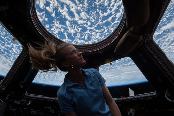
Calling all citizen scientists, geography buffs, fans of the International Space Station and those who love that orbital perspective!
CosmoQuest has a brand new project in coordination with NASA and the Astronomical Society of the Pacific (ASP) where you can help identify features in photographs taken by astronauts from the space station.
The project is called Image Detective. I’ve tried it out, and wow, THIS is a lot of fun!
Now, I absolutely love seeing the images taken of Earth from the ISS, and I routinely follow all the astronauts on board on social media so I can see their latest images. And I also love the concept of regular, everyday people doing science. Plus I’m a big fan of CosmoQuest and their ‘quest’ to bring science to the public.
But still, the setup CosmoQuest has is really great and the process is easy. Citizen scientists are asked to help identify geographic features (natural or human-made) and then determine the location on Earth where the photo is centered.
I found that last part to be the most difficult, but I’ve been known to have trouble reading a map … so I’m hoping that I can improve a bit with more practice.
“The astronauts’ photos of Earth are visually stunning, but more than that, they can be used to study our changing Earth,” said our good friend Dr. Pamela Gay, who is the Director of Technology and Citizen Science at ASP. “From erupting volcanoes, to seasonal flooding, these images document the gradual changes that happen to our landscape. The trick is, we need to make these images searchable, and that means taking the time to sort through, analyze, and label (add metadata) the unidentified images within the database of 1.5 million plus photos.”
The team says that Image Detective spreads the significant work necessary to label all of the images out to citizen scientists across the world.
“This is a unique, powerful, and beautiful image data set that has already yielded excellent research science. But the data set needs the many eyes and minds of citizen scientists to reach its full potential as a publicly available, searchable catalog,” said Dr. Jennifer Grier, a Senior Scientist and Senior Education and Communication Specialist at Planetary Science Institute (PSI) and CosmoQuest’s lead support scientist. “With the additions that citizen scientists as detectives can make, professional research scientists will be able to conduct more research into our changing world, and do so much more effectively.”
Jupiter as seen by the Juno spacecraft during the Perijove 5 pass on March 27, 2017. Processed using raw data. Credit: NASA/JPL-Caltech/SwRI/MSSS/Kevin M. Gill.
The original plans for the Juno mission to Jupiter didn’t include a color camera. You don’t need color images when the mission’s main goals are to map Jupiter’s magnetic and gravity fields, determine the planet’s internal composition, and explore the magnetosphere.
But a camera was added to the manifest, and the incredible images from the JunoCam have been grabbing the spotlight.
As an instrument where students and the public can choose the targets, JunoCam is a “public outreach” camera, meant to educate and captivate everyday people.
“The whole endeavor of JunoCam was to get the public to participate in a meaningful way,” said Candy Hansen, Juno co-investigator at the Planetary Science Institute in Tucson, Arizona, speaking at a press conference last week to showcase Juno’s science and images.
And participate they have. Hundreds of ‘amateur’ image processing enthusiasts have been processing raw data from the JunoCam, turning them into stunning images, many reminiscent of a swirling Van Gogh ‘starry night’ or a cloudscape by Monet.
The swirling cloudtops of Jupiter, as seen by Juno during Perijove 5 on March 27, 2017. Credit: NASA/JPL-Caltech/SwRI/MSSS/Sophia Nasr.
“The contributions of the amateurs are essential,” Hansen said. “I cannot overstate how important the contributions are. We don’t have a way to plan our data without the contributions of the amateur astronomers. We don’t have a big image processing team, so we are completely relying on the help of our citizen scientists.”
Jupiter as seen by Juno during Perijove 6 in May, 2017. Credit: NASA/SwRI/MSSS/Gerald Eichstädt / Seán Doran.
Click on this image to have access to a 125 Megapixel upscaled print portrait.
Featured here are images processed by Seán Doran, Sophia Nasr, Kevin Gill and Jason Major. Like hundreds of others around the world, they anxiously await for data to arrive to Earth, where it is uploaded to the public Juno website. Then they set to work to turn the data into images.
“What I find the most phenomenal of all is that this takes real work,” Hansen said. “When you download a JunoCam image and process it, it’s not something you do in five minutes. The pictures that we get that people upload back onto our site, they’ve invested hours and hours of their own time, and then generously returned that to us.”
This video shows Juno’s trajectory from Perijove 6, and is based on work by Gerald Eichstädt, compiled and edited by Seán Doran. “This is real imagery projected along orbit trajectory,” Doran explained on Twitter.
Intricate swirls on Jupiter Jupiter, from Juno’s Perijove 6 pass on May 19, 2017. Credit: NASA/JPL-Caltech/SwRI /MSSS/Kevin M. Gill.
Details of Jupiter’s swirling gas clouds, as seen by Juno during the Perijove 6 pass in May, 2017. Credit: NASA / SwRI / MSSS / Gerald Eichstädt / Seán Doran.
JunoCam was built by Malin Space Science Systems, which has cameras on previous missions like the Curiosity Mars Rover, the Mars Global Surveyor and the Mars Color Imager on the Mars Reconnaissance Orbiter. To withstand the harsh radiation environment at Jupiter, the camera required special protection and a reinforced lens.
Whenever new images arrive, many of us feel exactly like editing enthusiast Björn Jónsson:
I never expected I'd ever say this but: The latest @NASAJuno images of Jupiter are the most spectacular images of Jupiter I've ever seen. pic.twitter.com/7HawZ9RSwe
Even the science team has expressed their amazement at these images.
“Jupiter looks different than what we expected,” said Scott Bolton, Juno’s principal investigator at the Southwest Research Institute. “Jupiter from the poles doesn’t look anything like it does from the equator. And the fact the north and south pole don’t look like each other, makes us wonder if the storms are stable, if they going to stay that way for years and years like the the Great Red Spot. Only time will tell us what is true.”
A sequence of images of Jupiter from Juno’s Perijove 6 pass during May, 2017. Credit: NASA / SwRI / MSSS / Gerald Eichstädt / Seán Doran.
Part of what makes these images so stunning is that Juno is closer to Jupiter than any previous spacecraft.
“Juno has an elliptical orbit that brings it between the inner edges of Jupiter’s radiation belt and the planet, passing only 5,000 km above the cloud tops,” Juno Project Manager Rick Nybakken told me in my book ‘Incredible Stories From Space: A Behind-the-Scenes Look at the Missions Changing Our View of the Cosmos.’ “This close proximity to Jupiter is unprecedented, as no other mission has conducted their science mission this close to the planet. We’re right on top of Jupiter, so to speak.”
Juno engineers designed the mission to enable the use of solar panels, which prior to Juno, have never been used on a spacecraft going so far from the Sun. Juno orbits Jupiter in a way that the solar panels are always pointed towards the Sun and the spacecraft never goes behind the planet. Juno’s orbital design not only enabled an historic solar-powered mission, it also established Juno’s unique science orbit.
White oval on Jupiter during Juno’s Perijove 4 pass on February 2, 2017. Processed from raw data. Credit: NASA/JPL-Caltech/SwRI/MSSS/Kevin M. Gill.
Uncalibrated, processed raw image from Juno’s Perijove 6 pass of Jupiter on May 19, 2017. Credit: NASA/SwRI/MSSS/Jason Major.
Juno spacecraft launched from Cape Canaveral on August 5, 2011. After traveling five years and 1.7 billion miles Juno arrived in orbit at Jupiter on July 4, 2016. The mission will last until at least February 2018, making 11 science orbits around Jupiter, instead of the 32 laps originally planned. Last year, engineers detected a problem with check valves in the propulsion system, and NASA decided to forego an engine burn to move Juno into a tighter 14-day orbit around Jupiter. The current 53.4 day orbit will be maintained, but depending on how the spacecraft responds, NASA could extend the mission another three years to give Juno more flybys near Jupiter.
The next science flyby will occur on July 11, when Juno will get some close-up views of the famous Great Red Spot.
Thanks to everyone who works on these images.
Animation of six images acquired by NASA’s Juno spacecraft on March 27, 2017. Credit: NASA/JPL-Caltech/SwRI/MSSS/Jason Major.
This enhanced color view of Jupiter’s south pole was created by citizen scientist Gabriel Fiset using data from the JunoCam instrument on NASA’s Juno spacecraft. Oval storms dot the cloudscape. Approaching the pole, the organized turbulence of Jupiter’s belts and zones transitions into clusters of unorganized filamentary structures, streams of air that resemble giant tangled strings. The image was taken on Dec. 11, 2016 at 9:44 a.m. PST (12:44 p.m. EST), from an altitude of about 32,400 miles (52,200 kilometers) above the planet’s beautiful cloud tops. Credits: NASA/JPL-Caltech/SwRI/MSSS/Gabriel Fiset
STEVE, as imaged by Dave Markel in the skies of northern Canada.. Copyright: https://instagram.com/davemarkelphoto
Nicknamed Steve, this unusual aurora feature is a 15.5-mile-wide (25 km) ribbon of hot gas flowing westward at about 13,300 mph, more than 600 times faster than the surrounding air. The photo was taken last fall. Copyright: Instagram.com/davemarkelphoto
This remarkable image was captured last fall by Dave Markel, a photographer based in Kamloops, British Columbia. Later, aurora researcher Eric Donovan of the University of Calgary, discovered Markel’s strange ribbon of light while looking through photos of the northern lights on social media. Knowing he’d found something unusual, Donovan worked sifted through data from the European Space Agency’s Swarm magnetic field mission to try and understand the nature of the phenomenon.
Swarm is ESA’s first constellation of Earth observation satellites designed to measure the magnetic signals from Earth’s core, mantle, crust, oceans, ionosphere and magnetosphere, providing data that will allow scientists to study the complexities of our protective magnetic field. Credit: ESA/AOES Medialab
Launched on 22 November 2013, three identical Swarm satellites orbit the Earth measuring the magnetic fields that stem from Earth’s core, mantle, crust and oceans, as well as from the ionosphere and magnetosphere. Speaking at the recent Swarm science meeting in Canada, Donovan explained how this new finding couldn’t have happened 20 years ago when he started to study the aurora.
A beautiful aurora featuring green arcs near the horizon and many parallel rays lights up the northern sky last October. A small meteor appears to the right of center. Credit: Bob King
While the shimmering, eerie, light display of auroras might be beautiful and captivating, they’re also a visual reminder that Earth is connected electrically and magnetically to the Sun. The more we know about the aurora, the greater our understanding of that connection and how it affects everything from satellites to power grids to electrically-induced corrosion of oil pipelines.
“In 1997 we had just one all-sky imager in North America to observe the aurora borealis from the ground,” said Prof. Donovan. “Back then we would be lucky if we got one photograph a night of the aurora taken from the ground that coincides with an observation from a satellite. Now we have many more all-sky imagers and satellite missions like Swarm so we get more than 100 a night.”
The Suomi NPP satellite photographed this view of the aurora on December 22, 2016, when the northern lights stretched across northern Canada. Credit: NASA Earth Observatory image by Jesse Allen / Suomi National Polar-orbiting Partnership. Colorized and labeled by the author
And that’s where sharing photos and observations on social media can play an important role. Sites like the Great Lakes Aurora Hunters and Aurorasaurus serve as clearinghouses for observers to report auroral displays. Aurorasaurus connects citizen scientists to scientists and searches Twitter feeds for instances of the word ‘aurora,’ so skywatchers and scientists alike know the real-time extent of the auroral oval.
At a recent talk, Prof. Donovan met members the popular Facebook group Alberta Aurora Chasers. Looking at their photos, he came across the purple streak Markel and others had photographed which they’d been referring to as a “proton arc.” But such a feature, caused by hydrogen emission in the upper atmosphere, is too faint to be seen with the naked eye. Donovan knew it was something else, but what?Someone suggested “Steve.” Hey, why not?
Aurora researchers now us a network of all-sky cameras and multiple satellites to keep track of the ever-shifting aurora. Click to see the video. Credit: University of Calgary
While the group kept watch for the Steve’s return, Donovan and colleagues looked through data from the Swarm mission and his network of all-sky cameras. Before long he was able to match a ground sighting of streak to an overpass of one of the three Swarm satellites.
“As the satellite flew straight though Steve, data from the electric field instrument showed very clear changes,” said Donovan.
“The temperature 186 miles (300 km) above Earth’s surface jumped by 3000°C and the data revealed a 15.5-mile-wide (25 km) ribbon of gas flowing westwards at about 6 km/second compared to a speed of about 10 meters/second either side of the ribbon. A friend of mine compared it to a fluorescent light without the glass.
Little did I know I’d met Steve back on May 18, 1990 in this remarkable, narrow arc that stretched from the northwestern horizon to the southeastern. To the eye, a “wind” of vague forms pulsed through the arc. The Big Dipper stands vertically at right. Credit: Bob King
It turns out that these high-speed “rivers” of glowing auroral gas are much more common than we’d thought, and that in no small measure because of the efforts of an army of skywatchers and aurora photographers who keep watch for that telltale green glow in the northern sky.
I spoke to Steve’s keeper, Dave Markel, via e-mail yesterday and he described what the arc looked like to his eyes:
“It’s similar to the image just not as intense. It looks like a massive contrail moving rapidly across the sky. This one lasted almost an hour and ran in an arc almost perfectly east to west. I was directly below it but often there are green pickets (parallel streaks of aurora) rising above the streak.”
This is the same May 18, 1990 streak as above but the eastern half. The bright star Arcturus is visible at upper right. Wish I’d had a fisheye! Credit: Bob King
I know whereof Dave speaks because thanks to his photo and Prof. Donovan’s research, I realize I’ve seen and photographed Steve, too! In decades of aurora watching I’ve only seen this rare streak a handful of times. On most of those occasions, there was either no other aurora visible or minor activity in the northern sky. The narrow arc, which lasted for an hour or so, pulsed and flowed with light and occasionally, Markel’s “pickets” were visible. Back in May 1990 I had a camera on hand to get a picture.
Goes to show, you never know what you might see when you poke your head out for a look. Keep a lookout when aurora’s expected and maybe you’ll get to meet Steve, too.
The November 2012 total solar eclipse as seen from Australia. Image credit and copyright: Alan Dyer.
The November 2012 total solar eclipse as seen from Australia. The Eclipse Megamovie project hopes to capture a similar extended view. Image credit and copyright: Alan Dyer/Amazing Sky Photography.
Ready for the “Great American Eclipse?” We’re now less than six months out from the long-anticipated total solar eclipse spanning the contiguous United States from coast-to-coast. And while folks are scrambling to make last minute plans to stand in the path of totality on Monday, August 21st 2017, a unique project named the Eclipse Megamovie 2017 seeks seeks to document the view across the entire path.
The Project: Sponsored by Google’s Making & Science Initiative and led by Scott McIntosh from the National Center for Atmospheric Research’s High Altitude Observatory and Hugh Hudson from the University of California at Berkeley, the Eclipse Megamovie Project seeks to recruit 1,500 observers stationed across the eclipse path from Oregon to South Carolina. Although individual observers will only experience a maximum totality length of 2 minutes and 40 seconds, the complete span of the Eclipse Megamovie will last 90 minutes, compiled using observer images from coast-to-coast.
Getting ready for the Eclipse Megamovie project. Credit: Eclipse Megamovie Project.
“The movie is a tool for scientific exploration,” Hudson said in a recent University of California at Berkeley press release. “We’ll be collecting this level of data for the first time, from millions of observers, and it will be a valuable archive. But we don’t know what we’ll see or what we’ll learn about the interactions between the chromosphere and the corona.”
One portion of the project will have trained volunteers image the Sun from along the eclipse path using DSLRs, while another portion of the project will feature smartphone users imaging totality using a forthcoming Eclipse Megamovie app for a full length lower resolution movie.
Bikers and Baily’s Beads
The only total solar eclipse for 2017, totality for this eclipse occurs along a 114 kilometer-wide path touching on 12 states. Millions live within an easy day drive of the eclipse path, so expect lots of general public interest leading up to eclipse day. August is RV and camping season, so expect camplots to fill up quickly as well. The eclipse also occurs just over a week after the annual Biker’s Rally in Sturgis, South Dakota, affording motorcyclists a chance to stand in the shadow of the Moon en route to the annual pilgrimage.
The last total solar eclipse to cross one of the 50 United States graced Hawaii on July 11th, 1991, and the last time the umbra of the Moon touched down over the lower 48 states was on February 26th, 1979 across the United States northwest. But you have to go all the way back over almost a century ago to June 8th, 1918 to find an eclipse featuring totality which exclusively spanned the United States from sea to shining sea.
Observers have chased after the umbra seeking to extend fleeting totality before. Eclipse chasers documented the January 24th, 1925 eclipse from aloft aboard a dirigible over New York City. On June 30th, 1973, a supersonic Concorde flight chased the umbra of the Moon across northern Africa, extending totality out to 74 minutes.
The team was also on hand to perform a dry run test of the Megamovie Project at this past weekend’s annular eclipse which crossed South America, the Southern Atlantic and Africa and reports that the field test of the promised project app by Mark Bender worked admirably, and the Eclipse Megamovie App should be available to the general public soon.
A mosaic of the 2016 total solar eclipse, depicting the evolution of Baily’s Beads before and after totality. Image credit and copyright: Steed Joy.
What sort of science can such a project offer? What is left to learn from a total solar eclipse after centuries of scientific study? Well, some of the most accurate measurements of the solar diameter and the size and shape of the Sun have been made during solar eclipses. A long movie may also reveal streamers and development of the solar corona, the ethereal pearly white glowing outer atmosphere surrounding the Sun. About half as bright as a Full Moon, we only get a brief glimpse of the corona during totality. Also, the Eclipse Megamovie will get another shot at the project in April 2024, when another eclipse crosses the United States from Texas to Maine.
The Eclipse Megamovie is taking volunteers now. The gear setup required is simple, and you might have what’s needed to image the eclipse laying around already.
Got a tripod-mounted, zoom lens equipped DSLR? Photo by author.
You’ll need a DSLR camera with a sturdy tripod, a zoom or fixed lens of 300mm focal length or better, and an ability to nail down your GPS location and the time to the nearest second. Once the volunteers are selected, training will be provided to include GPS and time stamping images, flat-fielding and more.
Phone apps will readily supply the GPS part. For time, I’d go with with WWV Radio, which broadcasts a continuous audio time hack out of Fort Collins, Colorado. This is in Universal Time, and has an accuracy of better than a second better than online time sources, which occasionally lag due to spurious web connections.
Keep in mind, you’ll be photographing the eclipsed Sun during very brief moments of totality. You’ll need to have approved solar glasses and filters in place during all partial phases leading up to and immediately after the eclipse. The Eclipse Megamovie project also hopes to catch sight of the Bailey’s Beads phenomenon as final streamers of sunlight pour through the lunar valleys, giving the illusion known as the Diamond Ring effect.
An animation of the August 21st, 2017 total solar eclipse. A.T. Sinclair/NASA/GSFC
And us? We’ll be casting our hubris at the Universe and catch the eclipse from Columbia, South Carolina. We’re heeding the advice of veteran eclipse chasers, and simply enjoying our first eclipse, and imaging our second, though we may sneak in a few shots for the Eclipse Megamovie project. Universe Today publisher Fraser Cain and astronomer and AstronomyCast host Pamela Gay will lead a group watching from southern Illinois, and we’ve also heard from many other observers from around the world who’ll be visiting the U.S. the August… where will you be?
And we’ve already got a spot picked out for 2024, as the next total solar eclipse crosses Aroostook County and our hometown of Mapleton, Maine… hey, you can never start planning too early, right?
Get set for an eclipse for the ages, and be sure to contribute to the Eclipse Megamovie Project.
-Read about all eclipses, comets, occultations and more for the year in our guide to 101 Astronomical Events for 2017, free from Universe Today.