We’ve shared the images and a previous timelapse of Earth’s northern hemisphere, but now here’s a breath-taking timelapse of the entire blue (and green!) marble as seen from Russia’s Elektro-L weather-forecasting satellite, orbiting at a geostationary height of about 36,000 km (22,300 miles). This new video was created by James Drake using some of the largest whole disk images of our planet, as each image is 121 megapixels, and the resolution is 1 kilometer per pixel. The satellite’s wide-angle Multichannel Scanning Unit (MSU) takes images every 15-30 minutes, showing the same viewpoint of Earth across progressive times of the day and the images are in four different wavelengths of light — three visible, and one infrared.
Full-disk image of Earth from Russia's Elektro-L satellite. (NTs OMZ)
[/caption]
Unlike most satellite images of Earth, this one was not assembled from multiple swath scans or digitally projected onto a globe model — it’s the full disk of our planet in captured as a single, enormous 121 megapixel image, acquired by Russia’s Elektro-L weather-forecasting satellite.
Like NASA’s GOES satellites, Elektro-L is parked in a geostationary orbit approximately 36,000 km (22,300 miles) above our planet. Unlike NASA’s satellites, however, Elektro-L captures images in near-infrared as well as visible wavelengths, providing detail about not only cloud movement but also vegetation variations. Its wide-angle Multichannel Scanning Unit (MSU) takes images every 15-30 minutes, showing the same viewpoint of Earth across progressive times of the day.
At a resolution of 0.62 miles per pixel, full-size Elektro-L images are some of the most detailed images of Earth acquired by a weather satellite.
Download the full-size image here (100+ megabytes).
Launched aboard a Zenit rocket on January 20, 2011, Elektro-L was the first major spacecraft to be developed in post-Soviet Russia. Parked over Earth at 76 degrees east longitude, Elektro-L provides local and global weather forecasting and analysis of ocean conditions, as well as “space weather” monitoring — measurements of solar radiation and how it interacts with Earth’s magnetic field. Its initial lifespan is projected to be ten years.
A second Elektro-L satellite is anticipated to launch in 2013.
Image credit: Russian Federal Space Agency / Research Center for Earth Operative Monitoring (NTS OMZ). See more images and video from Elektro-L on James Drake’s Planet Earth here. (Tip of the geostationary hat to Jesus Diaz at Gizmodo.)
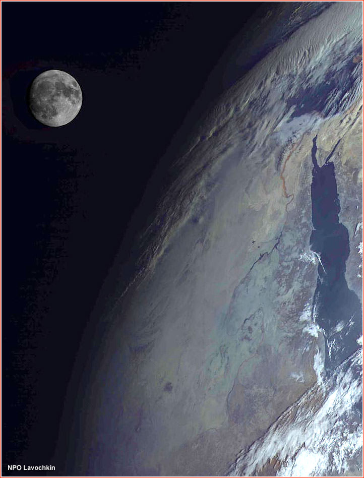
Russia's Elektro-L spacecraft captured this view of the Moon over the Red Sea region of the Earth. Credit: NPO Lavochkin
[/caption]
This stunning picture of the Moon and Earth was taken by Russia’s new Elektro-L spacecraft, a weather-forecasting satellite that launched in January 2011. This is the first major spacecraft developed in post-Soviet Russia, and it is designed to give Russian meteorologists the ability to watch the entire disk of the planet, thanks to the satellite’s position in the geostationary orbit 36,000 kilometers above the equator. The clarity of the images is fantastic, as you can see in another image of just the Earth, below. The Elektro-L is designed to last at least a decade, and will enable local and global weather forecasting, analysis of oceanic conditions, as well as space weather monitoring, such as measurements of solar radiation, properties of Earth’s ionosphere and magnetic field.
On Feb. 26, 2011, at 14:30 Moscow Time, the Elektro-L satellite produced its first breathtaking image of the home planet. Credit: NPO Lavochkin