Videos: Two Different Satellite Views of the Big Snowstorm of 2011
Here's an image from the top animation, the storm as seen on January 31, 2011
To speak in the vernacular of the peasantry, this storm was a whopper. Heavy snow, ice, freezing rain, and frigid wind battered about two thirds of the United States, making it “a winter storm of historic proportions,” said the National Weather Service. This animation—made with images from the NOAA-NASA GOES 13 satellite—shows the giant storm developing and moving across the country between January 31 and February 2. Below is another video view from GOES-East satellite, which includes infrared water vapor imagery from January 29 -February 1, 2011.
And there’s also an update on Cyclone Yasi.
[/caption]
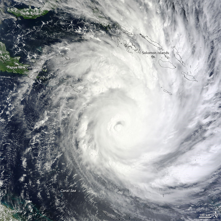
Yasi weakened after coming ashore early on Thursday morning but was still strong enough to produce high winds and tidal surges that sent waves crashing deep into seaside communities. Thankfully, so far no lives have been lost because of this storm. Officials said lives were saved because after days of dire warnings people heeded directions to flee to evacuation centers or bunker themselves at home. Track the storm on WeatherUnderground, and read more on the latest news from Yasi on The Guardian.
Sources: NASA Earth Observatory, SolarWatcher, The Guardian
Recent Posts
China Creates a High-Resolution Atlas of the Moon
Multiple space agencies are looking to send crewed missions to the Moon's southern polar region…
Dinkinesh's Moonlet is Only 2-3 Million Years Old
Last November, NASA's Lucy mission conducted a flyby of the asteroid Dinkinish, one of the…

The Universe Could Be Filled With Ultralight Black Holes That Can't Die
Steven Hawking famously calculated that black holes should evaporate, converting into particles and energy over…
Starlink on Mars? NASA Is Paying SpaceX to Look Into the Idea
NASA has given the go-ahead for SpaceX to work out a plan to adapt its…
Did You Hear Webb Found Life on an Exoplanet? Not so Fast…
The JWST is astronomers' best tool for probing exoplanet atmospheres. Its capable instruments can dissect…
Vera Rubin’s Primary Mirror Gets its First Reflective Coating
First light for the Vera Rubin Observatory (VRO) is quickly approaching and the telescope is…