The Inauguration of President Barack Obama from Space
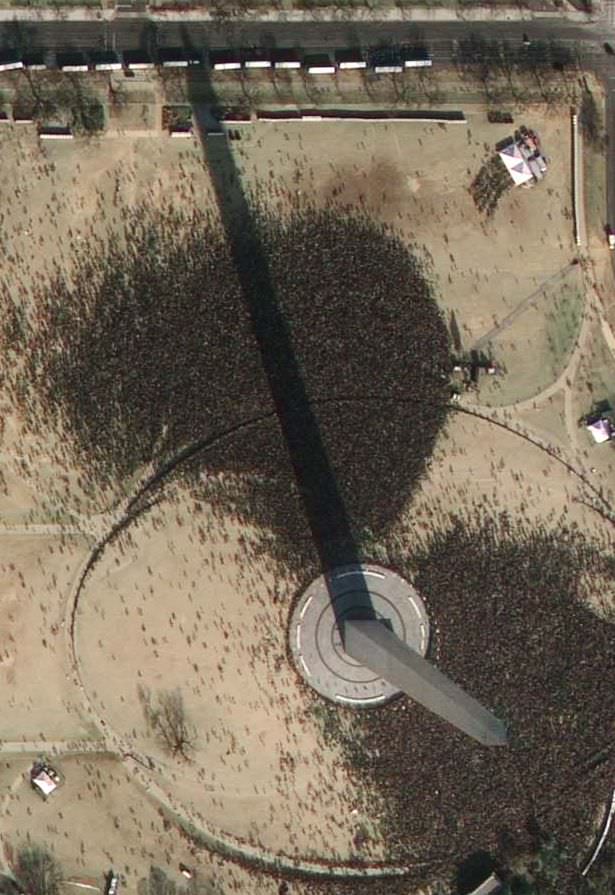
Today's inauguration as seen from over 400 miles high (GeoEye)
[/caption]
Travelling at 17,000 mph at an altitude of 423 miles, the 4,300 lb GeoEye-1 snapped a very high resolution image of Washington D.C. just before Barack Obama became the 44th President of the United States. Looking like crowds of ants vying for space around Capitol Hill and the White House, hundreds of thousands of spectators gathered to watch this historic day unfold…
GeoEye commissioned this orbital photograph in response to numerous media requests. The satellite is able to attain a resolution of 0.41 meters, although this preliminary view has been shrunk by media sources for distribution. It does however, capture a unique view of what is a historic day not only for the US but for the World.
More information about GeoEye-1:
“In August 2008, Google signed a deal with the satellite imagery company GeoEye for exclusive use of the images produced by the company’s new GeoEye-1 satellite. GeoEye-1 was launched on board a United Launch Alliance Delta II rocket from Vandenberg Air Force Base, California, on September 6th 2008. The satellite is currently in a Sun-synchronous orbit, over 400 miles above the surface of Earth, imaging the surface in unprecedented detail. A US government licence actually limits the resolution of available images to 0.5 metres (the camera on GeoEye-1 can attain a resolution of 0.41 metres). GeoEye-1’s competitors can resolve objects down to 0.6 metres at the smallest. The GeoEye products are currently used by Google for several projects, such as Google Earth and Google Maps.”
–Universe Today article, “Google Satellite” Will Have an Orbital View Over Obama’s Inauguration
Source: CNET
Recent Posts
Psyche is Still Sending Data Home at Broadband Speeds
When I heard about this I felt an amused twinge of envy. Over the last…
Uh oh. Hubble's Having Gyro Problems Again
The Hubble Space Telescope has gone through its share of gyroscopes in its 34-year history…

Astronomers Will Get Gravitational Wave Alerts Within 30 Seconds
Any event in the cosmos generates gravitational waves, the bigger the event, the more disturbance.…
Next Generation Ion Engines Will Be Extremely Powerful
During the Space Race, scientists in both the United States and the Soviet Union investigated…
Neutron Stars Could be Capturing Primordial Black Holes
The Milky Way has a missing pulsar problem in its core. Astronomers have tried to…
Japan’s Lunar Lander Survives its Third Lunar Night
Space travel and exploration was never going to be easy. Failures are sadly all too…