The Curiosity rover has now reached its primary target on Mount Sharp on Mars, the mountain in the middle of Gale Crater the rover has been climbing since 2014. This target is not the summit, but a region over 600 meters (2,000 feet) up the mountain that planetary geologists have long anticipated reaching.
Known as the "sulfate-bearing unit," the region is a boundary between the rocks that saw a lot of water in their history and those that didn't; a possible shoreline, if you will. That boundary is already providing insights into Mars' transition from a wet planet to dry, filling in a key gap in the understanding of the planet's history.
"It's official: @MarsCuriosity has reached the sulfate-bearing unit," said planetary scientist Abigail Fraeman on Twitter. Fraeman is the Deputy Project Scientist for the Curiosity mission. "What secrets do these salty rocks contain about the transformation of Mars from watery and habitable to dry and desolate...?"
Loading tweet...
— View on Twitter
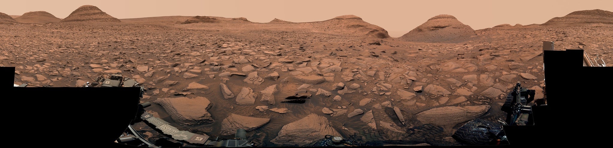
The rover had to travel through a treacherous, narrow sand-lined pass to reach the sought-after region that – from orbital data – appear to be enriched with salty minerals. Those minerals should be able to provide tantalizing clues as to how the Red Planet's climate changed from being more Earth-like to the frozen desert it is today.
Curiosity landed in 2012 and spent about two years studying the region around the base of Mount Sharp. Then the rover began climbing, and along the way finding progressively younger rocks that serve as a record on how Mars has evolved from a wet, habitable planet to a cold desert environment.
The hypotheses is that billions of years ago, the water in Gale Crater – in streams, ponds or even a lake -- left behind the minerals as the water dried up.

Now at the sulfate-bearing unit, the rover team has already used the jackhammering rotary drill at the end of its 2-meter (7-foot) arm to pulverize rock samples for analysis. But they had to choose the rock carefully. Worn brakes on the arm recently led the team to conclude that some harder rocks may require too much hammering to drill safely.
They selected a rock nicknamed "Canaima" for the mission's 36th drill sample.
"As we do before every drill, we brushed away the dust and then poked the top surface of Canaima with the drill. The lack of scratch marks or indentations was an indication that it may prove difficult to drill," said Curiosity's new project manager, Kathya Zamora-Garcia from the Jet Propulsion Laboratory, in a press release. "We paused to consider whether that posed any risk to our arm. With the new drilling algorithm, created to minimize the use of percussion, we felt comfortable collecting a sample of Canaima. As it turned out, no percussion was needed."

The mission's scientists said they look forward to analyzing portions of the sample with the Chemical and Minerology instrument (CheMin) and the Sample Analysis at Mars instrument (SAM).
This region, while providing stunning vistas, also provides challenges for the rover. Sharp rocks can damage Curiosity's wheels (which already filled with holes), and sand can be just as hazardous, potentially causing the rover to get stuck if the wheels lose traction. Rover drivers need to carefully navigate these areas. Additionally, the hills in the area have blocked Curiosity's view of the sky, requiring the rover to be carefully oriented based on where it could point its antennas toward Earth and how long it could communicate with orbiters passing overhead.
The the sulfate minerals were spotted by NASA's Mars Reconnaissance Orbiter years before Curiosity landed in 2012, so scientists have been waiting a long time to see this terrain up close. Soon after arriving, the rover discovered a diverse array of rock types and signs of past water, among them popcorn-textured nodules and salty minerals such as magnesium sulfate (Epsom salt is one kind), calcium sulfate (including gypsum), and sodium chloride (ordinary table salt).

Recently, the Curiosity team celebrated 10 years of their rover on Mars. During the past decade, the rover has acquired over 494,550 images, returned more than 3,100 gigabytes of data to Earth, drilled 36 samples, and scooped up 6 samples. The findings from the mission has yielded over 880 science papers.
