Artificial intelligence can do more than paint planets as bowls of soup. It's now helping researchers acquire better climate change data by teaching Earth observation satellites how to measure ice thickness in the Arctic year-round.
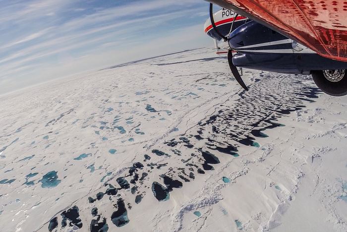
Satellites have been monitoring the Earth's icy north pole for decades now, but the quality of these observations have long been seasonally dependent. In winter, when the ice is solid, cold, and dry, measurement techniques are simple and effective. But things get a lot more challenging in the summer, when melted ponds of water form on the icy surface. From space, these meltwater pools are highly reflective, blinding the satellites' instruments, or making the pools appear to be the open ocean. In these conditions, satellites are unable to distinguish between seawater and melting ice.
In a new paper published in Nature last week, researchers describe how they were able to use artificial intelligence to overcome these limitations. Their work enabled the first ever year-round ice thickness record from a satellite.
The satellite in question is the European Space Agency's CryoSat-2, launched in 2010. CryoSat-2 uses a synthetic aperture radar system that acts as an altimeter: in ideal conditions, it is able to measure its height above the ocean, and above the ice floating on the water. These measurements in comparison allow for the calculation of a thickness estimate. But for five months of the year, the quality of those observations is severely compromised.
To fill the knowledge gap, researchers use a variety of buoys, planes, and vessels to monitor ice levels in the summer, but none of these methods offer the grand-scale coverage a satellite could provide.
To enable CryoSat-2 to continue making useful observations from May to September, when it would typically be ineffective, the team worked with previous satellite data from 2011 to 2020, and computer modeling, to teach the system how to recognize the difference between meltwater and open ocean. This machine learning technique enabled a complete, 12-month ice thickness record, something never before achieved by a spacecraft.

The applications of this new capability are perhaps most directly valuable to shipping, making weather pattern prediction easier, and offering guidance as to when northern sea passages are likely to close for the winter. It will also make these forecasts available much earlier in the season.
In the long term, the data will be useful to climate scientists hoping to understand the processes involved in year-over-year sea level changes.
Michel Tsamados (University College London) was one of the authors of the paper. He explains, "when we use the new ice thickness data in advanced climate models, it will improve both our short-term forecasts for the weather at the mid-latitudes and the long-term forecasts that show what climate we will have in the future."
Learn More:
Jack Landy et al. " A year-round satellite sea-ice thickness record from CryoSat-2. " Nature.
Featured Image: Melting sea ice in the Arctic, photographed from the Alfred Wegener Institute's airborne sea-ice survey IceBird. Credit: Alfred-Wegener-Institute / Esther Horvath.