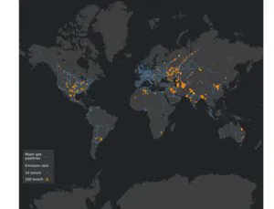
Methane is one of the most important greenhouse gases, despite the overwhelming interest in carbon dioxide emissions as the primary source of climate change. It is hard to track, though, as its sources can range from leaking chemical and gas pipelines to literal farm fields. Now an energy analytics company has a system they believe can track otherwise undocumented methane emissions in a way that could prove helpful in eliminating them altogether.
The company, known as Kayrros, recently published the results of their survey in Science. They used ESA’s Sentinel-5P satellite to monitor the entire world for methane emissions. Monitoring was completed using the TROPOspheric Monitoring Instrument (TROPOMI). Doing so required combing through thousands of daily pictures the satellite captured every day. What they found wasn’t particularly surprising, but it was important.
Credit – Bloomberg Markets & Finance YouTube Channel
Over the course of two years, 1,800 unplanned methane emissions that released more than 25 tons per hour occurred. Of those, 1,200 events came from oil and gas facilities. If these unexpected leaks could be mitigated, it would be the equivalent of removing 20 million cars from the road.
The study mainly focused on six major fossil fuel producers as its research subjects. These included countries on three continents – Russia, Turkmenistan, the USA, Iran, Kazakhstan, and Algeria. Each of these countries would stand to gain economically if they could eliminate these unexpected leaks – with Turkmenistan benefiting the most by saving $6 billion in lost revenues from gas leaks. That is a pretty significant figure for a country whose total GDP is around $45 billion.
Credit – NASA Scientific Visualization Studio YouTube Page
Such monitoring and economic analysis could only have taken place using satellites. Any in-situ or aerial sensor is much less likely to detect the types of emissions the Kayrros data captured. But it does have a defect – satellite data has a very high minimum threshold, meaning that they cannot detect any emissions that release less than 25 tons per house. Those can still be pretty significant, especially as there are likely many more of them than those events detected by TROPOMI. Even the large events it caught made up approximately 10% of the overall methane emissions from oil and gas production.
Knowing there’s a problem is the first step to solving it, and this new satellite analysis method very clearly shows that there is a problem. Whether or not the countries that would most benefit from solving the problem will take it upon themselves to do so is another matter entirely. But if they do, the world will be better off for it.
Learn More:
Kayrros – Groundbreaking study in Science provides first statistical characterization of methane ultra-emitters from oil and gas
Science – Global Assessment of Oil and Gas Methane Ultra-Emitters
ESA – Mapping high-resolution methane emissions from space
Lead Image:
Map of the sources of high-concentration methane leaks.
Credit – Kayrros

