Astronomy Cast Ep. 443: Destroy and Rebuild Pt. 7: Tsunamis
Surf’s up! Today we’re going to be talking about one of the most devastating natural disasters out there: tsunamis. We’re talking huge waves that wreck the seashore. But it turns out, there many ways you can get a tsunami, and one of those has to do with space.
We usually record Astronomy Cast as a live Google+ Hangout on Air every Friday at 1:30 pm Pacific / 4:30 pm Eastern. You can watch here on Universe Today or from the Astronomy Cast Google+ page.
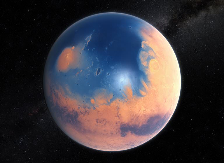
An artist's impression of the ancient Martian ocean. When two meteors slammed into Mars 3.4 billion years ago, they triggered massive, 400 ft. tsunamis that reshaped the coastline. Image: ESO/M. Kornmesser, via N. Risinger
About 3.4 billion years ago, (according to a new study) when the Late Heavy Bombardment had ended, and the first cells resembling prokaryotes were appearing on Earth, two enormous meteoroids slammed into the ancient, frigid ocean on Mars. These impacts generated massive 400 ft. high tsunamis that reshaped the shoreline of the Martian ocean, leaving behind fields of sediments and boulders.
It was long thought that ancient Mars had oceans. Sedimentary deposits discovered in the Martian north by radar in 2012 helped make the case for Martian oceans. 3.4 billion years ago, this ocean covered most of the Northern Martian lowlands. It’s thought that the ocean itself was fed by catastrophic flooding, perhaps fuelled by geothermal activity on Mars at the time.
These catastrophic tsunamis would have dwarfed most Earthly disasters. Waves 120 meters high would have swamped landmarks like the Statue of Liberty (93 m. high), and caused enormous destruction along the Martian coastline. If the research behind this new study stands up to scrutiny, then it will help prove the existence of the ancient Martian ocean.
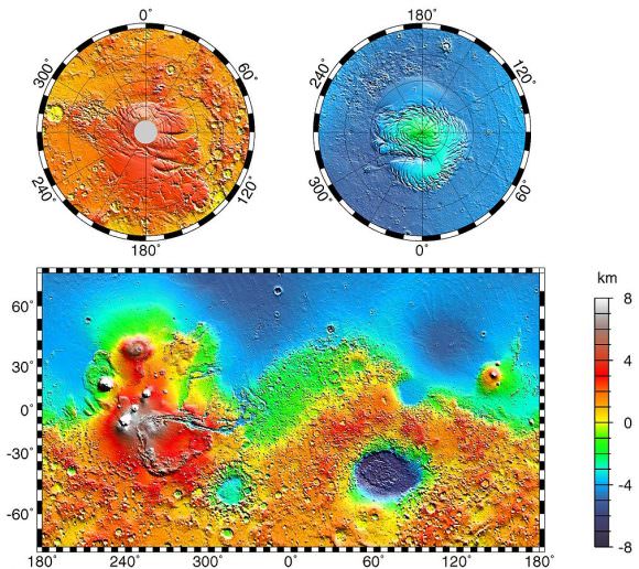
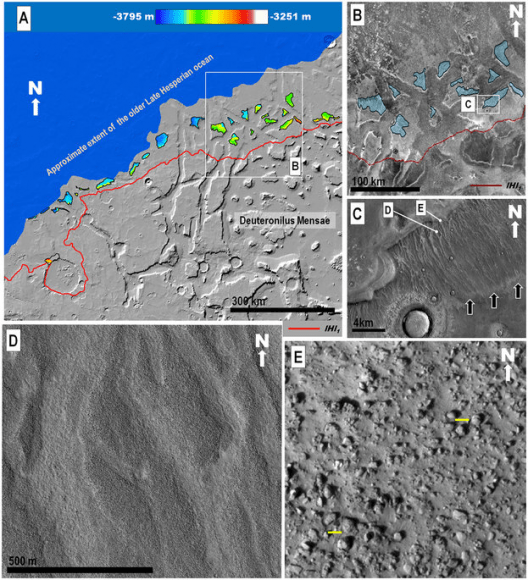
The blue area in the above image is thought to be the location of a primordial ocean Mars. Image: NASA/JPL-Caltech/GSFC – Public Domain
The Martian surface shows the remains of an ancient ocean. In some areas, radar data shows a layer of water-borne sediment on top of a layer of volcanic rock. There’s also evidence of a shoreline, described by some scientists as being like a bathtub ring. The problems is, the shoreline can’t be seen everywhere it should be.
The tsunami hypothesis helps explain this missing shoreline.
According to the new study, led by Alexis Rodriguez, a Mars researcher at the Planetary Science Institute in Tucson Arizona, the tsunamis would have wiped away portions of the coastline, and left behind fields of sediment and boulders, and large backwash channels cut into the Martian surface.
The study is focussed on a specific region on Mars where a highland feature called Arabia Terra abuts the Chryse Planitia lowlands. This area was part of the shoreline of the Martian ocean. In that area, the team behind the study identified two separate geological formations that they say were created by two separate tsunami events.
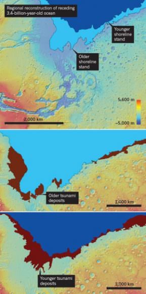
The top image shows the shoreline of the ancient Martian shoreline at two separate times. The bottom images show debris left behind by the two tsunamis. Image: Alexis Rodriguez.
The first formation, and older of the two, looks every bit like a disturbed shoreline. An enormous wave washed over the beach, and in its wake deposited boulders over 10 meters across. Then, as the water drained back down into the ocean, it cut large backwash channels through its debris and boulder field.
A sequence of zoomed in images of the Martian surface in the study. (A) shows distances and elevations of backwash channels. (B) shows some of the channel-scoured, north-sloping highland mesas in blue. (C) shows the channelled surface, and (D) shows them in closer detail. Finally, (E) is zoomed in to show boulders as much as 10 m. in diameter. (Yellow bars are 10m.) Image: A,B:MOLA Science Team, MSS, JPL, NASA. C,D,E: NASA/JPL/University of Arizona
Then, some time passed. Millions of years, probably, until the second meteor hit, triggering another enormous tsunami. But this one behaved a little differently.
Conditions on Mars had changed by then, with temperatures dropping, and glaciers marching across the landscape, gouging out deep valleys on the surface of Mars. When the second tsunami hit the shore, its effect was different.
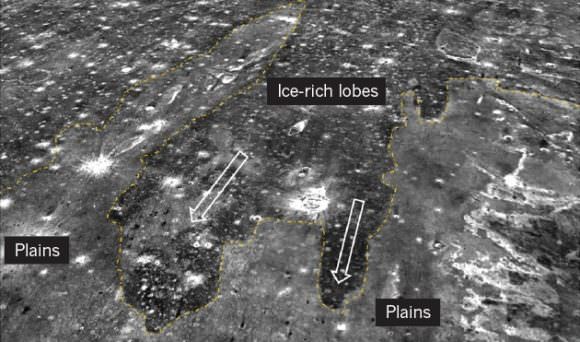
This time, the tsunami was more like an icy slurry, according to the team. Because of the cold temperatures, the icy water froze in place in some areas, before it could wash back into the ocean. The result? Deposits of frozen debris formed in dense lobes on the surface.
This long lobe of dark material on the surface of Mars was left behind when a tsunami of icy flush washed over the Martian coastline, freezing in place before it could wash back into the sea. Image: Alexis Rodriquez
But according to Rodriguez, this is just a snapshot of a process that likely occurred multiple times in the history of Mars. Successive meteors could have caused successive mega-tsunamis that would have repeatedly wiped away evidence of a shoreline. This could have happened as often as every 3 million years.
This study isn’t the knockout blow that proves the existence of a Martian ocean in ancient times. But it is certainly intriguing, and is a reasonable hypothesis that explains missing shorelines.
Rodriguez intends to keep looking for other evidence of tsunamis on the Martian surface. If he finds more, it will help make the case for the meteor-tsunami explanation.
Rodriguez will also be visiting places on Earth that are analogues for the Martian surface of ancient times. This summer he plans on visiting high-altitude, cold, alpine lakes in Tibet, where he hopes to learn something about the processes and geological formations involved.
Even better would be a mission to Mars, to sample the area where the tsunamis came ashore. A group of small craters near the shore that were drenched by the tsunamis is of particular interest to Rodriguez and his team. Martian ocean water could have been trapped there for millions of years. This site could provide evidence about the briny nature of the ancient ocean on Mars, and possibly tell us something about the evolution of life there.
Sarychev volcano, (located in Russia's Kuril Islands, northeast of Japan) in an early stage of eruption on June 12, 2009. Credit: NASA
What if someone were to tell you that there’s a region in the world where roughly 90% of the world’s earthquakes occur. What if they were to tell you that this region is also home to over 75% of the world’s active and dormant volcanoes, and all but 3 of the world’s 25 largest eruptions in the last 11,700 years took place here.
Chances are, you’d think twice about buying real-estate there. But strangely enough, hundreds of millions of people live in this area, and some of the most densely-packed cities in the world have been built atop its shaky faults. We are talking about the Pacific Ring of Fire, a geologically and volcanically active region that stretches from one side of the Pacific to the other.
Definition:
Also known as the circum-Pacific belt, the “Ring of Fire” is a 40,000 km (25,000 mile) horseshoe-shaped basin that is associated with a nearly continuous series of oceanic trenches, volcanic arcs, and volcanic belts and/or plate movements. This ring accounts for 452 volcanoes (active and dormant), stretching from the southern tip of South America, up along the coast of North America, across the Bering Strait, down through Japan, and into New Zealand – with several active and dormant volcanoes in Antarctica closing the ring.
Tectonic Activity:
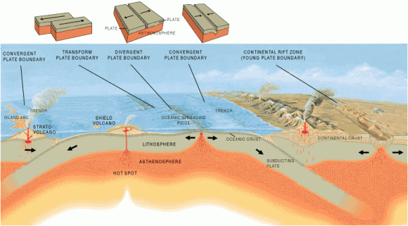
The Ring of Fire is the direct result of plate tectonics and the movement and collisions of lithospheric plates. These plates, which constitute the outer layer of the planet, are constantly in motion atop the mantle. Sometimes they collide, pull apart, or slide alongside each other; resulting in convergent boundaries, divergent boundaries, and transform boundaries.
The Pacific Ring of Fire, a string of volcanic regions extending from the South Pacific to South America. Credit: Public Domain
In the case of the former, subduction zones are often the result, where the heavier plate slips under the lighter plate – forming a deep trench. This subduction changes the dense mantle into buoyant magma, which rises through the crust to the Earth’s surface. Over millions of years, this rising magma creates a series of active volcanoes known as a volcanic arc.
These ocean trenches and volcanic arcs run parallel to one another. For instance, the Aleutian Islands in the U.S. state of Alaska run parallel to the Aleutian Trench. Both geographic features continue to form as the Pacific Plate subducts beneath the North American Plate. Meanwhile, the Andes Mountains of South America run parallel to the Peru-Chile Trench, created as the Nazca Plate subducts beneath the South American Plate.
In the case of divergent boundaries, these are formed when tectonic plates pull apart, forming rift valleys on the seafloor. When this happens, magma wells up in the rift as the old crust pulls itself in opposite directions, where it is cooled by seawater to form new crust. This upward movement and eventual cooling of this magma has created high ridges on the ocean floor over millions of years.
The East Pacific Rise is a site of major seafloor spreading in the Ring of Fire, located on the divergent boundary of the Pacific Plate and the Cocos Plate (west of Central America), the Nazca Plate (west of South America), and the Antarctic Plate. The largest known group of volcanoes on Earth is found underwater along the portion of the East Pacific Rise between the coasts of northern Chile and southern Peru.
The different type of tectonic plate boundaries. Credit: oceanexplorer.noaa.gov
A transform boundary is formed when tectonic plates slide horizontally and parts get stuck at points of contact. Stress builds in these areas as the rest of the plates continue to move, which causes the rock to break or slip, suddenly lurching the plates forward and causing earthquakes. These areas of breakage or slippage are called faults, and the majority of Earth’s faults can be found along transform boundaries in the Ring of Fire.
The San Andreas Fault, stretching along the central west coast of North America, is one of the most active faults on the Ring of Fire. It lies on the transform boundary between the North American Plate, which is moving south, and the Pacific Plate, which is moving north. Measuring about 1,287 kilometers (800 miles) long and 16 kilometers (10 miles) deep, the fault cuts through the western part of the U.S. state of California.
Plate Boundaries:
The eastern section of the Ring of Fire is the result of the Nazca Plate and the Cocos Plate being subducted beneath the westward moving South American Plate. Meanwhile, the Cocos Plate is being subducted beneath the Caribbean Plate, in Central America. A portion of the Pacific Plate along with the small Juan de Fuca Plate are being subducted beneath the North American Plate.
Along the northern portion, the northwestward-moving Pacific plate is being subducted beneath the Aleutian Islands arc. Farther west, the Pacific plate is being subducted along the Kamchatka Peninsula arcs on south past Japan.
The Earth’s Tectonic Plates. Credit: msnucleus.org
The southern portion is more complex, with a number of smaller tectonic plates in collision with the Pacific plate from the Mariana Islands, the Philippines, Bougainville, Tonga, and New Zealand. This portion excludes Australia, since it lies in the center of its tectonic plate.
Indonesia lies between the Ring of Fire along the northeastern islands adjacent to and including New Guinea and the Alpide belt along the south and west from Sumatra, Java, Bali, Flores, and Timor. The famous and very active San Andreas Fault zone of California is a transform fault which offsets a portion of the East Pacific Rise under southwestern United States and Mexico.
Volcanic Activity:
Most of the active volcanoes on The Ring of Fire are found on its western edge, from the Kamchatka Peninsula in Russia, through the islands of Japan and Southeast Asia, to New Zealand. Mount Ruapehu in New Zealand is one of the more active volcanoes in the Ring of Fire, with yearly minor eruptions, and major eruptions occurring about every 50 years.
Krakatau, perhaps better known as Krakatoa, is an island volcano in Indonesia. Krakatoa erupts less often than Mount Ruapehu, but much more spectacularly. Beneath Krakatoa, the denser Australian Plate is being subducted beneath the Eurasian Plate. An infamous eruption in 1883 destroyed the entire island, sending volcanic gas, volcanic ash, and rocks as high as 80 kilometers (50 miles) in the air. A new island volcano, Anak Krakatau, has been forming with minor eruptions ever since.
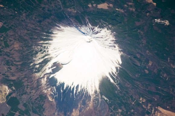
Mount Fuji, Japan, as seen from the ISS. Credit: NASA
Mount Fuji, Japan’s tallest and most famous mountain, is an active volcano in the Ring of Fire. Mount Fuji last erupted in 1707, but recent earthquake activity in eastern Japan may have put the volcano in a “critical state.” Mount Fuji sits at a “triple junction,” where three tectonic plates (the Amur Plate, Okhotsk Plate, and Philippine Plate) interact.
The Ring of Fire’s eastern half also has a number of active volcanic areas, including the Aleutian Islands, the Cascade Mountains in the western U.S., the Trans-Mexican Volcanic Belt, and the Andes Mountains. Mount St. Helens, in the U.S. state of Washington, is an active volcano in the Cascade Mountains.
Below Mount St. Helens, both the Juan de Fuca and Pacific plates are being subducted beneath the North American Plate. Its historic 1980 eruption lasted 9 hours and covered 11 U.S. states with tons of volcanic ash. The eruption caused the deaths of 57 people, over a billion dollars in property damage, and reduced hundreds of square miles to wasteland.
Popocatépetl is one of the most active and dangerous volcanoes in the Ring of Fire, with 15 recorded eruptions since 1519. The volcano lies on the Trans-Mexican Volcanic Belt, which is the result of the small Cocos Plate subducting beneath the North American Plate. Located close to the urban areas of Mexico City and Puebla, Popocatépetl poses a risk to the more than 20 million people that live close enough to be threatened by a destructive eruption.
Map of the Earth showing the relation between fault lines (blue) and zones of volcanic activity (red). Credit: zmescience.com
Earthquakes:
Scientists have known for some time that the majority of the seismic activity occurs along plate boundaries. Hence why roughly 90% of the world’s earthquakes – which is estimated to be around 500,000 a year, one-fifth of which are detectable – occur around the Pacific Rim, where multiple plate boundaries exist.
As a result, earthquakes are a regular occurrence in places like Japan, Indonesia and New Zealand in Asia and the South Pacific; Alaska, British Columbia, California and Mexico in North America; and El Salvador, Guatemala, Peru and Chile in Central and South America. Where fault lines run beneath the ocean, larger earthquakes in these regions also trigger tsunamis.
The most well-known tsumanis to take place in the Ring of Fire include the 2004 Indian Ocean earthquake and tsunami. This was the most devastating tsunami of its kind in modern times, killing around 230,000 people and laying waste to communities throughout Indonesia, Thailand, and Southern Asia.
In 2010, an earthquake triggered a tsunami which caused 4334 confirmed deaths and devastating several coastal towns in south-central Chile, including the port at Talcahuano. The earthquake also generated a blackout that affected 93 percent of the Chilean population.
In 2011, an earthquake off the Pacific coast of Tohoku led to a tsunami that struck Japan and led to 5,891 deaths, 6,152 injuries, and 2,584 people to be declared missing across twenty prefectures. The tsunami also caused meltdowns at three reactors in the Fukushima Daiichi Nuclear Power Plant complex.
The Ring of Fire is a crucial region for many reasons. It serves as one of the main boundary regions for the tectonic plates of over half of the globe. It also affects the lives of millions if not billions of people who live in these regions. For many of the people who live in the Pacific Ring of Fire, the reality of a volcanic eruption or earthquake is commonplace and a challenge they have come to deal with over time.
At the same time, the volcanic activity has also provided many valuable resources, such as rich farmland and the possibility of tapping geothermal activity for heating and electricity. As always, nature gives with one hand and takes with the other!
If you have enjoyed this article there are several others on Universe Today that you will find interesting. Here is one called 10 Interesting Facts About Volcanoes. There is also a great article about plate tectonics.
You can also find some good resources online. There is a companion site for the PBS program Savage Earth that talks about the Ring of Fire. You can also check out the USGS site to see a detailed map of the Pacific Ring of Fire and more detailed information about plate tectonics.
You can also listen to Astronomy Cast. Episode 141 talks about volcanoes.
11 March 2011: The wave from a tsunami crashes over a street in Miyako City, Japan Credit: REUTERS/Mainichi Shimbun
For people living in oceanfront communities, the prospect of a tsunami is a frightening one. Much like earthquakes, volcanoes, hurricanes and tornadoes, tsunamis are one of the most destructive natural forces on the planet. And much like these other phenomena, they require the right conditions to happen and are more common in some areas of the world than others.
Knowing how and when a tsunami will strike has therefore a subject of great interest for scientists over the ages. But for anyone who has lived in certain parts of the world where “tsunami zones” are common – namely Japan and the South Pacific – it is a matter of survival.
Definition: Numerous terms are used in the English language to describe large waves created by the displacement of water, with varying degrees of accuracy. The term tsunami, for example, is literally translated from Japanese to mean “harbor wave”. There are only a few other languages that have an equivalent native word, though similar meanings can be found in Indonesia, Sri Lanka, and the Indian Subcontinent.
The term tidal wave has also been used, which is derived from the most common appearance of a tsunami – an extraordinarily high tidal bore. However, in recent years, the term “tidal wave” has fallen out of favor with the scientific community because tsunami actually have nothing to do with tides, which are produced by the gravitational pull of the moon and sun rather than the displacement of water.
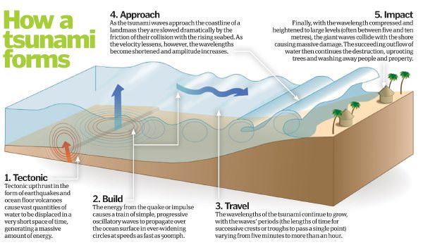
Tsunamis initiate when an earthquake causes the seabed to rupture, which leads to a rapid decrease in sea surface height directly above it. Credit: howitworksdaily.com
The term seismic sea wave also is used to refer to the phenomenon, due to the fact that the waves most often are generated by seismic activity such as earthquakes. However, like “tsunami,” “seismic sea wave” is not a completely accurate term, as forces other than earthquakes – including underwater landslides, volcanic eruptions, underwater explosions, land or ice slumping into the ocean, meteorite impacts, or even sudden changes in weather – can generate such waves by displacing water.
Causes: The principal cause of a tsunami is the displacement of a substantial volume of water or perturbation of the sea. This is usually the result of earthquakes, landslides, volcanic eruptions, glacier calvings, or more rarely by meteorites and nuclear tests. The waves formed in this way are then sustained by gravity.
Tectonic earthquakes trigger tsunamis when the sea floor abruptly deforms and vertically displaces the water above. More specifically, a tsunami can be generated when thrust faults associated with convergent or destructive plate boundaries move abruptly and displace water.
Tsunamis have a small amplitude (wave height) offshore, and a very long wavelength (often hundreds of kilometers long), and only grow in height when they reach shallower water. Once there, the wavelength shortens as the wave encounters resistance, thus increasing the amplitude increases and causing the wave to rears up in a massive tidal bore.
In the 1950s, it was discovered that tsunamis larger than what had previously been believed possible could be caused by giant submarine landslides. These rapidly displace large water volumes, as energy transfers to the water at a rate faster than the water can absorb. Their existence was confirmed in 1958, when a giant landslide in Lituya Bay, Alaska, caused the highest wave ever recorded (524 meters/1700 feet).
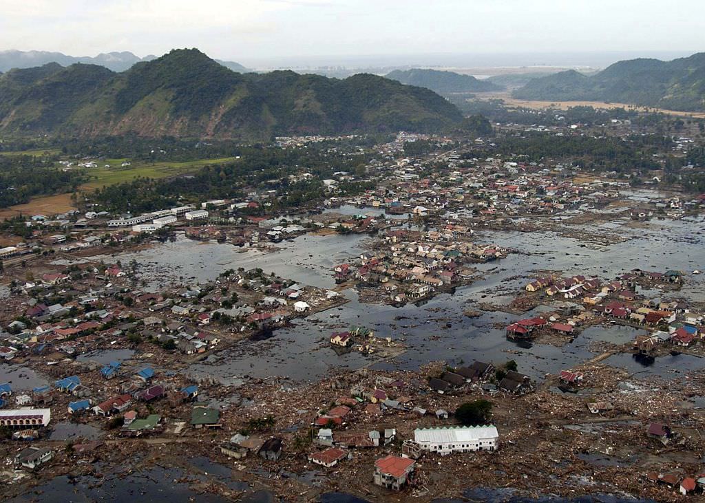
A village near the coast of Sumatra that was devastated by the Tsunami that struck South-East Asia in 2004. Credit: US Navy/Public Domain
In general, landslides generate displacements mainly in the shallower parts of the coastline, such as in closed bays and lakes. But an open oceanic landslide large enough to cause a tsunami across an ocean has not yet happened since the advent of modern seismology, and only rarely in human history.
Meteorological phenomena, such tropical cyclones, can generate a storm surge that will cause sea levels to rise, often in coastal regions. These are what is known as meteotsunamis, which are tsunamis triggered by sudden changes in weather. When such tsunamis reach shore, they rear up in shallows and surge laterally, just like earthquake-generated tsunamis.
Tsunamis can also be triggered by external factors, such as meteors or human intervention. For instance, when a meteor of significant strikes a region of the ocean, the resulting impact is enough to displace high volumes of water, thus triggering a tsunami. There has also been much speculation since World War II of how a nuclear detonations have trigger a tsunami, but all attempts at research (especially in the Pacific) have yielded poor results.
Characteristics and Effects: Tsunamis can travel at well over 800 kilometers per hour (500 mph), but as they approach the coast, wave shoaling compresses the wave and its speed decreases to below 80 kilometers per hour (50 mph). A tsunami in the deep ocean has a much larger wavelength of up to 200 kilometers (120 mi), but diminishes to less than 20 kilometers (12 mi) when it reaches shallow water.
When the tsunami’s wave peak reaches the shore, the resulting temporary rise in sea level is termed run up. Run up is measured in metres above a reference sea level. A large tsunami may feature multiple waves arriving over a period of hours, with significant time between the wave crests.
Tsunamis cause damage by two mechanisms. First, there is the smashing force of a wall of water traveling at high speed, while the second is the destructive power of a large volume of water draining off the land and carrying a large amount of debris with it.
It is often difficult for people to recognize a tsunami in the open ocean because the waves are much smaller further out at sea than they are close to shore. As with earthquakes, several attempts have been made to set up scales of tsunami intensity or magnitude to allow comparison between different events.
Ships try to extinguish a blaze at oil refinery tanks in Ichihara, Chiba Prefecture, after the tsunami that struck in March, 2011. Credit: EPA
The first scales used routinely to measure the intensity of tsunami were the Sieberg-Ambraseys scale, used in the Mediterranean Sea and the Imamura-Iida intensity scale, used in the Pacific Ocean. This latter scale was modified by Soloviev to become the Soloviev-Imamura tsunami intensity scale, which is used in the global tsunami catalogs compiled by the NGDC/NOAA and the Novosibirsk Tsunami Laboratory as the main parameter for the size of the tsunami.
In 2013, following the intensively studied tsunamis in 2004 and 2011, a new 12 point scale was proposed, known as the Integrated Tsunami Intensity Scale (ITIS-2012). This scale was intended to match as closely as possible to the modified ESI2007 and EMS earthquake intensity scales.
Tsunamis throughout History: Japan and the Pacific Ocean may have the longest recorded history of tsunamis, but they are an often underestimated hazard in the Mediterranean Sea region and Europe in general. In his History of the Peloponnesian War (426 BCE), Greek historian Thucydides offered what could be considered the first recorded speculation about the causes of tsunamis – where he argued that earthquakes at sea were the reason for them.
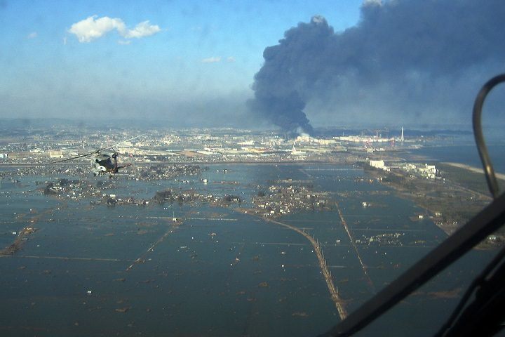
An aerial view of tsunami damage in Tohoku. Credit: US Navy
After the tsunami of 365 CE devastated Alexandria, Roman historian Ammianus Marcellinus described the typical sequence of a tsunami. His descriptions included an earthquake and the sudden retreat of the sea, followed by a gigantic wave.
More modern examples include the 1755 Lisbon earthquake and tsunami (which was caused by activity in the Azores–Gibraltar Transform Fault); the 1783 Calabrian earthquakes, which caused several ten thousand deaths; and the 1908 Messina earthquake and tsunami – which caused 123,000 deaths in Sicily and Calabria and is considered one of the most deadly natural disasters in modern European history.
But by far, the 2004 Indian Ocean earthquake and tsunami was the most devastating of its kind in modern times, killing around 230,000 people and laying waste to communities throughout Indonesia, Thailand, and Southern Asia.
In 2010, an earthquake triggered a tsunami which devastated several coastal towns in south-central Chile, damaged the port at Talcahuano and caused 4334 confirmed fatalities. The earthquake also generated a blackout that affected 93 percent of the Chilean population.
In 2011, an earthquake off the Pacific coast of Tohoku led to a tsunami that struck Japan and led to 5,891 deaths, 6,152 injuries, and 2,584 people to be declared missing across twenty prefectures. The tsunami also caused meltdowns at three reactors in the Fukushima Daiichi Nuclear Power Plant complex.
Tsunamis are a force of nature, without a doubt. And knowing when, where, and how severely they will strike is intrinsic to ensuring that we can limit the damage they do cause.
Universe Today has articles on about tsunamis and causes of tsunamis.
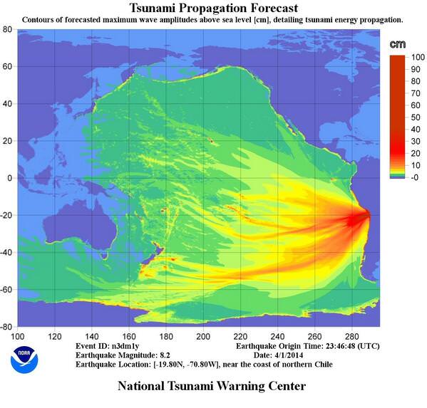
Tsunami propagation forecast following the April 1, 2014 earthquake off the coast of Chile. Credit: NOAA's Pacific Tsunami Warning Center.
An 8.2-magnitude earthquake off the coast of northern Chile on April 1, 2014 was followed by at least a dozen significant aftershocks, including one with a magnitude of 6.2. This activity initially generated tsunami warnings across the Pacific, but the warnings were later canceled except for the coastal regions of Chile and Peru, according to NOAA’s Pacific Tsunami Warning Center.
Tsunami waves of more than 2 meters (6 feet) came ashore on the coast of Pisagua, Chile and 2.13 meter (7-foot) waves were reported in Iquique, Chile, according to the PTWC. The U.S Geological Survey reported the quake major quake was centered offshore about 96 km (60 miles) northwest of Iquique, at a depth of 20 km (12.5 miles).
At the time of this writing, the quake has reportedly caused only minor damage in Chile with two possible casualties, but several people are missing. There was a small landslide, several large fires, along with damaged boats and some flooding in Iquique due to the tsunami, according to Earthquakereport.com.
Chile’s National Emergency Office tweeted Tuesday night that it was asking everyone to evacuate the country’s coastal areas, and reports in the news and on social media said that the evacuations were orderly.
This earthquake follows several weeks of seismic activity in the South American Pacific region. On March 16, a 6.7-magnitude earthquake struck 60 km (37 miles)northwest of Iquique, according to the USGS. A 6.1-magnitude hit the same area one week later.
Chile is one of the most seismically active countries in the world, and is along the so-called “Ring of Fire,” an arc of volcanoes and fault lines circling the Pacific Basic that is prone to frequent earthquakes and volcanic eruptions.
The strongest earthquake ever recorded on Earth also took place happened in Chile. A magnitude-9.5 quake in 1960 killed more than 5,000 people. The most recent large quake in February 2010 hit central and southern Chile with a magnitude of 8.8, followed by a tsunami that left more than 500 dead with $30 billion in damage to property.
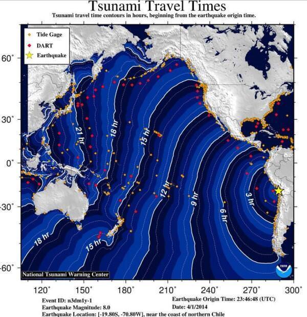
Tsunami waves travel about 800 km per hour, (500 miles per hour). That seems fast, but compared to a seismic wave it is slow. The speed of seismic wave, the P wave (or primary wave, which is the fastest kind of seismic wave) is about 8 km per second, or 30,000 km per hour.
You can compare a tsuanmi wave to the speed of a jet plane.
But while scientists can predict the speed and the direction of tsunamis fairly well, the height at a given location is can be very hard to predict, according to Anne Sheehan from the University of Colorado at Boulder, who spoke to Universe Today for a previous article about the science behind a tsunami.
“For predicting an ensuing tsunami, to have data on the earthquake itself — getting its epicenter located and knowing its size as accurately as possible plays a big role,” she said, “and the USGS plays a big role in getting that information out as quickly as possible.
Update: Here’s an animation from NOAA of the prediction of the tsunami following the April 1 quake in Chile:
Sendai, Japan after the disaster. Satellite image courtesy of GeoEye.
[/caption]
Photos from the GeoEye satellite imaging company from before and after the March 11 earthquake and tsunami in Japan show sobering views from above of the disaster. Above is the town of Sendai, Japan after the quake, below is how it looked before catastrophe struck.
Arahama, Japan before the disaster. Satellite image courtesy of GeoEye.
See more below.
The Sendai Airport after the disaster. Satellite image courtesy of GeoEye.The Sendai Airport in August of 2010. Satellite image courtesy of GeoEye.Yuriage, Japan on March 12, 2011. Satellite image courtesy of GeoEye.Yuriage, Japan on April 4, 2010. Satellite image courtesy of GeoEye.Sendai, Japan on March 12, 2011. Satellite image courtesy of GeoEye.Sendai, Japan on April 4, 2010. Satellite image courtesy of GeoEye.Ishinomaki, Japan on March 12, 2011. Satellite image courtesy of GeoEye.Ishinomaki, Japan on April 4, 2010. Satellite image courtesy of GeoEye.
Below is an images from the MODIS Rapid Response System, which is producing twice-daily images of Japan in response to the disaster.
The Moderate Resolution Imaging Spectroradiometer (MODIS) on NASA’s Aqua satellite took the right image on Mar. 13, 2011, while the MODIS sensor on NASA’s Terra satellite took the left image on Feb 26, 2011. NASA images courtesy the MODIS Rapid Response Team at NASA GSFC.
These two images, from the MODIS instrument on NASA’s Aqua satellite from Mar. 13, 2011 on the right, and the the MODIS sensor on NASA’s Terra satellite from Feb. 26, 2011 on the left before the earthquake and tsunami. Both images were made with infrared and visible light to highlight the presence of water on the ground. Plant-covered land is bright green, bare earth is tan-pink, and snow is blue. The city of Sendai is brown.
At this level of detail, the flooding along the coastline is the most obvious sign of the destructive earthquake and tsunami that struck Japan on March 11. A bright orange-red spot near the city of Sendai is the thermal signature from a fire, also likely caused by the earthquake. The photo-like true-color version of the image shows a plume of black smoke extending east over the ocean.
The German Aerospace Center (Deutsches Zentrum fur Luft- und Raumfahrt; DLR) is responding through its Center for Satellite Based Crisis Information (Zentrum fur Satellitengestutzte Kriseninformation; ZKI), based at its site in Oberpfaffenhofen, and provided the image below.
Japan's Coastline Before and After the Tsunami These images show the effects of the tsunami on Japan's coastline. The image on the left was taken on Sept. 5, 2010; the image on the right was taken on March 12, 2011, one day after an earthquake and resulting tsunami struck the island nation. Image Credit: German Aerospace Center (DLR)/Rapid Eye
Model projections of wave heights from the Japan quake on Friday. Image from NOAA. Click image for higher resolution.
The massive magnitude 8.9 earthquake that struck off the east coast Japan’s main island on March 11, 2011 set in motion a fierce tsunami that may have claimed thousands of lives, and sent tsunami warnings all across the Pacific basin, thousands of kilometers away from the quake’s epicenter. How do earthquakes trigger such enormous tsunami events, and how can scientists predict where these massive waves might travel? Universe Today talked with Anne Sheehan, who is a professor of geological sciences at University of Colorado at Boulder, and is also affiliated with the Cooperative Institute for Research in Environmental Sciences, as well as getting input from David Admiraal, an associate professor of Engineering at the University of Nebraska Lincoln.
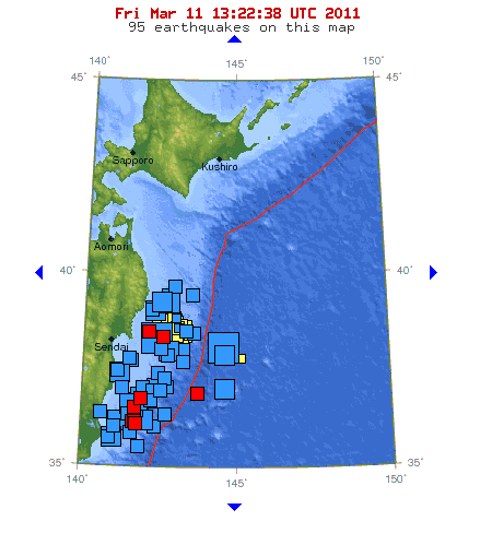
Earthquake map from the USGS of recent quake activity around Japan. Credit: USGS
[/caption]
An 8.9-magnitude earthquake struck off the coast of northern Japan on March 11, one of the strongest to ever hit Japan. The massive quake has triggered tsunamis not only in Japan, but around the Pacific Basin. Walls of water and debris have inundated coastal areas of Japan, and tsunami warnings were issued for at least 20 countries and numerous Pacific islands, including coastal Russia, the western coast of Canada and the US, the Marcus Islands, Taiwan, Guam and the Hawaiian Islands, where a full coastal evactuation has been taking place throughout early Friday morning. Strong aftershocks, as strong as 6.5-magnitude continue to shake the region, (the latest U.S. Geological Survey map, above, shows 95 recent quakes in the area) and at least one nuclear power plant in Japan may be encountering problems. Images coming from Japan show widespread damage from both the quakes and the tsunamis.
The USGS reported that the epicenter of the earthquake was 373 kilometers (231 miles) northeast of Tokyo and 130 km (80 miles) east of Sendai, Honshu. Police reports from Sendai say that so 200-300 bodies have been recovered, but the total death toll will likely be much, much higher. Reports say this is the 6th largest earthquake ever monitored, and the largest in Japan in over 140 years.
Tokyo did not suffer much damage, but in northern Japan, many areas were devastated. Compounding the damage was a wall of water that rushed inland of the island nation, leveling houses and washing away boats, cars and other debris. Click here to see some shocking images from the New York Times.
Reports says Japan is evacuating thousands of people from nearby a nuclear power plant, but the current condition of the reactor core is unknown at this time. Four reactors are located near the Earthquake area. The reactors were shut down, and no leaks have been found so far, but the cooling system for the reactors may not be working correctly.
Reports via Twitter say the roof may have collapsed at JAXA Tsukuba Space Center.
Tsunami waves have now begun to wash ashore in the Hawaiian Islands. The first waves are not necessarily the strongest; waves are predicted to be 2-3 meters (6-8 ft.) in Hawaii. Tsunamis are very hard to predict, and the USGS says wave heights can vary widely.


 on NASA’s Aqua satellite took the right image on Mar. 13, 2011, while the MODIS sensor on NASA’s Terra satellite took the left image on Feb 26, 2011. NASA images courtesy the MODIS Rapid Response Team at NASA GSFC.")
/Rapid Eye")