
[/caption]
Update: Good news: The latest bulletin from the Pacific Tsunami Warning Center, as of 13:00 UTC has canceled the tsunami watch. See here fore more details.
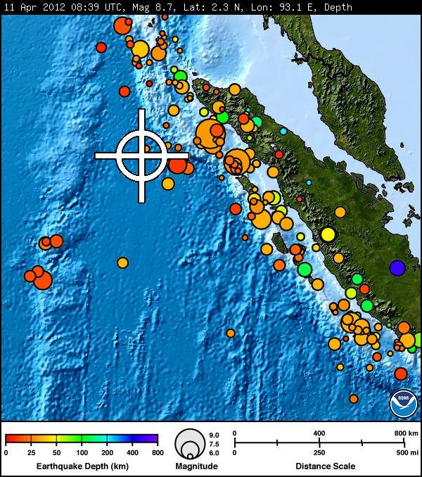
An Indian-ocean-wide tsunami watch is in effect after a massive earthquake off the coast of Indonesia. The quake had a preliminary magnitude of 8.7, and the U.S. Geological Survey said it was centered 32 km (20 miles) beneath the ocean floor about 191 km (308 miles) from the provincial capital of Banda Aceh, the westernmost province in Indonesia. Major aftershocks have occurred, some with magnitudes as high as 8.3.
The tsunami watch area is now reduced from the first reports, as the USGS said the earthquake “moved horizontally, not vertically” but initially included Indonesia, India, Sri Lanka, the Maldives and parts of the UK. A tsunami watch means there is the potential for a tsunami, not that one is imminent.
The earthquake took place at 08:39 UTC on April 11, at 2.3 degrees north and 93.1 degrees east, off the west coast of Northern Sumatra. Reports from Reuters and AP now say that although measurable, the tsunami “does not look major,” officials said.
The Washington Post reported early after the initial quake that a wave measuring less than 30 inches (80 centimeters) high, rolled to Indonesia’s coast, and first reports said there were no other signs of serious damage. But then an 8.2-magnitude aftershock hit, and another tsunami warning was issued, and people along the western coast of Sumatra island and the Mentawai islands were told to stay clear of coasts.
The latest from the Pacific Tsunami Warning Center reports these measurements for tsunami wave activity:
GAUGE LOCATION LAT LON TIME AMPL PER
——————- —– —— —– ————— —–
TRINCONMALEE LK 8.6N 81.2E 1116Z 0.04M / 0.1FT 18MIN
COCOS ISLAND AU 12.1S 96.9E 1102Z 0.08M / 0.3FT 18MIN
TELUKDALAM ID 0.6N 97.8E 1045Z 0.19M / 0.6FT 10MIN
SABANG ID 5.8N 95.3E 1010Z 0.36M / 1.2FT 06MIN
MEULABOH ID 4.1N 96.1E 1007Z 1.06M / 3.5FT 12MIN
DART 23401 8.9N 88.5E 0956Z 0.03M / 0.1FT 06MIN
We’ll provide more information as it becomes available.