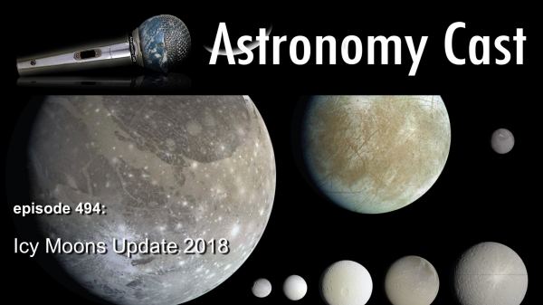
Thanks to Cassini and other spacecraft, we’ve learned a tremendous amount about the icy worlds in the Solar System, from Jupiter’s Europa to Saturn’s Enceladus, to Pluto’s Charon. Geysers, food for bacteria, potential oceans under the ice and more. What new things have we learned about these places?
We usually record Astronomy Cast every Friday at 3:00 pm EST / 12:00 pm PST / 20:00 PM UTC. You can watch us live on AstronomyCast.com, or the AstronomyCast YouTube page.
If you would like to join the Weekly Space Hangout Crew, visit their site here and sign up. They’re a great team who can help you join our online discussions!
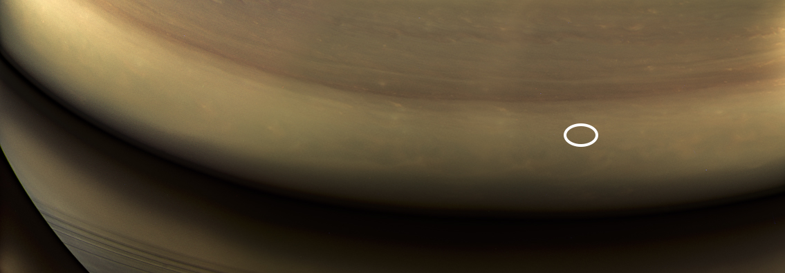
The site of the Cassini probe's crash in Saturn's atmosphere, circled in white. Credit: NASA/JPL-Caltech/Space Science Institute
On September 15th, 2017, after nearly 20 years in service, the Cassini spacecraft ended its mission by plunging into the atmosphere of Saturn. During the 13 years it spent in the Saturn system, this probe revealed a great deal about the gas giant, its rings, and its systems of moons. As such, it was a bittersweet moment for the mission team when the probe concluded its Grand Finale and began descending into Saturn’s atmosphere.
Even though the mission has concluded, scientists are still busy poring over the data sent back by the probe. These include a mosaic of the final images snapped by Cassini’s cameras, which show the location of where it would enter Saturn’s atmosphere just hours later. The exact spot (shown above) is indicated by a white oval, which was on Saturn’s night side at the time, but would later come around to be facing the Sun.
From the beginning, the Cassini mission was a game-changer. After reaching the Saturn system on July 1st, 2004, the probe began a series of orbits around Saturn that allowed it conduct close flybys of several of its moons. Foremost among these were Saturn’s largest moon Titan and its icy moon Enceladus, both of which proved to be a treasure trove of scientific data.
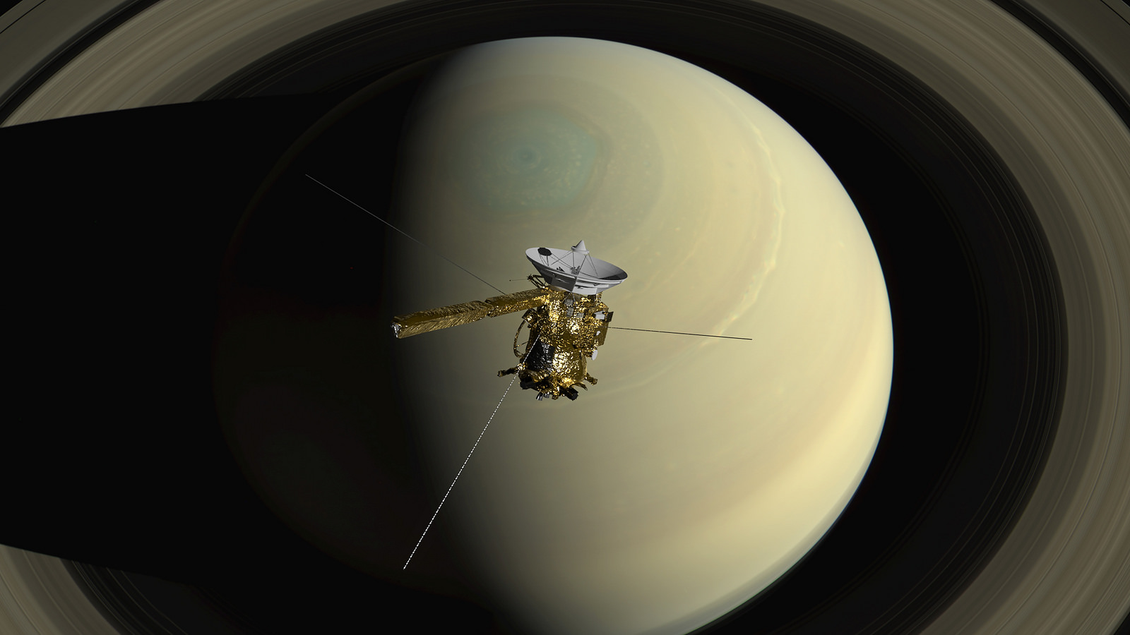
Artist’s impression of the Cassini spacecraft orbiting Saturn. Credit: NASA/JPL-Caltech/Space Science Institute
On Titan, Cassini revealed evidence of methane lakes and seas, the existence of a methanogenic cycle (similar to Earth’s hydrological cycle), and the presence of organic molecules and prebiotic chemistry. On Enceladus, Cassini examined the mysterious plumes emanating from its southern pole, revealing that they extended all the way to the moon’s interior ocean and contained organic molecules and hydrated minerals.
These findings have inspired a number of proposals for future robotic missions to explore Titan and Enceladus more closely. So far, proposals range from exploring Titan’s surface and atmosphere using lightweight aerial platforms, balloons and landers, or a dual quadcopter. Other proposals include exploring its seas using a paddleboat or a even a submarine. And alongside Europa, there are scientists clamoring for a mission to Enceladus and other “Ocean Worlds” to explore its plumes and maybe even its interior ocean.
Beyond that, Cassini also revealed a great deal about Saturn’s atmosphere, which included the persistent hexagonal storm that exists around the planet’s north pole. During its Grand Finale, where it made 22 orbits between Saturn and its rings, the probe also revealed a great deal about the three-dimensional structure and dynamic behavior of the planet’s famous system of rings.
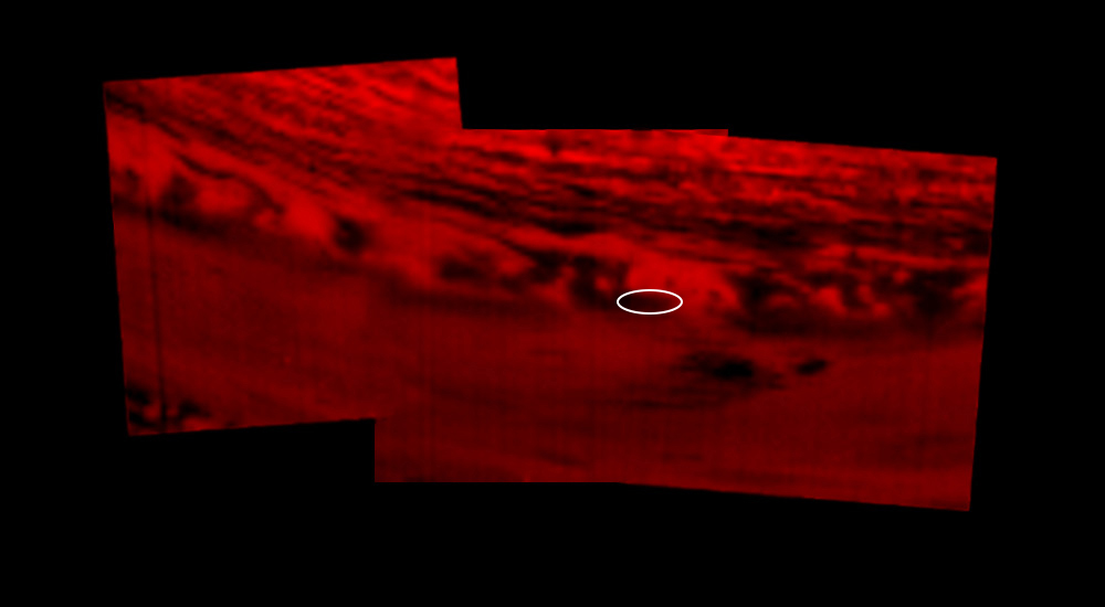
This montage of images, made from data obtained by Cassini’s visual and infrared mapping spectrometer, shows the location on Saturn where the NASA spacecraft entered Saturn’s atmosphere on Sept. 15, 2017. Credits: NASA/JPL-Caltech/University of Arizona
It is only fitting then that the Cassini probe would also capture images of the very spot where its mission would end. The images were taken by Cassini’s wide-angle camera on Sept. 14th, 2017, when the probe was at a distance of about 634,000 km (394,000 mi) from Saturn. They were taken using red, green and blue spectral filters, which were then combined to show the scene in near-natural color.
The resulting image is not dissimilar from another mosaic that was released on September 15th, 2017, to mark the end of the Cassini mission. This mosaic was created using data obtained by Cassini’s visual and infrared mapping spectrometer, which also showed the exact location where the spacecraft would enter the atmosphere – 9.4 degrees north latitude by 53 degrees west longitude.
The main difference, of course, is that this latest mosaic benefits from the addition of color, which provides a better sense of orientation. And for those who are missing the Cassini mission and its regular flow of scientific discoveries, its much more emotionally fitting! While we may never be able to find the wreckage buried inside Saturn’s atmosphere, it is good to know where its last known location was.
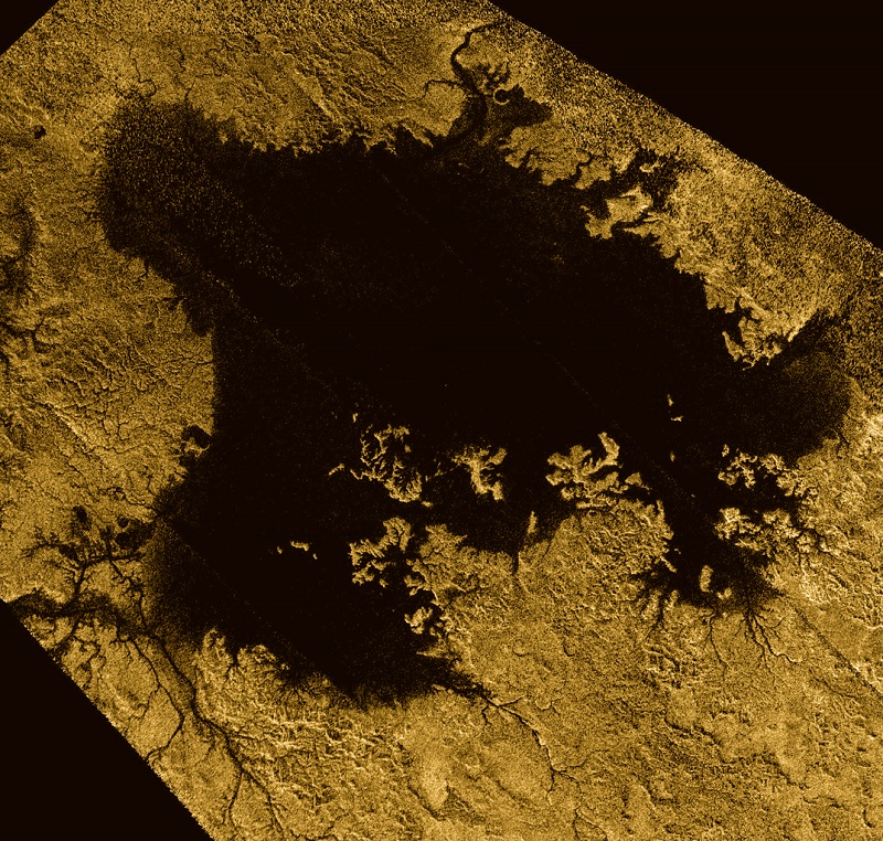
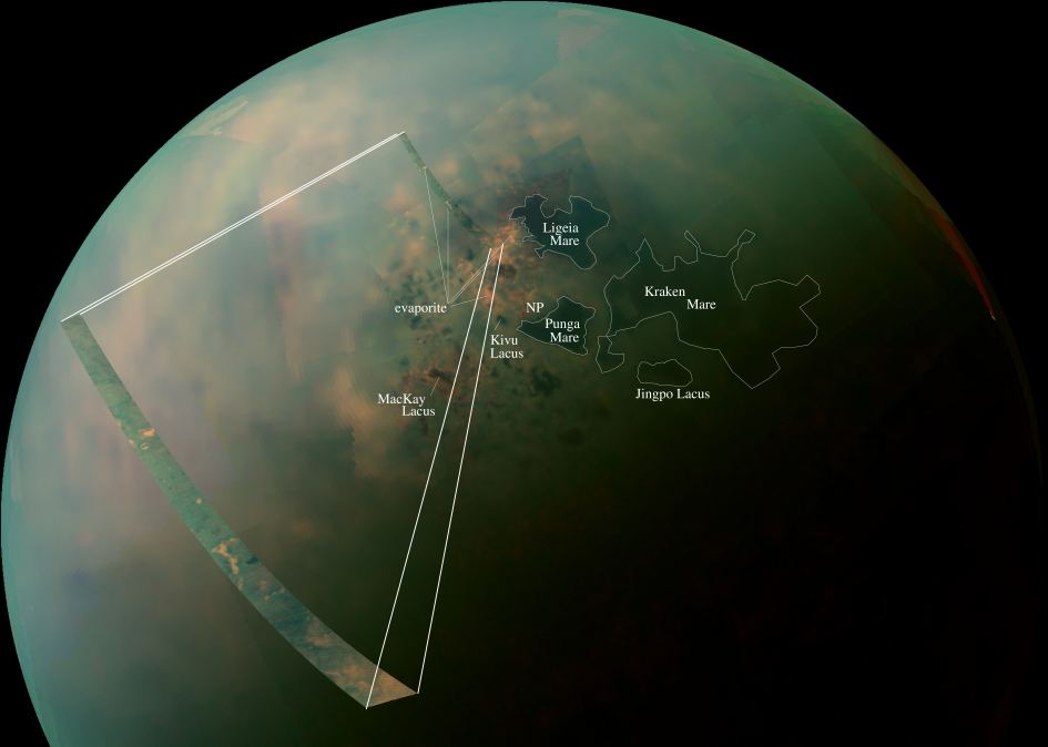
Ligeia Mare, shown in here in data obtained by NASA's Cassini spacecraft, is the second largest known body of liquid on Saturn's moon Titan. It is filled with liquid hydrocarbons, such as ethane and methane, and is one of the many seas and lakes that bejewel Titan's north polar region. Credit: NASA/JPL-Caltech/ASI/Cornell
Thanks to the Cassini mission, we have learned some truly amazing things about Saturn and its largest moon, Titan. This includes information on its dense atmosphere, its geological features, its methane lakes, methane cycle, and organic chemistry. And even though Cassini recently ended its mission by crashing into Saturn’s atmosphere, scientists are still pouring over all of the data it obtained during its 13 years in the Saturn system.
And now, using Cassini data, two teams led by researchers from Cornell University have released two new studies that reveal even more interesting things about Titan. In one, the team created a complete topographic map of Titan using Cassini’s entire data set. In the second, the team revealed that Titan’s seas have a common elevation, much like how we have a “sea level” here on Earth.
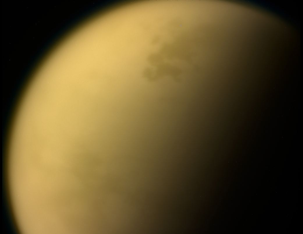
This true-color image of Titan, taken by the Cassini spacecraft, shows the moon’s thick, hazy atmosphere. Credit: NASA
In the first paper, the authors described how topographic data from multiple sources was combined to create a global map of Titan. Since only about 9% of Titan was observed with high-resolution topography (and 25-30% in lower resolution) the remainder of the moon was mapped with an interpolation algorithm. Combined with a global minimization process, this reduced errors that would arise from such things as spacecraft location.
The map revealed new features on Titan, as well as a global view of the highs and lows of the moon’s topography. For instance, the maps showed several new mountains which reach a maximum elevation of 700 meters (about 3000 ft). Using the map, scientists were also able to confirm that two locations in the equatorial regions are depressions that could be the result of ancient seas that have since dried up or cryovolcanic flows.
The map also suggests that Titan may be more oblate than previously thought, which could mean that the crust varies in thickness. The data set is available online, and the map which the team created from it is already proving its worth to the scientific community. As Professor Corlies explained in a Cornell press release:
“The main point of the work was to create a map for use by the scientific community… We’re measuring the elevation of a liquid surface on another body 10 astronomical units away from the sun to an accuracy of roughly 40 centimeters. Because we have such amazing accuracy we were able to see that between these two seas the elevation varied smoothly about 11 meters, relative to the center of mass of Titan, consistent with the expected change in the gravitational potential. We are measuring Titan’s geoid. This is the shape that the surface would take under the influence of gravity and rotation alone, which is the same shape that dominates Earth’s oceans.”
False-color mosaic of Titan’s northern lakes, made from infrared data collected by NASA’s Cassini spacecraft. Credit: NASA
Looking ahead, this map will play an important role when it comes tr scientists seeking to model Titan’s climate, study its shape and gravity, and its surface morphology. In addition, it will be especially helpful for those looking to test interior models of Titan, which is fundamental to determining if the moon could harbor life. Much like Europa and Enceladus, it is believed that Titan has a liquid water ocean and hydrothermal vents at its core-mantle boundary.
The second study, which also employed the new topographical map, was based on Cassini radar data that was obtained up to just a few months before the spacecraft burned up in Saturn’s atmosphere. Using this data, Assistant Professor Hayes and his team determined that Titan’s seas follow a constant elevation relative to Titan’s gravitational pull. Basically, they found that Titan has a sea level, much like Earth. As Hayes explained:
“We’re measuring the elevation of a liquid surface on another body 10 astronomical units away from the sun to an accuracy of roughly 40 centimeters. Because we have such amazing accuracy we were able to see that between these two seas the elevation varied smoothly about 11 meters, relative to the center of mass of Titan, consistent with the expected change in the gravitational potential. We are measuring Titan’s geoid. This is the shape that the surface would take under the influence of gravity and rotation alone, which is the same shape that dominates Earth’s oceans.”
This common elevation is important because liquid bodies on Titan appear to be connected by something resembling an aquifer system. Much like how water flows underground through porous rock and gravel on Earth, hydrocarbons do the same thing under Titan’s icy surface. This ensures that there is transference between large bodies of water, and that they share a common sea level.
Artist concept of Cassini’s last moments at Saturn. Credit: NASA/JPL.
“We don’t see any empty lakes that are below the local filled lakes because, if they did go below that level, they would be filled themselves,” said Hayes. “This suggests that there’s flow in the subsurface and that they are communicating with each other. It’s also telling us that there is liquid hydrocarbon stored on the subsurface of Titan.”
Meanwhile, smaller lakes on Titan appear at elevations several hundred meters above Titan’s sea level. This is not dissimilar to what happens on Earth, where large lakes are often found at higher elevations. These are known as “Alpine Lakes”, and some well-known examples include Lake Titicaca in the Andes, Lakes Geneva in the Alps, and Paradise Lake in the Rockies.
Last, but not least, the study also revealed the vast majority of Titan’s lakes are found within sharp-edged depressions that are surrounded by high ridges, some of which are hundreds of meters high. Here too, there is a resemblance to features on Earth – such as the Florida Everglades – where underlying material dissolves and causes the surface to collapse, forming holes in the ground.
The shape of these lakes indicate that they may be expanding at a constant rate, a process known as uniform scarp retreat. In fact, the largest lake in the south – Ontario Lacus – resembles a series of smaller empty lakes that have coalesced to form a single feature. This process is apparently due to seasonal change, where autumn in the southern hemisphere leads to more evaporation.
While the Cassini mission is no longer exploring the Saturn system, the data it accumulated during its multi-year mission is still bearing fruit. Between these latest studies, and the many more that will follow, scientists are likely to reveal a great deal more about this mysterious moon and the forces that shape it!
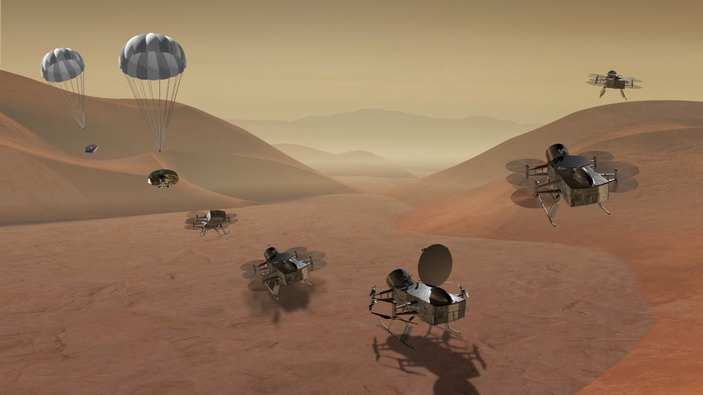
In this illustration, the Dragonfly helicopter drone is descending to the surface of Titan. Image: NASA
The only thing cooler than sending a helicopter drone to explore Titan is sending a nuclear powered one to do the job. Called the “Dragonfly” spacecraft, this helicopter drone mission has been selected as one of two finalists for NASA’s robotic exploration missions planned for the mid 2020’s. NASA selected the Dragonfly mission from 12 proposals they were considering under their New Horizons program.
Titan is Saturn’s largest moon, and is a primary target in the search for life in our Solar System. Titan has liquid hydrocarbon lakes on its surface, a carbon-rich chemistry, and sub-surface oceans. Titan also cycles methane the way Earth cycles water.
This true-color image of Titan, taken by the Cassini spacecraft, shows the moon’s thick, hazy atmosphere. Image: By NASA – http://photojournal.jpl.nasa.gov/catalog/PIA14602, Public Domain, https://commons.wikimedia.org/w/index.php?curid=44822294
Dragonfly would fulfill its mission by hopping around on the surface of Titan. Once an initial landing site is selected on Titan, Dragonfly will land there with the assistance of a ‘chute. Dragonfly will spend periods of time on the ground, where it will charge its batteries with its radioisotope thermoelectric generator. Once charged, it would then fly for hours at time, travelling tens of kilometers during each flight. Titan’s dense atmosphere and low gravity (compared to Earth) allows for this type of mission.
During these individual flights, potential landing sites would be identified for further scientific work. Dragonfly will return to its initial landing site, and only visit other sites once they have been verified as safe.
Dragonfly is being developed at the Johns Hopkins Applied Physics Laboratory (JHAPL.) It has a preliminary design weight of 450 kg. It’s a double quad-copter design, with four sets of dual rotors.
“Titan is a fascinating ocean world,” said APL’s Elizabeth Turtle, principal investigator for Dragonfly. “It’s the only moon in the solar system with a dense atmosphere, weather, clouds, rain, and liquid lakes and seas—and those liquids are ethane and methane. There’s so much amazing science and discovery to be done on Titan, and the entire Dragonfly team and our partners are thrilled to begin the next phase of concept development.”
The science objectives of the Dragonfly mission center around prebiotic organic chemistry and habitability on Titan. It will likely have four instruments:
Being chosen as a finalist has the team behind Dragonfly excited for the project. “This brings us one step closer to launching a bold and very exciting space exploration mission to Titan,” said APL Director Ralph Semmel. “We are grateful for the opportunity to further develop our New Frontiers proposals and excited about the impact these NASA missions will have for the world.”
Exploring Titan holds a daunting set of challenges. But as we’ve seen in recent years, NASA and its partners have the capability to meet those challenges. The JHAPL team behind Dragonfly also designed and built the New Horizons mission to Pluto and the Kuiper Belt object 2014 MU69. Their track record of success has everyone excited about the Dragonfly mission.
The Dragonfly mission, and the other finalist—the Comet Astrobiology Exploration Sample Return being developed by Cornell University and the Goddard Space Flight Center—will each receive funding through the end of 2018 to work on the concepts. In the Spring of 2019, NASA will select one of them and will fund its continued development.
Dragonfly is part of NASA’s New Frontiers program. New Frontiers missions are planetary science missions with a cap of approximately $850 million. New Frontiers missions include the Juno mission to Jupiter, the Osiris-REx asteroid sample-return missions, and the aforementioned New Horizons mission to Pluto.
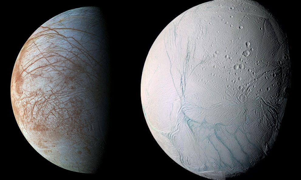
The moons of Europa and Enceladus, as imaged by the Galileo and Cassini spacecraft. Credit: NASA/ESA/JPL-Caltech/SETI Institute
In the hunt for extra-terrestrial life, scientists tend to take what is known as the “low-hanging fruit approach”. This consists of looking for conditions similar to what we experience here on Earth, which include at oxygen, organic molecules, and plenty of liquid water. Interestingly enough, some of the places where these ingredients are present in abundance include the interiors of icy moons like Europa, Ganymede, Enceladus and Titan.
Whereas there is only one terrestrial planet in our Solar System that is capable of supporting life (Earth), there are multiple “Ocean Worlds” like these moons. Taking this a step further, a team of researchers from the Harvard Smithsonian Center for Astrophysics (CfA) conducted a study that showed how potentially-habitable icy moons with interior oceans are far more likely than terrestrial planets in the Universe.
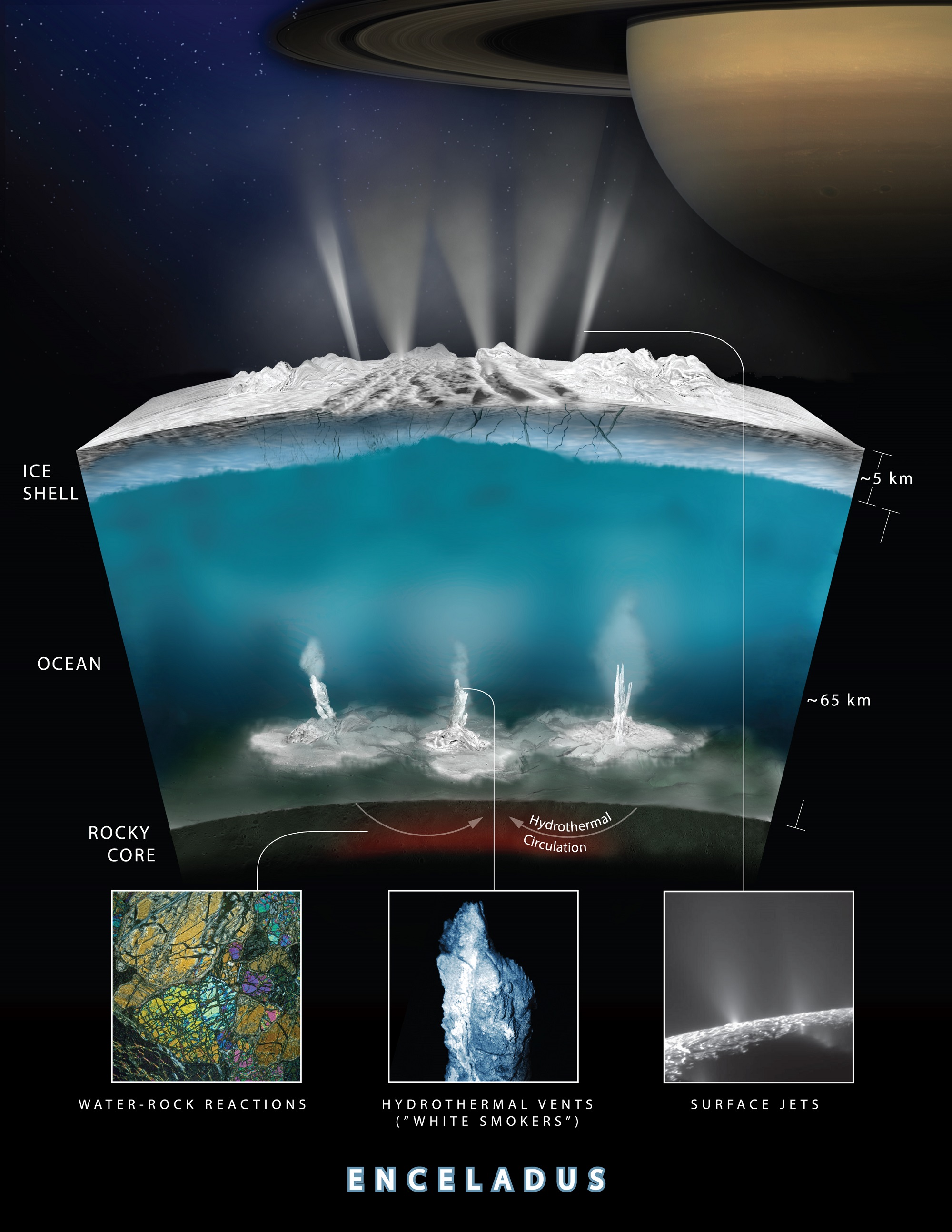
Cutaway showing the interior of Saturn’s moon Enceladus. Credit: ESA
To begin, Lingam and Loeb address the tendency to confuse habitable zones (HZs) with habitability, or to treat the two concepts as interchangeable. For instance, planets that are located within an HZ are not necessarily capable of supporting life – in this respect, Mars and Venus are perfect examples. Whereas Mars is too cold and it’s atmosphere too thin to support life, Venus suffered a runaway greenhouse effect that caused it to become a hot, hellish place.
On the other hand, bodies that are located beyond HZs have been found to be capable of having liquid water and the necessary ingredients to give rise to life. In this case, the moons of Europa, Ganymede, Enceladus, Dione, Titan, and several others serve as perfect examples. Thanks to the prevalence of water and geothermal heating caused by tidal forces, these moons all have interior oceans that could very well support life.
As Lingam, a post-doctoral researcher at the ITC and CfA and the lead author on the study, told Universe Today via email:
“The conventional notion of planetary habitability is the habitable zone (HZ), namely the concept that the “planet” must be situated at the right distance from the star such that it may be capable of having liquid water on its surface. However, this definition assumes that life is: (a) surface-based, (b) on a planet orbiting a star, and (c) based on liquid water (as the solvent) and carbon compounds. In contrast, our work relaxes assumptions (a) and (b), although we still retain (c).”
As such, Lingam and Loeb widen their consideration of habitability to include worlds that could have subsurface biospheres. Such environments go beyond icy moons such as Europa and Enceladus and could include many other types deep subterranean environments. On top of that, it has also been speculated that life could exist in Titan’s methane lakes (i.e. methanogenic organisms). However, Lingam and Loeb chose to focus on icy moons instead.
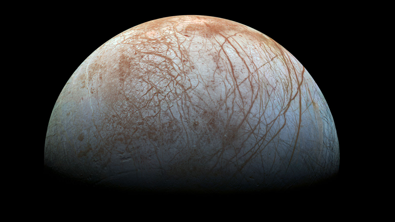
A “true color” image of the surface of Jupiter’s moon Europa as seen by the Galileo spacecraft. Image credit: NASA/JPL-Caltech/SETI Institute
“Even though we consider life in subsurface oceans under ice/rock envelopes, life could also exist in hydrated rocks (i.e. with water) beneath the surface; the latter is sometimes referred to as subterranean life,” said Lingam. “We did not delve into the second possibility since many of the conclusions (but not all of them) for subsurface oceans are also applicable to these worlds. Similarly, as noted above, we do not consider lifeforms based on exotic chemistries and solvents, since it is not easy to predict their properties.”
Ultimately, Lingam and Loeb chose to focus on worlds that would orbit stars and likely contain subsurface life humanity would be capable of recognizing. They then went about assessing the likelihood that such bodies are habitable, what advantages and challenges life will have to deal with in these environments, and the likelihood of such worlds existing beyond our Solar System (compared to potentially-habitable terrestrial planets).
For starters, “Ocean Worlds” have several advantages when it comes to supporting life. Within the Jovian system (Jupiter and its moons) radiation is a major problem, which is the result of charged particles becoming trapped in the gas giants powerful magnetic field. Between that and the moon’s tenuous atmospheres, life would have a very hard time surviving on the surface, but life dwelling beneath the ice would fare far better.
“One major advantage that icy worlds have is that the subsurface oceans are mostly sealed off from the surface,” said Lingam. “Hence, UV radiation and cosmic rays (energetic particles), which are typically detrimental to surface-based life in high doses, are unlikely to affect putative life in these subsurface oceans.”
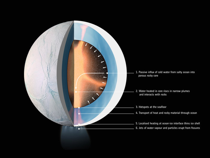
Artist rendering showing an interior cross-section of the crust of Enceladus, which shows how hydrothermal activity may be causing the plumes of water at the moon’s surface. Credits: NASA-GSFC/SVS, NASA/JPL-Caltech/Southwest Research Institute
“On the negative side,’ he continued, “the absence of sunlight as a plentiful energy source could lead to a biosphere that has far less organisms (per unit volume) than Earth. In addition, most organisms in these biospheres are likely to be microbial, and the probability of complex life evolving may be low compared to Earth. Another issue is the potential availability of nutrients (e.g. phosphorus) necessary for life; we suggest that these nutrients might be available only in lower concentrations than Earth on these worlds.”
In the end, Lingam and Loeb determined that a wide range of worlds with ice shells of moderate thickness may exist in a wide range of habitats throughout the cosmos. Based on how statistically likely such worlds are, they concluded that “Ocean Worlds” like Europa, Enceladus, and others like them are about 1000 times more common than rocky planets that exist within the HZs of stars.
These findings have some drastic implications for the search for extra-terrestrial and extra-solar life. It also has significant implications for how life may be distributed through the Universe. As Lingam summarized:
“We conclude that life on these worlds will undoubtedly face noteworthy challenges. However, on the other hand, there is no definitive factor that prevents life (especially microbial life) from evolving on these planets and moons. In terms of panspermia, we considered the possibility that a free-floating planet containing subsurface exolife could be temporarily “captured” by a star, and that it may perhaps seed other planets (orbiting that star) with life. As there are many variables involved, not all of them can be quantified accurately.”
A new instrument called the Search for Extra-Terrestrial Genomes (STEG) is being developed to find evidence of life on other worlds. Credit: NASA/Jenny Mottor
Professor Leob – the Frank B. Baird Jr. Professor of Science at Harvard University, the director of the ITC, and the study’s co-author – added that finding examples of this life presents its own share of challenges. As he told Universe Today via email:
“It is very difficult to detect sub-surface life remotely (from a large distance) using telescopes. One could search for excess heat but that can result from natural sources, such as volcanos. The most reliable way to find sub-surface life is to land on such a planet or moon and drill through the surface ice sheet. This is the approach contemplated for a future NASA mission to Europa in the solar system.”
Exploring the implications for panspermia further, Lingam and Loeb also considered what might happen if a planet like Earth were ever ejected from the Solar System. As they note in their study, previous research has indicated how planets with thick atmospheres or subsurface oceans could still support life while floating in interstellar space. As Loeb explained, they also considered what would happen if this ever happened with Earth someday:
“An interesting question is what would happen to the Earth if it was ejected from the solar system into cold space without being warmed by the Sun. We have found that the oceans would freeze down to a depth of 4.4 kilometers but pockets of liquid water would survive in the deepest regions of the Earth’s ocean, such as the Mariana Trench, and life could survive in these remaining sub-surface lakes. This implies that sub-surface life could be transferred between planetary systems.”
The Drake Equation, a mathematical formula for the probability of finding life or advanced civilizations in the universe. Credit: University of Rochester
This study also serves as a reminder that as humanity explores more of the Solar System (largely for the sake of finding extra-terrestrial life) what we find also has implications in the hunt for life in the rest of the Universe. This is one of the benefits of the “low-hanging fruit” approach. What we don’t know is informed but what we do, and what we find helps inform our expectations of what else we might find.
And of course, it’s a very vast Universe out there. What we may find is likely to go far beyond what we are currently capable of recognizing!
Google Maps now lets users explore the Solar System. Credit: NASA/Google
Chances are, at one time or another, we’ve all used Google Maps to find the shortest route from point A to point B. But if you are like some people, you’ve used this mapping tool to have a look at geographical features or places you hope to visit someday. In an age where digital technology is allowing for telecommuting and even telepresence, it’s nice to take virtual tours of the places we may never get to see in person.
But now, Google Maps is using its technology to enable the virtual exploration of something far grander: the Solar System! Thanks to images provided by the Cassini orbiter of the planets and moons it studied during its 20 year mission, Google is now allowing users to explore places like Venus, Mercury, Mars, Europa, Ganymede, Titan, and other far-off destinations that are impossible for us to visit right now.
Similar to how Google Earth uses satellite imagery to create 3D representations of our planet, this new Google Maps tool relies on the more than 500,000 images taken by Cassini as it made its way across the Solar System. This probe recently concluded its 20 year mission, 13 of which were spent orbiting Saturn and studying its system of moons, by crashing into the atmosphere of Saturn.
Artist rendition of the Cassini spacecraft over Saturn. Credit: NASA/JPL-Caltech/SSI/Kevin M. Gill.
After launching from Earth on October 15th, 1997, Cassini conducted a flyby of Venus in order to pick up a gravity-assist. It then flew by Earth, obtaining a second gravity-assist, while making its way towards the Asteroid Belt. Before reaching the Saturn System, where it would begin studying the gas giant and its moons, Cassini also conducted a flyby of Jupiter – snapping pictures of its moons, rings, and Great Red Spot.
When it reached Saturn in July of 2004, Cassini went to work studying the planet and its larger moons – particularly Titan and Enceladus. During the next 13 years and 76 days, the probe would provide breathtaking images and sensor data on Saturn’s rings, atmosphere and polar storms and reveal things about Titan’s surface that were never before seen (such as its methane lakes, hydrological cycle, and surface features).
It’s flybys of Enceladus also revealed some startling things about this icy moon. Aside from detecting a tenuous atmosphere of ionized water vapor and Enceladus’ mysterious “Tiger Stripes“, the probe also detected jets of water and organic molecules erupting from the moon’s southern polar region. These jets, it was later determined, were indicative of a warm water ocean deep in the moon’s interior, and possibly even life!
Interestingly enough, the original Cassini mission was only planned to last for four years once it reached Saturn – from June 2004 to May 2008. But by the end of this run, the mission was extended with the Cassini Equinox Mission, which was intended to run until September of 2010. It was extended a second time with the Cassini Solstice Mission, which lasted until September 15th, 2017, when the probe was crashed into Saturn’s atmosphere.
Artist’s impression of the Cassini orbiter entering Saturn’s atmosphere. Credit: NASA/JPL
Thanks to all the images taken by this long-lived mission, Google Maps is now able to offer exploratory tours of 16 celestial bodies in the Solar System – 12 of which are new to the site. These include Earth, the Moon, Mercury, Venus, Mars, Pluto, Ceres, Io, Europa, Ganymede, Mimas, Enceladus, Dione, Rhea, Titan, Iapetus and (available as of July 2017) the International Space Station.
This latest development also builds on several extensions Google has released over the years. These include Google Moon, which was released on July 20th, 2005, to coincide with the 36th anniversary of the Apollo 11 Moon Landing. Then there was Google Sky (introduced in 2007), which used photographs taken by the Hubble Space Telescope to create a virtual map of the visible universe.
Then there was Google Mars, the result of a collaborative effort between Google and NASA scientists at the Mars Space Flight Facility released in 2011, one year before the Curiosity rover landed on the Red Planet. This tool relied on data collected by the Mars Global Surveyor and the Mars Odyssey missions to create high-resolution 3D terrain maps that included elevations.
In an age of high-speed internet and telecommunications, using the internet to virtually explore the many planets and bodies of the Solar System just makes sense. Especially when you consider that even the most ambitious plans to conduct tourism to Mars or the Moon (looking at you, Elon Musk and Richard Branson!) are not likely to bear fruit for many years, and cost an arm and a leg to boot!
In the future, similar technology could lead to all kinds of virtual exploration. This concept, which is often referred to as “telexploration”, would involve robotic missions traveling to other planets and even star systems. The information they gather would then be sent back to Earth to create virtual experiences, which would allow scientists and space-exploration enthusiasts to feel like they were seeing it firsthand.
In truth, this mapping tool is just the latest gift to be bestowed by the late Cassini mission. NASA scientists expect to be sifting through the volumes of data collected by the orbiter for years to come. Thanks to improvements made in software applications and the realms of virtual and augmented reality, this data (and that of present and future missions) is likely to be put to good use, enabling breathtaking and educational tours of our Universe!
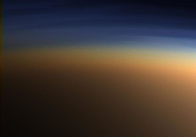
This view of Saturn’s largest moon, Titan, is among the last images the Cassini spacecraft sent to Earth before it plunged into the giant planet’s atmosphere. Credits: NASA/JPL-Caltech/Space Science Institute
During the 13 years and 76 days that the Cassini mission spent around Saturn, the orbiter and its lander (the Huygens probe) revealed a great deal about Saturn and its systems of moons. This is especially true of Titan, Saturn’s largest moon and one of the most mysterious objects in the Solar System. As a result of Cassini’s many flybys, scientists learned a great deal about Titan’s methane lakes, nitrogen-rich atmosphere, and surface features.
Even though Cassini plunged into Saturn’s atmosphere on September 15th, 2017, scientists are still pouring over the things it revealed. For instance, before it ended its mission, Cassini captured an image of a strange cloud floating high above Titan’s south pole, one which is composed of toxic, hybrid ice particles. This discovery is another indication of the complex organic chemistry occurring in Titan’s atmosphere and on it’s surface.
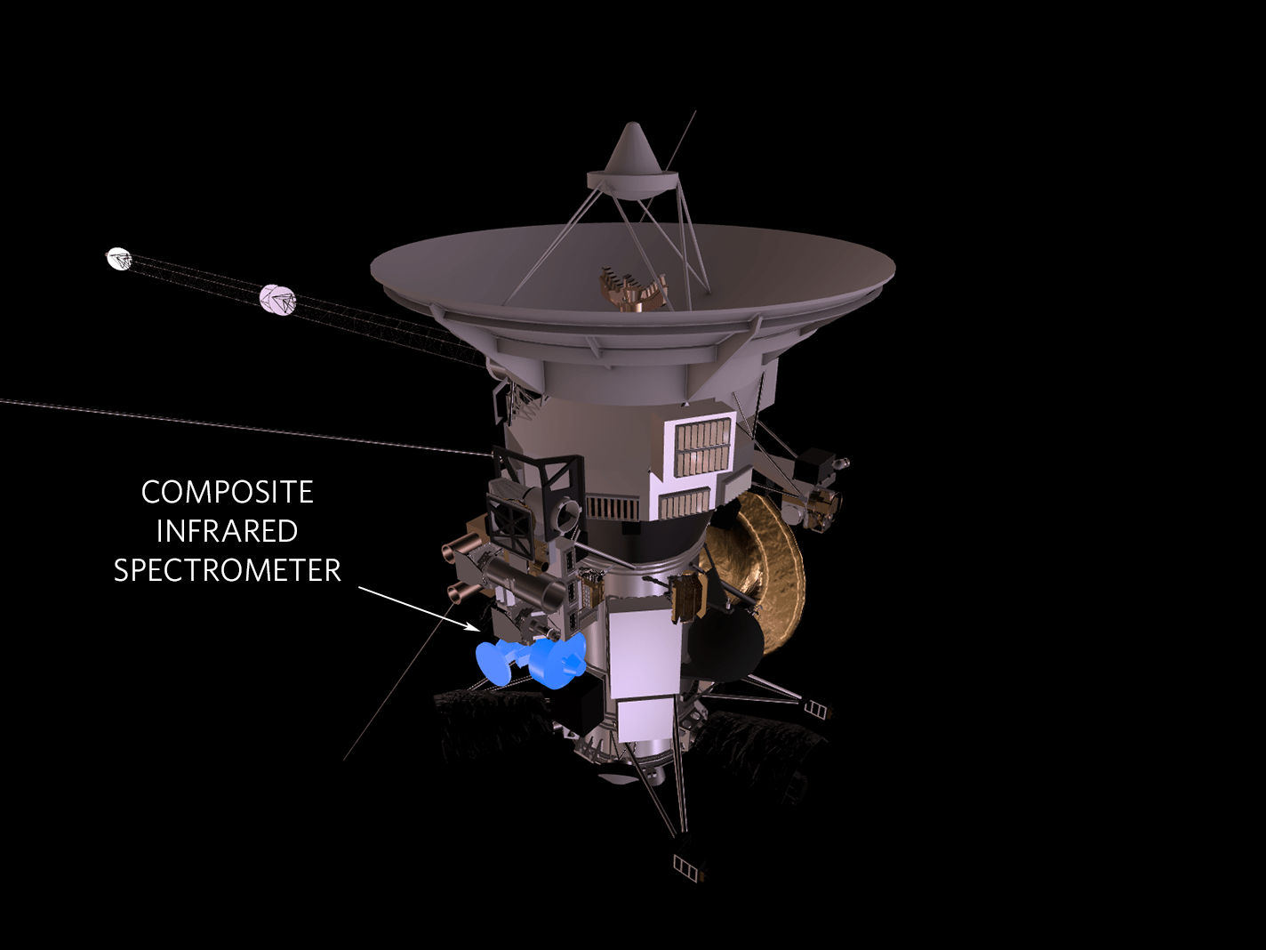
Since this cloud was invisible to the naked eye, it was only observable thanks to Cassini’s Composite Infrared Spectrometer (CIRS). This instrument spotted the cloud at an altitude of about 160 to 210 km (100 to 130 mi), far above the methane rain clouds of Titan’s troposphere. It also covered a large area near the south pole, between 75° and 85° south latitude.
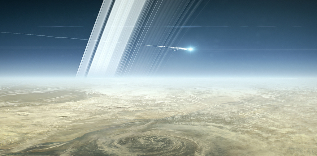
Artist concept of Cassini’s last moments at Saturn. Credit: NASA/JPL.
Using the chemical fingerprint obtained by the CIRS instrument, NASA researchers also conducted laboratory experiments to reconstruct the chemical composition of the cloud. These experiments determined that the cloud was composed of the organic molecules hydrogen cyanide and benzene. These two chemicals appeared to have condensed together to form ice particles, rather than being layered on top of each other.
For those who have spent more than the past decade studying Titan’s atmosphere, this was a rather interesting and unexpected find. As Carrie Anderson, a CIRS co-investigator at NASA’s Goddard Space Flight Center, said in a recent NASA press statement:
“This cloud represents a new chemical formula of ice in Titan’s atmosphere. What’s interesting is that this noxious ice is made of two molecules that condensed together out of a rich mixture of gases at the south pole.”
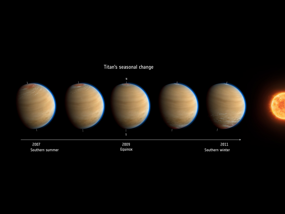
The presence of this cloud around Titan’s southern pole is also another example of the moon’s global circulation patterns. This involves currents of warm gases being sent from the hemisphere that is experiencing summer to the hemisphere experience winter. This pattern reverse direction when the seasons change, which leads to a buildup of clouds around whichever pole is experiencing winter.
Artist’s impression of Saturn’s moon Titan shows the change in observed atmospheric effects before, during and after equinox in 2009. Credit: NASA
When the Cassini orbiter arrived at Saturn in 20o4, Titan’s northern hemisphere was experiencing winter – which began in 2004. This was evidenced by the buildup of clouds around its north pole, which Cassini spotted during its first encounter with the moon later than same year. Similarly, the same phenomena was taking place around the south pole near the end of Cassini’s mission.
This was consistent with seasonal changes on Titan, which take place roughly every seven Earth years – a year on Titan lasts about 29.5 Earth years. Typically, the clouds that form in Titan’s atmosphere are structured in layers, where different types of gas will condense into icy clouds at different altitudes. Which ones condense is dependent on how much vapor is present and temperatures – which become steadily colder closer to the surface.
However, at times, different types of clouds can form over a range of altitudes, or co-condense with other types of clouds. This certainly appeared to be the case when it came to the large cloud of hydrogen cyanide and benzene that was spotted above the south pole. Evidence of this cloud was derived from three sets of Titan observations made with the CIRS instrument, which took place between July and November of 2015.
The CIRS instrument works by separating infrared light into its constituent colors, and then measures the strengths of these signals at the different wavelengths to determine the presence of chemical signatures. Previously, it was used to identify the presence of hydrogen cyanide ice clouds over the south pole, as well as other toxic chemicals in the moon’s stratosphere.
Artist’s impression of the Cassini orbiter’s Composite Infrared Spectrometer (CIRS). Credit: NASA-JPL
As F. Michael Flasar, the CIRS principal investigator at Goddard, said:
“CIRS acts as a remote-sensing thermometer and as a chemical probe, picking out the heat radiation emitted by individual gases in an atmosphere. And the instrument does it all remotely, while passing by a planet or moon.”
However, when examining the observation data for chemical “fingerprints”, Anderson and her colleagues noticed that the spectral signatures of the icy cloud did not match those of any individual chemical. To address this, the team began conducting laboratory experiments where mixtures of gases were condensed in a chamber that simulated conditions in Titan’s stratosphere.
After testing different pairs of chemicals, they finally found one which matched the infrared signature observed by CIRS. At first, they tried letting one gas condense before the other, but found that the best results were obtained when both gases were introduced and allowed to condense at the same time. To be fair, this was not the first time that Anderson and her colleagues had discovered co-condensed ice in CIRS data.
For example, similar observations were made near the north pole in 2005, about two years after the northern hemisphere experienced its winter solstice. At that time, the icy clouds were detected at a much lower altitude (below 150 km, or 93 mi) and showed chemical fingerprints of hydrogen cyanicide and caynoacetylene – one of the more complex organic molecules in Titan’s atmosphere.
Artist’s impression of the Cassini orbiter entering Saturn’s atmosphere. Credit: NASA/JPL
This difference between this and the latest detection of a hybrid cloud, according to Anderson, comes down to differences in seasonal variations between the north and south poles. Whereas the northern polar cloud observed in 2005 was spotted about two years after the northern winter solstice, the southern cloud Anderson and her team recently examined was spotted two years before the southern winter solstice.
In short, it is possible that the mixture of the gases was slightly different in the two case, and/or that the northern cloud had a chance to warm slightly, thus altering its composition somewhat. As Anderson explained, these observations were made possible thanks to the many years that the Cassini mission spent around Saturn:
“One of the advantages of Cassini was that we were able to flyby Titan again and again over the course of the thirteen-year mission to see changes over time. This is a big part of the value of a long-term mission.”
Additional studies will certainly be needed to determine the structure of these icy clouds of mixed composition, and Anderson and her team already have some ideas on how they would look. For their money, the researchers expect these clouds to be lumpy and disorderly, rather than well-defined crystals like the single-chemical clouds.
In the coming years, NASA scientists are sure to be spending a great deal of time and energy sorting through all the data obtained by the Cassini mission over the course of its 13-year mission. Who knows what else they will detect before they have exhausted the orbiter’s vast collections of data?
If you would like to join the Weekly Space Hangout Crew, visit their site here and sign up. They’re a great team who can help you join our online discussions!
We record the Weekly Space Hangout every Wednesday at 5:00 pm Pacific / 8:00 pm Eastern. You can watch us live on Universe Today, or the Weekly Space Hangout YouTube page – Please subscribe!
According to a study from UCLA, Titan experiences severe methane rainstorms, leading to a the alluvial fans found found in both hemispheres. Credit:
NASA/JPL-Caltech/Space Science Institute
Saturn’s largest moon, Titan, is a mysterious place; and the more we learn about it, the more surprises it seems to have in store. Aside from being the only body beyond Earth that has a dense, nitrogen-rich atmosphere, it also has methane lakes on its surface and methane clouds in its atmosphere. This hydrological-cycle, where methane is converted from a liquid to a gas and back again, is very similar to the water cycle here on Earth.
Thanks to the NASA/ESA Cassini-Huygens mission, which concluded on September 15th when the craft crashed into Saturn’s atmosphere, we have learned a great deal about this moon in recent years. The latest find, which was made by a team of UCLA planetary scientists and geologists, has to do with Titan’s methane rain storms. Despite being a rare occurrence, these rainstorms can apparently become rather extreme.
Image of Titan’s atmosphere, snapped by the Cassini spacecraft. Credit: NASA/JPL/Space Science Institute
What they found was that the extreme methane rainstorms may imprint the moon’s icy surface in much the same way that extreme rainstorms shape Earth’s rocky surface. On Earth, intense rainstorms play an important role in geological evolution. When rainfall is heavy enough, storms can trigger large flows of water that transport sediment into low lands, where it forms cone-shaped features known as alluvial fans.
During it’s mission, the Cassini orbiter found evidence of similar features on Titan using its radar instrument, which suggested that Titan’s surface could be affected by intense rainfall. While these fans are a new discovery, scientists have been studying the surface of Titan ever since Cassini first reached the Saturn system in 2006. In that time, they have noted several interesting features.
These included the vast sand dunes that dominate Titan’s lower latitudes and the methane lakes and seas that dominate it’s higher latitudes – particularly around the northern polar region. The seas – Kraken Mare, Ligeia Mare, and Punga Mare – measure hundreds of km across and up to several hundred meters deep, and are fed by branching, river-like channels. There are also many smaller, shallower lakes that have rounded edges and steep walls, and are generally found in flat areas.
In this case, the UCLA scientists found that the alluvial fans are predominantly located between 50 and 80 degrees latitude. This puts them close to the center of the northern and southern hemispheres, though slightly closer to the poles than the equator. To test how Titan’s own rainstorms could cause these features, the UCLA team relied on computer simulations of Titan’s hydrological cycle.
False-color mosaic of Titan’s northern lakes, made from infrared data collected by NASA’s Cassini spacecraft. Credit: NASA
What they found was that while rain mostly accumulates near the poles – where Titan’s major lakes and seas are located – the most intense rainstorms occur near 60 degrees latitude. This corresponds to the region where alluvial fans are most heavily concentrated, and indicates that when Titan does experience rainfall, it is quite extreme – like a seasonal monsoon-like downpour.
As Jonathan Mitchell – a UCLA associate professor of planetary science and a senior author of the study – indicated, this is not dissimilar to some extreme weather events that were recently experienced here on Earth. “The most intense methane storms in our climate model dump at least a foot of rain a day, which comes close to what we saw in Houston from Hurricane Harvey this summer,” he said.
The team also found that on Titan, methane rainstorms are rather rare, occurring less than once per Titan year – which works out to 29 and a half Earth years. But according to Mitchell, who is also the principal investigator of UCLA’s Titan climate modeling research group, this is more often than they were expecting. “I would have thought these would be once-a-millennium events, if even that,” he said. “So this is quite a surprise.”
In the past, climate models of Titan have suggested that liquid methane generally concentrates closer to the poles. But no previous study has investigated how precipitation might cause sediment transport and erosion, or shown how this would account for various features observed on the surface. As a result, this study also suggests that regional variations in surface features could be caused by regional variations in precipitation.
On top of that, this study is an indication that Earth and Titan have even more in common than previously thought. On Earth, contrasts in temperature are what lead to intense seasonal weather events. In North America, tornadoes occur during the early to late Spring, while blizzards occur during the winter. Meanwhile, temperature variations in the Atlantic ocean are what lead to hurricanes forming between the summer and fall.
Similarly, it appears that on Titan, serious variations in temperature and moisture are what triggers extreme weather. When cooler, wetter air from the higher latitudes interacts with warmer, drier air from the lower latitudes, intense rainstorms result. These findings are also significant when it comes to other bodies in our Solar System that have alluvial fans on them – such as Mars.
In the end, understanding the relationship between precipitation and planetary surfaces could lead to new insights about the impact climate change has on Earth and the other planets. Such knowledge would also go a long way towards helping us mitigate the effects it is having here on Earth, where the changes are only unnatural, but also sudden and very hazardous.
And who knows? Someday, it could even help us to alter the environments on other planets and bodies, thus making them more suitable for long-term human settlement (aka. terraforming)!
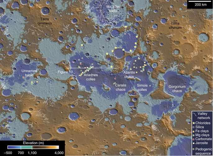
MOLA topographic data, colorized to show the maximum (1,100?m) and minimum (700?m) level of an ancient sea. Credit: NASA/Joseph R. Michalski (et al.)/Nature Communications
It is now a well-understood fact that Mars once had quite a bit of liquid water on its surface. In fact, according to a recent estimate, a large sea in Mars’ southern hemisphere once held almost 10 times as much water as all of North America’s Great Lakes combined. This sea existed roughly 3.7 billion years ago, and was located in the region known today as the Eridania basin.
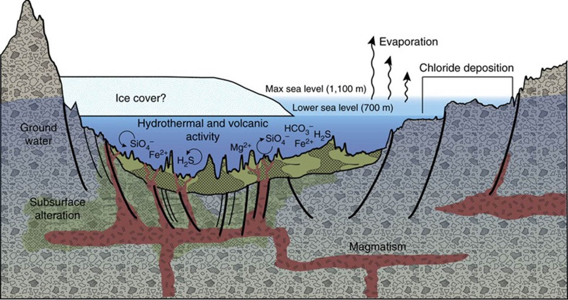
However, a new study based on data from NASA’s Mars Reconnaissance Orbiter (MRO) detected vast mineral deposits at the bottom of this basin, which could be seen as evidence of ancient hot springs. Since this type of hydrothermal activity is believed to be responsible for the emergence of life on Earth, these results could indicate that this basin once hosted life as well.
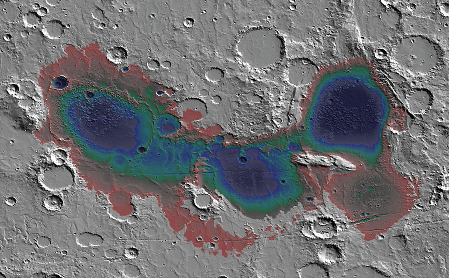
The Eridania basin of southern Mars is believed to have held a sea about 3.7 billion years ago, with seafloor deposits likely resulting from underwater hydrothermal activity. Credit: NASA
Together, this international team used data obtained by the MRO’s Compact Reconnaissance Spectrometer for Mars (CRISM). Since the MRO reached Mars in 2006, this instrument has been used extensively to search for evidence of mineral residues that form in the presence of water. In this respect, CRISM was essential for documenting how lakes, ponds and rivers once existed on the surface of Mars.
In this case, it identified massive mineral deposits within Mars’ Eridania basin, which lies in a region that has some of the Red Planet’s most ancient exposed crust. The discovery is expected to be a major focal point for scientists seeking to characterize Mars’ once-warm and wet environment. As Paul Niles of NASA’s Johnson Space Center said in a recent NASA press statement:
“Even if we never find evidence that there’s been life on Mars, this site can tell us about the type of environment where life may have begun on Earth. Volcanic activity combined with standing water provided conditions that were likely similar to conditions that existed on Earth at about the same time — when early life was evolving here.”
Today, Mars is a cold, dry place that experiences no volcanic activity. But roughly 3.7 billion years ago, the situation was vastly different. At that time, Mars boasted both flowing and standing bodies of water, which are evidenced by vast fluvial deposits and sedimentary basins. The Gale Crater is a perfect example of this since it was once a major lake bed, which is why it was selected as the landing sight for the Curiosity rover in 2012.
Illustrates showing the origin of some deposits in the Eridania basin of southern Mars resulting from seafloor hydrothermal activity more than 3 billion years ago. Credit: NASA
Since Mars had both surface water and volcanic activity during this time, it would have also experienced hydrothermal activity. This occurs when volcanic vents open into standing bodies of water, filling them with hydrated minerals and heat. On Earth, which still has an active crust, evidence of past hydrothermal activity cannot be preserved. But on Mars, where the crust is solid and erosion is minimal, the evidence has been preserved.
“This site gives us a compelling story for a deep, long-lived sea and a deep-sea hydrothermal environment,” Niles said. “It is evocative of the deep-sea hydrothermal environments on Earth, similar to environments where life might be found on other worlds — life that doesn’t need a nice atmosphere or temperate surface, but just rocks, heat and water.”
Based on their study, the researchers estimate that the Eridania basin once held about 210,000 cubic km (50,000 cubic mi) of water. Not only is this nine times more water than all of the Great Lakes combined, it is as much as all the other lakes and seas on ancient Mars combined. In addition, the region also experienced lava flows that existed after the sea is believed to have disappeared.
From the CRISM’s spectrometer data, the team identified deposits of serpentine, talc and carbonate. Combined with the shape and texture of the bedrock layers, they concluded that the sea floor was open to volcanic fissures. Beyond indicating that this region could have once hosted life, this study also adds to the diversity of the wet environments which are once believed to have existed on Mars.
A scale model compares the volume of water contained in lakes and seas on the Earth and Mars to the estimated volume of water contained in an ancient Eridania sea. Credit: JJoseph R. Michalski (et al.)/Nature Communications
Between evidence of ancient lakes, rivers, groundwater, deltas, seas, and volcanic eruptions beneath ice, scientists now have evidence of volcanic activity that occurred beneath a standing body of water (aka. hot springs) on Mars. This also represents a new category for astrobiological research, and a possible destination for future missions to the Martian surface.
The study of hydrothermal activity is also significant as far as finding sources of extra-terrestrial, like on the moons of Europa, Enceladus, Titan, and elsewhere. In the future, robotic missions are expected to travel to these worlds in order to peak beneath their icy surfaces, investigate their plumes, or venture into their seas (in Titan’s case) to look for the telltale traces of basic life forms.
The study also has significance beyond Mars and could aid in the study of how life began here on Earth. At present, the earliest evidence of terrestrial life comes from seafloor deposits that are similar in origin and age to those found in the Eridania basin. But since the geological record of this period on Earth is poorly preserved, it has been impossible to determine exactly what conditions were like at this time.
Given Mars’ similarities with Earth, and the fact that its geological record has been well-preserved over the past 3 billion years, scientists can look to mineral deposits and other evidence to gauge how natural processes here on Earth allowed for life to form and evolve over time. It could also advance our understanding of how all the terrestrial planets of the Solar System evolved over billions of years.