Saturn Shows Off Its Shadow

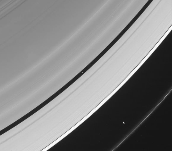
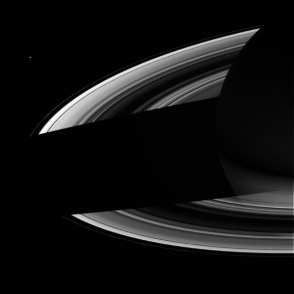
Take a look up at the enormous shadow cast by Saturn onto its own rings in this raw image, acquired by NASA’s Cassini spacecraft on September 18, 2012.

Cassini captured this image from below Saturn’s ring plane at a distance of 1,393,386 miles (2,242,437 kilometers). It shows not only the gas giant’s shadow but also the wispy nature of the rings, which, although complex, extensive and highly reflective (the light seen on Saturn above is reflected light from the rings!) they are still very thin — less than a mile (about 1 km) on average and in some places as little as thirty feet (10 meters) thick.

Seen in the right light, some of the thin innermost rings can seem to nearly disappear entirely — especially when backlit by Saturn itself.

Views like the one above are once again possible because of Cassini’s new orbit, which takes it high above and below the ring plane, providing a new perspective for studying Saturn and its moons. Ultimately by next April the spacecraft will be orbiting Saturn at an inclination of about 62 degrees — that’d be like an orbit around Earth that goes from Alaska to the northernmost tip of Antarctica. (Find out how Cassini alters its orbit here.)

With this viewpoint Cassini will get some great views of Saturn’s north and south poles, which are gradually moving into their summer and winter seasons, respectively, during the ringed planet’s 29.5-Earth-year orbital period.

After more than 8 years in orbit Cassini is still fascinating us with enthralling images of Saturn on a regular basis. Read more about the Cassini mission here.

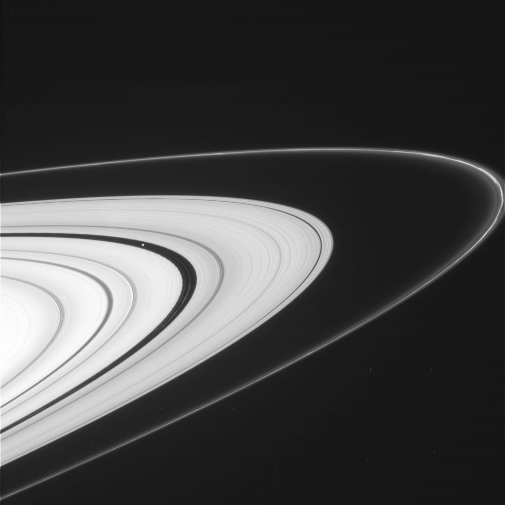
Cassini spots shepherd moons Pan (within the Encke Gap) and Prometheus (along the inner edge of the F ring) in an image acquired on Sept. 18, 2012

Images: NASA/JPL/Space Science Institute.

Clay Deposits Don’t Prove Existence of Ancient Martian Lakes

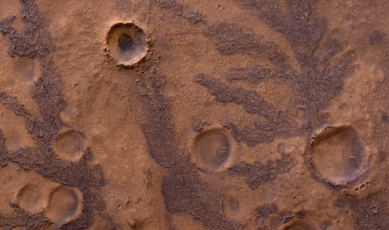
HiRISE image of branching features in the floor of Antoniadi Crater thought to contain clay material. (NASA/JPL/University of Arizona)

In the hunt for evidence of a warmer, wetter past on Mars, clay deposits have been viewed as good indications that stable liquid water existed on its surface for some time — perhaps even long enough to allow life to develop. But new research conducted here on Earth shows that some clays don’t necessarily need lakes of liquid water to form. Instead they can be the result of volcanic activity, which is not nearly so hospitable to life.

A research team led by Alain Meunier of the Université de Poitiers in France studied lavas containing iron and magnesium — similar to ancient clays identified on the surface of Mars — in the French Polynesian atoll of Moruroa. The team’s findings show that the same types of clay outcrops can be caused by the solidifying of water-rich magma in a volcanic environment, and don’t require Earthlike aquatic conditions at all.

The results also correlate to the deuterium-to-hydrogen (D/H) ratio within clays found in Martian meteorites.

Read: Life from Mars Could Have Polluted Earth

“To crystallize, clays need water but not necessarily liquid water,” said Alain Meunier to the Agençe France-Presse (AFP). “Consequently, they cannot be used to prove that the planet was habitable or not during its early history.”

Additionally, the clay deposits found on Mars can be several hundred meters thick, which seems to be more indicative of upwelling magma than interactions with water.

“[This] new hypothesis proposes that the minerals instead formed during brief periods of magmatic degassing, diminishing the prospects for signs of life in these settings,” wrote Brian Hynek from the Department of Geological Sciences at the University of Colorado, in response to the paper by Meunier et al. which was published in the September 9 edition of the journal Nature Geoscience.

This does not necessarily mean that all Martian clays weren’t formed in the presence of water, however. Gale Crater — where NASA’s Curiosity rover is now exploring — could very well have been the site of a Martian lake, billions of years in the past. Clays found there could have been created by water.

Read: Take a Trip to Explore Gale Crater

According to Bethany Ehlmann of the California Institute of Technology, co-author of the study, “there are particular characteristics of texture” to clays formed under different conditions, and “Gale is a different flavor of Mars.”

Perhaps Curiosity will yet discover if Gale’s original flavor was more cool and wet than hot and spicy.

Read more on New Scientist and Cosmos Magazine.

Inset image: Moruroa Atoll (NASA) 

Is Triton Hiding an Underground Ocean?

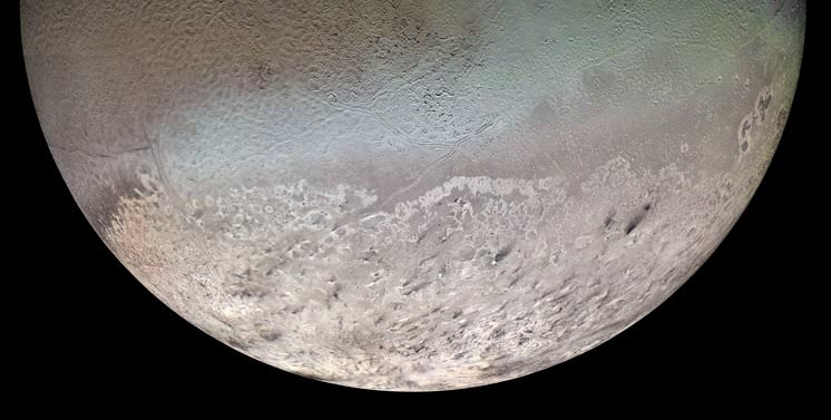
Voyager 2 mosaic of Neptune’s largest moon, Triton (NASA)

At 1,680 miles (2,700 km) across, the frigid and wrinkled Triton is Neptune’s largest moon and the seventh largest in the Solar System. It orbits the planet backwards – that is, in the opposite direction that Neptune rotates – and is the only large moon to do so, leading astronomers to believe that Triton is actually a captured Kuiper Belt Object that fell into orbit around Neptune at some point in our solar system’s nearly 4.7-billion-year history.

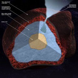
Briefly visited by Voyager 2 in late August 1989, Triton was found to have a curiously mottled and rather reflective surface nearly half-covered with a bumpy “cantaloupe terrain” and a crust made up of mostly water ice, wrapped around a dense core of metallic rock. But researchers from the University of Maryland are suggesting that between the ice and rock may lie a hidden ocean of water, kept liquid despite estimated temperatures of  -97°C (-143°F), making Triton yet another moon that could have a subsurface sea.

How could such a chilly world maintain an ocean of liquid water for any length of time? For one thing, the presence of ammonia inside Triton would help to significantly lower the freezing point of water, making for a very cold — not to mention nasty-tasting — subsurface ocean that refrains from freezing solid.

In addition to this, Triton may have a source of internal heat — if not several. When Triton was first captured by Neptune’s gravity its orbit would have initially been highly elliptical, subjecting the new moon to intense tidal flexing that would have generated quite a bit of heat due to friction (not unlike what happens on Jupiter’s volcanic moon Io.) Although over time Triton’s orbit has become very nearly circular around Neptune due to the energy loss caused by such tidal forces, the heat could have been enough to melt a considerable amount of water ice trapped beneath Triton’s crust.

Related: Titan’s Tides Suggest a Subsurface Sea

Another possible source of heat is the decay of radioactive isotopes, an ongoing process which can heat a planet internally for billions of years. Although not alone enough to defrost an entire ocean, combine this radiogenic heating with tidal heating and Triton could very well have enough warmth to harbor a thin, ammonia-rich ocean beneath an insulating “blanket” of frozen crust for a very long time — although eventually it too will cool and freeze solid like the rest of the moon. Whether this has already happened or still has yet to happen remains to be seen, as several unknowns are still part of the equation.

“I think it is extremely likely that a subsurface ammonia-rich ocean exists in Triton,” said Saswata Hier-Majumder at the University of Maryland’s Department of Geology, whose team’s paper was recently published in the August edition of the journal Icarus. “[Yet] there are a number of uncertainties in our knowledge of Triton’s interior and past which makes it difficult to predict with absolute certainty.”

Still, any promise of liquid water existing elsewhere in large amounts should make us take notice, as it’s within such environments that scientists believe lie our best chances of locating any extraterrestrial life. Even in the farthest reaches of the Solar System, from the planets to their moons, into the Kuiper Belt and even beyond, if there’s heat, liquid water and the right elements — all of which seem to be popping up in the most surprising of places — the stage can be set for life to take hold.

Read more about this here on Astrobiology.net.

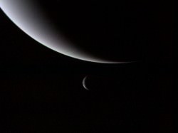
Inset image: Voyager 2 portrait of Neptune and Triton taken on August 28, 1989. (NASA)

What Has the Kuiper Belt Taught Us About The Solar System?

Over 4 billion miles (6.7 billion km) from the Sun, the Kuiper Belt is a vast zone of frozen worlds we still know very little about. Image: Johns Hopkins University Applied Physics Laboratory/Southwest Research Institute (JHUAPL/SwRI)

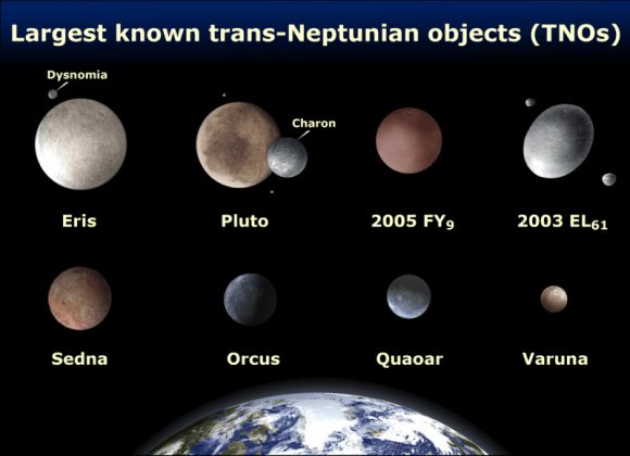
Today marks the 20th anniversary of the discovery of the first Kuiper Belt Object, 1992QB1. KBOs are distant and mostly tiny worlds made up of ice and rock that orbit the Sun at incredible distances, yet are still very much members of our Solar System. Since 1992 over 1,300 KBOs have been found, and with NASA’s New Horizons spacecraft speeding along to its July 2015 rendezvous with Pluto and Charon (which one could argue are technically the first KBOs ever found) and then onwards into the Belt, we will soon know much more about these far-flung denizens of deep space.

But how has the discovery of the Kuiper Belt — first proposed by Gerard Kuiper in 1951 (and in a fashion even earlier by Kenneth Edgeworth) — impacted our current understanding of the Solar System? New Horizons Principal Investigator Alan Stern from the Southwest Research Institute recently discussed this on his mission blog, “The PI’s Perspective.”

First, Stern lists some of the surprisingly diverse physical aspects of KBOs that have been discovered so far:

  • Some are red and some are gray;
  • The surfaces of some are covered in water ice, but others (like Pluto) have exotic volatile ices like methane and nitrogen;
  • Many have moons, though none with more known moons than Pluto;
  • Some are highly reflective (like Pluto), others have much darker surfaces;
  • Some have much lower densities than Pluto, meaning they are primarily made of ice. Pluto’s density is so high that we know its interior is about 70% rock in its interior; a few known KBOs are more dense than Pluto, and even rockier!

But although these features are fascinating in themselves, just begging for further exploration, Stern notes that there are three very important lessons that the Kuiper Belt has taught us about the Solar System:

1. Our planetary system is much larger than we had ever thought.

“In fact, we were largely unaware of the Kuiper Belt — the largest structure in our solar system — until it was discovered 20 years ago,”  Stern writes. “It’s akin to not having maps of the Earth that included the Pacific Ocean as recently as 1992!”

2. Planetary locations and orbits can change over time.

“This even creates whole flocks of migration of planets in some cases. We have firm evidence that many KBOs (including some large ones like Pluto), were born much closer to the Sun, in the region where the giant planets now orbit.”

3. Our solar system, and likely others as well, was very good at making small planets.

“Today we know of more than a dozen dwarf planets in the solar system, and those dwarfs already outnumber the number of gas giants and terrestrial planets combined. But it is estimated that the ultimate number of dwarf planets we will discover in the Kuiper Belt and beyond may well exceed 10,000. Who knew?”

And with a little jab at the whole Pluto-isn’t-a-planet topic, Stern asks: “And which class of planet is the misfit now?”

Read: Was Pluto Ever REALLY a Planet?

The discovery of the Kuiper Belt has shown us that our solar system — and very likely planetary systems across the galaxy, even the Universe — aren’t neat and tidy things that can be easily summed up with grade-school models or chalkboard diagrams. Instead they are incredibly diverse and dynamic, continually evolving and consisting of countless, varied worlds spanning enormous distances… yet still connected through the ever-present effects of gravity (not to mention the occasional-yet-unavoidable collision.)

“What an amazing set of paradigm shifts in our knowledge the Kuiper Belt has brought so far. Our quaint 1990s and earlier view of the solar system missed its largest structure!”

– Alan Stern, New Horizons Principal Investigator

Read more about the New Horizons mission here.

 The first KBO identified, 1992 QB1 (European Southern Observatory)

Winds of Change at the Edge of the Solar System

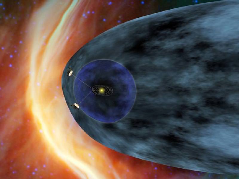
As the venerable Voyager 1 spacecraft hurtles ever outward, breaking through the very borders of our solar system at staggering speeds upwards of 35,000 mph, it’s sending back information about the curious region of space where the Sun’s outward flow of energetic particles meets the more intense cosmic radiation beyond — a boundary called the heliosheath.

Voyager 1 has been traveling through this region for the past seven years, all the while its instruments registering gradually increasing levels of cosmic ray particles. But recently the levels have been jumping up and down, indicating something new is going on… perhaps Voyager 1 is finally busting through the breakers of our Sun’s cosmic bay into the open ocean of interstellar space?

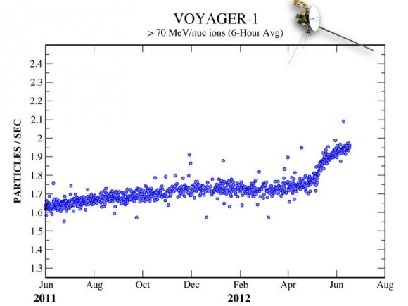
Data sent from Voyager 1 — a trip that currently takes the information nearly 17 hours to make — have shown steadily increasing levels of cosmic radiation as the spacecraft moves farther from the Sun. But on July 28, the levels of high-energy cosmic particles detected by Voyager jumped by 5 percent, with levels of lower-energy radiation from the Sun dropping by nearly half later the same day. Within three days both levels had returned to their previous states.

The last time such a jump in levels occurred was in May — and that spike took a week to happen.

“The increase and the decrease are sharper than we’ve seen before, but that’s also what we said about the May data,” said Edward Stone, the Voyager project scientist based at the California Institute of Technology. “The data are changing in ways that we didn’t expect, but Voyager has always surprised us with new discoveries.”

The graph below shows the jump in cosmic particles detected starting May 2012.

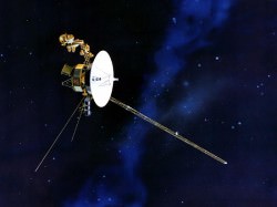
Over 11 billion miles (18 billion km) from home, Voyager 1 has been cruising through space since its launch on September 5, 1977. Its twin, Voyager 2, was launched two weeks earlier and is currently 9.3 billion miles (15 billion km) away. Both spacecraft are healthy and continue to communicate with Earth, and will both eventually break through the borders of our solar system and enter true interstellar space. If they are still operational when that happens — and there’s no reason that they shouldn’t be — we will finally get a sense of what conditions are like “out there”.

Although Voyager 1 is registering intriguing fluctuations in radiation from both inside and outside the Solar System, it’s not quite there yet.

“Our two veteran Voyager spacecraft are hale and healthy as they near the 35th anniversary of their launch,” said Suzanne Dodd, Voyager project manager based at JPL in Pasadena. “We know they will cross into interstellar space. It’s just a question of when.”

Read more about Voyager’s ongoing breakout here.

“We are certainly in a new region at the edge of the solar system where things are changing rapidly. But we are not yet able to say that Voyager 1 has entered interstellar space.”

–  Edward Stone, Voyager project scientist, Caltech

Images: NASA/JPL-Caltech

Beneath the Mask, Titan looks Surprisingly Smooth and Youthful

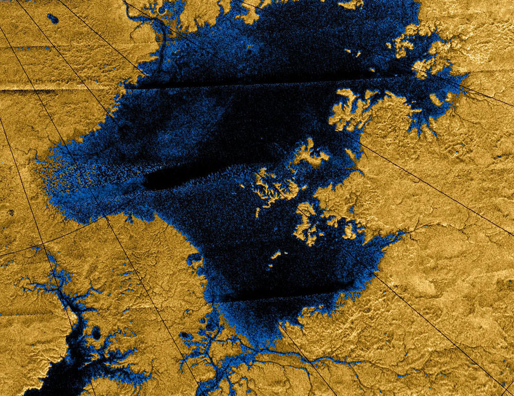
Images from the Cassini mission show river networks draining into lakes in Titans north polar region. Credit: NASA/JPL/USGS.

Caption: Images from the Cassini mission show methane river networks draining into lakes in Titan’s north polar region. Credit: NASA/JPL/USG

Saturn’s largest moon, Titan has long been hidden beneath the thick shroud of its methane- and nitrogen-rich atmosphere. That all changed in 2004 when NASA’s Cassini mission was able to penetrate the haze and sent back detailed radar images of the surface. These showed an icy terrain, carved over millions of years, by rivers similar to those found here on Earth. However, Titan’s surface doesn’t look as old and weather-beaten as it should. The rivers have caused surprisingly little erosion and there are fewer impact craters than would be expected. So what is the secret to Titan’s youthful complexion?

Titan is around four billion years old, roughly the same age as the rest of the solar system. But the low number of impact craters put estimates of its surface at only between 100 million and one billion years old.

Researchers at MIT and the University of Tennessee at Knoxville have analyzed images of Titan’s river networks and suggest two possible explanations: either erosion on Titan is extremely slow, or some recent phenomena has wiped out older surface features.

Taylor Perron, the Cecil and Ida Green Assistant Professor of Geology at MIT explains, “It’s a surface that should have eroded much more than what we’re seeing, if the river networks have been active for a long time. It raises some very interesting questions about what has been happening on Titan in the last billion years.”

Perron suggests that geological processes on Titan may be like those we see here on Earth. Here too, impact craters are scarce, as plate tectonics, erupting volcanoes, advancing glaciers and river networks reshaped our planet’s surface over billions of years, so, on Titan, tectonic upheaval, cryovolcanic eruptions, erosion and sedimentation by rivers could be altering the surface.

Discovering which processes are at work is not easy. The images from Cassini are like aerial photos but with much coarser resolution. They are flat, with no information about a surface elevation or depth.

Perron and MIT graduate student Benjamin Black analyzed the images and mapped 52 prominent river networks from four regions on Titan. They then compared the images with a model of river network evolution developed by Perron. Their data depicts the evolution of a river over time, taking into account variables such as the strength of the underlying material and the rate of flow through the river channels. As a river erodes, it transforms from a long, spindly thread into a dense, treelike network of tributaries. Titan’s river networks have maintained their long and spindly composition. They compare with recently renewed landscapes here including volcanic terrain on the island of Kauai and recently glaciated landscapes in North America.

Besides Earth, Titan is the only world with an active hydrologic cycle forming active river networks. Titan’s surface temperature may be about 94 K and its rivers run with liquid methane but as Perron says “It’s a weirdly Earth-like place, even with this exotic combination of materials and temperatures, and so you can still say something definitive about the erosion. It’s the same physics.”

Below is a video of Black and Perron explaining their research:

Find out more

Why Doesn’t Earth Have More Water?

Water, water everywhere… Coleridge’s shipbound ancient mariners were plagued by a lack of water while surrounded by a sea of the stuff, and while 70% of Earth’s surface is indeed covered by water (of which 96% is salt water, hence not a drop to drink) there’s really not all that much — not when compared to the entire mass of the planet. Less than 1% of Earth is water, which seems odd to scientists because, based on conventional models of how the Solar System formed, there should have been a lot more water available in Earth’s neck of the woods when it was coming together. So the question has been floating around: why is Earth so dry?

According to a new study from the Space Telescope Science Institute in Baltimore, MD, the answer may lie in the snow.

The snow line, to be exact. The region within a planetary system beyond which temperatures are cold enough for water ice to exist, the snow line in our solar system is currently located in the middle of the main asteroid belt, between the orbits of Mars and Jupiter. Based on conventional models of how the Solar System developed, this boundary used to be closer in to the Sun, 4.5 billion years ago. But if that were indeed the case, then Earth should have accumulated much more ice (and therefore water) as it was forming, becoming a true “water world” with a water mass up to 40 percent… instead of a mere one.
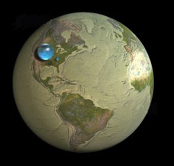
As we can see today, that wasn’t the case.

Planets such as Uranus and Neptune that formed beyond the snow line are composed of tens of percents of water. But Earth doesn’t have much water, and that has always been a puzzle.”

– Rebecca Martin, Space Telescope Science Institute 

A study led astrophysicists Rebecca Martin and Mario Livio of the Space Telescope Science Institute took another look at how the snow line in our solar system must have evolved, and found that, in their models, Earth was never inside the line. Instead it stayed within a warmer, drier region inside of the snow line, and away from the ice.

“Unlike the standard accretion-disk model, the snow line in our analysis never migrates inside Earth’s orbit,” Livio said. “Instead, it remains farther from the Sun than the orbit of Earth, which explains why our Earth is a dry planet. In fact, our model predicts that the other innermost planets, Mercury, Venus, and Mars, are also relatively dry. ”

Read: Rethinking the Source of Earth’s Water

The standard model states that in the early days of a protoplanetary disk’s formation ionized material within it gradually falls toward the star, drawing the icy, turbulent snow line region inward. But this model depends upon the energy of an extremely hot star fully ionizing the disk — energy that a young star, like our Sun was, just didn’t have.

“We said, wait a second, disks around young stars are not fully ionized,” Livio said. “They’re not standard disks because there just isn’t enough heat and radiation to ionize the disk.”
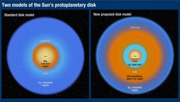

“Astrophysicists have known for quite a while that disks around young stellar objects are NOT standard accretion disks (namely, ones that are ionized and turbulent throughout),” added Dr. Livio in an email to Universe Today. “Disk models with dead zones have been constructed by many people  for many years. For some reason, however, calculations of the evolution of the snow line largely continued to use the standard disk models.”

Without fully ionized disk, the material is not drawn inward. Instead it orbits the star, condensing gas and dust into a “dead zone”  that blocks outlying material from coming any closer. Gravity compresses the dead zone material, which heats up and dries out any ices that exist immediately outside of it. Based on the team’s research it was in this dry region that Earth formed.

The rest, as they say, is water under the bridge.

The team’s results have been accepted for publication in the journal Monthly Notices of the Royal Astronomical Society.

Read the release on the Hubble news site here, and see the full paper here.

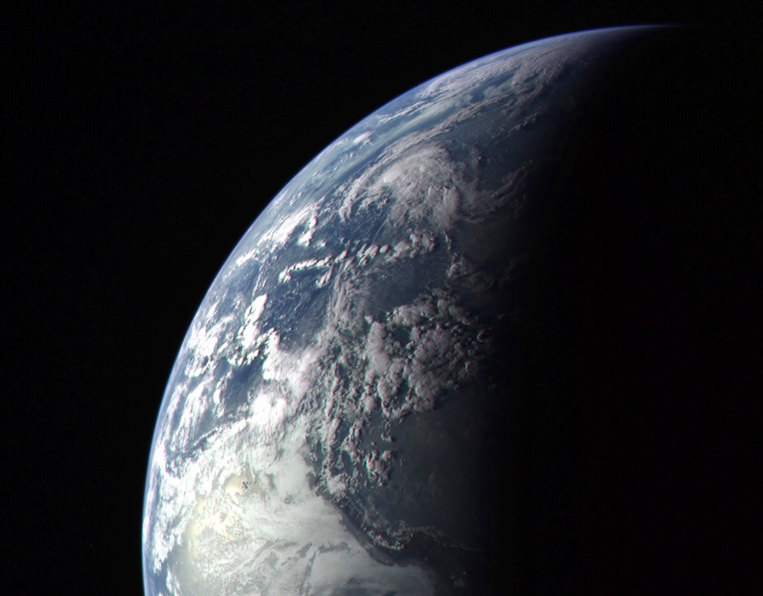
Lead image: Earth as seen by MESSENGER spacecraft before it left for Mercury in 2004. NASA/Johns Hopkins University Applied Physics Laboratory/Carnegie Institution of Washington. Disk model image: NASA, ESA, and A. Feild (STScI). Earth water volume image:  Howard Perlman, USGS; globe illustration by Jack Cook, Woods Hole Oceanographic Institution (©); Adam Nieman.

Fifth Moon Found Around Pluto

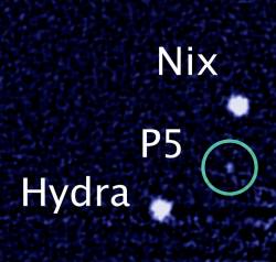
This just in! Astronomers working with the Hubble Space Telescope have spotted a new moon around distant Pluto, bringing the known count up to 5. The image above was released by NASA just minutes ago, showing the Pluto system with its newest member, P5.

This news comes just a couple of weeks shy of the one-year anniversary of the announcement of Pluto’s 4th known moon, still currently named “P4”.

The news was shared this morning by an undoubtedly excited Alan Stern of the Southwest Research Institute (SwRI) on Twitter.

Astronomers estimate P5 to be between 6 and 15 miles (9.6 to 24 km) in diameter. It orbits Pluto in the same plane as the other moons — Charon, Nix, Hydra and P4.

“The moons form a series of neatly nested orbits, a bit like Russian dolls,” said team lead Mark Showalter of the SETI Institute.

A mini-abstract of an upcoming paper lists image sets acquired on 5 separate occasions in June and July. According to the abstract, P5 is 4% as bright as Nix and 50% as bright as P4.

The satellite’s mean magnitude is V = 27.0 +/- 0.3, making it 4 percent as bright as Pluto II (Nix) and half as bright as S/2011 (134340) 1. The diameter depends on the assumed geometric albedo: 10 km if p_v = 0.35, or 25 km if p_v =0.04. The motion is consistent with a body traveling on a near-circular orbit coplanar with the other satellites. The inferred mean motion is 17.8 +/- 0.1 degrees per day (P = 20.2 +/- 0.1 days), and the projected radial distance from Pluto is 42000 +/- 2000 km, placing P5 interior to Pluto II (Nix) and close to the 1:3 mean motion resonance with Pluto I (Charon).

The new detection will help scientists navigate NASA’s New Horizons spacecraft through the Pluto system in 2015, when it makes an historic and long-awaited high-speed flyby of the distant world.

See the news release from NASA here.

(H/T to Ray Sanders at DearAstronomer.com)

Top image: NASA, ESA and M. Showalter (SETI Institute)

The Return of the Rings!

Now that Cassini has gone off on a new trajectory taking it above and below the equatorial plane of Saturn, we’re back to getting some fantastic views of the rings — the likes of which haven’t been seen in over two and a half years!

The image above shows portions of the thin, ropy F ring and the outer A ring, which is split by the 202-mile (325-km) -wide Encke gap. The shepherd moon Pan can be seen cruising along in the gap along with several thin ringlets. Near the A ring’s outer edge is a narrower space called the Keeler gap — this is the home of the smaller shepherd moon Daphnis, which isn’t visible here (but is one of my personal favorites!)

The scalloped pattern on the inner edge of the Encke gap downstream from Pan and a spiral pattern moving inwards from that edge are created by the 12.5-mile-wide (20-km-wide) moon’s gravitational influence.

Other features that have returned for an encore performance are the so-called propellers, spiral sprays of icy ring material created by tiny micro-moons within the rings. Individually too small to discern (less than half a mile in diameter) these propeller moons kick up large clumps of reflective ring particles with their gravity as they travel through the rings, revealing their positions.

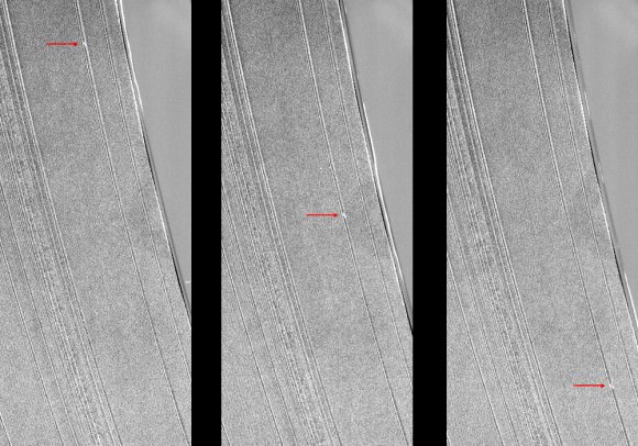
The three images above show a propeller within the A ring. Nicknamed “Sikorsky” after Russian-American aviator Igor Sikorsky, the entire structure is about 30 miles (50 km) across and is one of the more well-studied propellers.

Scientists are eager to understand the interactions of propellers in Saturn’s rings as they may hold a key to the evolution of similar systems, such as solar systems forming from disks of matter.

See a video of a propeller orbiting within the rings here, and here’s an image of one that’s large enough to cast a shadow!

“One of the main contributing factors to the enormous success we on the Cassini mission have enjoyed in the exploration of Saturn is the capability to view the planet and the bodies around it from a variety of directions,” Cassini Imaging Team Leader Carolyn Porco wrote earlier today. “Setting the spacecraft high into orbit above Saturn’s equator provides us direct views of the equatorial and middle latitudes on the planet and its moons, while guiding it to high inclination above the equator plane affords the opportunity to view the polar regions of these bodies and be treated to vertigo-inducing shots of the planet’s glorious rings.”

As always, keep up with the latest Cassini news on the mission site here, and read more about these images on the CICLOPS imaging team page here.

Image credits: NASA / JPL / Space Science Institute.


An Epic Crater Called Odysseus

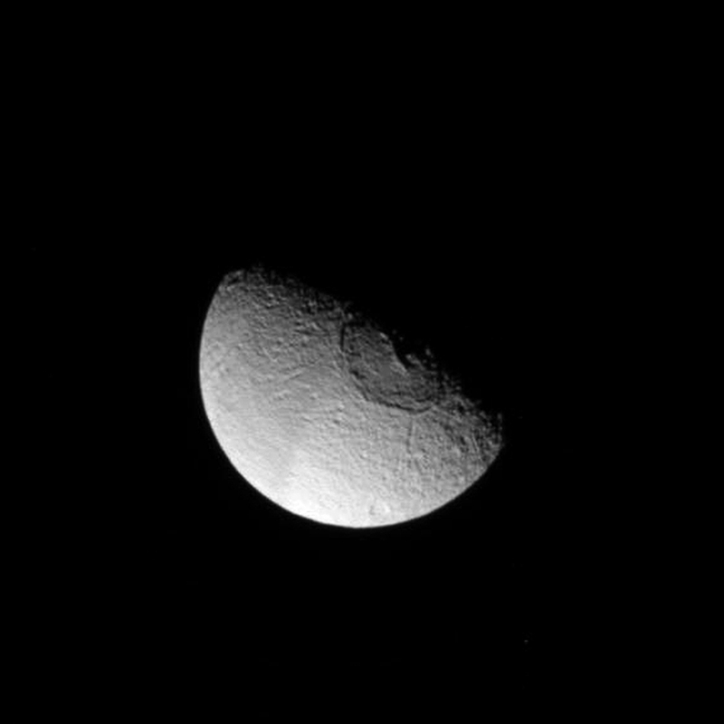
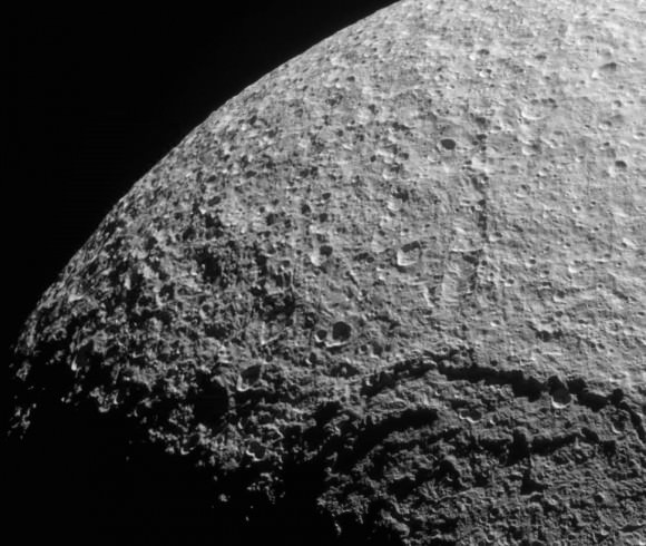
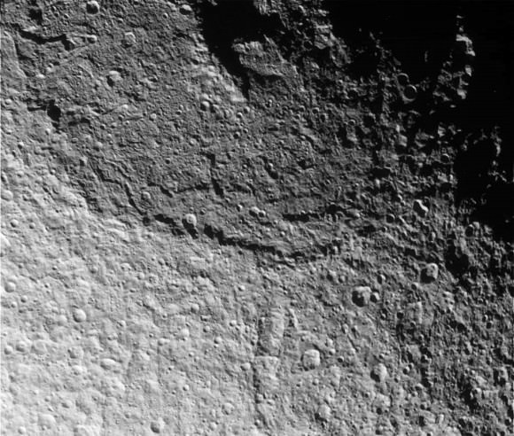
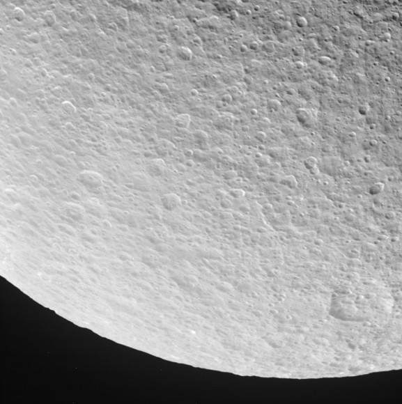
On June 28 NASA’s Cassini spacecraft passed by Tethys, a 1,062-kilometer (662-mile) -wide moon of Saturn that’s made almost entirely of ice. Tethys is covered in craters of all sizes but by far the most dramatic of all is the enormous Odysseus crater, which spans an impressive 450 kilometers (280 miles) of the moon’s northern hemisphere — nearly two-fifths of its entire diameter!

In fact, whatever struck Tethys in the distant past probably should have shattered it into pieces… but didn’t.

Tethys likely held itself together because when the impact occurred that formed Odysseus, the moon was still partially molten. It was able to absorb some of the energy of the impact and thus avoid disintegration — although it was left with a quite the battle scar as an eternal reminder.

The images below are raw images from Cassini’s latest pass of Tethys, showing the moon’s rugged terrain and portions of Odysseus from a distance of 68,521 kilometers (42,577 miles).

The central peak of Odysseus has collapsed, leaving a depression — another indication that the moon wasn’t entirely solid at the time of impact.

Tethys orbits Saturn at a distance of 294,660 kilometers (183,100 miles), about 62,000 miles closer than the Moon is from Earth. Such a close proximity to Saturn subjects Tethys to tidal forces, the frictional heating of which likely helped keep it from cooling and solidifying longer than more distant moons. As a result Tethys appears somewhat less cratered than sister moons Rhea and Dione, which still bear the marks of their earliest impacts… although looking at the region south of Odysseus it’s hard to image a more extensively-cratered place.

Tethys is just another reminder of the violent place our solar system can be. Find out more about Tethys on the Cassini mission site here.

Image credits: NASA/JPL/Space Science Institute. Edited by J. Major. Images have not been calibrated or validated, and each has been level-adjusted and sharpened to bring out surface detail, and in some areas deinterlacing was used to remove linear raw image artifacts.