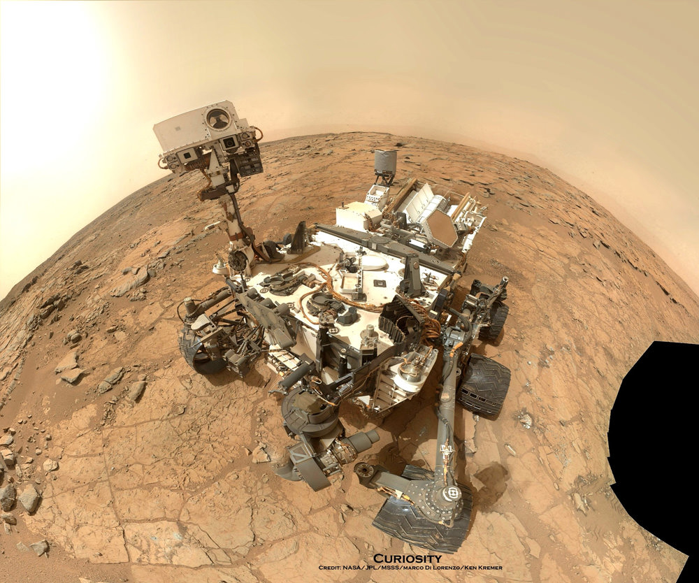
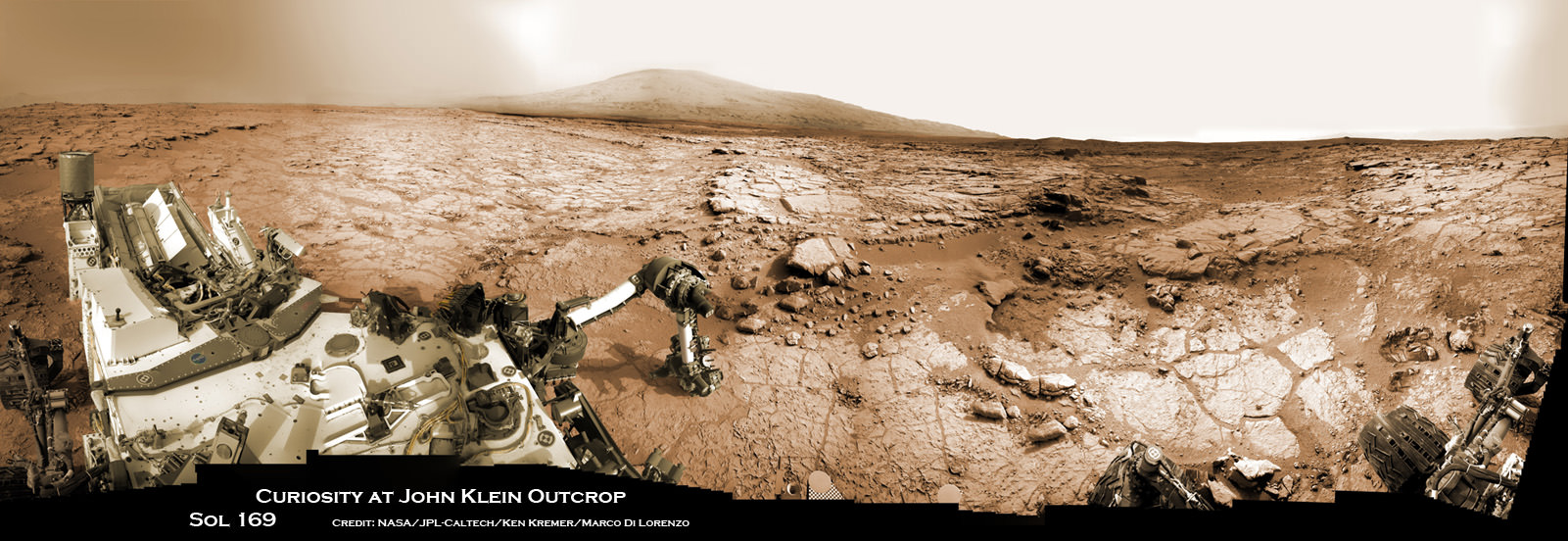
NASA's Mars rover Curiosity took this self-portrait, composed of more than 50 images using its robotic arm-mounted MAHLI camera, on Feb. 3, 2013. The image shows Curiosity at the John Klein drill site. A drill hole is visible at bottom left. Credit: NASA / JPL / MSSS / Marco Di Lorenzo / Ken Kremer- kenkremer.com
CAPE CANAVERAL, FL – NASA’s car sized CuriosityMars rover has resumed full science operations and driving following a six day long halt to research activities due to concerns about an electrical power system glitch, which have now been resolved.
On Nov. 17, engineers noticed a fluctuation in voltage on Curiosity that caused the robots handlers to stop science activities and driving towards mysterious Mount Sharp while they searched for the root cause of the electrical issue.
NASA says that the voltage change did not impact the rovers safety or health and the team was acting out of an abundance of caution while investigating the situation from millions of miles away back on Earth.
“The vehicle’s electrical system has a “floating bus” design feature to tolerate a range of voltage differences between the vehicle’s chassis — its mechanical frame — and the 32-volt power lines that deliver electricity throughout the rover. This protects the rover from electrical shorts,” NASA said in a statement.
Curiosity’s voltage level had been about 11 volts since landing day and had declined to about 4 volts on Nov. 17. The electrical issue did not trigger the rover to enter a safe-mode status.
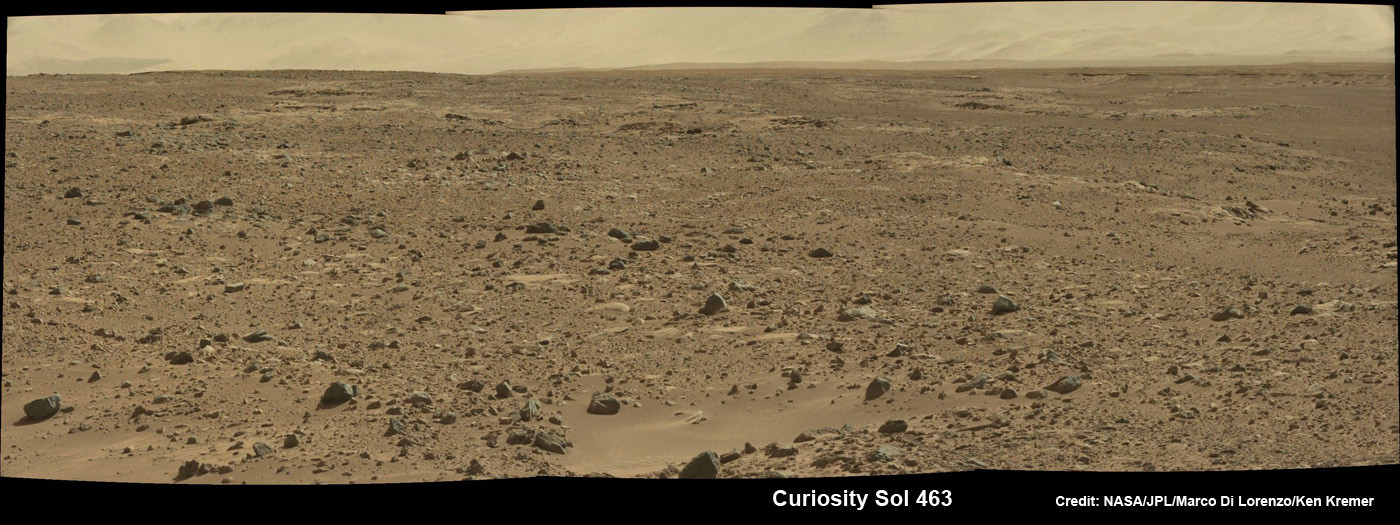
Curiosity scans the Martian landscape to the distant rim of Gale Crater landing site on Sol 463, November 2013. Credit: NASA / JPL / MSSS / Marco Di Lorenzo / Ken Kremer- kenkremer.com
Engineers amassed a list of possible causes for the voltage change while suspending science operations and roving across the Martian crater floor where Curiosity landed nearly a year and a half ago in August 2012.
“We made a list of potential causes, and then determined which we could cross off the list, one by one,” said rover electrical engineer Rob Zimmerman of NASA’s Jet Propulsion Laboratory, Pasadena, Calif.
NASA says that the likely cause is an internal short stemming from the Radioisotope Thermoelectric Generator (RTG) – the rovers nuclear power source.
RTG’s have been commonly used on many NASA missions that also experienced occasional shorts and that had no long term impact or loss of capability on their flights.
“This type of intermittent short has been seen in similar RTGs, including the one on the Cassini spacecraft, which has been orbiting Saturn for years. The rover electronics are designed to operate at variable power supply voltages, so this is not a major problem,” says Curiosity team member Ken Herkenhoff of the USGS in a mission update.
The voltage level had returned its normal level of 11 volts on its own by Nov. 23, when the team had decided to resume science operations.
So it is possible that the same type of intermittent voltage change could recur in the future.
Meanwhile the rover has resumed her epic trek to Mount Sharp and is expected to arrive at the base of the mountain sometime in mid-2014.
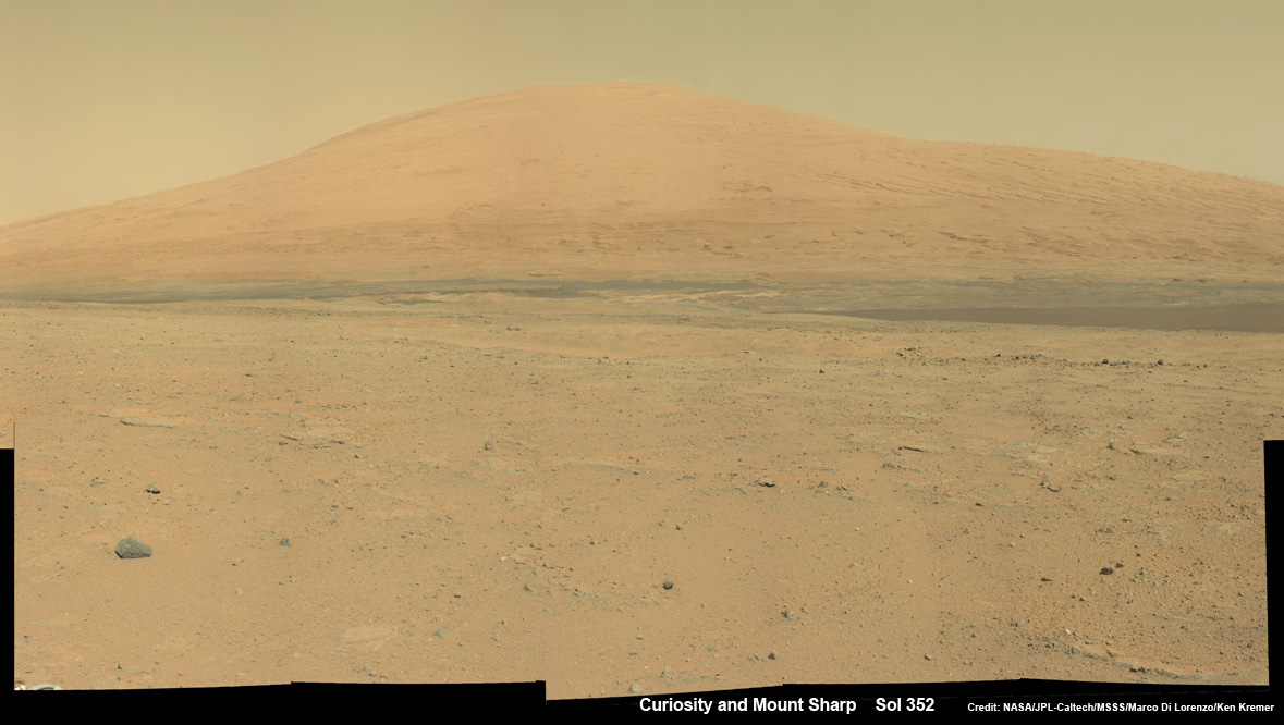
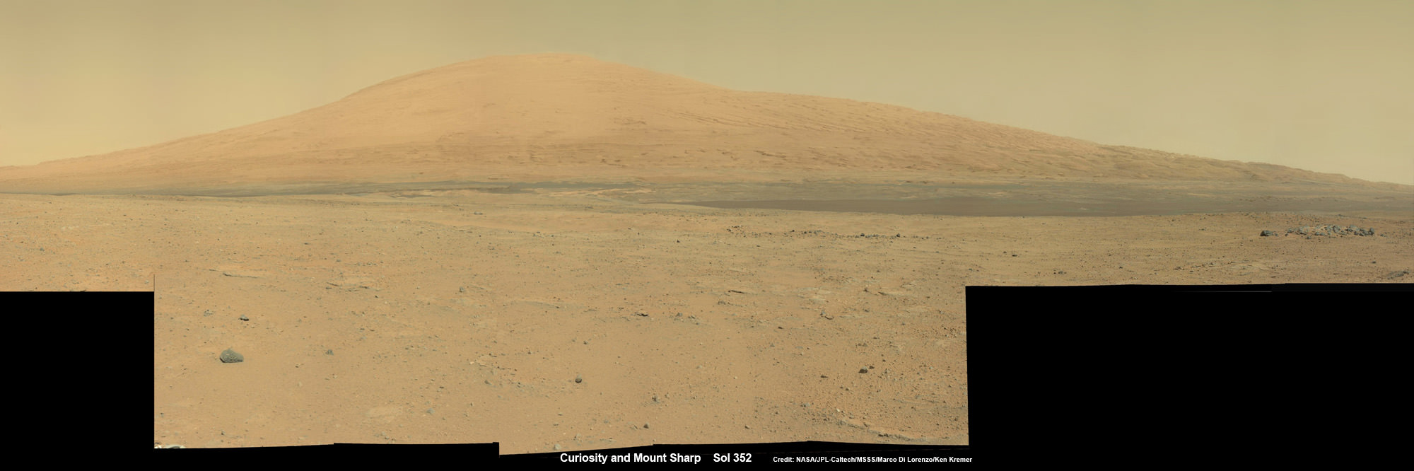
Curiosity Spies Mount Sharp – her primary destination. Curiosity will ascend mysterious Mount Sharp and investigate the sedimentary layers searching for clues to the history and habitability o the Red Planet of billions of years. This mosaic was assembled from Mastcam camera images taken on Sol 352 (Aug 2, 2013). Credit: NASA/JPL-Caltech/MSSS/ Marco Di Lorenzo/Ken Kremer
This past weekend, the robot delivered additional portions of powdered rock to the CheMin and SAM labs inside the rover. The sample was collected 6 months ago after drilling into a rock nicknamed “Cumberland” and will supplement prior measurements.
Curiosity has already accomplished her primary science goal of discovering a habitable zone at her landing site.
Scientists expect to broaden the region of Martian habitability once the 1 ton robot begins the ascent of Mount Sharp to investigate the sedimentary layers in the lower reaches of the towering 3 mile (5 km) high mountain, that record Mars geologic and climatic history over a time span of billions of years.
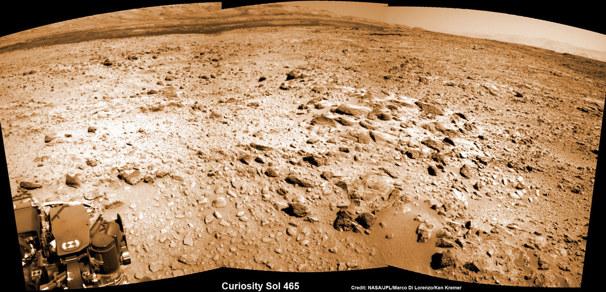
Curiosity looks to the base of Mount Sharp and the Murray buttes – her ultimate climbing destination – in this mosaic assembled from navcam camera images from Sol 465, November 2013. Credit: NASA / JPL / MSSS / Marco Di Lorenzo / Ken Kremer- kenkremer.com
And as both of NASA’s rovers Curiosity and Opportunity ascend Martian mountains, they’ll be joined next September 2014 by a pair of new Martian orbiters from the US and India – MAVEN and MOM – that will significantly expand Earth’s invasion force at the Red Planet.
Stay tuned here for continuing Mars rover, MOM and MAVEN news and Ken’s MAVEN and SpaceXFalcon 9 launch reports from on site at the Kennedy Space Center press center and Cape Canaveral Air Force Station, Florida.
Star Trek actor LeVar Burton Shares MAVEN’s Story in a New NASA public service announcement (PSA). Credit: NASA
Star Trek actor LeVar Burton Shares MAVEN’s Story in a New NASA public service announcement (PSA). Credit: NASA
Watch the PSA below[/caption]
KENNEDY SPACE CENTER, FL – Star Trek actor and space enthusiast LeVar Burton stars in a new action packed NASA public service announcement (PSA) about the agency’s next Mars-bound spacecraft, the Mars Atmosphere and Volatile Evolution (MAVEN) spacecraft slated for blast off in barely two days time on Nov. 18 from the Florida Space Coast.
Burton played the beloved character of chief engineer ‘Geordi LeForge’ aboard the legendary Starship Enterprise on “Star Trek: The Next Generation” – known by audiences worldwide.
And Burton gives an appropriately other worldly narration in the NASA PSA containing exciting new animations explaining the goals and science behind the MAVEN Mars orbiter and how it will accomplish its tasks.
I was privileged to meet chief engineer ‘Geordi LeForge’ at a prior NASA launch event.
He is genuinely and truly dedicated to advancing science and education through his many STEM initiatives and participation in educational programming like the NASA PSA.
MAVEN will study the Red Planet’s atmosphere like never before and in unprecedented detail and is the first mission dedicated to studying Mars upper atmosphere.
MAVEN’s is aimed at unlocking one of the greatest Martian mysteries; Where did all the water go ? And when did the Red Planet’s water and atmosphere disappear ?
MAVEN’s suite of nine science instruments will help scientists understand the history, mechanism and causes of the Red Planet’s dramatic climate change over billions of years.
Burton’s PSA will be used at MAVEN scheduled events around the country and will also be shared on the web and social media, according to NASA. The goal is to educate the public about MAVEN and NASA’s efforts to better understand the Red Planet and the history of climate change there.
Be sure to check out the new video – below:
Video caption: NASA is returning to Mars! This NASA Public Service Announcement regarding the MAVEN mission is presented by LeVar Burton in which he shares the story about NASA’s Mars Atmosphere and Volatile Evolution mission—or MAVEN—and how it will explore Mars’ climate history and gather clues about the question scientists have been asking for decades. MAVEN will look at specific processes at Mars that led to the loss of much of its atmosphere…and MAVEN data could tell scientists a lot about the history of climate change on the Red Planet.
“NASA is thrilled to have LeVar Burton explain this mission to the greater public,” said Bert Ulrich, NASA’s multimedia liaison for film and TV collaborations in a NASA statement. “Thanks to Burton’s engaging talents and passion for space exploration, audiences of all ages will be able to share in the excitement of NASA’s next mission to Mars.”
MAVEN is targeted to launch Monday, Nov. 18 at 1:28 p.m. EST atop a United Launch Alliance Atlas V rocket from Cape Canaveral Air Force Station in Florida.
You can watch the launch live on NASA TV
Stay tuned here for continuing MAVEN and MOM news and Ken’s MAVEN launch reports from on site at the Kennedy Space Center press site.
Learn more about MAVEN, MOM, Mars rovers, Orion and more at Ken’s upcoming presentations
Nov 15-20: “MAVEN Mars Launch and Curiosity Explores Mars, Orion and NASA’s Future”, Kennedy Space Center Quality Inn, Titusville, FL, 8 PM
Dec 11: “Curiosity, MAVEN and the Search for Life on Mars”, “LADEE & Antares ISS Launches from Virginia”, Rittenhouse Astronomical Society, Franklin Institute, Phila, PA, 8 PM
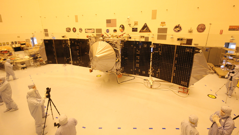
Inside the Payload Hazardous Servicing Facility at NASA's Kennedy Space Center in Florida, engineers and technicians prepare the MAVEN spacecraft for encapsulation inside its payload fairing. Credit: NASA/Kim Shiflett
KENNEDY SPACE CENTER, FL – MAVEN, NASA’s next spacecraft launching to the Red Planet in barely three days time on Nov. 18 seeks to unlock one of the greatest Martian mysteries; Where did all the water go ?
From the accumulated evidence so far scientists believe that billions of years ago, Mars was gifted with a thick atmosphere like Earth and liquid water flowed across the surface.
The Red Planet was far bluer, warmer, wetter and hospitable to life four billion years ago – truly a lot more Earth-like.
And then Mars lost its atmosphere starting somewhere around 3.5 to 3.7 Billion years ago. As the atmosphere thinned and the pressure decreased, the water evaporated and Mars evolved into the cold arid world we know today.
But why and exactly when did Mars undergo such a radical climatic transformation?
“Where did the water go and where did the carbon dioxide go from the early atmosphere? What were the mechanisms?” asks Bruce Jakosky, MAVEN’s Principal Investigator from the University of Colorado at Boulder
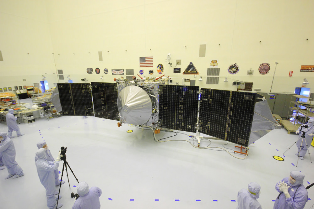
MAVEN is NASA’s next Mars orbiter and is due to blastoff on Nov. 18 from Cape Canaveral, Florida. It will study the evolution of the Red Planet’s atmosphere and climate. Universe Today visited MAVEN inside the clean room at the Kennedy Space Center. With solar panels unfurled, this is exactly how MAVEN looks when flying through space and circling Mars. Credit: Ken Kremer/kenkremer.com
Although there are lots of theories, NASA’s MAVEN Mars orbiter – which stands for Mars Atmosphere and Volatile Evolution – is the first real attempt to investigating these fundamental questions that hold the key to solving the Martian mysteries perplexing the science community.
“We don’t know the driver of the change,” explains Jakosky.
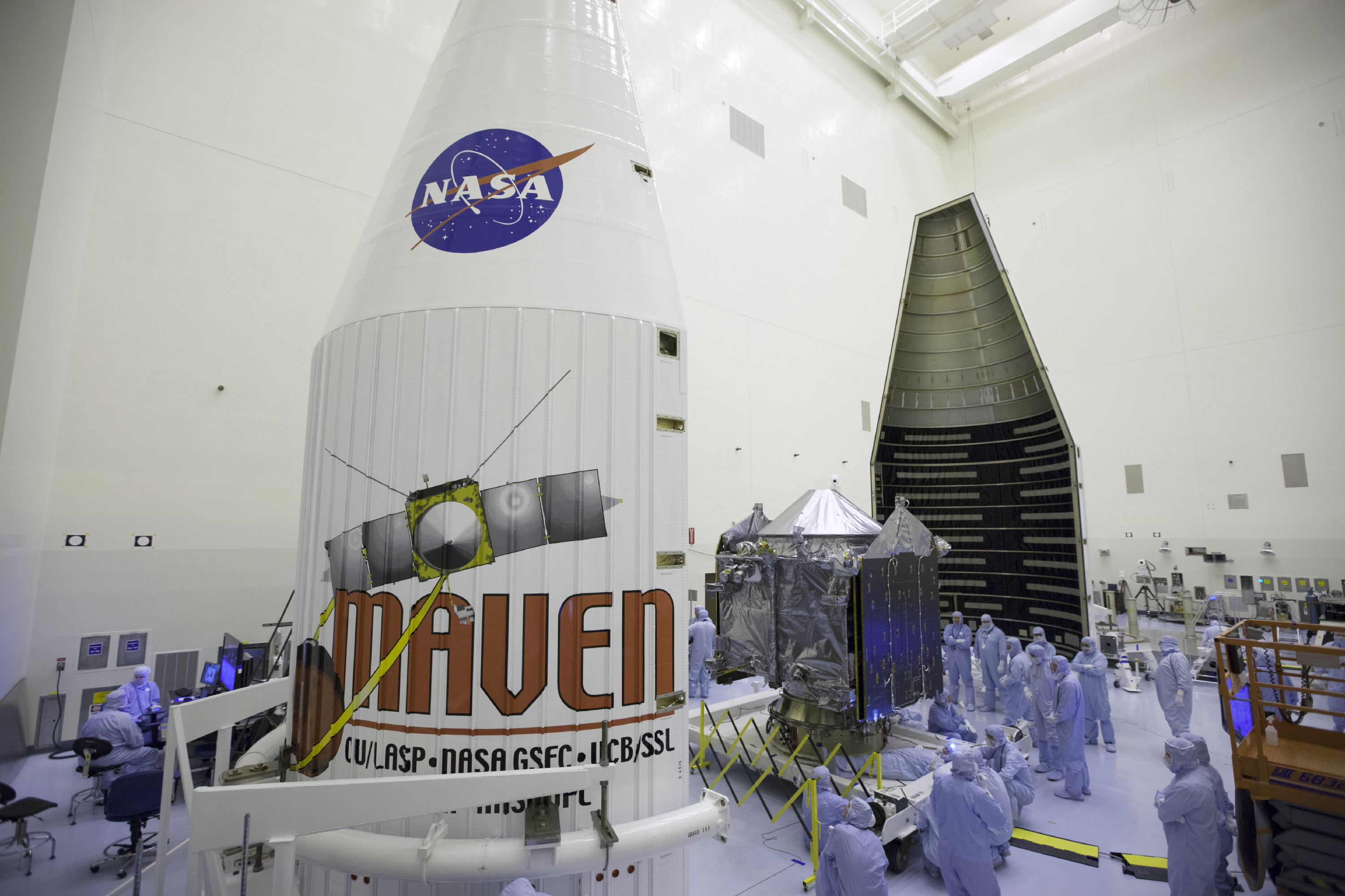
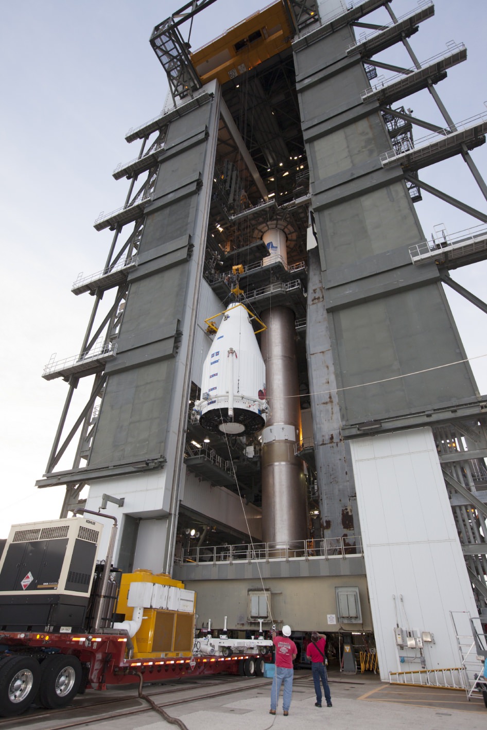
MAVEN Mated to Atlas. On Nov. 8,2013, NASA’s Mars Atmosphere and Volatile Evolution, or MAVEN spacecraft, is hoisted to the top of a United Launch Alliance Atlas V rocket at the Vertical Integration Facility at Launch Complex 41. Credit: NASA/Kim ShiflettBy studying and understanding specific processes in the upper atmosphere of Mars, MAVEN’s seeks to determine how and why Mars atmosphere and water disappeared billions of years ago and what effect that had on the history of climate change and habitability.
“The major questions about the history of Mars center on the history of its climate and atmosphere and how that’s influenced the surface, geology and the possibility for life,” says Jakosky.
MAVEN is equipped with three instrument suites holding nine science instruments
MAVEN will focus on understanding the history of the atmosphere, how the climate has changed through time, and how that influenced the evolution of the surface and the potential for habitability by microbes on Mars.”
“That’s what driving our exploration of Mars with MAVEN,” said Jakosky
The 5,400 pound MAVEN probe carries nine sensors in three instrument suites.
MAVEN Spacecraft Positioned Atop Atlas V Rocket at Launch Complex 41 on Cape Canaveral. Credit: NASAThe Particles and Fields Package, provided by the University of California at Berkeley with support from CU/LASP and NASA’s Goddard Space Flight Center in Greenbelt, Md., contains six instruments to characterize the solar wind and the ionosphere of Mars. The Remote Sensing Package, built by CU/LASP, will determine global characteristics of the upper atmosphere and ionosphere. The Neutral Gas and Ion Mass Spectrometer, built by Goddard, will measure the composition of Mars’ upper atmosphere.
I personally inspected MAVEN inside the clean room at the Kennedy Space Center on Sept. 27 with fellow journalists when the solar arrays were fully unfurled.
The probe spanned 37 feet in length from wingtip to wingtip.
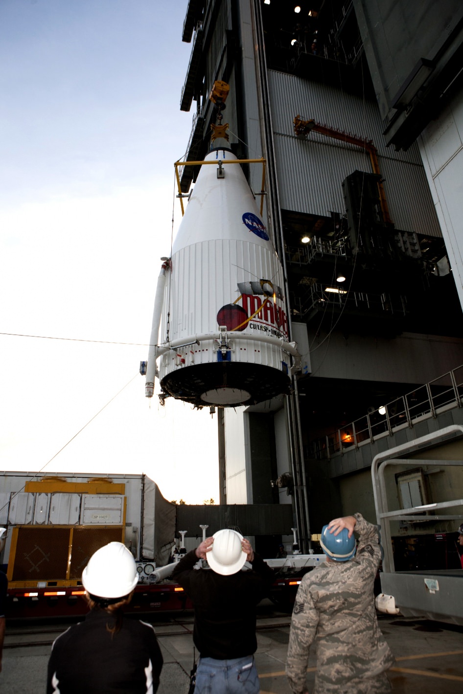
Since then MAVEN has been folded and encapsulated inside the payload fairing, transported to the pad at Launch Complex 41 and hoisted on top of the Atlas V rocket on Cape Canaveral Air Force Station (CCAFS) in Florida.
The $671 Million MAVEN spacecraft has been powered on and awaits liftoff.
MAVEN is the second of two Mars bound probes launching from Earth this November.
Learn more about MAVEN, MOM, Mars rovers, Orion and more at Ken’s upcoming presentations
Nov 14-20: “MAVEN Mars Launch and Curiosity Explores Mars, Orion and NASA’s Future”, Kennedy Space Center Quality Inn, Titusville, FL, 8 PM
Dec 11: “Curiosity, MAVEN and the Search for Life on Mars”, “LADEE & Antares ISS Launches from Virginia”, Rittenhouse Astronomical Society, Franklin Institute, Phila, PA, 8 PM
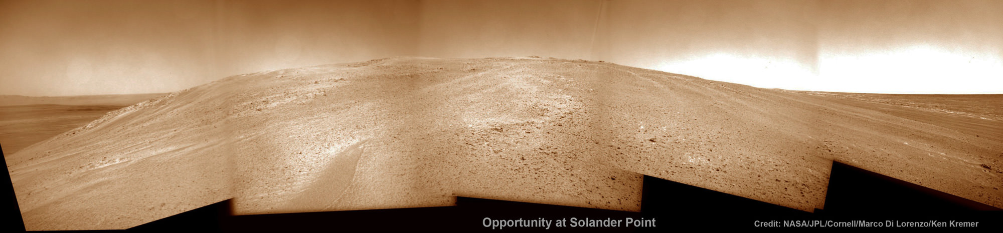
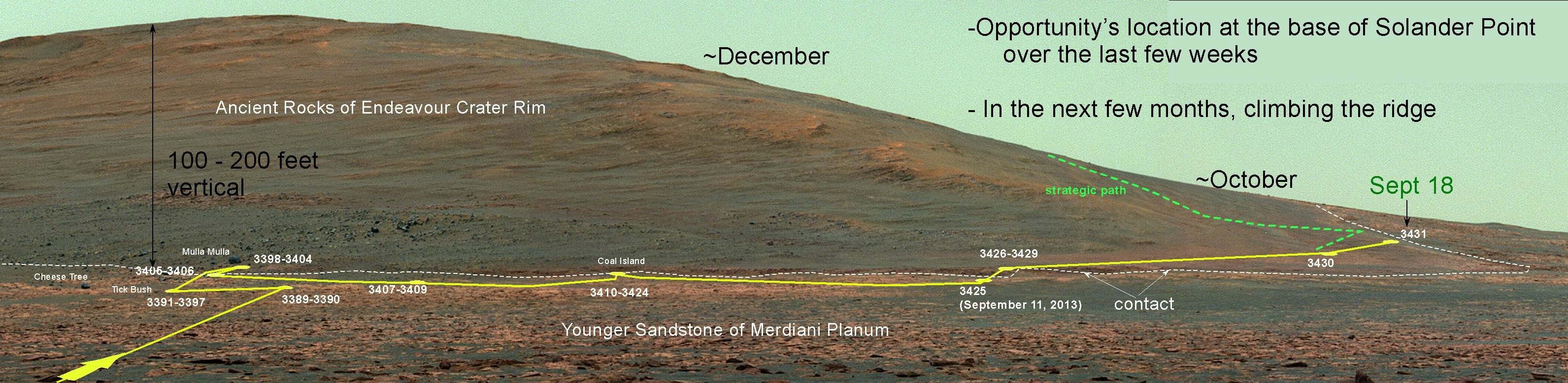
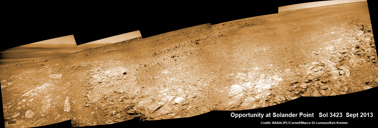
Opportunity starts Martian Mountaineering. NASA’s Opportunity rover captured this southward uphill panoramic mosaic on Oct. 21, 2013 (Sol 3463) after beginning to ascend the northwestern slope of "Solander Point" on the western rim of Endeavour Crater - her 1st mountain climbing adventure. The northward-facing slope will tilt the rover's solar panels toward the sun in the southern-hemisphere winter sky, providing an important energy advantage for continuing mobile operations through the upcoming winter. Assembled from Sol 3463 navcam raw images by Marco Di Lorenzo and Ken Kremer. Credit: NASA/JPL/Cornell/Marco Di Lorenzo/Ken Kremer
Opportunity starts Martian Mountaineering
NASA’s Opportunity rover captured this southward uphill panoramic mosaic on Oct. 21, 2013 (Sol 3463) after beginning to ascend the northwestern slope of “Solander Point” on the western rim of Endeavour Crater – her 1st mountain climbing adventure. The northward-facing slope will tilt the rover’s solar panels toward the sun in the southern-hemisphere winter sky, providing an important energy advantage for continuing mobile operations through the upcoming winter. Assembled from Sol 3463 navcam raw images by Marco Di Lorenzo and Ken Kremer.
Credit: NASA/JPL/Cornell/Marco Di Lorenzo/Ken Kremer Story and imagery updated[/caption]
“This is our first real Martian mountaineering with Opportunity,” said the principal investigator for the rover, Steve Squyres of Cornell University, Ithaca, N.Y.
And it happened right in the middle of the utterly chaotic US government shutdown ! – that seriously harmed some US science endeavors. And at a spot destined to become a science bonanza in the months and years ahead – so long as she stays alive to explore ever more new frontiers.
On Oct. 8, mission controllers on Earth directed the nearly decade old robot to start the ascent of Solander Point – the northern tip of the tallest hill she has encountered after nearly 10 Earth years on Mars.
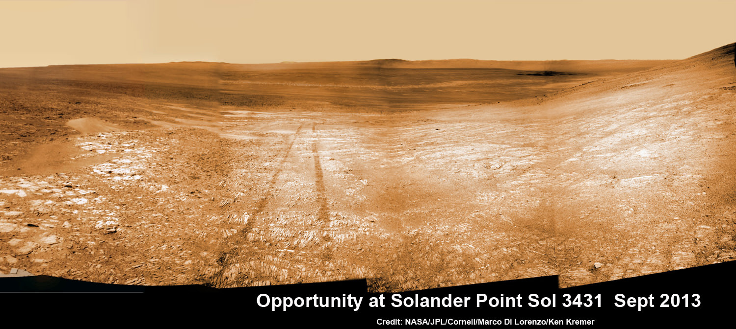
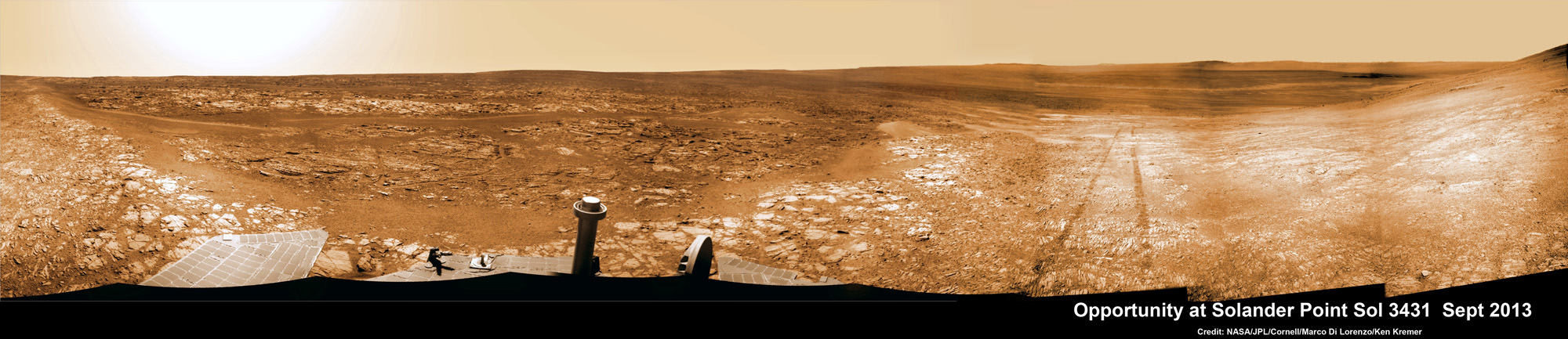
Opportunity starts scaling Solander Point – her1st mountain climbing goal. See the tilted terrain and rover tracks in this mosaic view from Solander Point peering across the vast expanse of huge Endeavour Crater. Opportunity will ascend the mountain looking for clues indicative of a Martian habitable environment. This navcam camera mosaic was assembled from raw images taken on Sol 3431 (Sept.18, 2013). Credit: NASA/JPL/Cornell/Marco Di Lorenzo/Ken Kremer (kenkremer.com). See the complete panoramic view below
The northward-facing slopes at Solander also afford another major advantage. They will tilt the rover’s solar panels toward the sun in the southern-hemisphere winter sky, providing an important energy boost enabling continued mobile operations through the upcoming frigidly harsh winter- her 6th since landing in 2004.
Opportunity will first explore outcrops on the northwestern slopes of Solander Point in search of the chemical ingredients required to sustain life before gradually climbing further uphill to investigate intriguing deposits distributed amongst its stratographic layers.
The rover will initially focus on outcrops located in the lower 20 feet (6 meters) above the surrounding plains on slopes as steep as 15 to 20 degrees.
Opportunity starts scaling Solander Point – her 1st mountain climbing goal. See the tilted terrain and rover tracks in this panoramic view from Solander Point peering across the vast expanse of huge Endeavour Crater. Opportunity will ascend the mountain looking for clues indicative of a Martian habitable environment. This navcam camera mosaic was assembled from raw images taken on Sol 3431 (Sept.18, 2013). Credit: NASA/JPL/Cornell/Marco Di Lorenzo/Ken Kremer (kenkremer.com).
At some later time, Opportunity may ascend Solander farther upward, which peaks about 130 feet (40 meters) above the crater plains.
“We expect we will reach some of the oldest rocks we have seen with this rover — a glimpse back into the ancient past of Mars,” says Squyres.
NASA’s powerful Mars Reconnaissance Orbiter (MRO) circling overhead recently succeeded in identifying clay-bearing rocks during new high resolution survey scans of Solander Point!
As I reported previously, the specially collected high resolution observations by the orbiters Compact Reconnaissance Imaging Spectrometer for Mars (CRISM) were collected in August and being analyzed by the science team. They will be used to direct Opportunity to the most productive targets of interest
“CRISM data were collected,” Ray Arvidson told Universe Today. Arvidson is the mission’s deputy principal scientific investigator from Washington University in St. Louis, Mo.
“They show really interesting spectral features in the [Solander Point] rim materials.”
NASA’s Opportunity rover captured this southward uphill view on Oct. 21, 2013 after beginning to ascend the northwestern slope of “Solander Point” on the western rim of Endeavour Crater. The northward-facing slope will tilt the rover’s solar panels toward the sun in the southern-hemisphere winter sky, providing an important energy advantage for continuing mobile operations through the upcoming winter. Credit: NASA/JPL
The new CRISM survey from Mars orbit yielded mineral maps which vastly improves the spectral resolution – from 18 meters per pixel down to 5 meters per pixel.
This past spring and summer, Opportunity drove several months from the Cape York rim segment to Solander Point.
“At Cape York, we found fantastic things,” Squyres said. “Gypsum veins, clay-rich terrain, the spherules we call newberries. We know there are even larger exposures of clay-rich materials where we’re headed. They might look like what we found at Cape York or they might be completely different.”
The summit of Solander Point
Opportunity rover captured mosaic on Oct. 21, 2013 (Sol 3463) after beginning to ascend the northwestern slope of “Solander Point” on the western rim of Endeavour Crater – her 1st mountain climbing adventure. Assembled from Sol 3463 pancam high resolution raw images by Marco Di Lorenzo and Ken Kremer. Credit: NASA/JPL/Cornell/Marco Di Lorenzo/Ken Kremer
Clay minerals, or phyllosilicates, form in neutral water that is more conducive to life.
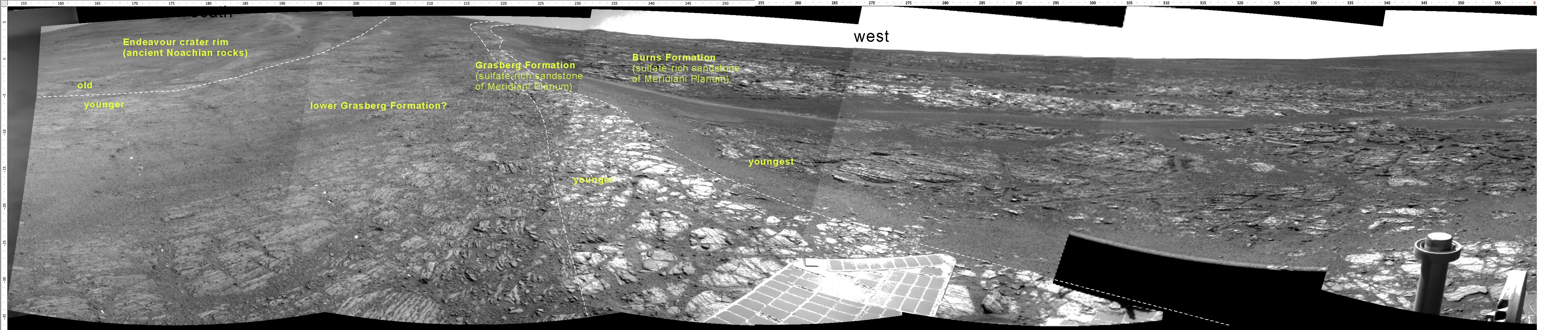
At the base of Solander, the six wheeled rover discovered a transition zone between a sulfate-rich geological formation and an older formation. Sulfate-rich rocks form in a wet environment that was very acidic and less favorable to life.
Solander Point is located at the western rim of the vast expanse of Endeavour crater – some 22 kilometers (14 miles) in diameter.
Today marks Opportunity’s 3466th Sol or Martian Day roving Mars – for what was expected to be only a 90 Sol mission.
So far she has snapped over 185,200 amazing images on the first overland expedition across the Red Planet.
Her total odometry stands at over 23.89 miles (38.45 kilometers) since touchdown on Jan. 24, 2004 at Meridiani Planum.
On the opposite side of Mars, Opportunity’s younger sister rover Curiosity is trekking towards gigantic Mount Sharp and recently discovered a patch of pebbles formed by flowing liquid water.
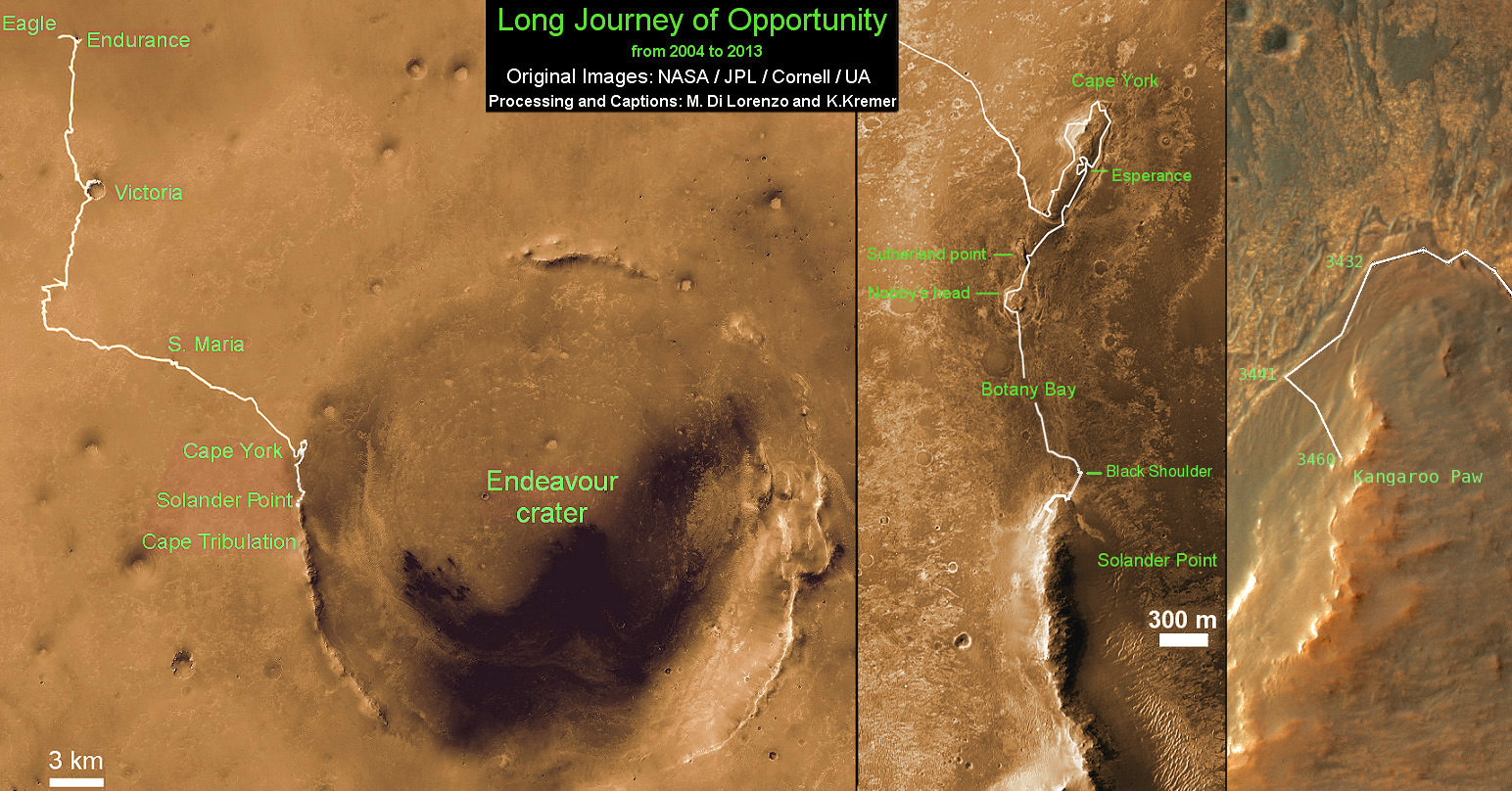
Traverse Map for NASA’s Opportunity rover from 2004 to 2013
This map shows the entire path the rover has driven during nearly 10 years and over 3460 Sols, or Martian days, since landing inside Eagle Crater on Jan 24, 2004 to current location ascending her 1st Martian Mountain – Solander Point – at the western rim of Endeavour Crater. Opportunity discovered clay minerals at Esperance – indicative of a habitable zone and seeks clay minerals now at Solander. Credit: NASA/JPL/Cornell/ASU/Marco Di Lorenzo/Ken Kremer
The upcoming Nov. 18 blastoff of NASA’s new MAVEN Mars orbiter is threatened by the today’s US Federal Government shutdown. Launch processing work has now ceased! Spacecraft preps had been in full swing when MAVEN was unveiled to the media, including Universe Today, inside the cleanroom at the Kennedy Space Center on Sept. 27, 2013. Credit: Ken Kremer/kenkremer.com
The upcoming Nov. 18 blastoff of NASA’s new MAVEN Mars orbiter is threatened by today’s US Federal Government shutdown. Launch processing work has now ceased! Spacecraft preps had been in full swing when MAVEN was unveiled to the media, including Universe Today, inside the clean room at the Kennedy Space Center on Sept. 27, 2013. With solar panels unfurled, this is exactly how MAVEN looks when flying through interplanetary space and orbiting Mars.
Credit: Ken Kremer/kenkremer.com[/caption]
KENNEDY SPACE CENTER, FL – The upcoming Nov. 18 blastoff of NASA’s next mission to Mars – the “breathtakingly beautiful” MAVEN orbiter – is threatened by today’s (Oct. 1) shutdown of the US Federal Government. And the team is very “concerned”, although not yet “panicked.”
MAVEN’s on time launch is endangered by the endless political infighting in Washington DC. And the bitter gridlock could cost taxpayers tens of millions of dollars or more on this mission alone!
Why? Because launch preparations at NASA’s Kennedy Space Center (KSC) have ceased today when workers were ordered to stay home, said the missions top scientist in an exclusive to Universe Today.
“MAVEN is shut down right now!” Prof. Bruce Jakosky, MAVEN’s principal Investigator, of the University of Colorado at Boulder, told Universe Today in an exclusive post shutdown update today.
“Which means that civil servants and work at government facilities [including KSC] have been undergoing an orderly shutdown,” Jakosky told me.
The nominal interplanetary launch window for NASA’s $650 Million MAVEN (Mars Atmosphere and Volatile EvolutioN Mission) mission to study the Red Planet’s upper atmosphere only extends about three weeks until Dec. 7.
If MAVEN misses the window of opportunity this year, liftoff atop the Atlas V rocket would have to be postponed until early 2016 because the Earth and Mars only align favorably for launches every 26 months.
Any launch delay could potentially add upwards of tens to hundreds of millions of dollars in unbudgeted costs to maintain the spacecraft and rocket – and that’s money that NASA absolutely does not have in these fiscally austere times.
MAVEN spacecraft preps for Nov. 18 launch to Mars were on schedule when it was unveiled to the media inside the clean room at the Kennedy Space Center on Sept. 27, 2013. The Oct. 1 US Government shutdown has stopped all work. Credit: Ken Kremer/kenkremer.com
MAVEN and much of NASA are not considered “essential” – despite having responsibility for hundreds of ongoing mission operations costing tens of billions of dollars that benefit society here on Earth. So about 97% of NASA employees were furloughed today.
What’s happening with the spacecraft right now?
“The hardware is being safed, meaning that it will be put into a known, stable, and safe state,” Jakosky elaborated.
Team members say there are about nine days of margin built into the processing schedule, which still includes fueling the spacecraft.
“We’ll turn back on when told that we can. We have some margin days built into our schedule,” Jakosky told me.
“We’re just inside of 7 weeks to launch, and every day is precious, so we’re certainly as anxious as possible to get back to work as quickly as possible.
And he said the team will do whatever necessary, including overtime, to launch MAVEN to the Red Planet by Dec. 7.
“The team is committed to getting to the launch pad at this opportunity, and is willing to work double shifts and seven days a week if necessary. That plus the existing margin gives us some flexibility. “
“That’s why I’m concerned but not yet panicked at this point.”
But a lengthy delay would by problematical.
“If we’re shut down for a week or more, the situation gets much more serious,” Jakosky stated.
Until today, all of the spacecraft and launch preparations had been in full swing and on target – since it arrived on Aug. 2 after a cross country flight from the Colorado assembly facility of prime contractor Lockheed Martin.
Indeed it was all smiles and thumbs up when I was privileged to personally inspect MAVEN inside the clean room at KSC a few days ago on Friday, Sept 27 during a media photo opportunity day held for fellow journalists.
Until now, “MAVEN was on schedule and under budget” said Jakosky in an interview as we stood a few feet from the nearly fully assembled spacecraft.
See my MAVEN clean room photos herein.
NASA’s MAVEN Mars orbiter, chief scientist Prof. Bruce Jakosky of CU-Boulder and Ken Kremer of Universe Today inside the clean room at the Kennedy Space Center on sept 27, 2013. MAVEN was due to launch to Mars on Nov. 18, 2013 from Florida – before the Oct. 1 government shutdown derailed plans. Credit: Ken Kremer/kenkremer.com
And in an ultra rare viewing opportunity, the solar panels were fully unfurled.
“The solar panels look exactly as they will be when MAVEN is flying in space and around Mars.”
“To be here with MAVEN is breathtaking,” Jakosky told me. “
“Its laid out in a way that was spectacular to see!”
Magnetometer science instrument juts out from MAVEN solar panel during launch processing inside the clean room at the Kennedy Space Center. Credit: Ken Kremer/kenkremer.com
If absolutely necessary it might be possible to extend the launch window a little bit beyond Dec. 7, but its uncertain and would require precise new calculations of fuel margins.
“The nominal 20-day launch period doesn’t take into account the fact that our actual mass is less than the maximum allowable mass,” Jakosky explained.
“The last day we can launch has some uncertainty, because it also requires enough fuel to get into orbit before our mission would begin to be degraded.”
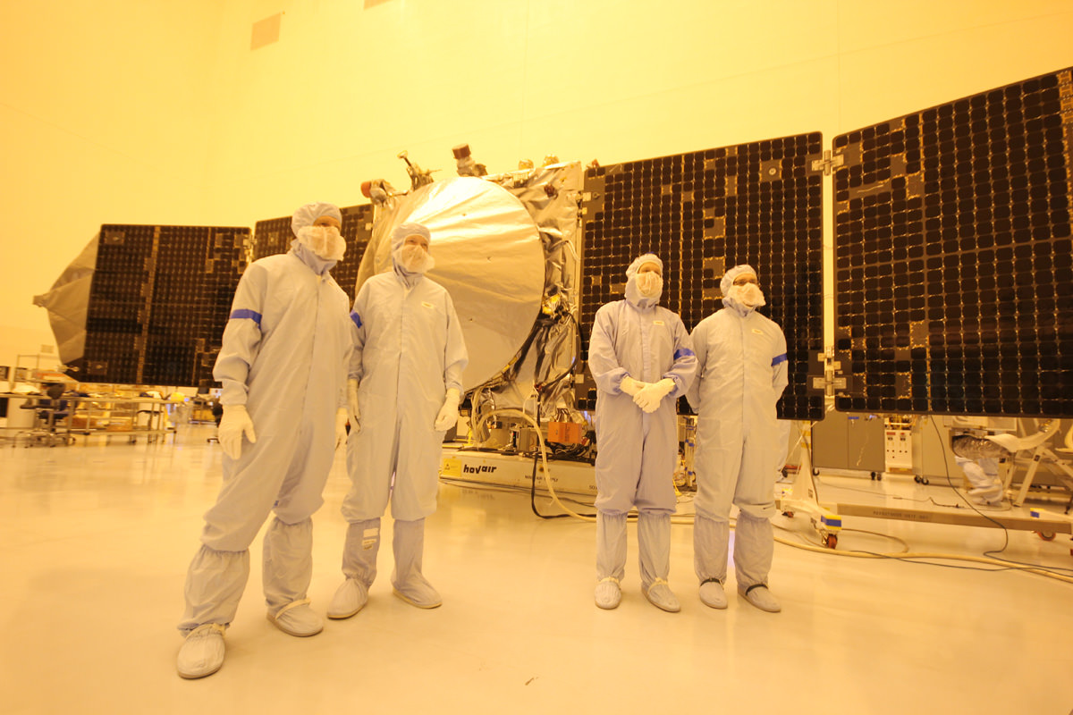
MAVEN team members, including chief scientist Bruce Jakosky (2nd from left) pose with spacecraft inside the clean room at the Kennedy Space Center on Sept. 27, 2013. Credit: Ken Kremer/kenkremer.com
It sure was breathtaking for me and all the media to stand beside America’s next Mission to Mars. And to contemplate it’s never before attempted science purpose.
“MAVENS’s goal is determining the composition of the ancient Martian atmosphere and when it was lost, where did all the water go and how and when was it lost,” said Jakosky.
That’s the key to understanding when and for how long Mars was much more Earth-like compared to today’s desiccated Red Planet.
Following a 10 month interplanetary voyage, MAVEN would fire thrusters and brake into Mars orbit in September 2014, joining NASA’s Red Planet armada comprising Curiosity, Opportunity, Mars Odyssey and Mars Reconnaissance Orbiter.
Lets all hope and pray for a short government shutdown – but the outlook is not promising at this time.
Learn more about MAVEN, Curiosity, Mars rovers, Cygnus, Antares, SpaceX, Orion, LADEE, the Govt shutdown and more at Ken’s upcoming presentations
Oct 3: “Curiosity, MAVEN and the Search for Life on Mars – (3-D)”, STAR Astronomy Club, Brookdale Community College & Monmouth Museum, Lincroft, NJ, 8 PM
Oct 8: NASA’s Historic LADEE Lunar & Antares/Cygnus ISS Rocket Launches from Virginia”; Princeton University, Amateur Astronomers Assoc of Princeton (AAAP), Princeton, NJ, 8 PM
Opportunity starts scaling Solander Point See the tilted terrain and rover tracks in this look-back mosaic view from Solander Point peering across the vast expanse of huge Endeavour Crater. Moasic assembled from navcam raw images taken on Sol 3431 (Sept.18, 2013). Credit: NASA/JPL/Cornell/Marco Di Lorenzo/Ken Kremer - kenkremer.com
Opportunity starts scaling Solander Point – her 1st mountain climbing goal
See the tilted terrain and rover tracks in this look-back mosaic view from Solander Point peering across the vast expanse of huge Endeavour Crater. Opportunity will ascend the mountain looking for clues indicative of a Martian habitable environment. This navcam camera mosaic was assembled from raw images taken on Sol 3431 (Sept.18, 2013). Credit: NASA/JPL/Cornell/Marco Di Lorenzo/Ken Kremer (kenkremer.com). See the complete panoramic view below[/caption]
NASA’s intrepid Opportunity rover has begun an exciting new phase in her epic journey – the ascent of Solander Point, the first mountain she will ever climb, after roving the Red Planet for nearly a decade. See the rovers tilted look-back view in our Sol 3431 mosaic above.
Furthermore, ground breaking discoveries providing new clues in search of the chemical ingredients required to sustain life are sure to follow as the rover investigates intriguing stratographic deposits distributed amongst Solander’s hills layers.
Why ? Because NASA’s powerful Mars Reconnaissance Orbiter (MRO) circling overhead has also recently succeeded in collecting “really interesting” new high resolution survey scans of Solander Point! Read my prior pre-survey account – here.
So says Ray Arvidson, the mission’s deputy principal scientific investigator, in an exclusive Opportunity news update to Universe Today. The new MRO data are crucial for targeting the rover’s driving in coming months.
After gaining approval from NASA, engineers successfully aimed the CRISM mineral mapping spectrometer aboard MRO at Solander Point and captured reams of new high resolution measurements that will inform the scientists about the mineralogical make up of Solander.
“CRISM data were collected,” Arvidson told Universe Today.
“They show really interesting spectral features in the [Endeavour Crater] rim materials.”
Opportunity starts scaling Solander Point – her 1st mountain climbing goal
See the tilted terrain and rover tracks in this look-back panoramic view from Solander Point peering across the vast expanse of huge Endeavour Crater. Opportunity will ascend the mountain looking for clues indicative of a Martian habitable environment. This navcam camera mosaic was assembled from raw images taken on Sol 3431 (Sept.18, 2013). Credit: NASA/JPL/Cornell/Marco Di Lorenzo/Ken Kremer (kenkremer.com).
Solander Point is an eroded ridge located along the western rim of huge Endeavour Crater where Opportunity is currently located.
“Opportunity is on the bench at the tip of Solander Point,” Ray Arvidson told Universe Today exclusively. Arvidson is the mission’s deputy principal scientific investigator from Washington University in St. Louis, Mo.
At the bench, the long lived rover has begun scaling Solander in search of science and life giving sun.
“The CRISM data are being discussed by the MER [Mars Exploration Rover] Team this week,” Arvidson told me.
And it will take some time to review and interpret the bountiful new spectral data and decide on a course of action.
“For the CRISM data analysis we will have the MER Team see the results and agree.”
Expect that analysis to take a “couple of weeks” said Arvidson.
The new CRISM survey from Mars orbit will vastly improve the spectral resolution – from 18 meters per pixel down to 5 meters per pixel.
Above is the Pancam panorama acquired on sol 3375 when Opportunity was still approaching Solander Point. On it I have plotted the subsequent drives along the east side of the point, and the location on the contact as of September 18. The approximate places where we need to be by later this fall are shown here for anyone following along. It’s a new unexplored land with new scenes. Caption and Credit: NASA/JPL/Larry Crumpler
Another important point about ‘Solander Point’ is that it also offers northerly tilted slopes that will maximize the power generation during Opportunity’s upcoming 6th Martian winter.
In order to survive those Antarctic like, ‘bone chilling” winter temperatures on the Red Planet and continue with her epic mission, the engineers must drive the rover so that the solar wings are pointed favorably towards the sun.
And don’t forget that winter’s last six full months – that’s twice as long on Mars as compared to Earth.
The daily solar power output has been declining as Mars southern hemisphere enters late fall.
In the above Navcam panorama acquired on mid-morning on September 18 (sol 3431), you can see the contact between the younger Burns Formation sulfate-rich sands on the right and the older rocks of Endeavour crater on the left. We will probably follow this contact for ways to the south before starting the climb next week. Caption and Credit: NASA/JPL/Larry Crumpler
After traversing several months across the crater floor from the Cape York rim segment to Solander, Opportunity arrived at the foothills of Solander Point.
Solander and Cape York are part of a long chain of eroded segments of the crater wall of Endeavour crater which spans a humongous 14 miles (22 kilometers) wide.
Solander Point may harbor deposits of phyllosilicate clay minerals – which form in neutral pH water – in a thick layer of rock stacks indicative of a past Martian habitable zone.
The science team is looking at the new CRISM measurements, hunting for signatures of phyllosilicate clay minerals and other minerals and features of interest.
“Opportunity is on the bench on the northwest side of the tip of Solander Point,” Arvidson explained.
Since pulling up to Solander, the robot has spent over a month investigating the bench surrounding the mountain to put it the entire alien Martian terrain in context for a better understanding of Mars geologic history over billions of years.
Eons ago, Mars was far warmer and wetter and more hospitable to life.
“The rover is finishing up work on defining the stratigraphy, structure, and composition of the bench materials.”
“We are working our way counterclockwise on the bench to reach the steep slopes associated with the Noachian outcrops that are part of the Endeavour rim,” Arvidson elaborated.
“Opportunity is slightly tipped to the north to catch the sun.”
“Probably this week we will direct the rover to head south along the western boundary between the bench and the rim materials, keeping on northerly tilts,” Arvidson told me.
How does the bench at Solander compare to other areas investigated at Endeavour crater, I asked.
“The Solander Bench looks like the bench we saw around Cape York and around Sutherland Point and Nobbys Head,” replied Arvidson.
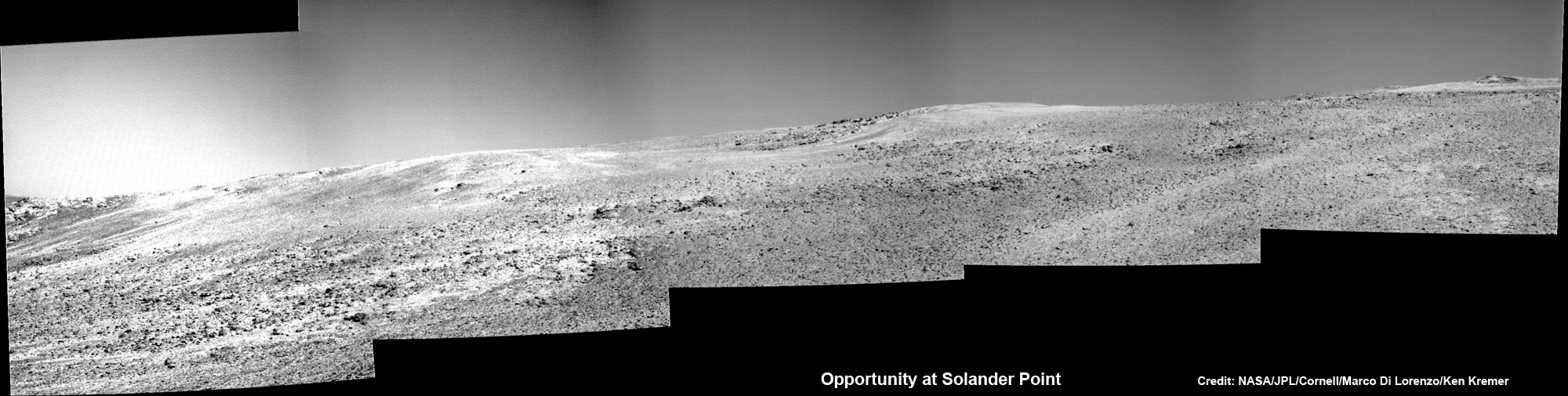
Opportunity scans Solander Point from a slope at the northern tip as she circles around the surrounding bench. This navcam camera mosaic was assembled from raw images taken on Sol 3423 (Sept. 2013). Credit: NASA/JPL/Cornell/Marco Di Lorenzo/Ken Kremer
The rover recently investigated an outcrop target called ‘Poverty Bush’. She deployed her 3 foot long (1 meter) robotic arm and collected photos with the Microscopic Imager (MI) and collected several days of spectral measurements with the Alpha Particle X-ray Spectrometer (APXS).
Thereafter she resumed driving to the west/northwest around Solander.
“On September 13, Opportunity finally landed on the bed rock of Solander Point,” wrote Larry Crumpler, a science team member from the New Mexico Museum of Natural History & Science, in his latest field report about the MER mission.
“The terrain right here is awesome,” according to Crumpler.
“There are several geologic units that are overlapping here. And Opportunity is sitting on the contact.”
“On the east side of the contact are rocks maybe a billion years older than those on the west side of the contact. This sort of age progression is what geologists look for when trying to understand the past by reading the rocks.”
“Opportunity is allowing us for the first time to do not only fundamental geographic exploration, but it is enabling on the ground geologic study of past climatic history on Mars,” notes Crumpler.
Today marks Opportunity’s 3441st Sol or Martian Day roving Mars – for what was expected to be only a 90 Sol mission.
Traverse Map for NASA’s Opportunity rover from 2004 to 2013
This map shows the entire path the rover has driven during more than 9 years and over 3431 Sols, or Martian days, since landing inside Eagle Crater on Jan 24, 2004 to current location at foothills of Solander Point at the western rim of Endeavour Crater. Rover is now ascending Solander. Opportunity discovered clay minerals at Esperance – indicative of a habitable zone. Credit: NASA/JPL/Cornell/ASU/Marco Di Lorenzo/Ken Kremer
So far she has snapped over 184,500 amazing images on the first overland expedition across the Red Planet.
Her total odometry stands at over 23.82 miles (38.34 kilometers) since touchdown on Jan. 24, 2004 at Meridiani Planum.
Meanwhile on the opposite side of Mars, Opportunity’s younger sister rover Curiosity is trekking towards gigantic Mount Sharp and just discovered water altered pebbles at the intriguing ‘Darwin’ outcrop.
And NASA is in the final stages of processing of MAVEN, the agencies next orbiter, scheduled to blast off from Cape Canaveral on Nov.18 – see my upcoming up close article.
Learn more about Curiosity, Mars rovers, MAVEN, Orion, Cygnus, Antares, LADEE and more at Ken’s upcoming presentations
Oct 3: “Curiosity, MAVEN and the Search for Life on Mars – (3-D)”, STAR Astronomy Club, Brookdale Community College & Monmouth Museum, Lincroft, NJ, 8 PM
Oct 8: NASA’s Historic LADEE Lunar & Antares/Cygnus ISS Rocket Launches from Virginia”; Princeton University, Amateur Astronomers Assoc of Princeton (AAAP), Princeton, NJ, 8 PM
NASA’s MAVEN Mars orbiter, chief scientist Prof. Bruce Jakosky of CU-Boulder and Ken Kremer of Universe Today inside the cleanroom at the Kennedy Space Center on Sept. 27, 2013. MAVEN launches to Mars on Nov. 18, 2013 from Florida. Credit: Ken Kremer/kenkremer.com
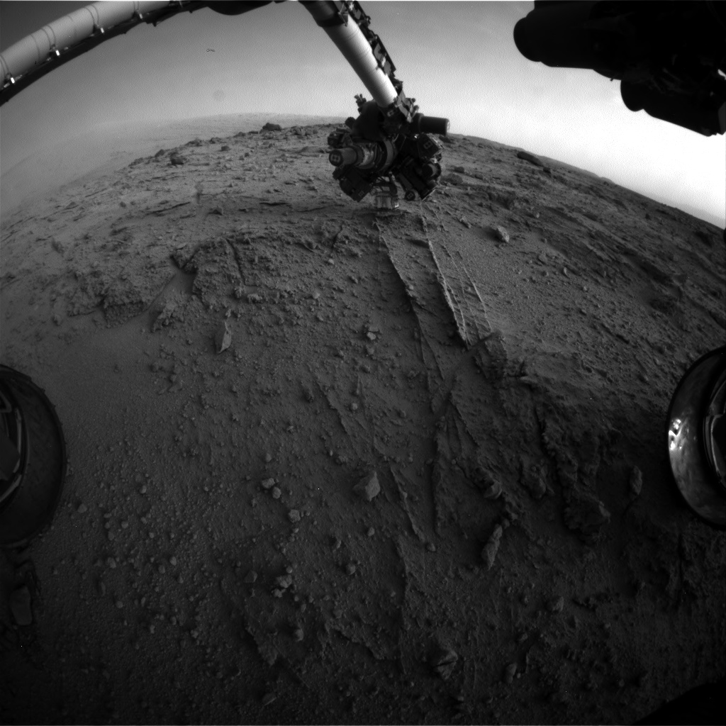
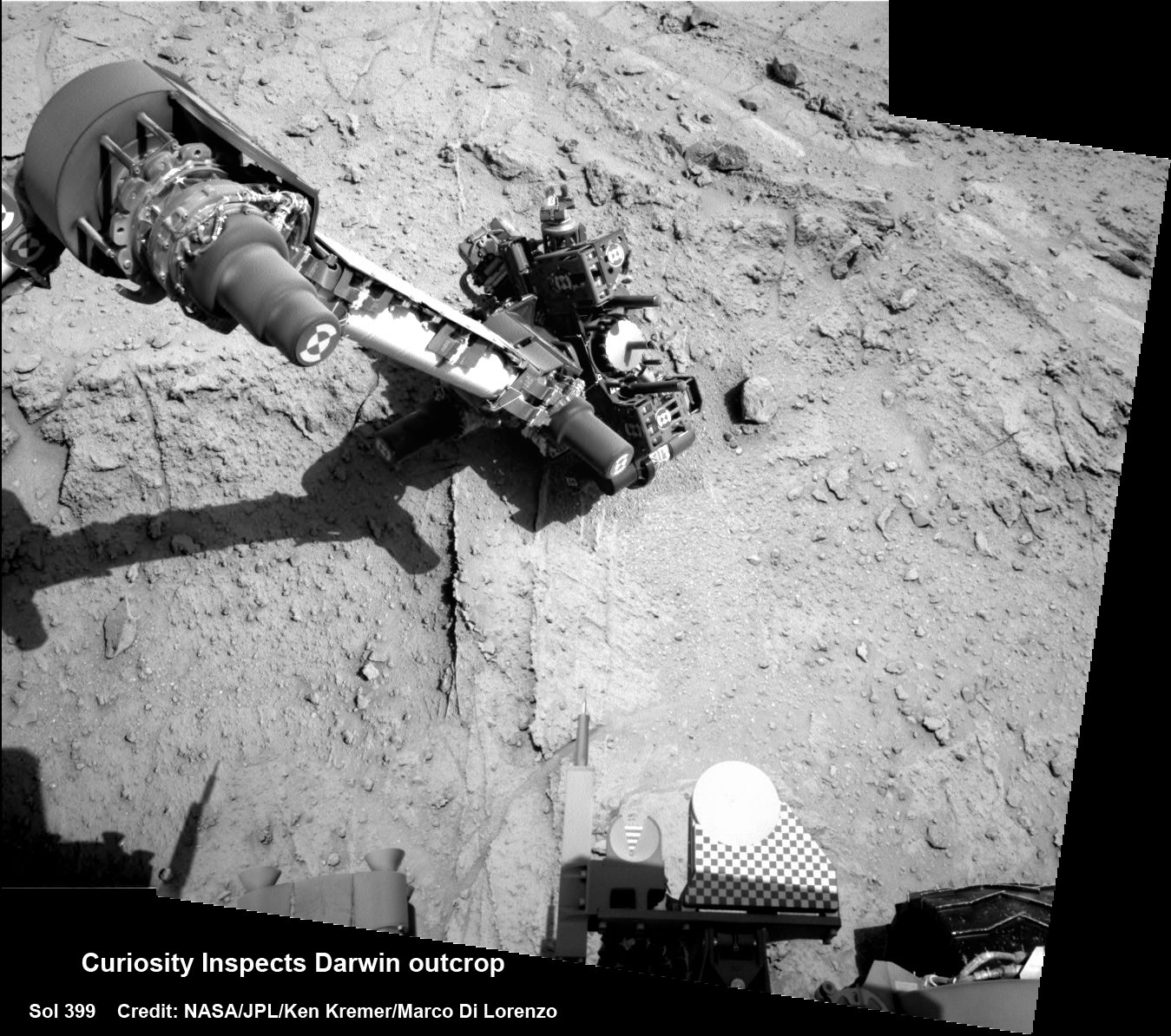
NASA's Mars rover Curiosity used a new technique, with added autonomy for the rover, in placement of the tool-bearing turret on its robotic arm during the 399th Martian day, or sol, of the mission. This image from the rover's front Hazard Avoidance Camera (Hazcam) on that sol shows the position of the turret during that process, with the Alpha Particle X-ray Spectrometer (APXS) instrument placed close to the target rock. Credit: NASA/JPL-Caltech
NASA’s Curiosity rover has discovered a new patch of pebbles formed and rounded eons ago by flowing liquid water on the Red Planet’s surface along the route she is trekking across to reach the base of Mount Sharp – the primary destination of her landmark mission.
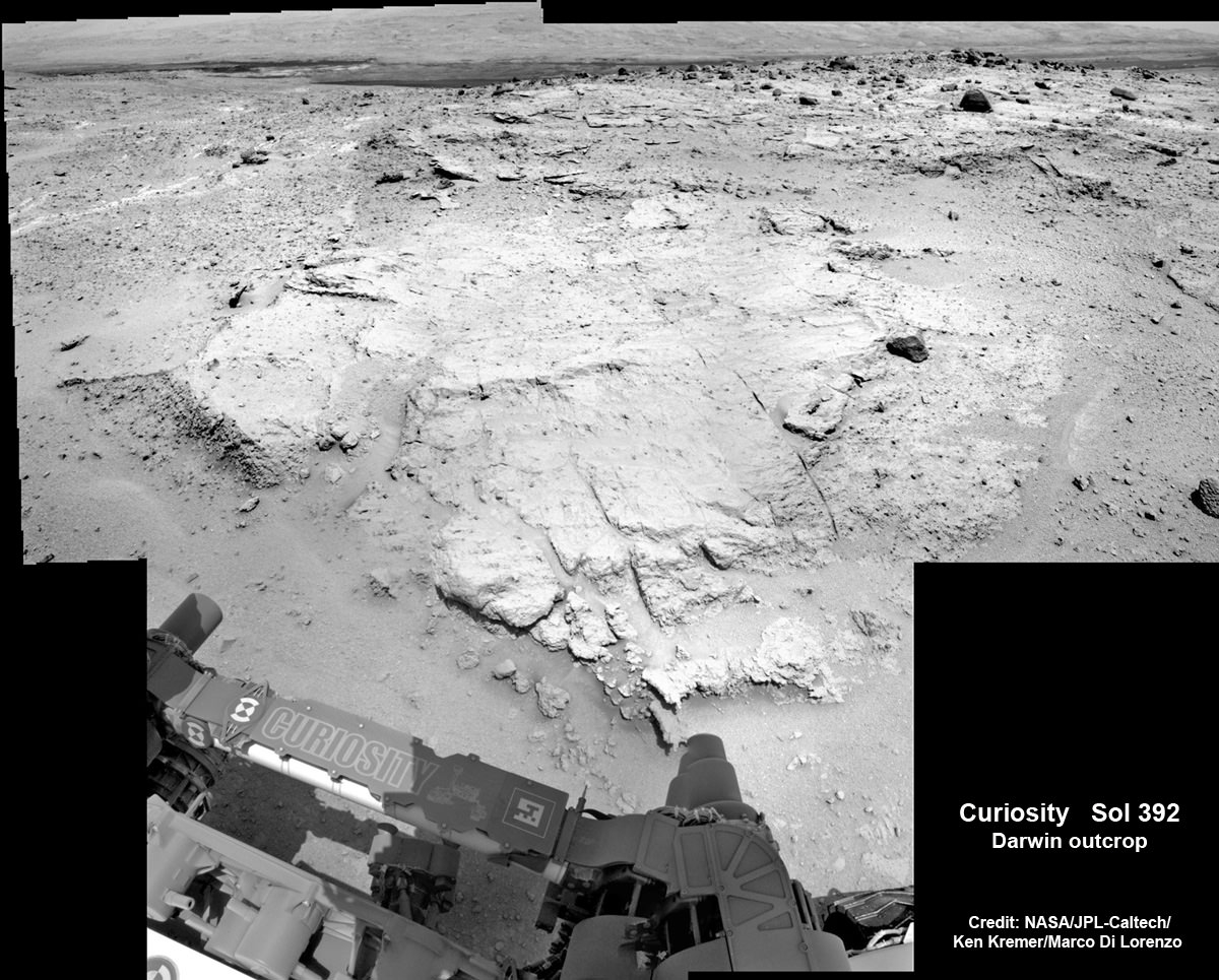
Curiosity made the new finding at a sandstone outcrop called ‘Darwin’ during a brief science stopover spot called ‘Waypoint 1’.
Before arriving at Waypoint 1, the question was- “Did life giving water once flow here on the Red Planet?
The answer now is clearly ‘Yes!’ – And it demonstrates the teams wisdom in pausing to inspect ‘Darwin’.
The discovery at Darwin is significant because it significantly broadens the area here that was altered by flowing liquid water.
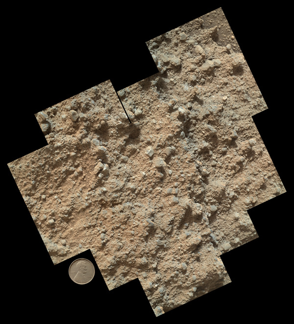
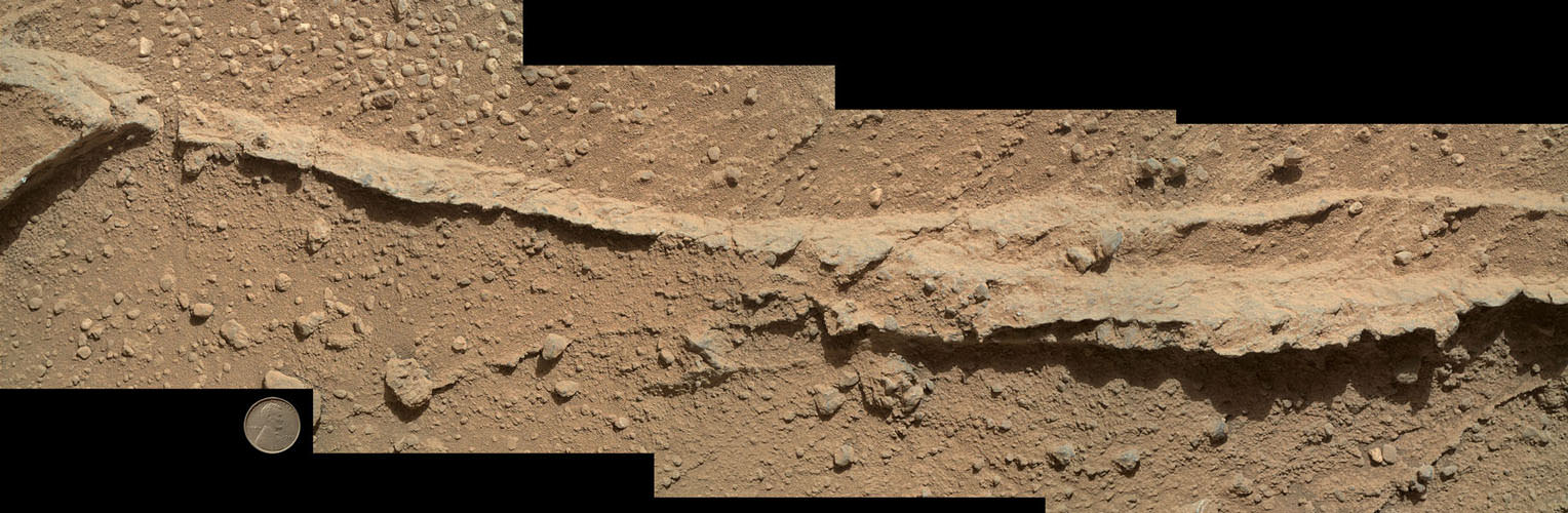
This mosaic of nine images, taken by the Mars Hand Lens Imager (MAHLI) camera on NASA’s Mars rover Curiosity, shows detailed texture in a conglomerate rock bearing small pebbles and sand-size particles. Credit: NASA/JPL-Caltech/MSSS
The presence of water is an essential prerequisite for the formation and evolution of life.
“Curiosity has arrived at Waypoint 1,” project scientist John Grotzinger, of the California Institute of Technology in Pasadena, told Universe Today at the time.
The robot pulled into ‘Waypoint 1’ on Sept. 12 (Sol 392).
“It’s a chance to study outcrops along the way,” Grotzinger told me.
This mosaic of four images taken by the Mars Hand Lens Imager (MAHLI) camera on NASA’s Mars rover Curiosity shows detailed texture in a ridge that stands higher than surrounding rock. The rock is at a location called “Darwin,” inside Gale Crater. Exposed outcrop at this location, visible in images from the High Resolution Imaging Science Experment (HiRISE) camera on NASA’s Mars Reconnaissance Orbiter, prompted Curiosity’s science team to select it as the mission’s first waypoint for several days during the mission’s long trek from the “Glenelg” area to Mount Sharp. Image Credit: NASA/JPL-Caltech/MSSS
The six wheeled rover is in the initial stages of what is sure to be an epic trek across the floor of her landing site inside the nearly 100 mile wide Gale Crater – that is dominated by humongous Mount Sharp that reaches over 3 miles (5 Kilometers) into the red Martian Sky.
“We examined pebbly sandstone deposited by water flowing over the surface, and veins or fractures in the rock,” said Dawn Sumner of University of California, Davis, a Curiosity science team member with a leadership role in planning the stop, in a NASA statement about Darwin and Waypoint 1.
“We know the veins are younger than the sandstone because they cut through it, but they appear to be filled with grains like the sandstone.”
Curiosity deploys robot arm to investigate the ‘Darwin’ rock outcrop up close at ‘Waypoint 1’ on Sept 20 (Sol 399). This photo mosaic was assembled from navcam images taken on Sept 20, 2013. Credit: NASA/JPL-Caltech/Ken Kremer/Marco Di Lorenzo
Waypoint 1 is the first of up to five waypoint stops planned along the roving route that stretches about 5.3 miles (8.6 kilometers) between the “Glenelg” area, where Curiosity worked for more than six months through the first half of 2013, and the currently planned entry point at the base of Mount Sharp.
To date, the robot has now driven nearly 20% of the way towards the base of the giant layered Martian mountain she will eventually scale in search of life’s ingredients.
“Darwin is named after a geologic formation of rocks from Antarctica,” Grotzinger informed Universe Today.
‘Waypoint 1’ was an area of intriguing outcrops that was chosen based on high resolution orbital imagery taken by NASA’s Mars Reconnaissance Orbiter (MRO) circling some 200 miles overhead.
Investigation of the conglomerate rock outcrop dubbed ‘Darwin’ was the top priority of the Waypoint 1 stop.
The finding of a cache of watery mineral veins was a big added science bonus that actually indicates a more complicated story in Mars past – to the delight of the science team.
“We want to understand the history of water in Gale Crater,” Sumner said.
“Did the water flow that deposited the pebbly sandstone at Waypoint 1 occur at about the same time as the water flow at Yellowknife Bay? If the same fluid flow produced the veins here and the veins at Yellowknife Bay, you would expect the veins to have the same composition.’
“We see that the veins are different, so we know the history is complicated. We use these observations to piece together the long-term history.”
The Rover inspected Darwin from two different positions over 4 days, or Martian Sols and conducted ‘contact science’ by deploying the robotic arm and engaging the science instrument camera and spectrometer mounted on the turret at the arms terminus.
The Alpha Particle X-ray Spectrometer (APXS) collected spectral measurements of the elemental chemistry and the Mars Hand Lens Imager is a camera showing the outcrops textures, shapes and colors.
Curiosity investigates the ‘Darwin’ rock outcrop up close after arriving for a short stay at ‘Waypoint 1’ on Sept 12 (Sol 392). This photo mosaic was assembled from navcam images taken on Sept 12, 2013. Credit: NASA/JPL-Caltech/Ken Kremer/Marco Di Lorenzo
What’s the origin of Darwin’s name?
“Darwin comes from a list of 100 names the team put together to designate rocks in the Mawson Quadrangle – Mawson is the name of a geologist who studied Antarctic geology,” Grotzinger told me.
“We’ll stay just a couple of sols at Waypoint 1 and then we hit the road again,” Grotzinger told me.
And indeed on Sept. 22, the rover departed Darwin and Waypoint 1 on a westward heading to resume the many months long journey to Mount Sharp.
Learn more about Curiosity, Mars rovers, MAVEN, Orion, Cygnus, Antares, LADEE and more at Ken’s upcoming presentations
Oct 3: “Curiosity, MAVEN and the Search for Life on Mars – (3-D)”, STAR Astronomy Club, Brookdale Community College & Monmouth Museum, Lincroft, NJ, 8 PM
Oct 8: NASA’s Historic LADEE Lunar & Antares/Cygnus ISS Rocket Launches from Virginia”; Princeton University, Amateur Astronomers Assoc of Princeton (AAAP), Princeton, NJ, 8 PM
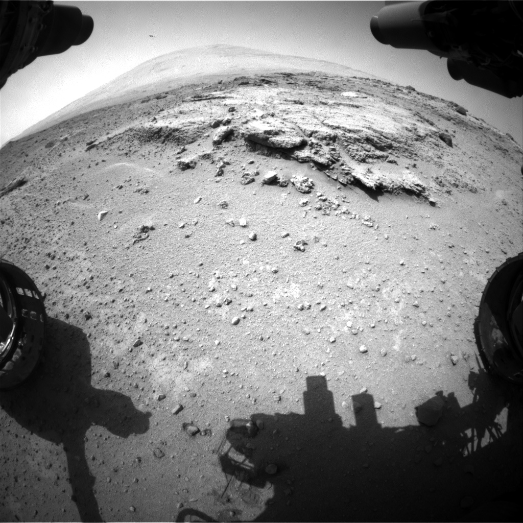
Curiosity’s views a rock outcrop after arriving for a short stay at ‘Waypoint 1’- dramatically back dropped by her primary destination, Mount Sharp. Front hazcam camera image from Sol 393 (Sept 13, 2013). Credit: NASA/JPL-Caltech
Curiosity’s views a rock outcrop at ‘Darwin’ after arriving for a short stay at ‘Waypoint 1’ on Sept 12 (Sol 392) – dramatically back dropped by her primary destination, Mount Sharp. Front hazcam camera image from Sol 393 (Sept 13, 2013). Credit: NASA/JPL-Caltech
Story updated – see close up mosaic views of Darwin outcrop below[/caption]
NASA’s Curiosity Mars rover has just rolled into an intriguing site called ‘Darwin’ at ‘Waypoint 1’- having quickly picked up the driving pace since embarking at last on her epic trek to mysterious Mount Sharp more than two months ago. Did life giving water once flow here on the Red Planet?
Because the long journey to Mount Sharp – the robots primary destination – was certain to last nearly a year, the science team carefully choose a few stopping points for study along the way to help characterize the local terrain. And Curiosity has just pulled into the first of these so called ‘Waypoints’ on Sept 12 (Sol 392), the lead scientist confirmed to Universe Today.
“Curiosity has arrived at Waypoint 1,” project scientist John Grotzinger, of the California Institute of Technology in Pasadena, told Universe Today.
“Darwin is named after a geologic formation of rocks from Antarctica.”
She has now driven nearly 20% of the way towards the base of the giant layered Martian mountain she will eventually scale in search of life’s ingredients.
Altogether, the team selected five ‘Waypoints’ to investigate for a few days each as Curiosity travels in a southwestward direction on the road from the first major science destination in the ‘Glenelg’ area to the foothills of Mount Sharp, says Grotzinger.
“We’ll stay just a couple of sols at Waypoint 1 and then we hit the road again,” Grotzinger told me.
Curiosity’s Progress on Rapid Transit Route from ‘Glenelg’ (start at top) to Mount Sharp entry point (bottom). Triangles indicate geologic ‘Waypoint’ stopping points along the way. Curiosity arrived at Waypoint 1 on Sol 392 (Sept 12, 2013). Credit: NASA
‘Waypoint 1’ is an area of intriguing outcrops that was chosen based on high resolution orbital imagery taken by NASA’s Mars Reconnaissance Orbiter (MRO) circling some 200 miles overhead. See route map herein.
In fact the team is rather excited about ‘Waypoint 1’ that’s dominated by the tantalizing rocky outcrop discovered there nicknamed ‘Darwin’.
Although Curiosity will only stay a short time at each of the stops, the measurements collected at each ‘Waypoint’ will provide essential clues to the overall geologic and environmental history of the six wheeled rover’s touchdown zone.
“Waypoint 1 was chosen to help break up the drive,” Grotzinger explained to Universe Today.
“It’s a chance to study outcrops along the way.”
The images from MRO are invaluable in aiding the rover handlers planning activities, selecting Curiosity’s driving route and targeting of the most fruitful science forays during the long trek to Mount Sharp – besides being absolutely crucial for the selection of Gale Crater as the robots landing site in August 2012.
The ‘Darwin’ outcrop may provide more data on the flow of liquid water across the crater floor.
Evolving Excitement Over ‘Darwin’ Rock Outcrop at ‘Waypoint 1’. For at least a couple of days, the science team of NASA’s Mars rover Curiosity is focused on a full-bore science campaign at a tantalizing, rocky site informally called “Darwin.” This view of Darwin was taken with the Mast Camera (Mastcam) on Sol 390 (Sept. 10, 2013). Credit: NASA/JPL-Caltech/Malin Space Science Systems
The scientists goal is to compare the floor of Gale Crater to the sedimentary layers of 3 mile high (5 kilometer high) Mount Sharp.
Waypoint 1 is just over 1 mile along the approximately 5.3-mile (8.6-kilometer) route from ‘Glenelg’ to the entry point at the base of Mount Sharp.
Curiosity spent over six months investigating the ‘Yellowknife Bay’ area inside Glenelg before departing on July 4, 2013.
What’s the origin of Darwin’s name?
“Darwin comes from a list of 100 names the team put together to designate rocks in the Mawson Quadrangle – Mawson is the name of a geologist who studied Antarctic geology,” Grotzinger told me.
“Recently we left the Yellowknife Quadrangle, so instead of naming rocks after geological formations in Canada’s north, we now turn to formation names of rocks from Antarctica, and Darwin is one of them.
“That will be the theme until we cross into the next quad,” Grotzinger explained.
Curiosity investigates the ‘Darwin’ rock outcrop up close after arriving for a short stay at ‘Waypoint 1’ on Sept 12 (Sol 392). This photo mosaic was assembled from navcam images taken on Sept 12, 2013. Credit: NASA/JPL-Caltech/Ken Kremer/Marco Di Lorenzo
Inside Yellowknife Bay, Curiosity conducted the historic first interplanetary drilling into Red Planet rocks and subsequent sample analysis with her duo of state of the art chemistry labs – SAM and CheMin.
At Yellowknife Bay, the 1 ton robot discovered a habitable environment containing the chemical ingredients that could sustain Martian microbes- thereby already accomplishing the primary goal of NASA’s flagship mission to Mars.
“We want to know how the rocks at Yellowknife Bay are related to what we’ll see at Mount Sharp,” Grotzinger elaborated in a NASA statement. “That’s what we intend to get from the waypoints between them. We’ll use them to stitch together a timeline — which layers are older, which are younger.”
On Sept. 5, Curiosity set a new one-day distance driving record for the longest drive yet by advancing 464 feet (141.5 meters) on her 13th month on the Red Planet.
As Curiosity neared Waypoint 1 she stopped at a rise called ‘Panorama Point’ on Sept. 7, spotted an outcrop of light toned streaks informally dubbed ‘Darwin and used her MastCam telephoto camera to collect high resolution imagery.
Curiosity will use her cameras, spectrometers and robotic arm for contact science and a “full bore science campaign” involving in-depth mineral and chemical composition analysis of Darwin and Waypoint 1 for the next few Sols, or Martian days, before resuming the trek to Mount Sharp that dominates the center of Gale Crater.
Curiosity Spies Mount Sharp – her primary destination. Curiosity will ascend mysterious Mount Sharp and investigate the sedimentary layers searching for clues to the history and habitability o the Red Planet of billions of years. This mosaic was assembled from Mastcam camera images taken on Sol 352 (Aug 2, 2013). Credit: NASA/JPL-Caltech/MSSS/ Marco Di Lorenzo/Ken Kremer
She will not conduct any drilling here or at the other waypoints, several team members have told me, unless there is some truly remarkable ‘Mars-shattering’ discovery.
Why is Curiosity now able to drive longer than ever before?
“We have put some new software – called autonav, or autonomous navigation – on the vehicle right after the conjunction period back in March 2013,” Jim Erickson, Curiosity Project Manager of NASA’s Jet Propulsion Laboratory (JPL), told Universe Today.
“This will increase our ability to drive. But how much it helps really depends on the terrain.”
And so far the terrain has cooperated.
“We are on a general heading of southwest to Mount Sharp,” said Erickson. See the NASA JPL route map.
“We have been going through various options of different planned routes.”
As of today (Sol 394), Curiosity remains healthy, has traveled 2.9 kilometers and snapped over 82,000 images.
If all goes well Curiosity could reach the entry point to Mount Sharp sometime during Spring 2014, at her current driving pace.
Learn more about Curiosity, Mars rovers,LADEE, Cygnus, Antares, MAVEN, Orion and more at Ken’s upcoming presentations
Sep 17/18: LADEE Lunar & Antares/Cygnus ISS Rocket Launches from Virginia”; Rodeway Inn, Chincoteague, VA
Oct 3: “Curiosity, MAVEN and the Search for Life on Mars – (3-D)”, STAR Astronomy Club, Brookdale Community College & Monmouth Museum, Lincroft, NJ, 8 PM
Oct 8: LADEE Lunar & Antares/Cygnus ISS Rocket Launches from Virginia”; Princeton University, Amateur Astronomers Assoc of Princeton (AAAP), Princeton, NJ, 8 PM
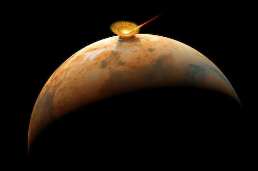
Are Earthlings really Martians ? Did life arise on Mars first and then journey on meteors to our planet and populate Earth billions of years ago? Earth and Mars are compared in size as they look today.
Are Earthlings really Martians ?
Did life arise on Mars first and then journey on rocks to our planet and populate Earth billions of years ago? Earth and Mars are compared in size as they look today. NASA’s upcoming MAVEN Mars orbiter is aimed at answering key questions related to the habitability of Mars, its ancient atmosphere and where did all the water go. Story updated[/caption]
That’s the controversial theory proposed today (Aug. 29) by respected American chemist Professor Steven Benner during a presentation at the annual Goldschmidt Conference of geochemists being held in Florence, Italy. It’s based on new evidence uncovered by his research team and is sure to spark heated debate on the origin of life question.
Benner said the new scientific evidence “supports the long-debated theory that life on Earth may have started on Mars,” in a statement. Universe Today contacted Benner for further details and enlightenment.
“We have chemistry that (at least at the level of hypothesis) makes RNA prebiotically,” Benner told Universe Today. “AND IF you think that life began with RNA, THEN you place life’s origins on Mars.” Benner said he has experimental data as well.
First- How did ancient Mars life, if it ever even existed, reach Earth?
On rocks violently flung up from the Red Planet’s surface during mammoth collisions with asteroids or comets that then traveled millions of miles (kilometers) across interplanetary space to Earth – melting, heating and exploding violently before the remnants crashed into the solid or liquid surface.
An asteroid impacts ancient Mars and send rocks hurtling to space – some reach Earth. Did they transport Mars life to Earth? Or minerals that could catalyze the origin of life on Earth?
“The evidence seems to be building that we are actually all Martians; that life started on Mars and came to Earth on a rock,” says Benner, of The Westheimer Institute of Science and Technology in Florida. That theory is generally known as panspermia.
To date, about 120 Martian meteorites have been discovered on Earth.
And Benner explained that one needs to distinguish between habitability and the origin of life.
“The distinction is being made between habitability (where can life live) and origins (where might life have originated).”
NASA’s new Curiosity Mars rover was expressly dispatched to search for environmental conditions favorable to life and has already discovered a habitable zone on the Red Planet’s surface rocks barely half a year after touchdown inside Gale Crater.
Furthermore, NASA’s next Mars orbiter- named MAVEN – launches later this year and seeks to determine when Mars lost its atmosphere and water- key questions in the Origin of Life debate.
Curiosity accomplished Historic 1st drilling into Martian rock at John Klein outcrop on Feb 8, 2013 (Sol 182) and discovered a habitable zone, shown in this context mosaic view of the Yellowknife Bay basin taken on Jan. 26 (Sol 169). The robotic arm is pressing down on the surface at John Klein outcrop of veined hydrated minerals – dramatically back dropped with her ultimate destination; Mount Sharp. Credit: NASA/JPL-Caltech/Ken Kremer-kenkremer.com/Marco Di Lorenzo
Of course the proposed chemistry leading to life is exceedingly complex and life has never been created from non-life in the lab.
The key new points here are that Benner believes the origin of life involves “deserts” and oxidized forms of the elements Boron (B) and Molybdenum (Mo), namely “borate and molybdate,” Benner told me.
“Life originated some 4 billion years ago ± 0.5 billon,” Benner stated.
He says that there are two paradoxes which make it difficult for scientists to understand how life could have started on Earth – involving organic tars and water.
Life as we know it is based on organic molecules, the chemistry of carbon and its compounds.
But just discovering the presence of organic compounds is not the equivalent of finding life. Nor is it sufficient for the creation of life.
And simply mixing organic compounds aimlessly in the lab and heating them leads to globs of useless tars, as every organic chemist and lab student knows.
Benner dubs that the ‘tar paradox’.
Although Curiosity has not yet discovered organic molecules on Mars, she is now speeding towards a towering 3 mile (5 km) high Martian mountain known as Mount Sharp.
Curiosity Spies Mount Sharp – her primary destination
Curiosity will ascend mysterious Mount Sharp and investigate the sedimentary layers searching for clues to the history and habitability of the Red Planet over billions of years. This mosaic was assembled from over 3 dozen Mastcam camera images taken on Sol 352 (Aug 2, 2013. Credit: NASA/JPL-Caltech/MSSS/ Marco Di Lorenzo/Ken Kremer-kenkremer.com
Upon arrival sometime next spring or summer, scientists will target the state of the art robot to investigate the lower sedimentary layers of Mount Sharp in search of clues to habitability and preserved organics that could shed light on the origin of life question and the presence of borates and molybdates.
It’s clear that many different catalysts were required for the origin of life. How much and their identity is a big part of Benner’s research focus.
“Certain elements seem able to control the propensity of organic materials to turn into tar, particularly boron and molybdenum, so we believe that minerals containing both were fundamental to life first starting,” says Benner in a statement. “Analysis of a Martian meteorite recently showed that there was boron on Mars; we now believe that the oxidized form of molybdenum was there too.”
The second paradox relates to water. He says that there was too much water covering the early Earth’s surface, thereby causing a struggle for life to survive. Not exactly the conventional wisdom.
“Not only would this have prevented sufficient concentrations of boron forming – it’s currently only found in very dry places like Death Valley – but water is corrosive to RNA, which scientists believe was the first genetic molecule to appear. Although there was water on Mars, it covered much smaller areas than on early Earth.”
Parts of ancient Mars were covered by oceans, lakes and streams of liquid water in this artists concept, unlike the arid and bone dry Martian surface of today. Subsurface water ice is what remains of Martian water.
I asked Benner to add some context on the beneficial effects of deserts and oxidized boron and molybdenum.
“We have chemistry that (at least at the level of hypothesis) makes RNA prebiotically,” Benner explained to Universe Today.
“We require mineral species like borate (to capture organic species before they devolve to tar), molybdate (to arrange that material to give ribose), and deserts (to dry things out, to avoid the water problem).”
“Various geologists will not let us have these [borates and molybdates] on early Earth, but they will let us have them on Mars.”
“So IF you believe what the geologists are telling you about the structure of early Earth, AND you think that you need our chemistry to get RNA, AND IF you think that life began with RNA, THEN you place life’s origins on Mars,” Benner elaborated.
“The assembly of RNA building blocks is thermodynamically disfavored in water. We want a desert to get rid of the water intermittently.”
I asked Benner whether his lab has run experiments in support of his hypothesis and how much borate and molybdate are required.
“Yes, we have run many lab experiments. The borate is stoichiometric [meaning roughly equivalent to organics on a molar basis]; The molybdate is catalytic,” Benner responded.
“And borate has now been found in meteorites from Mars, that was reported about three months ago.
At his talk, Benner outlined some of the chemical reactions involved.
Although some scientists have invoked water, minerals and organics brought to ancient Earth by comets as a potential pathway to the origin of life, Benner thinks differently about the role of comets.
“Not comets, because comets do not have deserts, borate and molybdate,” Benner told Universe Today.
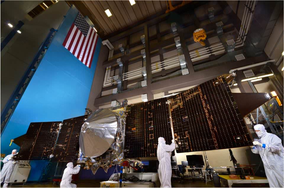
MAVEN is NASA’s next Mars orbiter and seeks to determine when Mars lost its atmosphere and water- key questions in the Origin of Life debate. MAVEN is slated to blastoff for Mars on Nov. 18, 2013. It is shown here with solar panels deployed as part of environmental testing procedures at Lockheed Martin Space Systems in Waterton, Colorado, before shipment to Florida in early August. Credit: Lockheed Martin
Benner has developed a logic tree outlining his proposal that life on Earth may have started on Mars.
“It explains how you get to the conclusion that life originated on Mars. As you can see from the tree, you can escape that conclusion by diverging from the logic path.”
Finally, Benner is not one who blindly accepts controversial proposals himself.
He was an early skeptic of the claims concerning arsenic based life announced a few years back at a NASA sponsored press conference, and also of the claims of Mars life discovered in the famous Mars meteorite known as ALH 84001.
“I am afraid that what we thought were fossils in ALH 84001 are not.”
The debate on whether Earthlings are really Martians will continue as science research progresses and until definitive proof is discovered and accepted by a consensus of the science community of Earthlings – whatever our origin.
On Nov. 18, NASA will launch its next mission to Mars – the MAVEN orbiter. Its aimed at studying the upper Martian atmosphere for the first time.
“MAVENS’s goal is determining the composition of the ancient Martian atmosphere and when it was lost, where did all the water go and how and when was it lost,” said Bruce Jakosky to Universe Today at a MAVEN conference at the University of Colorado- Boulder. Jakosky, of CU-Boulder, is the MAVEN Principal Investigator.
MAVEN will shed light on the habitability of Mars billions of years ago and provide insight on the origin of life questions and chemistry raised by Benner and others.
…………….
Learn more about Mars, the Origin of Life, LADEE, Cygnus, Antares, MAVEN, Orion, Mars rovers and more at Ken’s upcoming presentations
Sep 5/6/16/17: “LADEE Lunar & Antares/Cygnus ISS Rocket Launches from Virginia”; Rodeway Inn, Chincoteague, VA, 8 PM
Oct 3: “Curiosity, MAVEN and the Search for Life on Mars – (3-D)”, STAR Astronomy Club, Brookdale Community College & Monmouth Museum, Lincroft, NJ, 8 PM
Oct 9: “LADEE Lunar & Antares/Cygnus ISS Rocket Launches from Virginia”; Princeton University, Amateur Astronomers Assoc of Princeton (AAAP), Princeton, NJ, 8 PM
Curiosity Spies Mount Sharp - her primary destination. Curiosity will ascend mysterious Mount Sharp and investigate the sedimentary layers searching for clues to the history and habitability o the Red Planet of billions of years. This mosaic was assembled from Mastcam camera images taken on Sol 352 (Aug 2, 2013. Credit: NASA/JPL-Caltech/MSSS/ Marco Di Lorenzo/Ken Kremer
Curiosity Spies Mount Sharp – her primary destination. Curiosity will ascend mysterious Mount Sharp and investigate the sedimentary layers searching for clues to the history and habitability of the Red Planet over billions of years. But first she must safely trespass through the treacherous dark dunes fields. This mosaic was assembled from over 2 dozen Mastcam camera images taken on Sol 352 (Aug 2, 2013). Credit: NASA/JPL-Caltech/MSSS/ Marco Di Lorenzo/Ken Kremer
See the full mosaic below [/caption]
It’s never a dull moment for NASA’s Curiosity rover at T Plus 1 Year since touchdown on the Red Planet and T Minus 1 year to arriving at her primary target, the huge mountain overwhelming the center of the landing site inside Gale Crater.
Curiosity is literally and figuratively zooming in on stunningly beautiful and mysterious Mount Sharp (see our new mosaics above/below), her ultimate destination, while conducting ‘Science on the Go’ with her duo of chemistry labs – SAM and CheMin – and 8 other science instruments as she passes the 2 kilometer driving milestone today; Aug 20 !
“We are holding samples for drops to ChemMin and SAM when the science team is ready for it,” Jim Erickson, Curiosity Project Manager of NASA’s Jet Propulsion Laboratory (JPL), told Universe Today in an exclusive interview.
“Curiosity has landed in an ancient river or lake bed on Mars,” Jim Green, Director of NASA’s Planetary Science Division, told Universe Today.
So, those samples were altered by liquid Martian water – a prerequisite for life.
Curiosity Spies Mount Sharp – her primary destination. Curiosity will ascend mysterious Mount Sharp and investigate the sedimentary layers searching for clues to the history and habitability of the Red Planet over billions of years. But first she must safely trespass through the treacherous dark dunes fields. This mosaic was assembled from over 3 dozen Mastcam camera images taken on Sol 352 (Aug 2, 2013.
Credit: NASA/JPL-Caltech/MSSS/ Marco Di Lorenzo/Ken Kremer-kenkremer.com
In fact the car sized rover has saved samples from both the ‘John Klein’ and ‘Cumberland’ drill sites collected previously in the ‘Yellowknife Bay’ area for analysis by the miniaturized labs in the rovers belly -when the time is right.
“Curiosity has stored a Cumberland sample and still has a John Klein sample on board for future use,” Erickson explained.
And that time has now arrived!
“We have put a sample from the Cumberland drill hole into SAM for more isotopic measurements,” reported science team member John Bridges in a blog update on Sol 363, Aug. 14, 2013.
“The sample had been cached within the robotic arm’s turret.”
Curiosity is multitasking – conducting increasingly frequent traverses across the relatively smooth floor of Gale Crater while running research experiments for her science handlers back here on Earth.
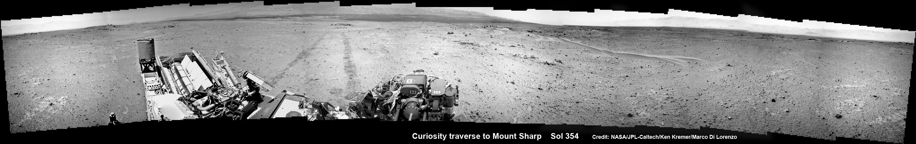
NASA’s Curiosity rover make tracks to Mount Sharp (at left) across the floor of Gale Crater. The rover paused to image the windblown ripple at right, below the hazy crater rim. The wheel tracks are about eight feet apart. This panoramic mosaic was assembled from a dozen navcam camera images taken on Sol 354 (Aug 4, 2013). Credit: NASA/JPL-Caltech/Ken Kremer/Marco Di Lorenzo
She’s captured stunning new views of Mount Sharp – rising 5 km (3 miles) high into the sky – and movies of Mars tiny pair of transiting moons while ingesting new portions of the drilled rock samples acquired earlier this year.
Here’s our video compilation of Phobos and Deimos transiting on Aug 1, 2013
Video caption: Transit of Phobos in front of Deimos, taken by MSL right MastCam imager on Sol 351 around 3:12 AM local time (Aug 1, 2013, 8:42 UTC); 16 original frames + 14 interpolated (5x speed-up). Credit: NASA/JPL-Caltech/MSSS/ Marco Di Lorenzo/Ken Kremer
The sample analysis is still in progress.
“The SAM data have not all been received yet,” wrote science team member Ken Herkenhoff in a blog update.
Earlier analysis of sample portions from both ‘John Klein’ and ‘Cumberland’ revealed that the Yellowknife Bay area on Mars possesses the key mineral ingredients proving that Red Planet was once habitable and could have sustained simple microbial life forms.
The scientists are seeking further evidence and have yet to detect organic molecules – which are the building blocks of life as we know it.
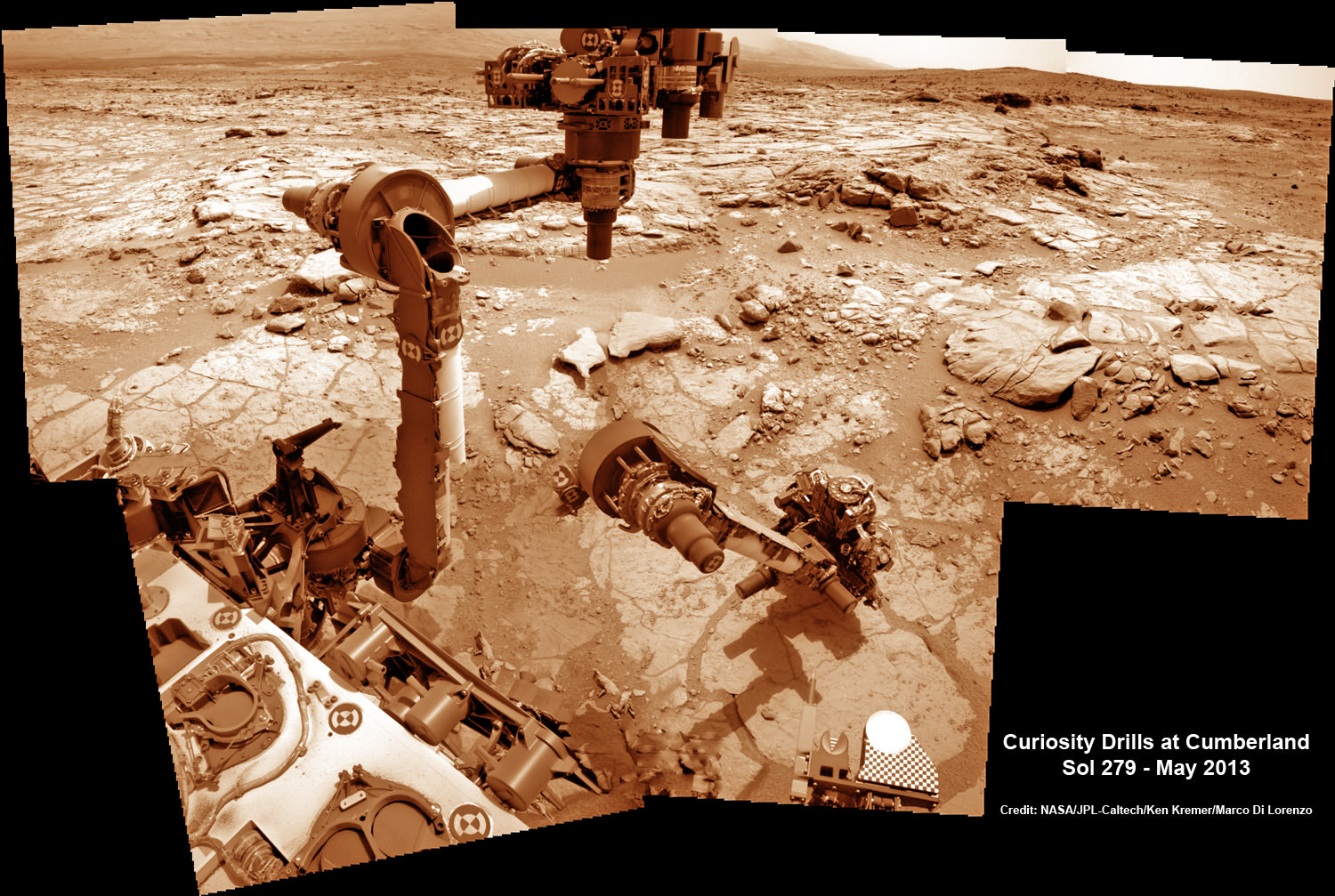
This time lapse mosaic shows Curiosity maneuvering her robotic arm to drill into her 2nd martian rock target named “Cumberland” to collect powdery Martian material on May 19, 2013 (Sol 279) for analysis by her onboard chemistry labs; SAM & Chemin- see 3 inlet ports lower left. The photomosaic was stitched from raw images captured by the navcam cameras on May 14 & May 19 (Sols 274 & 279). Credit: NASA/JPL-Caltech/Ken Kremer/Marco Di Lorenzo
Yellowknife Bay resembles a dried out river bed where liquid water once flowed eons ago when the Red Planet was far warmer and wetter than today.
As the 1 ton robot ascends Mount Sharp, she will examine sedimentary layers layed down on ancient Mars over hundreds of millions and perhaps billions of years of past history and habitability.
And just as the rover was celebrating 1 year on Mars on Aug 5/6, she found an intriguing sand dune on Sol 354. See our mosaic
“The rover paused to take images of its tracks after crossing a windblown ripple,” Herkenhoff reported.
As the six wheeled rover approaches Mount Sharp over the next year, she will eventually encounter increasing treacherous dunes that she must cross before beginning her mountain climbing foray.
As of today, Sol 369 (Aug. 20) Curiosity has broken through the 2 kilometer driving mark with a new 70 meter drive, snapped over 75,000 images and fired over 75,000 laser shots.
Mount Sharp is about 8 kilometers (5 miles) distant as the Martian crow flies.
How long will the journey to Mount Sharp require?
“Perhaps about a year,” Erickson told me. “We are trying to make that significantly faster by bringing autonav [autonomous navigation software] online.”
“That will help. But how much it helps really depends on the terrain.”
So far so good.
Meanwhile NASA’s next Mars orbiter called MAVEN (for Mars Atmosphere and Volatile Evolution), recently arrived at the Kennedy Space Center after a cross country flight.
Kennedy technicians are completing assembly and check out preparations for MAVEN’s blastoff to the Red Planet on Nov. 18 from Florida atop an Atlas V rocket similar to the one that launched Curiosity nearly 2 years ago.
And I’ll be at Kennedy to report up close on MAVEN’s launch.