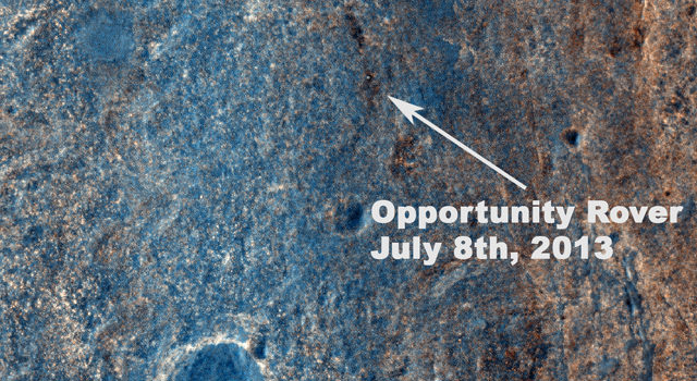
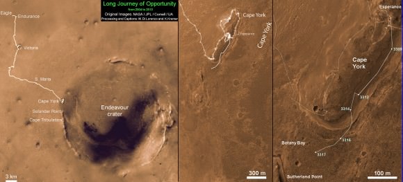
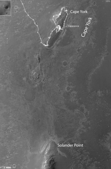
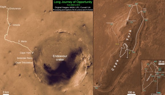
This image taken by the High Resolution Imaging Science Experiment (HiRISE) camera on NASA's Mars Reconnaissance Orbiter on July 8, 2013, captures Opportunity traversing south (at the end of the white arrow) to new science targets and a winter haven at "Solander Point," another portion of the Endeavour rim. The relatively level ground between Cape York and Solander Point is called "Botany Bay." The image was taken 10 years after Opportunity was launched from Florida on July 7, 2013, EDT and PDT (July 8, Universal Time). Image credit: NASA/JPL-Caltech/Univ. of Arizona.
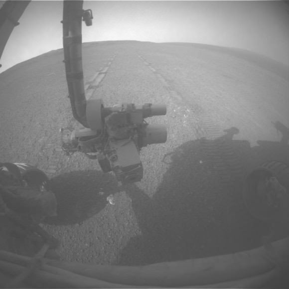
Ten years to the day after the Opportunity rover launched to Mars, the HiRISE camera on the Mars Reconnaissance Orbiter snapped this image of the rover, still toiling away on the surface of Mars. The white dot in the image is Oppy, as the rover was crossing the level ground called “Botany Bay” on its way to a rise called “Solander Point.” We’re looking into whether there’s a way to determine if the rover was actually moving at the time the image was taken.
This, of course, is not the first time HiRISE has found the various rovers on Mars’ surface. Images from orbit help rover drivers find safe routes, as well as helping to identify enticing science targets for future investigation.
“The Opportunity team particularly appreciates the color image of Solander Point because it provides substantially more information on the terrains and traverse that Opportunity will be conducting over the next phase of our exploration of the rim of Endeavour crater,” said Mars Science Laboratory Project Scientist Matt Golombek, from JPL.
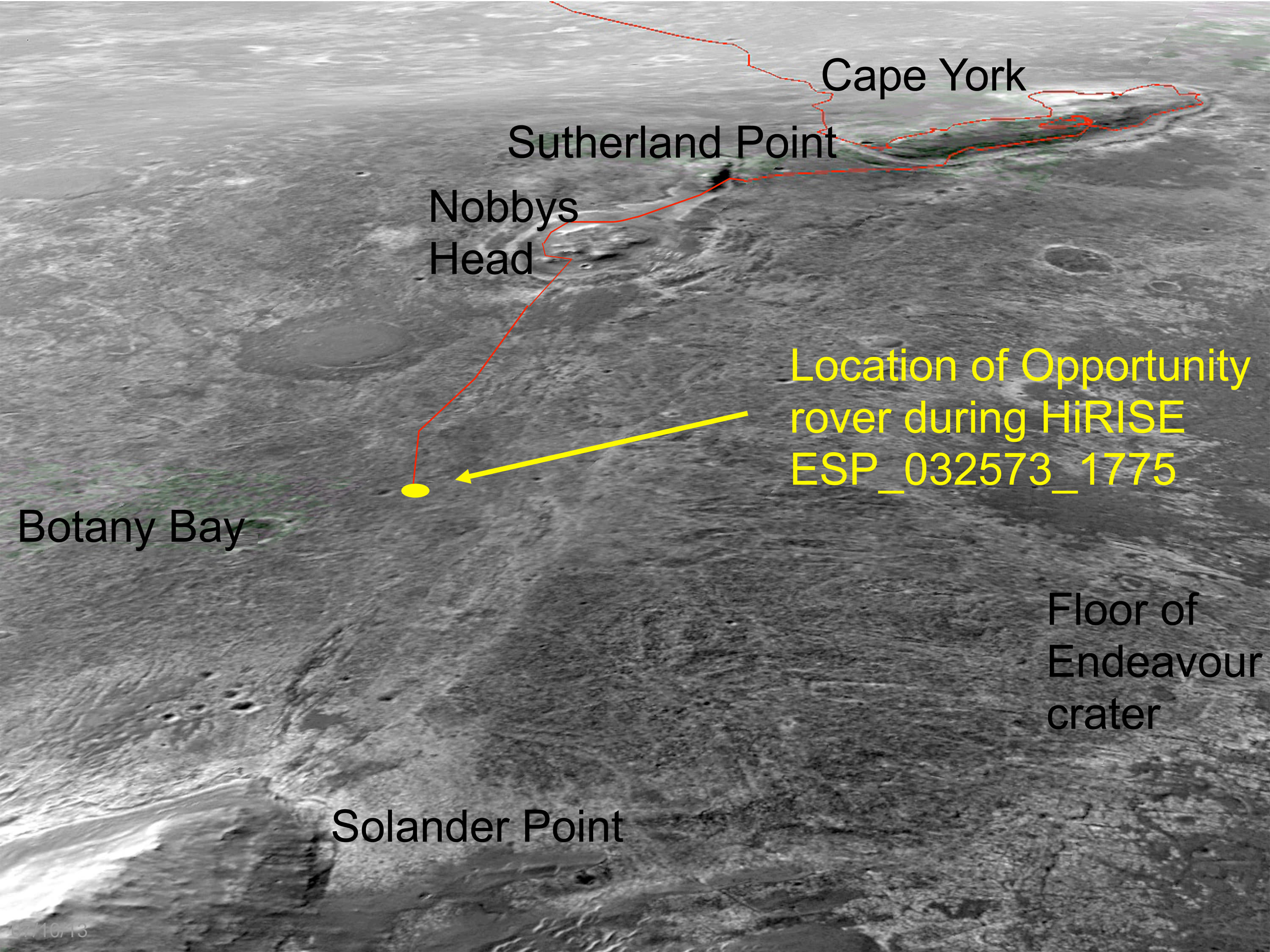
an oblique, northward-looking view based on stereo orbital imaging, shows the location of Opportunity on its journey from Cape York to Solander Point when HiRISE took the new color image. Endeavour Crater is about 14 miles (22 kilometers) in diameter. The distance from Cape York to Solander Point is about 1.2 miles (2 kilometers). The red line indicates the path the rover has driven. Credit: NASA/JPL-Caltech/Univ. of Arizona.
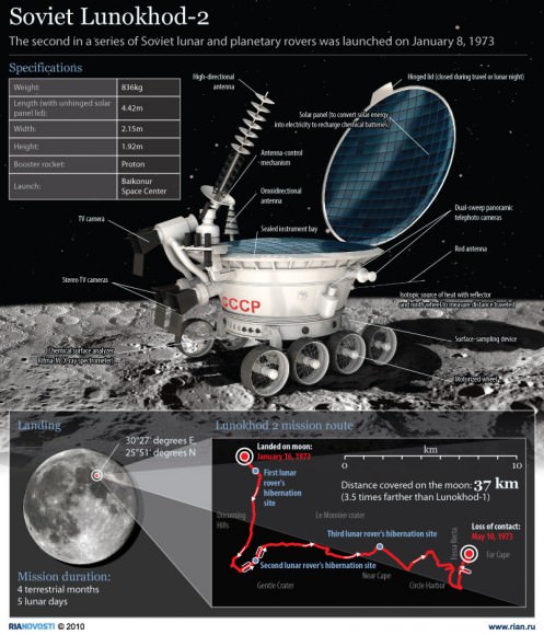
Opportunity currently holds the US space program’s all-time record for distance traversed on another planetary body at greater than 36 kilometers or 22 miles. The Lunar Reconnaissance Orbiter team recently confirmed that the Lunokhod 2 rover traveled 42 km (26 miles) on the Moon.
Opportunity was launched from on July 7, 2003, PDT and EDT (July 8, Universal Time). Opportunity has been on the western rim of 20-kilometer-diameter Endeavour Crater in Meridiani Planum for about two years investigating the 3 to 4 billion-year-old sedimentary layers of Cape York. Now the rover is traversing south to new science targets and a winter haven at Solander Point.
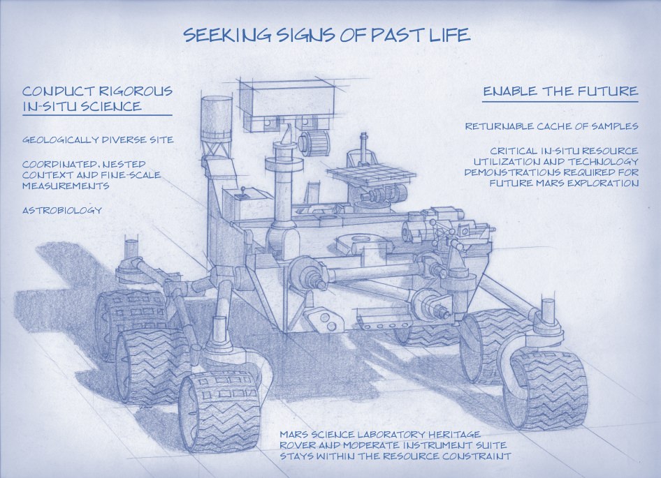
Artist's Concept of NASA’s Mars 2020 Rover envisions a basic structure that capitalizes on re-using the design and engineering work done for the NASA rover Curiosity, which landed on Mars in 2012, but with new science instruments for accomplishing different science objectives with the 2020 mission. Credit: NASA/JPL-Caltech
NASA’s next Mars rover set for liftoff in 2020 should focus on three primary objectives; seeking signs of past life, collecting a cache of carefully chosen samples for eventual return to Earth and developing technologies that will help enable future human missions to the Red Planet some two decades from now.
The 2020 goals were laid out publicly today (July 9) by a panel of scientists on the ‘Science Definition Team’ and charged by NASA with defining the key science objectives for the new mission.
The science objectives and how to accomplish them are outlined in considerable detail in a newly issued 154 page report handed over to the space agency and discussed at today’s NASA briefing for the media.
Looking for signs of ancient life and preserved biosignatures on Mars at a place that was once habitable is the top priority of the 2020 mission. The SDT report states that the landing site should be chosen specifically to “explore the geology of a once habitable site.”
“We need a highly mobile rover that can make ‘in situ’ science measurements,” said Jack Mustard, chairman of the Science Definition Team and a professor at the Geological Sciences at Brown University in Providence, R.I., at the briefing.
“The rover would use its own instruments on Mars for visual, mineralogical and chemical analysis down to a microscopic scale to identify candidate features that may have been formed by past life,” states the SDT report.
“We can’t do this now with Curiosity,” explained Mustard. “We need higher resolution.”
Looking for ‘extant’ life, that is life surviving on Mars today, would be a by-product of the search for organic molecules and preserved biosignatures of life – past or present.
The Mars 2020 ‘Science Definition Team’ (SDT) is comprised of 19 scientists and engineers from academia and industry. They were appointed by NASA in January 2013 to thoroughly and quickly evaluate a wide range of options to accomplish the highest priority planetary science objectives and achieve President Obama’s challenge to send humans to Mars in the 2030s.
Retrieving soil and rock samples from Mars for analysis back on Earth by research teams worldwide using all the most advanced analytical instruments available to humankind with unprecedented capability has been the ‘Holy Grail’ of Mars exploration for several decades.
But the enormous cost and technical complexity of a Mars Sample Return (MSR) mission has caused it to be repeatedly postponed.
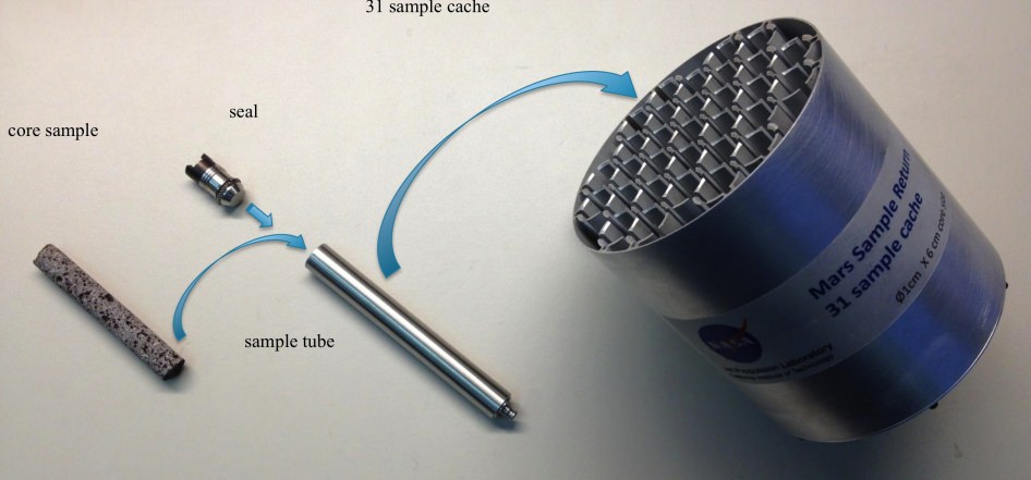
Creating a Returnable Cache of Martian Samples is a major objective for NASA’s Mars 2020 rover. This prototype show hardware to cache samples of cores drilled from Martian rocks for possible future return to Earth. The 2020 rover would be to collect and package a carefully selected set of up to 31 samples in a cache that could be returned to Earth by a later mission. The capabilities of laboratories on Earth for detailed examination of cores drilled from Martian rocks would far exceed the capabilities of any set of instruments that could feasibly be flown to Mars. The exact hardware design for the 2020 mission is yet to be determined. For scale, the diameter of the core sample shown in the image is 0.4 inch (1 centimeter). Credit: NASA/JPL-Caltech
The 2020 rover will be designed to make real progress on sample return for the first time. It will be capable of coring into rocks and storing 31 highly compelling Martian samples for return by a follow on mission to the Red Planet.
“But the timing on actually returning those samples to Earth is yet to be determined,” said John Grunsfeld, NASA’s associate administrator for science in Washington.
Everything NASA does is budget driven and the fiscal climate is rather gloomy right now.
“Crafting the science and exploration goals is a crucial milestone in preparing for our next major Mars mission,” said John Grunsfeld, NASA’s associate administrator for science in Washington, in a statement.
Work on the new rover must begin soon in order to achieve the mandatory 2020 launch deadline. Launch opportunities to Mars only open every 26 months and delays could balloon the costs by several hundred million dollars.
“The objectives determined by NASA with the input from this team will become the basis later this year for soliciting proposals to provide instruments to be part of the science payload on this exciting step in Mars exploration,” adds Grunsfeld.
“The 2020 rover will take a major step in ‘seeking signs of life” said Jim Green, director of NASA’s Planetary Science Division in Washington, at the briefing. “NASA will issue a call for science instruments this fall.”
The new mission would build upon the demonstrated science accomplishments of earlier missions like Curiosity, Spirit, Opportunity and Phoenix while vastly advancing the capabilities of the robots research instruments.
“Here’s the bottom line. Questions drive science,” explained Lindy Elkins-Tanton, SDT member and director of the Carnegie Institution for Science’s Department of Terrestrial Magnetism, Washington.
“We should be seeking to answer the very biggest questions. And one of the very biggest questions for all of humankind is – ‘Are we alone?’ And that is the question we’re hoping to make really big advances with on with this Mars 2020 mission.”
Grunsfeld explained that NASA has budgeted “for a mission cost of $1.5 Billion plus the cost of the launcher.”
The 2020 rover chassis, with some modifications, will be based on the blueprints of the highly successful Curiosity rover to keep down the cost and minimize risks. But the science instruments will be completely new and updated.
NASA’s 1 ton Curiosity rover touched down nearly a year ago and has already discovered that the Red Planet has the chemical ingredients and environmental conditions for a habitable zone that could have supported living Martian microbes.
The next logical step is to look for the ancient signs of life that would be preserved in the rock record on Mars.
NASA’s 2020 Mars rover would be based on the Curiosity rover which touched down inside Gale Crater on Aug. 6, 2012 and discovered a habitable zone here. This photomosic shows NASA’s Curiosity departing Glenelg work site area at last for Mount Sharp- her main science destination, seen at top left. Note the wheel tracks on the Red Planet’s surface. The mosaic of navcam camera images was stitched from photos taken on July 4, 2013 (Sol 324). Credit: NASA/JPL-Caltech/Ken Kremer (kenkremer.com)/Marco Di Lorenzo
This photomosic shows NASA’s Curiosity departing at last for Mount Sharp- her main science destination. Note the wheel tracks on the Red Planet’s surface. The navcam camera images were taken on July 4, 2013 (Sol 324). Credit: NASA/JPL-Caltech/Ken Kremer (kenkremer.com)/Marco Di Lorenzo
NASA’s Curiosity rover has at last begun her epic trek to the layered slopes of mysterious Mount Sharp – the mission’s primary destination which looms supreme inside the Gale Crater landing site.
Scientists expect to discover signatures of the chemical ingredients that potentially are markers for a Martian habitable zone, while climbing up Mount Sharp.
On July 4 (Sol 324), the six wheeled robot started driving away from the Glenelg and Yellowknife Bay areas where she has worked more than half a year investigating the alien terrain and drilling into Martian rocks for the first time in history.
“We have started the long traverse to the base of Mt. Sharp (Aeolis Mons), the long-term goal of the mission!” announced science team member Ken Herkenhoff of the USGS.
So far the NASA rover already driven more than 190 feet (58 meters) over two excursions on July 4 and 7, away from her last science campaign at the Shaler outcrop of cross-bedded, sedimentary outcrops. Another drive is planned today.
Billions of years of Mars geologic history are preserved in the sedimentary layers of Mount Sharp- including the ancient time period when the Red Planet was far wetter and warmer than today, and thus more hospitable to the origin of life.
Billion-Pixel View From Curiosity at Rocknest, Raw Color. This full-circle view combined nearly 900 images taken by NASA’s Curiosity Mars rover, generating a panorama with 1.3 billion pixels in the full-resolution version. The view is centered toward the south, with north at both ends. It shows Curiosity at the “Rocknest” site where the rover scooped up samples of windblown dust and sand. Curiosity used three cameras to take the component images on several different days between Oct. 5 and Nov. 16, 2012. Credit: NASA/JPL-Caltech/MSSS
The huge mountain rises about 3.4 miles (5.5 km) from the center of Gale Crater. Its taller than Mount Ranier in Washington State.
The overland journey could take nearly a year or even longer into 2014 to arrive at the base of Mount Sharp, depending on what the 1 ton behemoth sees along the way.
And the scientists are eager to make as many discoveries as possible.
“The mission is discovery driven,” says John Grotznger of the California Institute of Technology in Pasadena, Calif., who leads NASA’s Curiosity Mars Science Laboratory mission. “We will go to where the science takes us.”
This is a cropped, reduced version of panorama from NASA’s Mars rover Curiosity with 1.3 billion pixels in the full-resolution version see full panorama above. It shows Curiosity at the “Rocknest” site where the rover scooped up samples of windblown dust and sand. Curiosity used three cameras to take the component images on several different days between Oct. 5 and Nov. 16, 2012. Viewers can explore this image with pan and zoom controls at http://mars.nasa.gov/bp1/. Credit: NASA/JPL-Caltech/MSSS
NASA chose Gale Crater as the landing site specifically to dispatch Curiosity to investigate the sedimentary layers of Mount Sharp because in surveys from Mars orbit it exhibited signatures of clay minerals that form in neutral water and that could possibly support the origin and evolution of simple Martian life forms, past or present.
“We have a real desire to get to Mount Sharp because there we see variations in the mineralogy as we go up from the base to higher levels and a change in the record of the environment,” explained Joy Crisp of JPL, Curiosity’s deputy project scientist.
“If we pass something amazing and compelling we might turn around and drive back,” Crisp added.
“The challenge for the science team will be to identify the most important targets along the way, and to study them without delaying drive progress too much,” notes Herkenoff.
Mount Sharp lies about 5 miles (8 kilometers) distant – as the Martian crow flies.
And Curiosity must also pass through a potentially treacherous dune field to get there.
“We are looking for the best path though,” said Curiosity Project Manager Jim Erickson of NASA’s Jet Propulsion Laboratory, Pasadena, Calif. at a recent media briefing.
Fisheye view of Mount Sharp from the hazcam camera on July 6, 2013 (Sol 326). Credit: NASA/JPL-Caltech
11 months ago on Aug. 6 , 2012, Curiosity made an unprecedented pinpoint touchdown inside Gale Crater using the never before used Sky crane descent thrusters.
Long before even arriving at destination Mount Sharp, Curiosity has already successfully accomplished the key science objective of the mission when she discovered that liquid water flowed at this spot on Mars, it possesses the key chemical ingredients required for life and was habitable in the past.
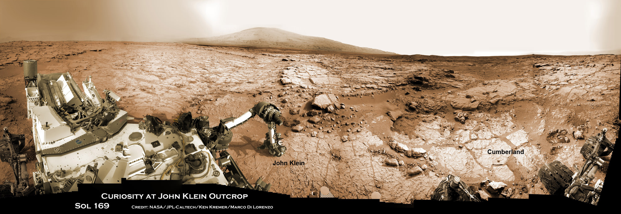
Drill samples from the ‘John Klein’ outcrop at Yellowknife Bay analyzed by Curiosity’s pair of onboard chemistry labs – SAM & Chemin – revealed that this location contains clay minerals required to support microbial life forms.
“We have found a habitable environment [at John Klein] which is so benign and supportive of life that probably if this water was around, and you had been on the planet, you would have been able to drink it,” said Grotzinger.
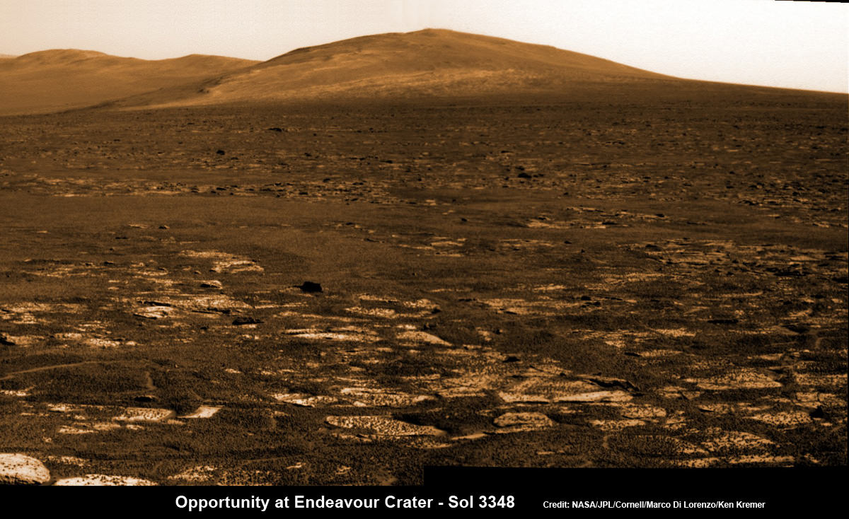
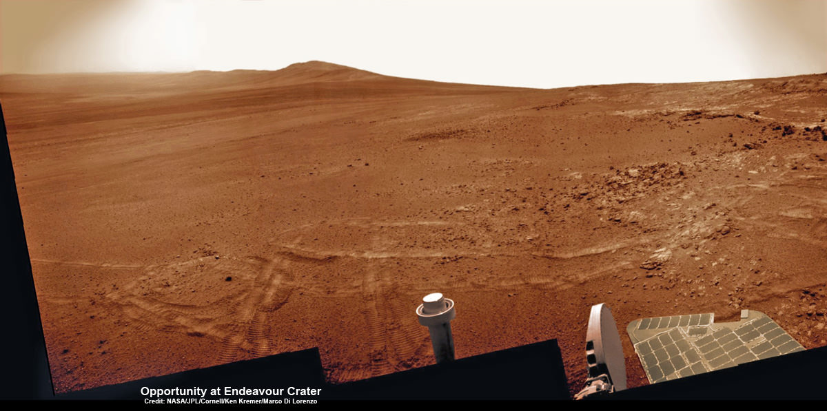
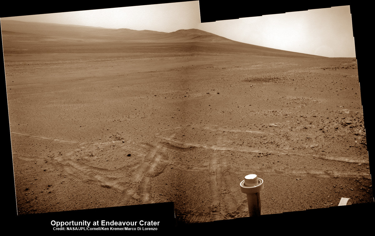
Opportunity rover’s view across Botany Bay to Solander Point - her next destination - as NASA celebrates 10 Years since blastoff for Mars on July 7, 2003. The rover will climb up Solander Point because it which may harbor clay minerals indicative of a past Martian habitable environment. This pancam mosaic was assembled from raw images taken on Sol 3348 (June 24, 2013. Credit: NASA/JPL/Cornell/ASU/Marco Di Lorenzo/Ken Kremer (kenkremer.com)
Opportunity rover’s view across Botany Bay to Solander Point – her next destination – as NASA celebrates 10 Years since blastoff for Mars on July 7, 2003. The rover will climb up Solander Point because it which may harbor clay minerals indicative of a past Martian habitable environment. This pancam mosaic was assembled from raw images taken on Sol 3348 (June 24, 2013.
Credit: NASA/JPL/Cornell/ASU/Marco Di Lorenzo/Ken Kremer (kenkremer.com)[/caption]
Today, NASA’sOpportunity rover marks a magical moment celebrating 10 years since launching to Mars on July 7, 2003 and with her impending Mountain destination filling the camera’s eye view.
The now legendary robot has vastly exceeded everyone’s expectations. Back in 2003 the science team promised us a mere 90 day ‘warranty’ following the suspenseful airbag landing on Jan. 24, 2004 at Meridiani Planum.
Today is Martian Day (or Sol) 3360. That amounts to a life expectancy and exploration ‘bonus’ of more than 37 times beyond the design lifetime.
Launch of NASA’s 2nd Mars Exploration Rover, Opportunity, aboard a Delta II Heavy rocket to Mars on July 7, 2003 at 11:18 p.m. EDT from Pad 17-B at Cape Canaveral Air Force Station, Fla. Credit: NASA
Opportunity’s twin sister Spirit blasted off three weeks earlier in June 2003 and continued functioning until 2010.
“I never thought we’d achieve nine months!” Principal Investigator Prof. Steve Squyres of Cornell University told me recently on the occasion of the rovers 9th anniversary on Mars in January 2013.
As you read this, the now decade old rover Opportunity is blazing a trail toward’s the oldest geological deposits she has ever explored – at a place called Solander Point, a raised ridge along the eroded rim of huge Endeavour Crater.
Opportunity has surpassed the halfway point in the traverse from the rim segment she has explored the past 22 months at ‘Cape York’ to her next rim segment destination at Solander.
From tip to tip, Cape York and Solander Point lie 1.2-mile (2-kilometer) apart along the western rim of Endeavour Crater. Both are raised portions of 14-mile-wide (22-kilometer-wide) Endeavour.
The rover has less than half a mile (800 meters) to go to finish the Martian dash from one rim segment to the next across an area called ‘Botany Bay’.
This view from July 2, 2013 (Sol 3355) shows the terrain that NASA’s Mars Exploration Rover Opportunity is crossing in a flat area called “Botany Bay” on the way toward “Solander Point,” which is visible on the horizon. Credit: NASA/JPL-Caltech
“We are making very good progress crossing ‘Botany Bay,’ said John Callas of NASA’s Jet Propulsion Laboratory, Pasadena, Calif., who is project manager for the mission now entering its 2nd decade.
The flat terrain of fractured, light-toned bedrock is devoid of treacherous dunes and is easy to drive across, almost like a highway, which simplifies the daily planning by the rovers Earthly handlers.
“The surface that Opportunity is driving across in Botany Bay is polygonally fractured outcrop that is remarkably good for driving,” said Brad Joliff, an Opportunity science team member and long-term planner at Washington University in St. Louis. “The plates of outcrop, like a tiled mosaic pavement, have a thin covering of soil, not enough to form the wind-blown ripples we’ve had to deal with during some other long treks. The outcrop plates are light-toned, and the cracks between them are filled with dark, basaltic soil and our old friends the ‘blueberries.”
The “blueberries” are hematite-rich, erosion-resistant concretions about the size of BB’s that Opportunity discovered when she first opened her eyes at her Eagle crater landing site. During the multi year crater hopping tour that ensued, the rover continued finding patches of blueberries all the way to Endeavour crater.
1st color panorama taken by Opportunity after landing inside Eagle Crater on Jan. 24, 2004. Credit: NASA/JPL/Cornell
Opportunity is expected to arrive at Solander’s foothills sometime in August – before the onset of the next southern hemisphere Martian winter, her 6th altogether.
Opportunity will scale Solander to continue the science quest in search of additional evidence of habitable environments with the chemical ingredients necessary to sustain Martian microbial life.
“Right now the rover team is discussing the best way to approach and drive up Solander,” Ray Arvidson told Universe Today. Arvidson is the mission’s deputy principal scientific investigator from Washington University in St. Louis, Mo.
‘Solander Point’ offers roughly about a 10 times taller stack of geological layering compared to ‘Cape York.’
Solander also offers north facing slopes where Opportunity’s solar wings can more effectively soak up the sun’s rays to generate life giving electrical power.
The robot remains in excellent health.
The total driving distance exceeds 23 miles (37 kilometers). She has snapped over 181,000 images.
Meanwhile on the opposite side of Mars at Gale Crater, Opportunity’s younger sister rover Curiosity also discovered a habitable environment originating from a time when the Red Planet was far warmer and wetter billions of years ago.
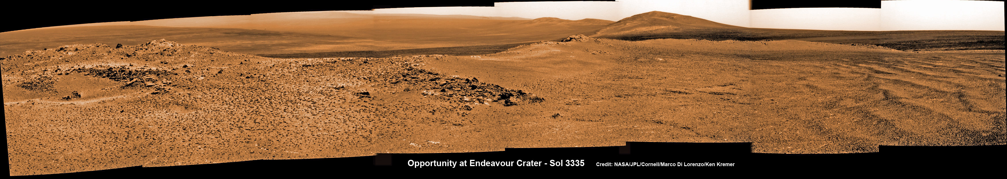
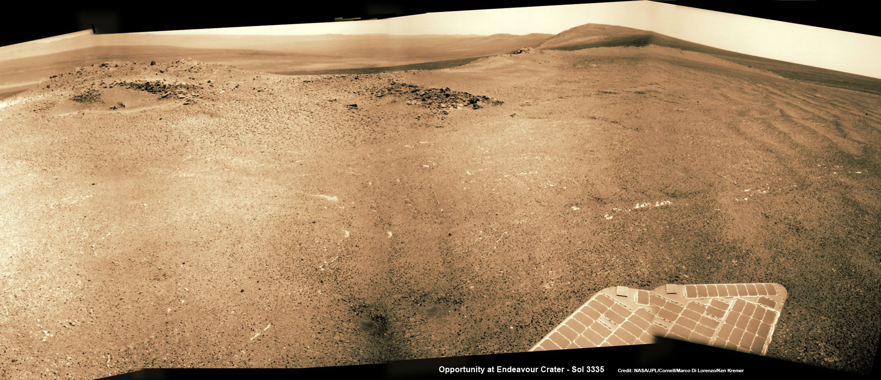
Opportunity captures spectacular panoramic view ahead to her upcoming mountain climbing goal, the raised rim of “Solander Point” at right, located along the western edge of Endeavour Crater. It may harbor clay minerals indicative of a habitable zone. The rise at left is “Nobbys Head” which the rover just passed on its southward drive to Solander Point from Cape York. This pancam photo mosaic was taken on Sol 3335, June 11, 2013 shows vast expanse of the central crater mound and distant Endeavour crater rim. Credit: NASA/JPL/Cornell/ASU/Marco Di Lorenzo/Ken Kremer (kenkremer.com) Traverse Map for NASA’s Opportunity rover from 2004 to 2013
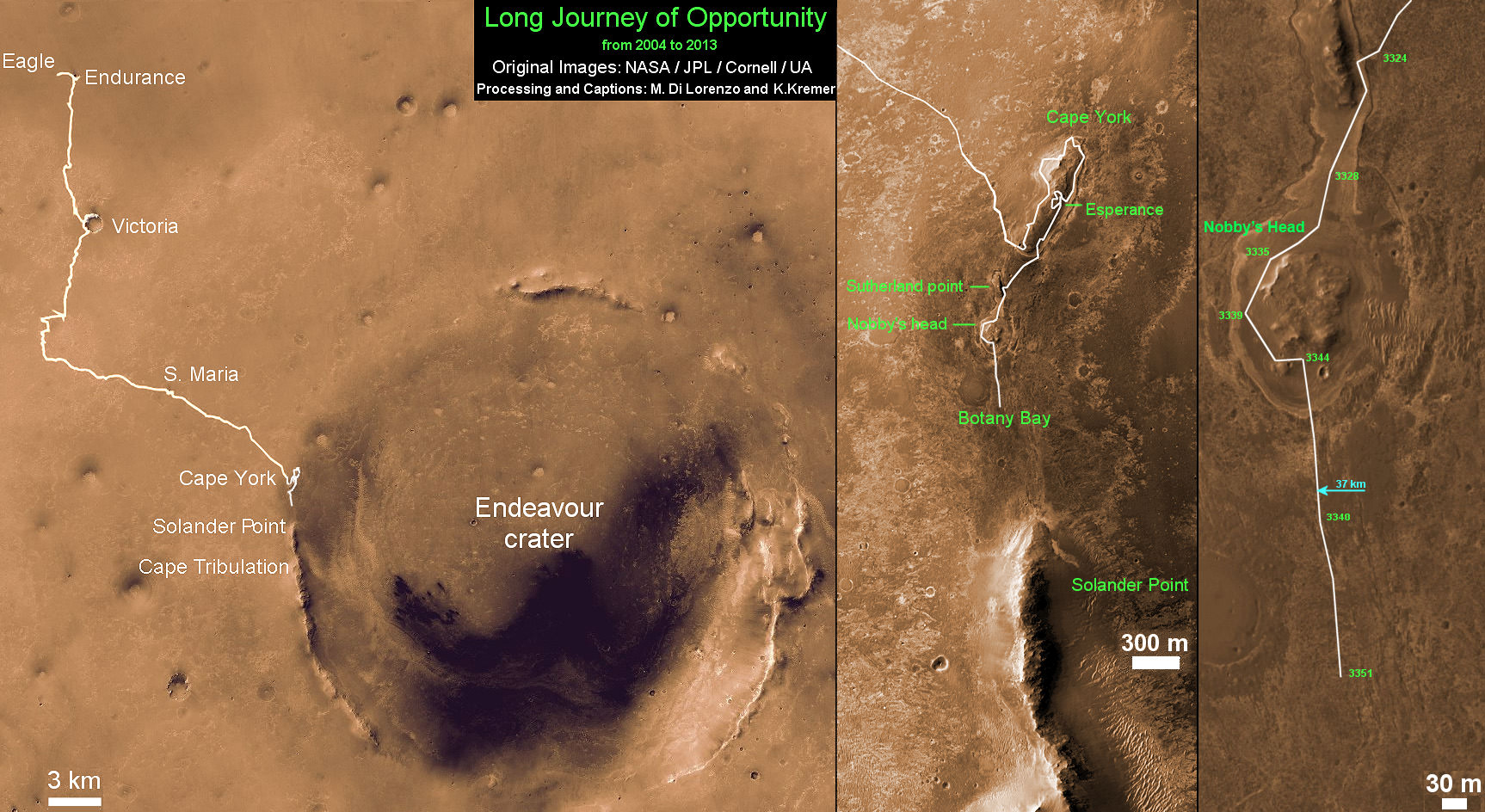
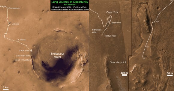
This map shows the entire path the rover has driven during more than 9 years and over 3360 Sols, or Martian days, since landing inside Eagle Crater on Jan 24, 2004 to current location heading south to Solander Point from Cape York ridge at the western rim of Endeavour Crater. Credit: NASA/JPL/Cornell/ASU/Marco Di Lorenzo/Ken Kremer
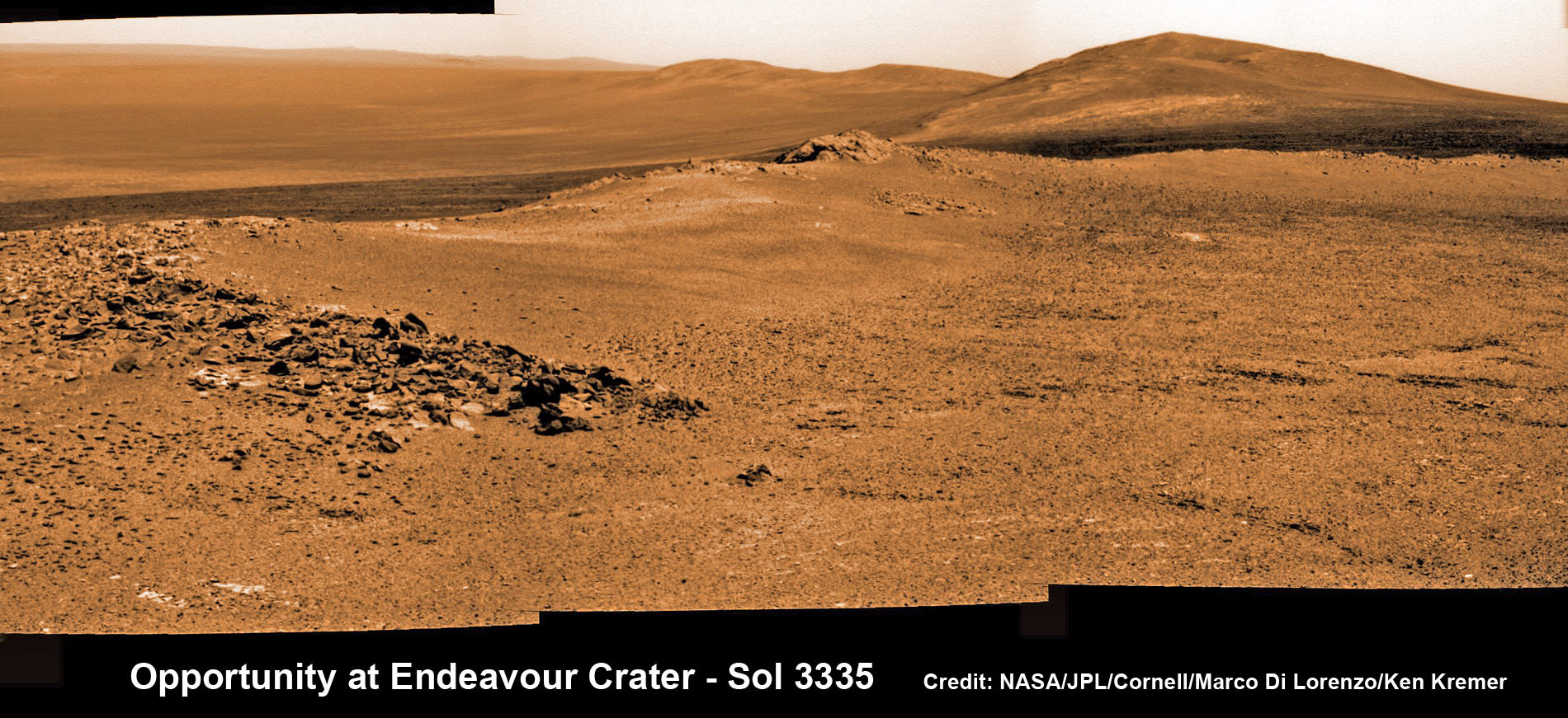
Opportunity rover captures spectacular view ahead to her upcoming mountain climbing goal, the raised rim of “Solander Point” at right, located along the western edge of Endeavour Crater. It may harbor clay minerals indicative of a habitable zone. This pancam photo mosaic was taken on Sol 3335, June 11, 2013. Credit: NASA/JPL/Cornell/ASU/Marco Di Lorenzo/Ken Kremer (kenkremer.com) See full panoramic scene below
Opportunity rover captures spectacular view ahead to her upcoming mountain climbing goal, the raised rim of “Solander Point” at right, located along the western edge of Endeavour Crater. It may harbor clay minerals indicative of a habitable zone. This pancam photo mosaic was taken on Sol 3335, June 11, 2013. Credit: NASA/JPL/Cornell/ASU/Marco Di Lorenzo/Ken Kremer (kenkremer.com)
See full panoramic scene – below Your last chance to “Send Your Name to Mars aboard NASA’s MAVEN orbiter” – below[/caption]
NASA’s nearly decade old Opportunity Mars rover is sailing swiftly on a southerly course towards her first true mountain climbing destination – named “Solander Point” – in search of further evidence of habitable environments with the chemical ingredients necessary to sustain Martian life forms.
At Solander Point, researchers have already spotted deep stacks of ancient rocks transformed by flowing liquid water eons ago. It is located along the western rim of huge Endeavour Crater.
“Right now the rover team is discussing the best way to approach and drive up Solander,” Ray Arvidson told Universe Today. Arvidson is the mission’s deputy principal scientific investigator from Washington University in St. Louis, Mo.
Solander Point may harbor clay minerals in the rock stacks indicative of a past Martian habitable zone.
“One idea is to drive part way up Solander from the west side of the rim, turn left and then drive down the steeper north facing slopes with the stratographic sections,” Arvidson told me.
“That way we don’t have to drive up the relatively steeper slopes. The rover can drive up rocky surfaces inclined about 12 to 15 degrees.”
“We want to go through the stratographic sections on the north facing sections.”
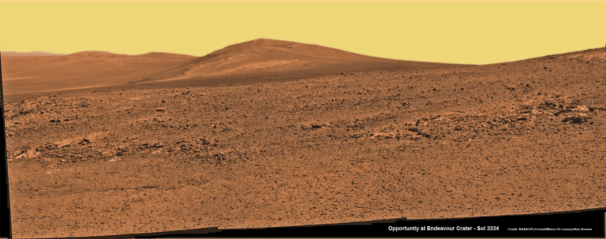
Solander Point mosaic captured by high resolution pancam camera on Sol 3334, June 10, 2013. Opportunity will scale Solander after arriving in August 2013 in search of chemical ingredients to sustain Martian microbes Credit: NASA/JPL/Cornell/ASU/Marco Di Lorenzo/Ken Kremer (kenkremer.com)
The science team hopes that by scaling Solander, Opportunity will build on her recent historic discovery of a habitable environment at a rock called “Esperance” that possesses a cache of phyllosilicate clay minerals.
These aluminum rich clay minerals typically form in neutral, drinkable water that is not extremely acidic or basic and therefore could support a path to potential Martian microbes.
“Esperance ranks as one of my personal Top 5 discoveries of the mission,” said Steve Squyres of Cornell University, Ithaca, N.Y., principal investigator for NASA’s rover mission at a recent media briefing.
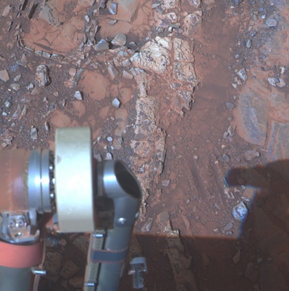
‘Esperance’ Target Examined by Opportunity in May 2013. The pale rock called “Esperance,” has a high concentration of clay minerals formed in near neutral water indcating a spot favorable for life. Credit: NASA/JPL-Caltech/Cornell Univ./Arizona State Univ.
Using high resolution CRISM spectral data collected from Mars orbit, the rover was specifically directed to Esperance, Arvidson explained. The rock was found about a kilometer back on Matijevic Hill at ‘Cape York’, a rather low hilly segment of the western rim of giant Endeavour crater which spans 14 miles (22 km) across.
‘Solander Point’ offers roughly about a 10 times taller stack of geological layering compared to ‘Cape York.’ Both areas are raised segments of the western rim of Endeavour Crater.
The team is working now to obtain the same type of high resolution spectral evidence for phyllosilicate clay minerals at Solander as they had at Cape York to aid in targeting Opportunity to the most promising outcrops, Arvidson explained.
Opportunity is snapping ever more spectacular imagery of Solander Point and the eroded rim of Endeavour Crater as she approaches closer every passing Sol, or Martian Day. See our original photo mosaics herein by Marco Di Lorenzo and Ken Kremer.
Opportunity captures spectacular panoramic view ahead to her upcoming mountain climbing goal, the raised rim of “Solander Point” at right, located along the western edge of Endeavour Crater. It may harbor clay minerals indicative of a habitable zone. The rise at left is “Nobbys Head” which the rover just passed on its southward drive to Solander Point from Cape York. This pancam photo mosaic was taken on Sol 3335, June 11, 2013 shows vast expanse of the central crater mound and distant Endeavour crater rim.
Credit: NASA/JPL/Cornell/ASU/Marco Di Lorenzo/Ken Kremer (kenkremer.com)
The long lived robot arrived at the edge of Endeavour crater in mid-2011 and will spend her remaining life driving around the scientifically rich crater rim segments.
On June 21, 2013, Opportunity marked five Martian years on Mars since landing on Jan 24, 2004 with a mere 90 day (Sol) ‘warranty’.
This week Opportunity’s total driving distance exceeded 23 miles (37 kilometers).
The solar powered robot remains in excellent health and the life giving solar arrays are producing plenty of electrical power at the moment.
Solander Point also offers northerly tilled slopes that will maximize the power generation during Opportunity’s upcoming 6th Martian winter .
The rover handlers want Opportunity to reach Solander’s slopes by August, before winter’s onset.
As ot today (tosol) Opportunity has trekked about halfway from Cape York to Solander Point – tip to tip.
On the opposite side of Mars at Gale Crater, Opportunity’s younger sister rover Curiosity also discovered clay minerals and a habitable environment originating from a time when the Red Planet was far warmer and wetter billions of years ago.
And this is your last chance to “Send Your Name to Mars” aboard NASA’s MAVEN orbiter- details here. Deadline: July 1, 2013. Launch: Nov. 18, 2013
Wide angle view of Endeavour Crater showing Solander Point and Cape Tribulation in this photo mosaic captured by navcam camera on Sol 3335, June 11, 2013. Opportunity will scale Solander after arriving in August 2013 in search of chemical ingredients to sustain Martian microbes. Credit: NASA/JPL/Cornell/Marco Di Lorenzo/Ken Kremer (kenkremer.com)Traverse Map for NASA’s Opportunity rover from 2004 to 2013. This map shows the entire path the rover has driven during more than 9 years and over 3351 Sols, or Martian days, since landing inside Eagle Crater on Jan 24, 2004 to current location heading south to Solander Point from Cape York ridge at the western rim of Endeavour Crater. Credit: NASA/JPL/Cornell/ASU/Marco Di Lorenzo/Ken Kremer
Opportunity captures a panoramic view of the road ahead to the raised rim of Solander Point (at left) which is some 0.8 mile (1.3 km) away. Arrival is targeted for August. It features a thick strata of ancient rocks which may harbor clay minerals indicative of a habitable zone and northerly tilted slopes to maximize power generation from the solar panels during upcoming 6th winter season at Endeavour crater rim. This navcam photo mosaic was taken on Sol 3330, June 6, 2013. Credit: NASA/JPL/Cornell//Marco Di Lorenzo/Ken Kremer (kenkremer.com)
On the cusp of the 10th anniversary since launching to the Red Planet, NASA’s long lived Opportunity rover has discovered a habitable zone on Mars that once coursed with ‘drinkable water’ and possesses the chemical ingredients necessary to support a path to potential Martian microbes.
At a rock called “Esperance”, Opportunity found a cache of phyllosilicate clay minerals that typically form in neutral, drinkable water that is not extremely acidic or basic.
The finding ranks as “One of my personal Top 5 discoveries of the mission,” said Steve Squyres of Cornell University, Ithaca, N.Y., principal investigator for NASA’s rover mission at a media briefing.
And despite her advancing age Opportunity remains healthy after surviving in excess of an incredible 3333 Sols, or days, trekking across the alien and ever harsh Martian crater plains.
Furthermore the intrepid robot just sat sail on a southerly course for a new destination called “Solander Point” where researches hope to find more even evidence of habitable environments since they already spotted deeper stakes of ancient rocks transformed by water eons ago. See our current photo mosaics showing Solander Point as Opportunity roves across the crater floor – above and below by Marco Di Lorenzo and Ken Kremer.
After weeks of trying, the rover deployed the robotic arm to drill at a sweet spot inside “Esperance” and collected convincing X-Ray spectroscopic data in the area she just investigated in May 2013 around the eroded rim of giant Endeavour Crater.
“Esperance is rich in clay minerals and shows powerful evidence of water alteration,” Squyres elaborated.
“This is the most powerful evidence we found for neutral pH water.”
“Clay minerals only tend to form at a more neutral pH. This is water you could drink,” Squyres gushed.
These finding represent the most favorable conditions for biology that Opportunity has yet seen in the rock histories it has encountered after nearly a decade roving the Red Planet.
“This is water that was much more favorable for things like pre-biotic chemistry – the kind of chemistry that could lead to the origin of life,” Squyres stated.
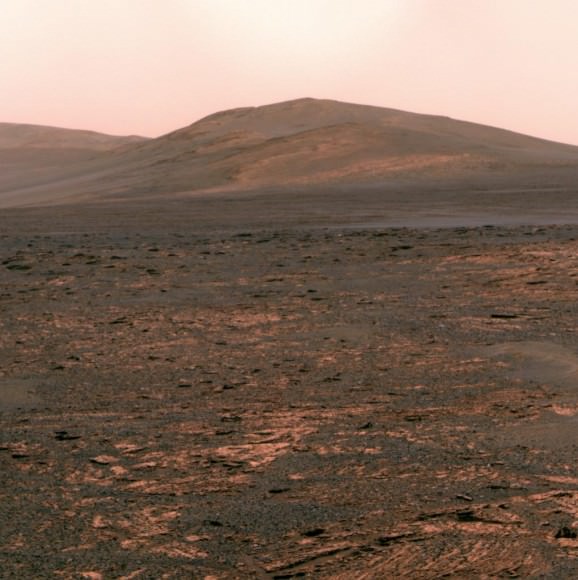
Opportunity snapped this color view of ‘Solander Point’ on June 1, 2013 (Sol 3325) looking south to her next destination which she should reach in August. The solar powered robot will spend the upcoming 6th winter season on northerly tilted slopes exploring the thick strata of ancient rocks. Credit: NASA/JPL-Caltech/Cornell Univ./Arizona State Univ.
Esperance is unlike any rock previously investigated by Opportunity; rich in aluminum, which is strongly indicative of clay minerals, perhaps like montmorillonite.
Most rocks inspected to date by Opportunity were formed in an environment of highly acidic water that is extremely harsh to most life forms.
“If you look at all of the water-related discoveries that have been made by Opportunity, the vast majority of them point to water that was a very low pH – it was acid,” Squyres explained.
Esperance was found on ‘Cape York’, a hilly segment of the western rim of Endeavour crater which spans 14 miles (22 km) across. The robot arrived at the edge of Endeavour crater in mid-2011 and will spend her remaining life driving around the scientifically rich crater rim segments.
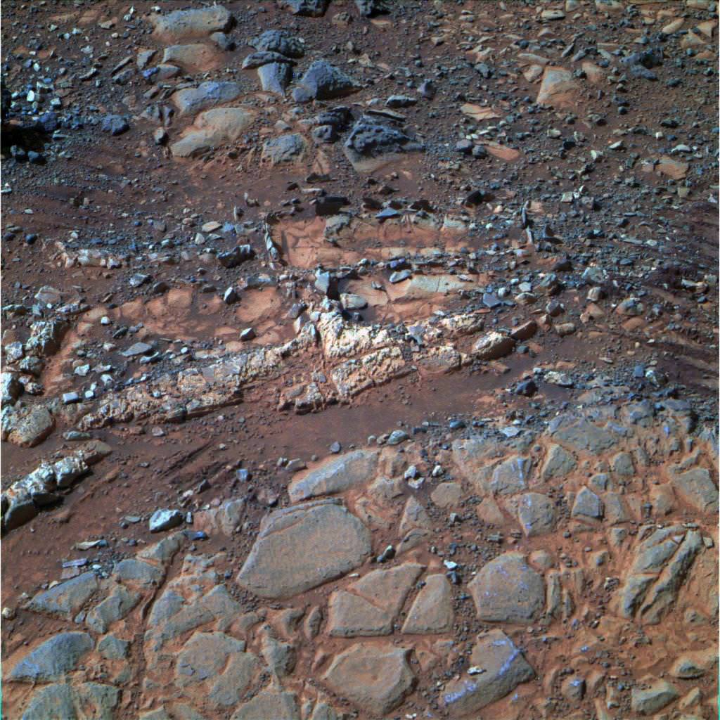
The pale rock in the upper center of this image, about the size of a human forearm, includes a target called “Esperance,” which was inspected by NASA’s Mars Exploration Rover Opportunity. Data from the rover’s alpha particle X-ray spectrometer (APXS) indicate that Esperance’s composition is higher in aluminum and silica, and lower in calcium and iron, than other rocks Opportunity has examined in more than nine years on Mars. Preliminary interpretation points to clay mineral content due to intensive alteration by water. Credit: NASA/JPL-Caltech/Cornell/Arizona State Univ
NASA’s new Curiosity rover also recently discovered clay minerals and a habitable environment at Gale Crater – on the other side of Mars – stemming from a time when Mars was warmer and wetter billions of years ago.
Over time Mars became the cold and dry place it is today. Scientists hope the rovers provide clues to Mars dramatic transformation.
The solar powered rover is now driving as quick as possible to reach the northerly tilled slopes of ‘Solander Point’ in August, before the onset of the next Martian winter.
‘Solander Point’ offers a much taller stack of geological layering than ‘Cape York.’ Both areas are raised segments of the western rim of Endeavour Crater.
“There’s a lot to explore there. In effect, it’s a whole new mission,” said Ray Arvidson, the mission’s deputy principal scientific investigator from Washington University in St. Louis, Mo.
‘Esperance’ Target Examined by Opportunity in May 2013. The pale rock called “Esperance,” has a high concentration of clay minerals formed in near neutral water indcating a spot favorable for life. Credit: NASA/JPL-Caltech/Cornell Univ./Arizona State Univ.
Opportunity and her twin “Spirit” were launched to Mars on planned 90 day missions.
Both rovers have far exceeded everyone’s wildest expectations. Spirit endured more than 6 years inside Gusev Crater until succumbing to the bone chilling Martian winter in 2011.
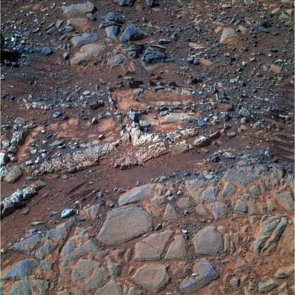
NASA’s Opportunity Mars rover discovered clay minerals at Cape York ridge along the rim of Endeavour crater – seen in this photo mosaic – which stands as the most favorable location for Martian biology discovered during her entire nearly 10 year long mission to Mars. Opportunity also established a new American driving record for a vehicle on another world on May 15, 2013 (Sol 3309) and made history by driving ahead from this point at Cape York. This navcam photo mosaic shows the view forward to her next destinations of Solander Point and Cape Tribulation along the lengthy rim of huge Endeavour crater spanning 14 miles (22 km) in diameter.
Credit: NASA/JPL/Cornell/Ken Kremer (kenkremer.com)/Marco Di Lorenzo
Opportunity has lasted more than 37 times beyond the three month “warranty”.
“This is like your car not lasting 200,000 miles, or even a million miles. You’re talking about a car that lasts 2 million miles without an oil change,” Callas said. “At this point, how long Opportunity lasts is anyone’s guess.”
“Remember, the rover continues to operate in a very hostile environment, where we have extreme temperature changes every day, and the rover could have a catastrophic failure at anytime,” said John Callas, of NASA’s Jet Propulsion Laboratory, Pasadena, Calif., project manager for the Mars Exploration Rover Project.
“So every day is a gift.”
And don’t forget to “Send Your Name to Mars” aboard NASA’s MAVEN orbiter- details here. Deadline: July 1, 2013
June 23: “Send your Name to Mars on MAVEN” and “CIBER Astro Sat, LADEE Lunar & Antares Rocket Launches from Virginia”; Rodeway Inn, Chincoteague, VA, 8 PM
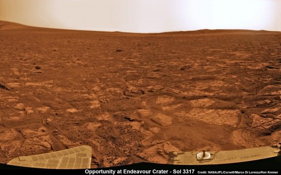
Opportunity captures the eerie Martian scenery looking south across Botany Bay from the southern tip of Cape York to her next destination – Solander Point, about 1 mile (1.6 km) away. This navcam photo mosaic was taken on Sol 3317, May 23, 2013. Credit: NASA/JPL/Cornell//Marco Di Lorenzo/Ken Kremer (kenkremer.com)Traverse Map for NASA’s Opportunity rover from 2004 to 2013.
This map shows the entire path the rover has driven during more than 9 years and over 3330 Sols, or Martian days, since landing inside Eagle Crater on Jan 24, 2004 to current location heading south to Solander Point from Cape York ridge at the western rim of Endeavour Crater.
Credit: NASA/JPL/Cornell/ASU/Marco Di Lorenzo/Ken Kremer
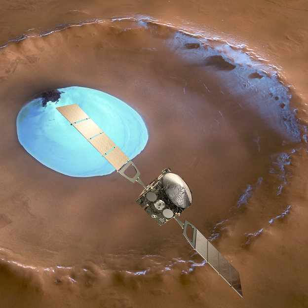
Mars Express over water-ice crater. ESA Celebrates 10 Years since the launch of Mars Express. This artists concept shows Mars Express set against a 35 km-wide crater in the Vastitas Borealis region of Mars at approximately 70.5°N / 103°E. The crater contains a permanent patch of water-ice that likely sits upon a dune field – some of the dunes are exposed towards the top left in this image. Copyright ESA/DLR/FU-Berlin-G.Neukum
This week marks the 10th anniversary since the launch of the European Space Agencies’ (ESA) Mars Express orbiter from the Baikonur Cosmodrome in Russia on June 2, 2003 and a decade of ground breaking science discoveries at the Red Planet.
2003 was a great year for Mars exploration as it also saw the dual liftoffs of NASA’s now legendary rovers Spirit & Opportunity from Cape Canaveral in Florida.
The immense quantity and quality of science data returned from Mars Express -simultaneously with Spirit and Opportunity – has completely transformed our understanding of the history and evolution of the Red Planet.
All three spacecraft have functioned far beyond their original design lifetime.
Earth’s exploration fleet of orbiters, landers and rovers have fed insights to each other that vastly multiplied the science output compared to working solo during thousands and thousands of bonus Sols at Mars.
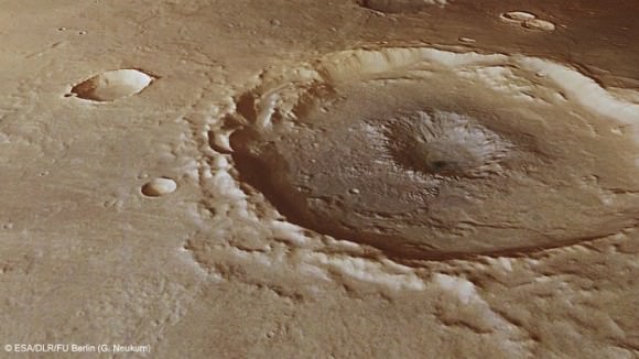
Inside a central pit crater. Perspective view of a 50 km diameter crater in Thaumasia Planum. The image was made by combining data from the High-Resolution Stereo Camera on ESA’s Mars Express with digital terrain models. The image was taken on 4 January 2013, during orbit 11467, and shows a close up view of the central ‘pit’ of this crater, which likely formed by a subsurface explosion as the heat from the impact event rapidly vapourised water or ice lying below the surface. Copyright ESA/DLR/FU-Berlin-G.Neukum
Mars Express derived its name from an innovative new way of working in planetary space science that sped up the development time and cut costs in the complex interactive relationships between the industrial partners, space agencies and scientists.
Indeed the lessons learned from building and operating Mars Express spawned a sister ship, Venus Express that also still operates in Venusian orbit.
Mars Express (MEX) achieved orbit in December 2003.
MEX began science operations in early 2004 with an array of seven instruments designed to study all aspects of the Red Planet, including its atmosphere and climate, and the mineralogy and geology of the surface and subsurface with high resolution cameras, spectrometers and radar.
The mission has been granted 5 mission extensions that will carry it to at least 2014.
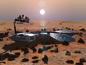
The mission has been wildly successful except for the piggybacked lander known as Beagle 2, which was British built.
Beagle 2The ambitious British lander was released from the mothership on December 19, 2003, six days before MEX braked into orbit around Mars. Unfortunately the Beagle 2 was never heard from again as it plummeted to the surface and likely crashed.
The high resolution camera (HRSC) has transmitted thousands of dramatic 3D images all over Mars ranging from immense volcanoes, steep-walled canyons, dry river valleys, ancient impact craters of all sizes and shapes and the ever-changing polar ice caps.
It carried the first ever radar sounder (MARSIS) to orbit another planet and has discovered vast caches of subsurface water ice.
MEX also played a significant role as a data relay satellite for transmissions during the landings of NASA’s Phoenix lander and Curiosity rover. It also occasionally relays measurements from Spirit & Opportunity to NASA.
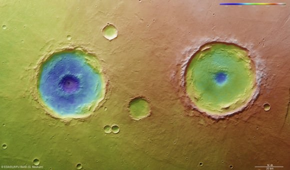
Arima twins topography. This colour-coded overhead view is based on an ESA Mars Express High-Resolution Stereo Camera digital terrain model of the Thaumasia Planum region on Mars at approximately 17°S / 296°E. The image was taken during orbit 11467 on 4 January 2013. The colour coding reveals the relative depth of the craters, in particular the depths of their central pits, with the left-hand crater penetrating deeper than the right (Arima crater). Copyright: ESA/DLR/FU-Berlin-G.Neukum
Here is a list of the Top 10 Discoveries from Mars Express from 2003 to 2013:
Mars Express mineralogy maps. This series of five maps shows near-global coverage of key minerals that help plot the history of Mars. The map of hydrated minerals indicates individual sites where a range of minerals that form only in the presence of water were detected. The maps of olivine and pyroxene tell the story of volcanism and the evolution of the planet’s interior. Ferric oxides, a mineral phase of iron, are present everywhere on the planet: within the bulk crust, lava outflows and the dust oxidised by chemical reactions with the martian atmosphere, causing the surface to ‘rust’ slowly over billions of years, giving Mars its distinctive red hue. Copyright: ESA/CNES/CNRS/IAS/Université Paris-Sud, Orsay; NASA/JPL/JHUAPL; Background images: NASA MOLA#1. First detection of hydrated minerals in the form of phyllosilicates and hydrated sulfates – evidence of long periods of flowing liquid water from the OMEGA visible and infrared spectrometer provided confirmation that Mars was once much wetter than it is today and may have been favorable for life to evolve.
#2. Possible detection of methane in the atmosphere from the Planetary Fourier Spectrometer (PFS) which could originate from biological or geological activity.
#3. Identification of recent glacial landforms via images from the High Resolution Stereo Camera (HRSC) are stem from viscous flow features composed of ice-rich material derived from adjacent highlands.
#4. Probing the polar regions. OMEGA and MARSIS determined that the south pole consists of a mixture frozen water ice and carbon dioxide. If all the polar ice melted the planet would be covered by an ocean 11 meters deep.
#5. Recent and episodic volcanism perhaps as recently as 2 million years ago. Mars has the largest volcanoes in the solar system . They are a major factor in the evolution of the martian surface, atmosphere and climate.
#6. Estimation of the current rate of atmospheric escape, helps researchers explain how Mars changed from a warm, wet place to the cold, dry place it is today.
#8. A new, meteoric layer in the martian ionosphere created by fast-moving cosmic dust which burns up as it hits the atmosphere.
#9. Unambiguous detection of carbon dioxide clouds. The freezing and vaporisation of CO2 is one of the main climatic cycles of Mars, and it controls the seasonal variations in surface air pressure.
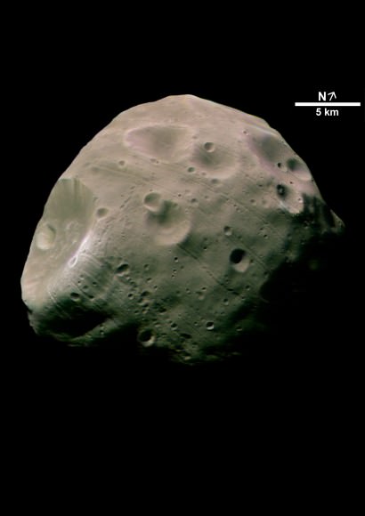
#10. Unprecedented probing of the Martian moon Phobos – which could be a target for future landers and human missions.
The Mars-facing side of Phobos. Credit: ESA/DLR/FU Berlin (G. Neukum)
And don’t forget to “Send Your Name to Mars” aboard NASA’s MAVEN orbiter- details here. Deadline: July 1, 2013
June 23: “Send your Name to Mars on MAVEN” and “CIBER Astro Sat, LADEE Lunar & Antares Rocket Launches from Virginia”; Rodeway Inn, Chincoteague, VA, 8 PM
Opportunity established a new American driving record for a vehicle on another world on May 15, 2013 (Sol 3309) and made history by driving ahead from this point at Cape York. This navcam mosaic shows the view forward to her next destinations of Solander Point and Cape Tribulation along the lengthy rim of huge Endeavour crater spanning 14 miles (22 km) in diameter. Opportunity discovered clay minerals at Cape York and stands as the most favorable location for Martian biology discovered during her entire nearly 10 year long mission to Mars. Credit: NASA/JPL/Cornell/Kenneth Kremer/Marco Di Lorenzo
NASA’s Opportunity Mars rover discovered clay minerals at Cape York ridge along the rim of Endeavour crater – seen in this photo mosaic – which stands as the most favorable location for Martian biology discovered during her entire nearly 10 year long mission to Mars. Opportunity also established a new American driving record for a vehicle on another world on May 15, 2013 (Sol 3309) and made history by driving ahead from this point at Cape York. This navcam photo mosaic shows the view forward to her next destinations of Solander Point and Cape Tribulation along the lengthy rim of huge Endeavour crater spanning 14 miles (22 km) in diameter.
Credit: NASA/JPL/Cornell/Ken Kremer (kenkremer.com)/Marco Di Lorenzo Updated: Illustrated below with a collection of imagery, mosaics and route maps[/caption]
Now nearly a decade into her planned 3 month only expedition to Mars, NASA’s longest living rover Opportunity, struck gold and has just discovered the strongest evidence to date for an environment favorable to ancient Martian biology – and she has set sail hunting for a motherlode of new clues amongst fabulous looking terrain!!
Barely two weeks ago in mid-May 2013, Opportunity’s analysis of a new rock target named “Esperance” confirmed that it is composed of a “clay that had been intensely altered by relatively neutral pH water – representing the most favorable conditions for biology that Opportunity has yet seen in the rock histories it has encountered,” NASA said in a statement.
The finding of a fractured rock loaded with clay minerals and ravaged by flowing liquid water in which life could have thrived amounts to a scientific home run for the golf cart sized rover!
“Water that moved through fractures during this rock’s history would have provided more favorable conditions for biology than any other wet environment recorded in rocks Opportunity has seen,” said the mission’s principal investigator Prof. Steve Squyres of Cornell University, Ithaca, N.Y.
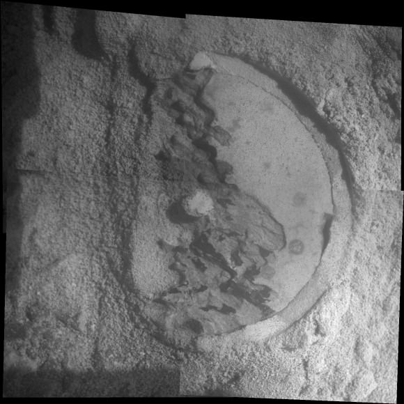
Opportunity accomplished the ground breaking new discovery by exposing the interior of Esperance with her still functioning Rock Abrasion Tool (RAT) and examining a pristine patch using the microscopic camera and X-Ray spectrometer on the end of her 3 foot long robotic arm.
The pale rock in the upper center of this image, about the size of a human forearm, includes a target called “Esperance,” which was inspected by NASA’s Mars Exploration Rover Opportunity. Data from the rover’s alpha particle X-ray spectrometer (APXS) indicate that Esperance’s composition is higher in aluminum and silica, and lower in calcium and iron, than other rocks Opportunity has examined in more than nine years on Mars. Preliminary interpretation points to clay mineral content due to intensive alteration by water. Credit: NASA/JPL-Caltech/Cornell/Arizona State Univ
The robot made the discovery at the conclusion of a 20 month long science expedition circling around a low ridge called “Cape York” – which she has just departed on a southerly heading trekking around the eroded rim of the huge crater named “Endeavour.”
“Esperance was so important, we committed several weeks to getting this one measurement of it, even though we knew the clock was ticking.”
Esperance stems from a time when the Red Planet was far warmer and wetter billions of years ago.
“What’s so special about Esperance is that there was enough water not only for reactions that produced clay minerals, but also enough to flush out ions set loose by those reactions, so that Opportunity can clearly see the alteration,” said Scott McLennan of the State University of New York, Stony Brook, a long-term planner for Opportunity’s science team.
Close-Up of ‘Esperance’ After Abrasion by Opportunity This mosaic of four frames shot by the microscopic imager on the robotic arm of NASA’s Mars Exploration Rover Opportunity shows a rock target called “Esperance” after some of the rock’s surface had been removed by Opportunity’s rock abrasion tool, or RAT. The component images were taken on Sol 3305 on Mars (May 11, 2013). The area shown is about 2.4 inches (6 centimeters) across. Credit: NASA/JPL-Caltech/Cornell/USGS
Esperance is unlike any rock previously investigated by Opportunity; containing far more aluminum and silica which is indicative of clay minerals and lower levels of calcium and iron.
Most, but not all of the rocks inspected to date by Opportunity were formed in an environment of highly acidic water that is extremely harsh to most life forms.
Clay minerals typically form in potentially drinkable, neutral water that is not extremely acidic or basic.
Previously at Cape York, Opportunity had found another outcrop containing a small amount of clay minerals formed by exposure to water called “Whitewater Lake.”
“There appears to have been extensive, but weak, alteration of Whitewater Lake, but intense alteration of Esperance along fractures that provided conduits for fluid flow,” said Squyres.
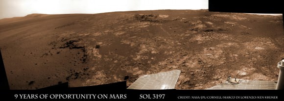
Opportunity rover discovered phyllosilicate clay minerals and calcium sulfate veins at the bright outcrops of ‘Whitewater Lake’, at right, imaged by the Navcam camera on Sol 3197 (Jan. 20, 2013, coinciding with her 9th anniversary on Mars. “Copper Cliff” is the dark outcrop, at top center. Darker “Kirkwood” outcrop, at left, is site of mysterious “newberries” concretions. This panoramic view was snapped from ‘Matijevic Hill’ on Cape York ridge at Endeavour Crater. Credit: NASA/JPL-Caltech/Cornell/Marco Di Lorenzo/Ken Kremer
Cape York is a hilly segment of the rim of Endeavour crater which spans 14 miles (22 km) across – where the robot arrived in mid-2011 and will spend her remaining life.
Opportunity has now set sail for her next crater rim destination named “Solander Point”, an area about 1.4 miles (2.2 kilometers) away – due south from “Cape York.”
“Our next destination will be Solander Point,” Squyres told Universe Today.
Along the way, Opportunity will soon cross “Botany Bay” and “Sutherland Point”, last seen when Opportunity first arrived at Cape York.
Eventually she will continue further south to a rim segment named ‘Cape Tribulation’ which holds huge caches of clay minerals.
The rover must arrive at “Solander Point” before the onset of her 6th Martian winter so that she can be advantageously tilted along north facing slopes to soak up the maximum amount of sun by her power generating solar wings. She might pull up around August.
On the other side of Mars, Opportunity’s new sister rover Curiosity also recently discovered clay minerals on the floor of her landing site inside Gale Crater.
Curiosity found the clay minerals – and a habitat that could support life – after analyzing powdery drill tailings from the Yellowknife Bay basin worksite with her on board state-of-the-art chemistry labs.
Just a week ago on May 15 (Sol 3309), Opportunity broke through the 40 year old American distance driving record set back in December 1972 by Apollo 17 astronauts Eugene Cernan and Harrison Schmitt.
But she is not sitting still resting on her laurels!
This past week the robots handlers’ back on Earth put the pedal to the metal and pushed her forward another quarter mile during 5 additional drives over 7 Sols, or Martian days. Thus her total odometry since landing on 24 January 2004 now stands at 22.45 miles (36.14 kilometers).
Opportunity will blast through the world record milestone of 23 miles (37 kilometers) held by the Lunokhod 2 lunar rover (from the Soviet Union), somewhere along the path to “Solander Point” in the coming months.
Opportunity captures the eerie Martian scenery looking south across Botany Bay from the southern tip of Cape York to her next destination – Solander Point, about 1 mile (1.6 km) away. This navcam photo mosaic was taken on Sol 3317, May 23, 2013. Credit: NASA/JPL/Cornell//Marco Di Lorenzo/Ken Kremer (kenkremer.com)
Endeavour Crater features terrain with older rocks than previously inspected and unlike anything studied before by Opportunity. It’s a place no one ever dared dream of reaching prior to Opportunity’s launch in the summer of 2003 and landing on the Meridiani Planum region in 2004.
Signatures of clay minerals, or phyllosilicates, were detected at several spots at Endeavour’s western rim by observations from the Compact Reconnaissance Imaging Spectrometer for Mars (CRISM) aboard NASA’s Mars Reconnaissance Orbiter (MRO).
“The motherlode of clay minerals is on Cape Tribulation. The exposure extends all the way to the top, mainly on the inboard side,” says Ray Arvidson, the rover’s deputy principal investigator at Washington University in St. Louis.
Stay tuned for the continuing breathtaking adventures of NASA’s sister rovers Opportunity and Curiosity!
And don’t forget to “Send Your Name to Mars” aboard NASA’s MAVEN orbiter- details here. Deadline: July 1, 2013
Traverse Map for NASA’s Opportunity rover from 2004 to 2013 to Record Setting Drive on May 15. This map shows the entire path the rover has driven during more than 9 years and over 3318 Sols, or Martian days, since landing inside Eagle Crater on Jan 24, 2004 to current location heading south to Solander Point from Cape York ridge at the western rim of Endeavour Crater. On May 15, 2013 Opportunity drove 263 feet (80 meters) southward – achieving a total traverse distance on Mars of 22.22 miles (35.76 kilometers) – and broke the driving record by any NASA vehicle that was previously held by the astronaut-driven Apollo 17 Lunar Rover in 1972. Credit: NASA/JPL/Cornell/ASU/Marco Di Lorenzo/Ken KremerOpportunity Heads Toward Next Destination, ‘Solander Point’ -This map of a portion of the western rim of Endeavour Crater on Mars shows the area where NASA’s Mars Exploration Rover Opportunity worked for 20 months, “Cape York,” in relation to the area where the rover team plans for Opportunity to spend its sixth Martian winter, “Solander Point.” Credit: NASA/JPL-Caltech/Univ. of Arizona
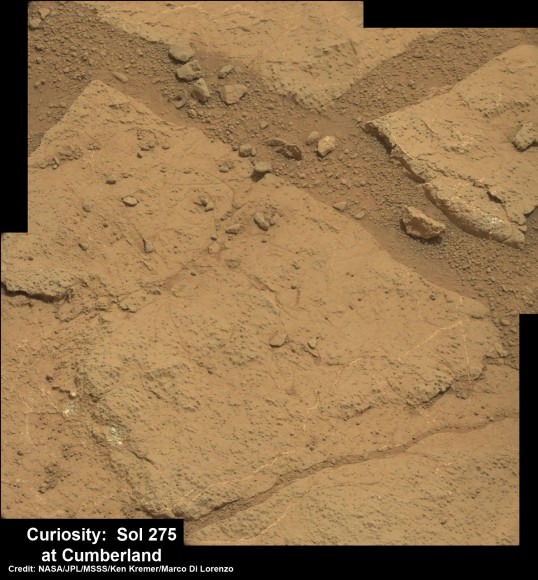
Panoramic view of Yellowknife Bay basin back dropped by Mount Sharp shows the location of the first two drill sites - John Klein & Cumberland - targeted by NASA’s Curiosity Mars rover. Curiosity accomplished historic 1st drilling into Martian rock at John Klein outcrop on Feb 8, 2013 (Sol 182) near where the robotic arm is touching the surface. This week the rover scooted about 9 feet to the right to Cumberland (right of center) for 2nd drill campaign in late-May 2013. Credit: NASA/JPL-Caltech/Ken Kremer/Marco Di Lorenzo
Video Caption: This JPL video shows the complicated choreography to get drill samples to Curiosity’s instruments as she prepares for 2nd drilling at “Cumberland.” See where “Cumberland” is located in our panoramic photo mosaic below.
It’s time at last for “Drill, Baby, Drill!” – Martian Style.
Well, check out this enlightening and cool new NASA video for an exquisitely detailed demonstration of just how Curiosity shakes, rattles and rolls on the Red Planet and swallows that mysterious Martian powder.
“Shake, shake, shake… shake that sample. See how I move drilled rock to analytical instruments,” tweeted Curiosity to millions of fans.
Get set to witness Martian gyrations like you’ve never seen before.
After a pair of short but swift moves this past week, NASA’s Curiosity rover is finally in position to bore into the Red Planet’s alien surface for the second time – at a target called “Cumberland.”
See where “Cumberland” is located in our panoramic photo mosaic below.
“Two short drives & 3.8 meters later, I’m zeroing in on my second Mars drilling target,” tweeted Curiosity.
Panoramic view of Yellowknife Bay basin back dropped by Mount Sharp shows the location of the first two drill sites – John Klein & Cumberland – targeted by NASA’s Curiosity Mars rover. Curiosity accomplished historic 1st drilling into Martian rock at John Klein outcrop on Feb 8, 2013 (Sol 182) near where the robotic arm is touching the surface. This week the rover scooted about 9 feet to the right to Cumberland (right of center) for 2nd drill campaign in late-May 2013.
Credit: NASA/JPL-Caltech/Ken Kremer/Marco Di Lorenzo [/caption]
These were Curiosity’s first drives since arriving at the “John Klein” outcrop in mid- January 2013 where she carried out the historic first ever interplanetary drilling by a robot on another world.
For the past few days the robot has snapped a series of close up images of “Cumberland” with the high resolution MAHLI camera on the “hand” of the dextrous robotic arm.
And now that Curiosity has switched to the B-side computer, the rover has switched over to an back up set of never before used cameras on the mast head, which appear to be functioning perfectly.
“Curiosity is now using the new pair of navigation cameras associated with the B-side computer,” said Curiosity science team member Kimberly Lichtenberg to Universe Today.
The rover also evaluated the potential drill site with the ChemCAM and APXS instruments to confirm whether ‘Cumberland’ is indeed a worthy target for the time consuming process to collect the drill tailings for delivery to the duo of miniaturized chemistry labs named SAM and Chemin inside her belly
As outlined in the video, the robot engages in an incredibly complex procedure to collect the drill bit tailings and then move and pulverize them through the chambers of the CHIMRA sample system on the tool turret for processing, filtering and delivery for in situ analysis that could take weeks to complete.
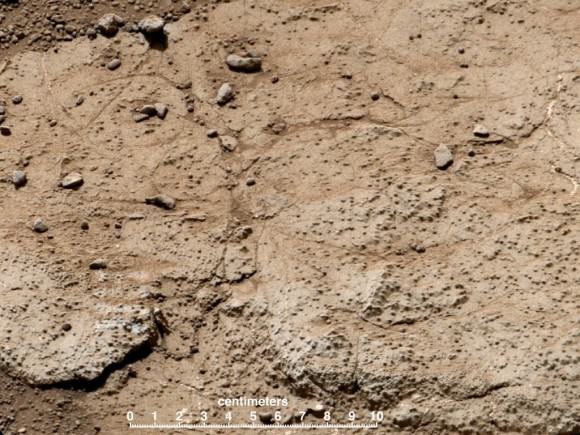
This patch of bedrock, called “Cumberland,” has been selected as the second target for drilling by NASA’s Mars rover Curiosity. The rover has the capability to collect powdered material from inside the target rock and analyze that powder with laboratory instruments. The favored location for drilling into Cumberland is in the lower right portion of the image. Credit: NASA/JPL-Caltech/MSSS
The state-of-the-art SAM and Chemin chemistry labs test aspirin sized quantities of the carefully sieved powder for the presence of organic molecules – the building blocks of life – and determine the inorganic chemical composition.
The science team wants to know how ‘Cumberland’ stacks up compared to ‘John Klein’, inside the shallow depression named ‘Yellowknife Bay’ where Curiosity has been exploring since late 2012.
“We’ll drill another hole to confirm what we found in the John Klein hole,” said John Grotzinger to Universe Today. Grotzinger, of the California Institute of Technology in Pasadena, Calif., leads NASA’s Curiosity Mars Science Laboratory mission.
‘Cumberland’ and ‘John Klein’ are patches of flat-lying bedrock shot through with pale colored hydrated mineral veins composed of calcium sulfate hydrated and a bumpy surface texture at her current location inside the ‘Yellowknife Bay’ basin that resembles a dried out lake bed.
“The bumpiness is due to erosion-resistant nodules within the rock, which have been identified as concretions resulting from the action of mineral-laden water,” according to NASA.
At Yellowknife Bay, Curiosity found evidence for an ancient habitable environment that could possibly have supported simple Martian microbial life forms eons ago when the Red Planet was warmer and wetter.
Analysis of the gray colored rocky Martian powder at ‘John Klein’ revealed that the fine-grained, sedimentary mudstone rock possesses significant amounts of phyllosilicate clay minerals; indicating the flow of nearly neutral liquid water and a habitat friendly to the possible origin of microbes.
Curiosity is expected to drill and swallow the ‘Cumberland’ powder at any moment if all goes well, a team member told Universe Today.
High resolution close-up of Cumberland outcrop on Sol 275 (May 15, 2013) – where Curiosity will bore her 2nd drill hole. Photo mosaic of Mastcam 100 raw images. Credit: NASA/JPL-Caltech/MSSS/Ken Kremer/Marco Di Lorenzo
Meanwhile as Curiosity was moving to Cumberland, her older sister Opportunity was blazing a trail at Endeavour Crater on the opposite side of Mars and breaking the distance driving record for an American space rover. Read all about it in my new story – here.
And don’t forget to “Send Your Name to Mars” aboard NASA’s MAVEN orbiter- details here. Deadline: July 1, 2013
…………….
Learn more about Mars, Curiosity, Opportunity, MAVEN, LADEE and NASA missions at Ken’s upcoming lecture presentations:
June 11: “Send your Name to Mars” and “LADEE Lunar & Antares Rocket Launches from Virginia”; NJ State Museum Planetarium and Amateur Astronomers Association of Princeton (AAAP), Trenton, NJ, 8 PM.
Opportunity pops a ‘wheelie’ on May 15, 2013 (Sol 3308) and then made history by driving further to the mountain ahead on the next day, May 16 (Sol 3309), to establish a new American driving record for a vehicle on another world. This navcam mosaic shows the view forward to Opportunity’s future destinations of Solander Point and Cape Tribulation along the lengthy rim of huge Endeavour crater spanning 14 miles (22 km) in diameter. Credit: NASA/JPL/Cornell/Kenneth Kremer/Marco Di Lorenzo.
Now more than 9 years and counting into her planned mere 90 day mission to Mars, NASA’s legendary Opportunity rover has smashed past another space milestone and established a new distance driving record for an American vehicle on another world this week.
On Thursday, May 16, the long-lived Opportunity drove another 263 feet (80 meters) on Mars – bringing her total odometry since landing on 24 January 2004 to 22.220 miles (35.760 kilometers) – and broke through the 40 year old driving record set back in December 1972 by Apollo 17 astronauts Eugene Cernan and Harrison Schmitt.
See below our complete map of the 9 Year Journey of Opportunity on Mars.
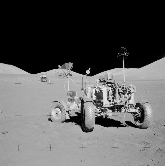
Cernan and Schmitt visited Earth’s moon on America’s final lunar landing mission and drove their mission’s Lunar Roving Vehicle (LRV-3) 22.210 miles (35.744 kilometers) over the course of three days on the moon’s surface at Taurus-Littrow.
Apollo 17 lunar rover at final resting place on the Moon. Lunar module in the background. Credit: NASA
Cernan was ecstatic at the prospect of the Apollo 17 record finally being surpassed.
“The record we established with a roving vehicle was made to be broken, and I’m excited and proud to be able to pass the torch to Opportunity, ” said Cernan to team member Jim Rice of NASA Goddard Space Flight Center, Greenbelt, Md, in a NASA statement.
And Opportunity still has plenty of juice left!
So, although there are no guarantees, one can reasonably expect the phenomenal Opportunity robot to easily eclipse the ‘Solar System World Record’ for driving distance on another world that is currently held by the Soviet Union’s remote-controlled Lunokhod 2 rover. See detailed graphic below.
In 1973, Lunokhod 2 traveled 23 miles (37 kilometers) on the surface of Earth’s nearest neighbor.
Why could Opportunity continue farther into record setting territory ?
Because Opportunity’s handlers back on Earth have dispatched the Martian robot on an epic trek to continue blazing a path forward around the eroded rim of the huge crater named ‘Endeavour’ – where she has been conducting ground breaking science since arriving at the “Cape York” rim segment in mid 2011.
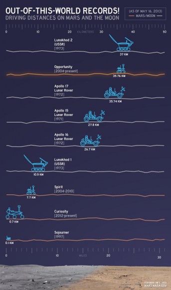
Out-of-this-World Records. This chart illustrates comparisons among the distances driven by various wheeled vehicles on the surface of Earth’s moon and Mars. Of the vehicles shown, the NASA Mars rovers Opportunity and Curiosity are still active and the totals for those two are distances driven as of May 15, 2013. Opportunity set the new NASA driving record on May 15, 2013 by traveling 22.220 miles (35.760 kilometers). The international record for driving distance on another world is still held by the Soviet Union’s remote-controlled Lunokhod 2 rover, which traveled 23 miles (37 kilometers) on the surface of Earth’s moon in 1973. Credit: NASA/JPL-Caltech
Opportunity has just now set sail for her next crater rim destination named “Solander Point”, an area about 1.4 miles (2.2 kilometers) away – due south from “Cape York.”
Endeavour Crater is 14 miles (22 km) wide, featuring terrain with older rocks than previously inspected and unlike anything studied before. It’s a place no one ever dared dream of reaching prior to Opportunity’s launch in the summer of 2003 and landing on the Meridiani Planum region in 2004.
Opportunity will blast through the world record milestone held by the Lunokhod 2 rover somewhere along the path to “Solander Point.”
Thereafter Opportunity will rack up ever more miles as the rover continues driving further south to a spot called “Cape Tribulation”, that is believed to hold caches of clay minerals that formed eons ego when liquid water flowed across this region of the Red Planet.
It’s a miracle that Opportunity has lasted so far beyond her design lifetime – 37 times longer than the 3 month “warranty.”
“Regarding achieving nine years, I never thought we’d achieve nine months!” Principal Investigator Prof. Steve Squyres of Cornell University told me recently on the occasion of the rovers 9th anniversary on Mars in January 2013.
“Our next destination will be Solander Point,” said Squyres.
Opportunity was joined on Mars by her younger sister Curiosity, currently exploring the crater floor inside Gale Crater since landing on Aug. 6, 2012.
Curiosity is likewise embarked on a epic trek – towards 3 mile high (5.5 km) Mount Sharp some 6 miles away.
Both rovers Opportunity & Curiosity have discovered phyllosilicates, hydrated calcium sulfate mineral veins and vast evidence for flowing liquid water on Mars. All this data enhances the prospects that Mars could have once supported microbial life forms.
The Quest for Life beyond Earth continues ably with NASA’s Martian sister rovers.
And don’t forget to “Send Your Name to Mars” aboard NASA’s MAVEN orbiter- details here. Deadline: July 1, 2013
Traverse Map for NASA’s Opportunity rover from 2004 to 2013 to Record Setting Drive on May 15. This map shows the entire path the rover has driven during more than 9 years and over 3309 Sols, or Martian days, since landing inside Eagle Crater on Jan 24, 2004 to current location heading south from Cape York ridge at the western rim of Endeavour Crater. On May 15, 2013 Opportunity drove 263 feet (80 meters) southward – achieving a total traverse distance on Mars of 22.22 miles (35.76 kilometers) – and broke the driving record by any NASA vehicle that was previously held by the astronaut-driven Apollo 17 Lunar Rover in 1972.
Credit: NASA/JPL/Cornell/ASU/Marco Di Lorenzo/Ken KremerView Back at Record-Setting Drive by Opportunity. On the 3,309th Martian day, or sol, of its mission on Mars (May 15, 2013) NASA’s Mars Exploration Rover Opportunity drove 263 feet (80 meters) southward along the western rim of Endeavour Crater. That drive put the total distance driven by Opportunity since the rover’s January 2004 landing on Mars at 22.220 miles (35.760 kilometers. This exceeded the distance record by any NASA vehicle, previously held by the astronaut-driven Apollo 17 Lunar Rover in 1972. Credit: NASA/JPL-CaltechSoviet Lunokhod-2 lunar rover. Credit: Ria Novosti