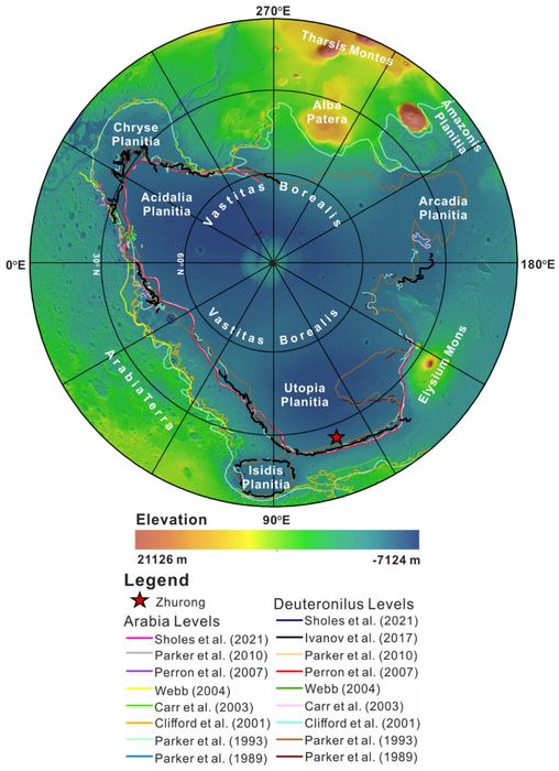
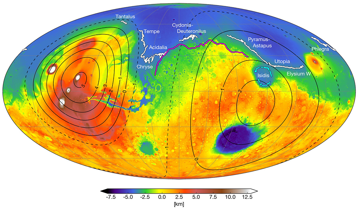
In a recent study published in National Science Review, a team of researchers led by the China University of Geosciences discuss direct evidence of an ancient ocean and its shoreline that existed in the northern hemisphere of Mars during the Hesperian Period, or more than 3 billion years ago. This finding is based on data collected by the China National Space Agency’s (CNSA) Zhurong rover in the Vastitas Borealis Formation (VBF), which lies within southern Utopia Planitia on Mars.
Artist's impression of Mars during the Noachian Era. Credit: Ittiz/Wikipedia Commons
Billions of years ago, Mars was a much different place than it is today. During the same period when life was first emerging on Earth, Mars had a thicker atmosphere, warmer surface temperatures, and flowing water on its surface. Evidence of this warmer, wetter past is preserved on the planet’s surface today in the form of river channels, lakebeds, alluvial fans, and sedimentary deposits. When this period began, and how long it lasted, remains the subject of much debate for scientists.
Knowing how long this period lasted helps establish how big the window of opportunity was for life on Mars. But according to new NASA-funded research from the Sellers Exoplanet Environments Collaboration (SEEC), Mars may have been wetter longer than previously expected. According to recently published results in the Proceedings of the National Academy of Sciences, Mars may have had a northern ocean as recent as three billion years ago.
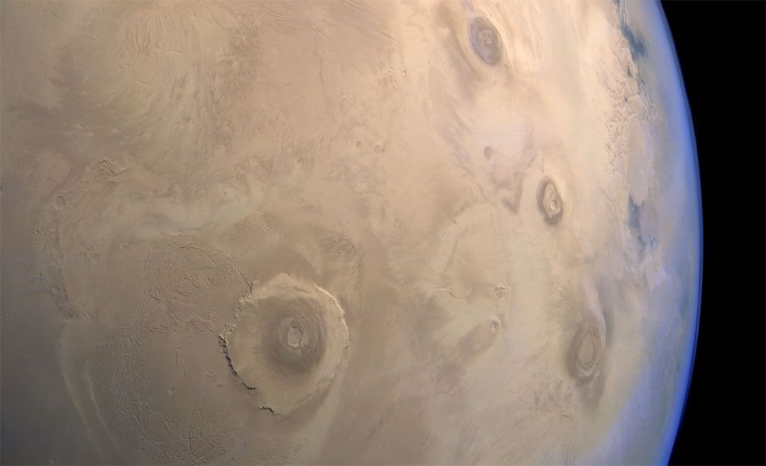
Image of the Tharsis region of Mars taken by Mars Express featuring several prominent shield volcanoes includes the massive Olympus Mons (at left). Credit: ESA
Thanks to the many missions that have been studying Mars in recent years, scientists are aware that roughly 4 billion years ago, the planet was a much different place. In addition to having a denser atmosphere, Mars was also a warmer and wetter place, with liquid water covering much of the planet’s surface. Unfortunately, as Mars lost its atmosphere over the course of hundreds of millions of years, these oceans gradually disappeared.
When and where these oceans formed has been the subject of much scientific inquiry and debate. According to a new study by a team of researchers from UC Berkeley, the existence of these oceans was linked to the rise of the Tharis volcanic system. They further theorize that these oceans formed several hundred millions years earlier than expected and were not as deep as previously thought.
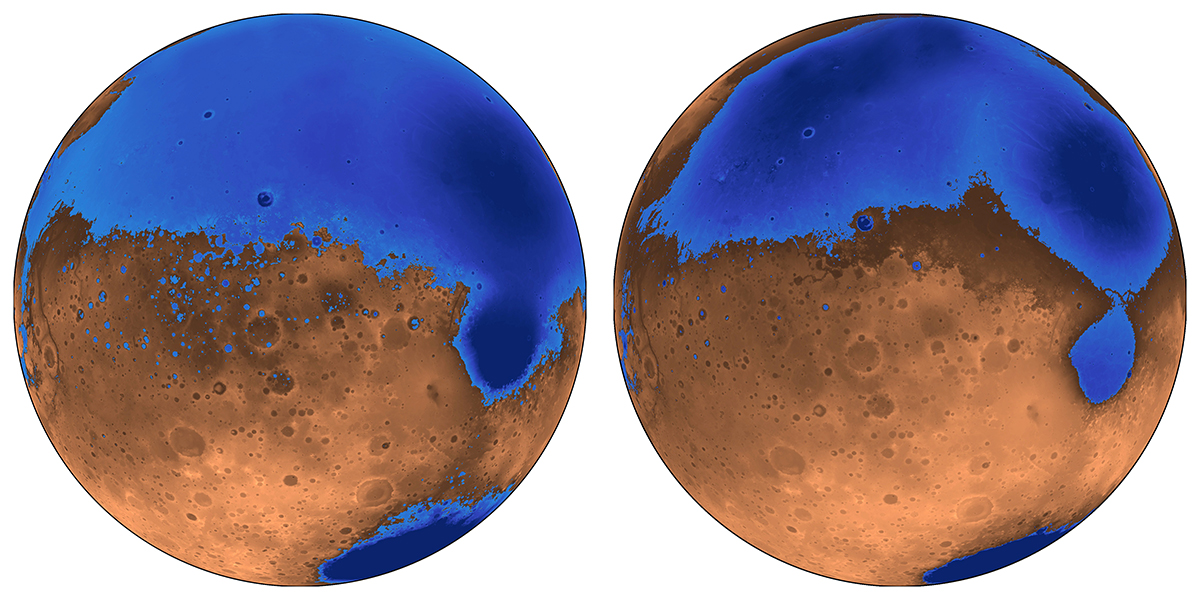
The early ocean known as Arabia (left, blue) would have looked like this when it formed 4 billion years ago on Mars, while the Deuteronilus ocean (right), about 3.6 billion years old, had a smaller shoreline. Credit: Robert Citron/UC Berkeley
As Michael Manga explained in a recent Berkeley News press release:
“The assumption was that Tharsis formed quickly and early, rather than gradually, and that the oceans came later. We’re saying that the oceans predate and accompany the lava outpourings that made Tharsis.”
The debate over the size and extent of Mars’ past oceans is due to some inconsistencies that have been observed. Essentially, when Mars lost its atmosphere, its surface water would have frozen to become underground permafrost or escaped into space. Those scientists who don’t believe Mars once had oceans point to the fact that the estimates of how much water could have been hidden away or lost is not consistent with estimates on the oceans’ sizes.
What’s more, the ice that is now concentrated in the polar caps is not enough to create an ocean. This means that either less water was present on Mars than previous estimates indicate, or that some other process was responsible for water loss. To resolve this, Citron and his colleagues created a new model of Mars where the oceans formed before or at the same time as Mars’ largest volcanic feature – Tharsis Montes, roughly 3.7 billion years ago.
A colorized image of the surface of Mars taken by the Mars Reconnaissance Orbiter. The line of three volcanoes is the Tharsis Montes, with Olympus Mons to the northwest. Valles Marineris is to the east. Image: NASA/JPL-Caltech/ Arizona State University
Since Tharsis was smaller at the time, it did not cause the same level of crustal deformation that it did later. This would have been especially true of the plains that cover most the northern hemisphere and are believed to have been an ancient seabed. Given that this region was not subject to the same geological change that would have come later, it would have been shallower and held about half the water.
“The assumption was that Tharsis formed quickly and early, rather than gradually, and that the oceans came later,” said Manga. “We’re saying that the oceans predate and accompany the lava outpourings that made Tharsis.”
In addition, the team also theorized that the volcanic activity that created Tharsis may have been responsible for the formation of Mars’ early oceans. Basically, the volcanoes would have spewed gases and volcanic ash into the atmosphere that would have led to a greenhouse effect. This would have warmed the surface to the point that liquid water could form, and also created underground channels that allowed water to reach the northern plains.
Their model also counters other previous assumptions about Mars, which are that its proposed shorelines are very irregular. Essentially, what is assumed to have been “water front” property on ancient Mars varies in height by as much as a kilometer; whereas on Earth, shorelines are level. This too can be explained by the growth of the Tharsis volcanic region, roughly 3.7 billion years ago.
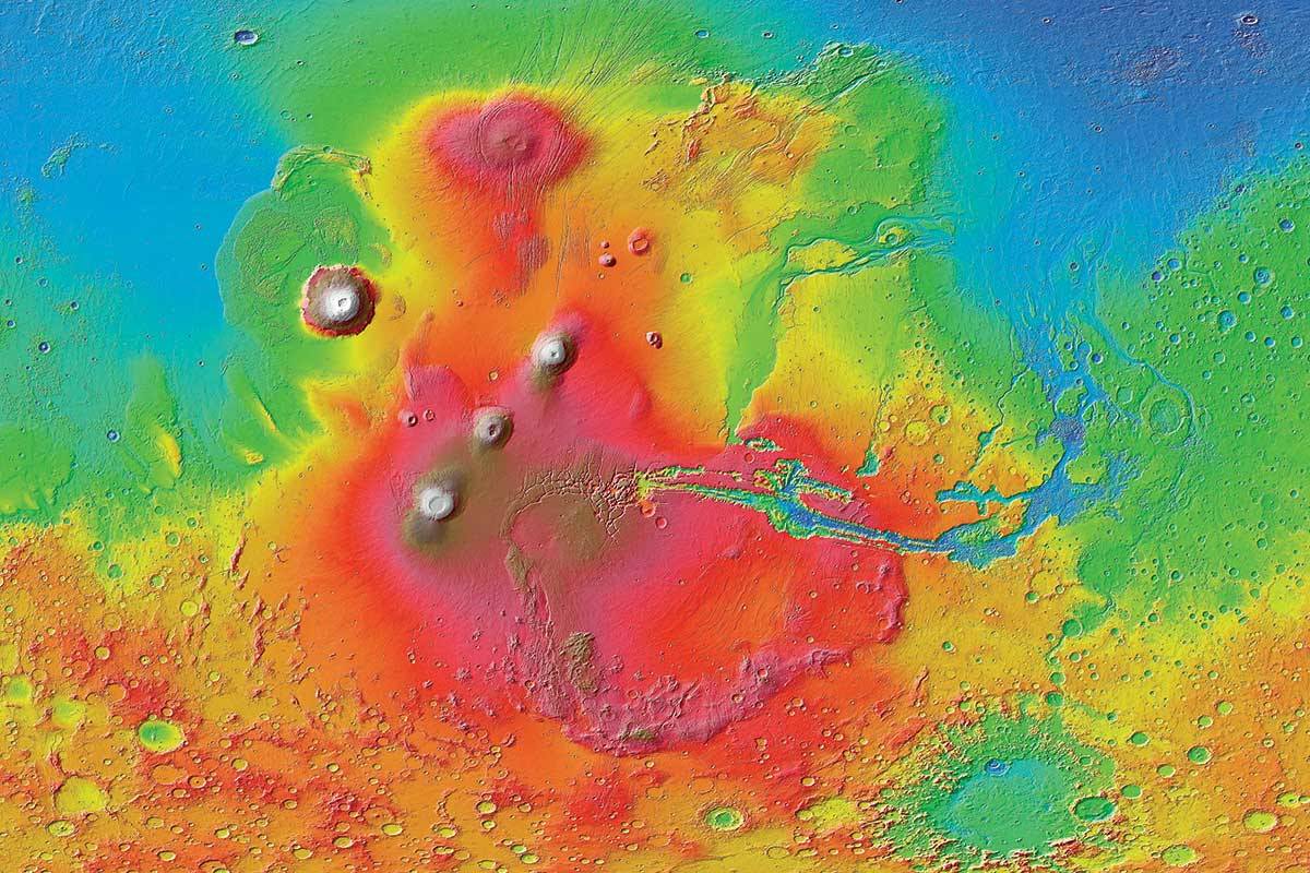
A map of Mars today shows where scientists have identified possible ancient shoreline that may have been etched by intermittent oceans billions of years ago. Credit: Robert Citron/UC Berkeley.
Using current geological data of Mars, the team was able to trace how the irregularities we see today could have formed over time. This would have began when Mars first ocean (Arabia) started forming 4 billion years ago and was around to witness the first 20% of Tharsis Montes growth. As the volcanoes grew, the land became depressed and the shoreline shifted over time.
Similarly, the irregular shorelines of a subsequent ocean (Deuteronilus) can be explained by this model by indicating that it formed during the last 17% of Tharsis’ growth – roughly 3.6 billion years ago. The Isidis feature, which appears to be an ancient lakebed slightly removed from the Utopia shoreline, could also be explained this way. As the ground deformed, Isidis ceased being part of the northern ocean and became a connected lakebed.
“These shorelines could have been emplaced by a large body of liquid water that existed before and during the emplacement of Tharsis, instead of afterwards,” said Citron. This is certainly consistent with the observable effect that Tharsis Mons has had on the topography of Mars. It’s bulk not only creates a bulge on the opposite side of the planet (the Elysium volcanic complex), but a massive canyon system in between (Valles Marineris).
This new theory not only explains why previous estimates about the volume of water in the northern plains were inaccurate, it can also account for the valley networks (cut by flowing water) that appeared around the same time. And in the coming years, this theory can be tested by the robotic missions NASA and other space agencies are sending to Mars.
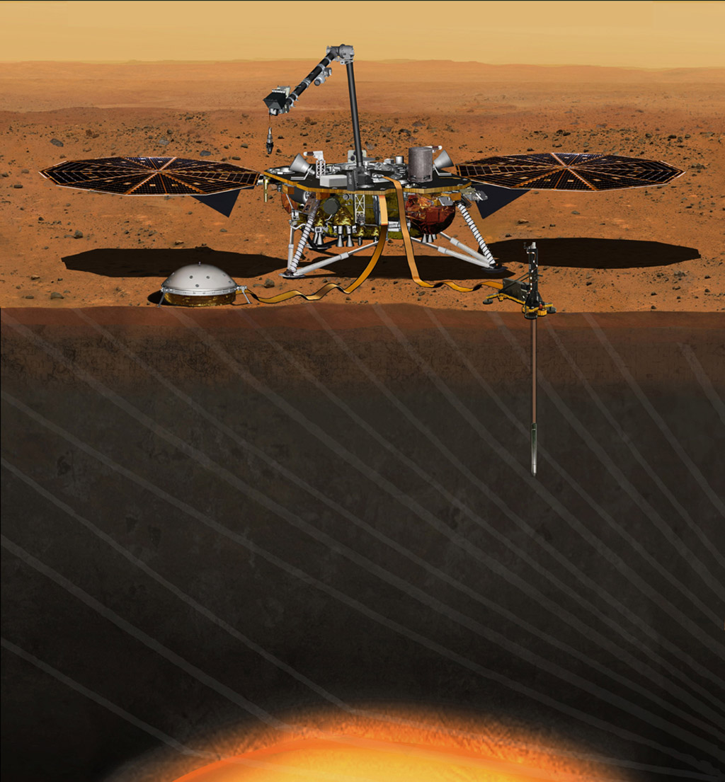
This artist’s concept from August 2015 depicts NASA’s InSight Mars lander fully deployed for studying the deep interior of Mars. Credit: NASA/JPL-Caltech
Consider NASA’s Interior Exploration using Seismic Investigations, Geodesy and Heat Transport (InSight) mission, which is scheduled for launch in May, 2018. Once it reaches Mars, this lander will use a suite of advanced instruments – which includes a seismometer, temperature probe and radio science instrument – to measure Mars interior and learn more about its geological activity and history.
Among other things, NASA anticipates that InSight might detect the remains of Mars’ ancient ocean frozen in the interior, and possibly even liquid water. Alongside the Mars 2020 rover, the ExoMars 2020, and eventual crewed missions, these efforts are expected to provide a more complete picture of Mars past, which will include when major geological events took place and how this could have affected the planet’s ocean and shorelines.
The more we learn about what happened on Mars over the past 4 billion years, the more we learn about the forces that shaped our Solar System. These studies also go a long way towards helping scientists determine how and where life-bearing conditions can form. This (we hope) will help us locate life it in another star system someday!
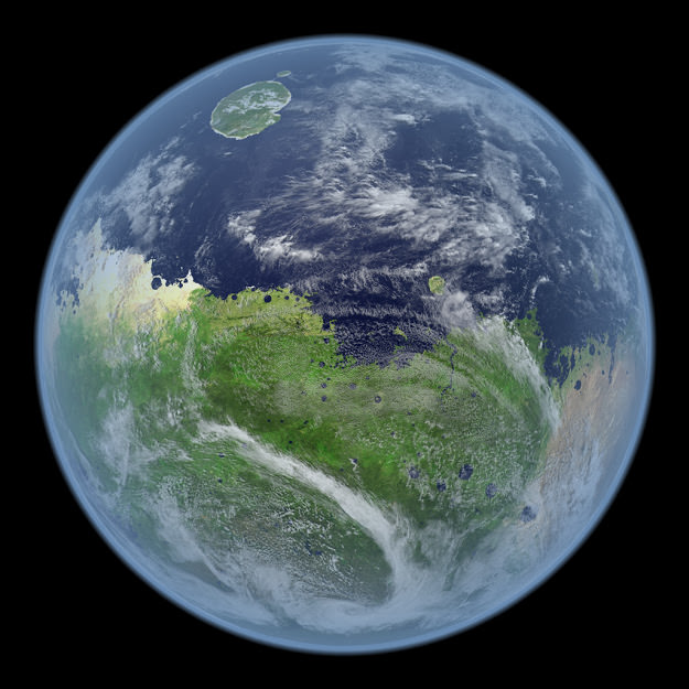
A conception of an ancient and/or future Mars, flush with oceans, clouds and life. Credit: Kevin Gill.
A conception of an ancient and/or future Mars, flush with oceans, clouds and life. Credit: Kevin Gill
Over the years, scientists have found evidence revealing that an ocean may have covered parts of the Red Planet billions of years ago. Others suggest that a future terraformed Mars could be lush with oceans and vegetation. In either scenario, what would Mars look like as a planet alive with water and life? By combining data from several sources — along with a bit of creative license — software engineer Kevin Gill has created some gorgeous images showing concepts of what a “living Mars” might look like from orbit, turning the Red Planet into its own version of the Blue Marble.
“This was something that I did both out of curiosity of what it would look like and to improve the software I was rendering this in,” Gill said via email. “I am a software engineer by trade and certainly no planetary scientist, so with the exception of any parts derived from actual data, most of it is assumptions I made based on simply comparing the Mars terrain to similar features here on Earth (e.g. elevation, proximity to bodies of water, physical features, geographical position, etc) and then using the corresponding textures from the Blue Marble images to paint the flat image layer in a graphics program.”
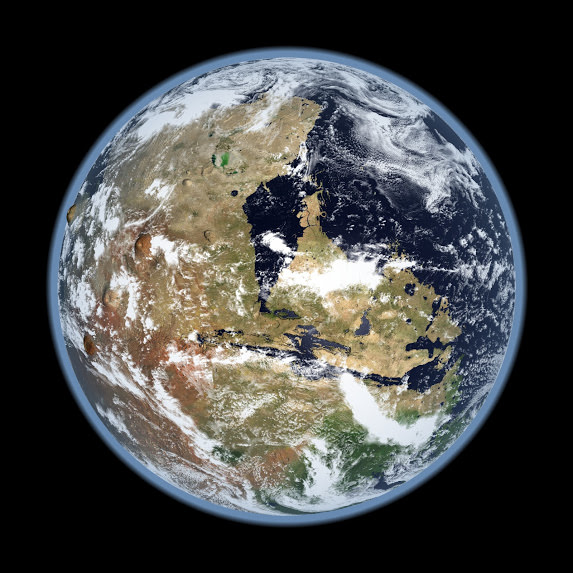
For example, the view below is of the western hemisphere of Mars, with Olympus Mons on the horizon beyond the Tharsis Montes volcanoes and the Valles Marineris canyons near the center. Gill said the height of the clouds and atmosphere are largely arbitrary and set for the sake of appearance. The terrain is also exaggerated by about 10 times. The orbital “eye” view is about 10,000 km (~6,200 miles) from the surface.
This is a conception view of the Western hemisphere of Mars with oceans and clouds. Olympus Mons is visible on the horizon beyond the Tharsis Montes volcanoes and the Valles Marineris canyons near the center. Credit: Kevin Gill
“This wasn’t intended as an exhaustive scientific scenario as I’m sure (and expect) some of my assumptions will prove incorrect,” Gill said on Google+. “I’m hoping at least to trigger the imagination, so please enjoy!”
He outlined his steps in creating the images:
A two dimensional digital elevation model was first rendered in jDem846 (an open-source learning project of mine) using the MRO MOLA 128 pix/deg elevation dataset. In that model, I picked a sea level and scripted it such that terrain at or below that level was flat and blue.
The resulting model was then brought into GIMP were I painted in land features using a NASA Blue Marble Next Generation image for the source textures. There is no scientific reasoning behind how I painted it; I tried to envision how the land would appear given certain features or the effects of likely atmospheric climate. For example, I didn’t see much green taking hold within the area of Olympus Mons and the surrounding volcanoes, both due to the volcanic activity and the proximity to the equator (thus a more tropical climate). For these desert-like areas I mostly used textures taken from the Sahara in Africa and some of Australia. Likewise, as the terrain gets higher or lower in latitude I added darker flora along with tundra and glacial ice. These northern and southern areas textures are largely taken from around northern Russia. Tropical and subtropical greens were based on the rainforests of South America and Africa.
Finally, that image was brought back into jDem846 as a layer to be reapplied to the same MOLA dataset, but rendered as a spherical projection (like Google Earth). I scripted the model to apply a three-dimensional cloud layer, add an atmosphere, and dampen specular lighting on dry land and under clouds. There are some other scripted tweaks here and there.
Gill has also done other visualizations of Mars and also the Moon, which can be seen on his G+ or Flickr page.