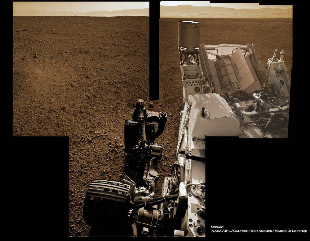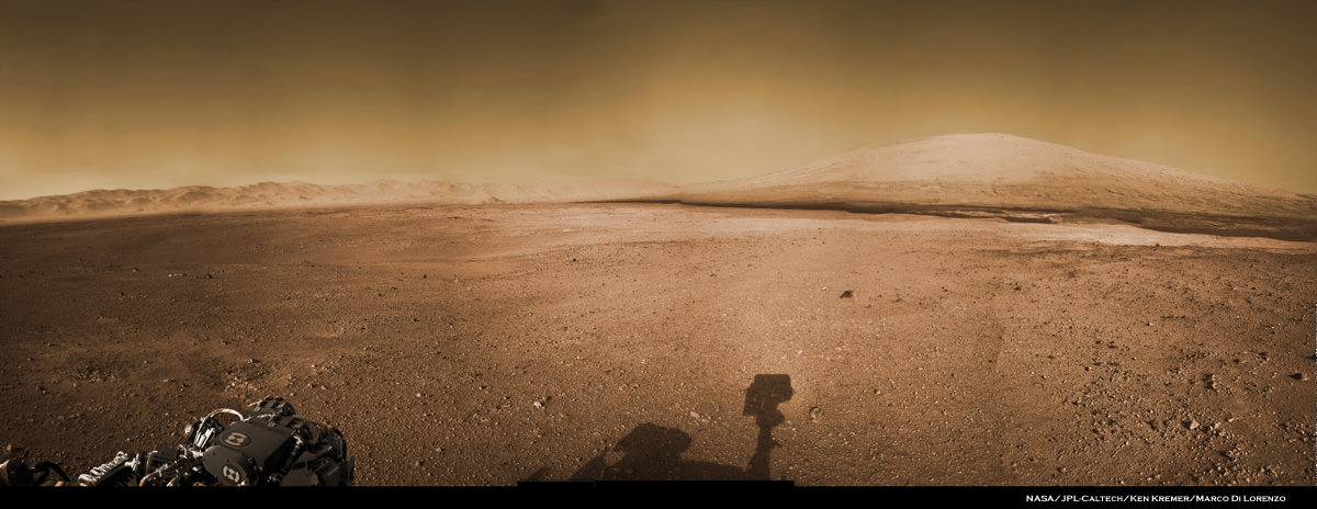
Image Caption: Panoramic Vista of Mount Sharp (at right) and Gale Crater from NASA’s Curiosity rover on Mars. Curiosity will eventually climb 3.4 mile high Mount Sharp in search of hydrated minerals. This colorized panoramic mosaic shows more than half of the landing site surrounding Curiosity in the distance to the visible peak of Mount Sharp and a portion of the stowed robotic arm (at left) and the shadow of the camera mast (center) in the foreground. The mosaic was assembled from new navigation camera (Navcam) images snapped by Curiosity on Sol 2 and Sol 12 and colorized based on Mastcam imagery from Curiosity. Image stitching and processing by Ken Kremer and Marco Di Lorenzo. See black and white version below. Credit: NASA/JPL-Caltech/Ken Kremer/Marco Di Lorenzo
At last the Curiosity mega rover is beaming back the first higher resolution panoramic images that many of us have longed to see – a complete view to the visible summit of towering Mount Sharp, the mountain she will scale, surrounded by the sweeping vistas of the tall eroded rim of Gale Crater, her touchdown site barely 2 weeks ago.
See our panoramic mosaics above and below incorporating the best available raw images to date. Curiosity’s stowed robotic arm and the shadow cast by the camera mast are visible in the foreground.
The new images from Curiosity’s mast mounted navigation cameras (Navcam) show the huge mountains peak to as far up as the rover can see from her vantage point some 7 kilometers (4 miles) from the base of the 18,000 foot (5.5 km) high Mount Sharp which is taller than Mount Rainier, the tallest peak in the contiguous United States.
By stitching together the newly received full resolution Navcam images from Sols 2 and 12, we (Ken Kremer and Marco Di Lorenzo) have created a panoramic mosaic showing the breathtaking expanse to the top of Mount Sharp combined with the perspective of Gale Crater from the rover’s eye view on the crater’s gravelly surface.

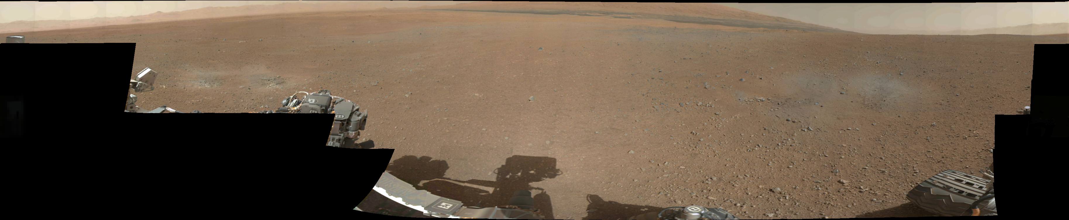
Image Caption: Panoramic Vista of Mount Sharp (at right) and Gale Crater from NASA’s Curiosity rover on Mars. Curiosity will eventually climb 3.4 mile high Mount Sharp in search of hydrated minerals. This panoramic mosaic shows more than half of the landing site surrounding Curiosity in the distance to the peak of Mount Sharp and a portion of the stowed robotic arm (at left) and the shadow of the camera mast (center) in the foreground. The mosaic was assembled from new navigation camera (Navcam) images snapped by Curiosity on Sol 2 and Sol 12. Image stitching and processing by Ken Kremer and Marco Di Lorenzo. Credit: NASA/JPL-Caltech/Ken Kremer/Marco Di Lorenzo – www.kenkremer.com
In coming weeks, Curiosity will take aim at Mount Sharp with the pair of high resolution Mastcam cameras (34 mm and 100) mounted on the rover’s mast and eventually provide much clearer images to the peak resulting in the most spectacular pictures imaginable of the mysterious mountain that holds the mother lode of hydrated mineral deposits that the robot was sent to investigate by NASA. So far the Mastcam cameras have only imaged the lower reaches of Mount Sharp.
The nuclear powered, car sized Curiosity rover was specifically engineered to accomplish a pinpoint landing inside the 96 mile (154 km) wide Gale Crater beside Mount Sharp so she could scale the mountain and take soil and rock samples of the clays and hydrated sulfated minerals that scientists believe formed in liquid water that flowed billions of years ago.
Mount Sharp is a gigantic mound that covers the entire central portion of Gale Crater and learning how it formed is one of the many mysteries researchers seek to unveil with the highly sophisticated 1 ton robot.
John Grotzinger, the project scientist for NASA’s Curiosity Mars Science Lab (MSL) rover, says that the hydrated minerals are all located in about the first 400 meters or so of Mount Sharp’s vertical elevation, based on spectral data collected by NASA and ESA spacecraft orbiting Mars. He says Curiosity will spend about a year traversing and investigating targets on the crater floor before reaching the foothills of Mount Sharp.
Curiosity will eventually spend years climbing Mount Sharp in the valleys between the 1 to 3 story tall mesas and buttes at the giant mountain’s base and lower elevations in search of sedimentary layers of the clay and hydrated sulfate mineral deposits.
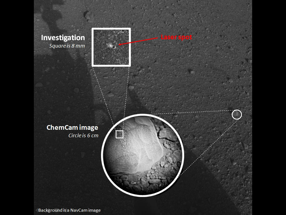
The powerful ChemCam laser that Curiosity successfully test fired today will be absolutely key to finding the best targets for detailed analysis by her 10 state of the art science instruments.
The mission goal is to ascertain whether the Red Planet was ever capable of supporting microbial life, past or present and to search for the signs of life in the form of organic molecules during the 2 year primary mission phase.

Image Caption: Gale Crater and Mount Sharp from orbit with Curiosity landing site ellipse