Image taken by NOAA's GOES East satellite at 12:45 p.m. EDT on July 15, 2013. (NOAA/NASA GOES Project)
Hot enough for ya? If you live anywhere on the eastern half of the United States (like me) you’ve probably been sweating it out over the past several days in what certainly feels like the warmest week yet for the season. The cause of the oppressive weather? A large mid-level ridge centered over the Ohio Valley — large enough to be easily visible from space.
The image above was taken by the GOES East satellite at 12:45 p.m. EDT on July 15. The clear area over Ohio shows the center of the system, which has been driving temperatures up into the 90s for much of the eastern U.S. and is expected to expand into the plains by mid-week. Along with increased humidity, heat index values will exceed 100 ºF and even approach 110 ºF on Friday.
A very anomalous weather pattern is in place over the U.S. for mid-July. Trapped between an upper level ridge centered over the Ohio Valley and the closed upper level low over the Texas/Oklahoma border, atypical hot, muggy air is stifling a broad swath of the eastern U.S. The closed low is expected to drift west toward New Mexico bringing heavy, localized rain to some areas and temperatures running 10-20 degrees below mid-July averages. Across the east, temperatures will warm well into the 90s and stay there through the week. (NOAA)
Rendering of a GOES satellite (NOAA)
As of the time of this writing heat advisories are in place in many parts of Michigan, southern Minnesota, and southern New England, and excessive heat warnings are active in eastern Pennsylvania and west central New Jersey. (Source)
Meanwhile, a closed low — seen above as a large, moisture-laden spiraling cloud system — is moving west across Texas and New Mexico, and is expected to bring lower-than-average temperatures along with heavy rains and flash flooding.
At an altitude of 22,336 miles, the geosynchronous GOES satellites continuously provide observations of 60 percent of the Earth including the continental United States, providing weather monitoring and forecast operations as well as a continuous and reliable stream of environmental information and severe weather warnings.
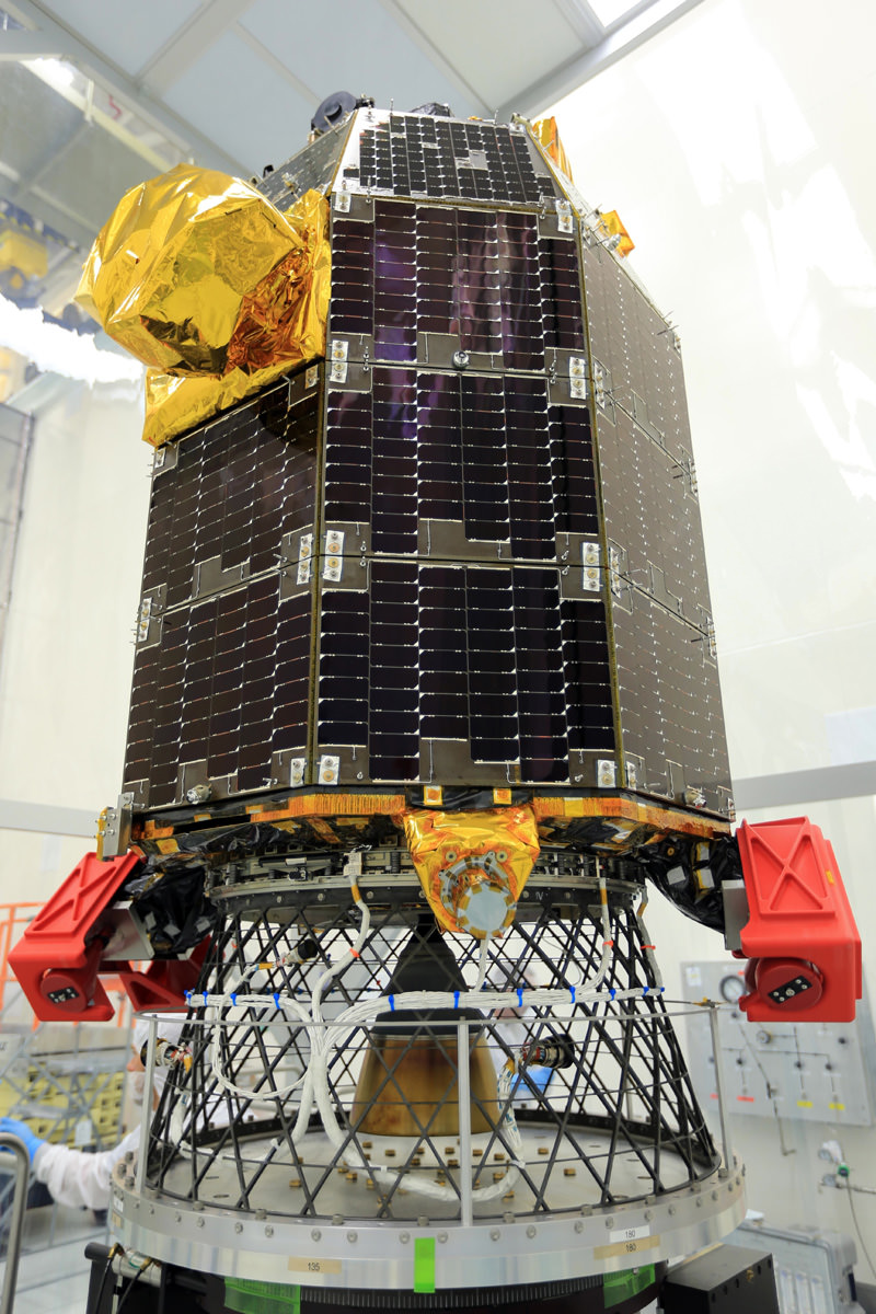
The LADEE spacecraft awaits spin balance testing, conducted to ensure stability during flight, at NASA’s Wallops Flight Facility in Virginia. LADEE is slated to liftoff from Wallops on Sep. 5, 2013 July 10. Credit: NASA/Patrick Black
NASA’s Lunar Atmosphere and Dust Environment Explorer (LADEE) Observatory has arrived at the launch site on the Eastern Shore of Virginia at NASA’s Wallops Flight Facility on Wallops Island and is now in the midst of weeks of performance testing to ensure it is ready for liftoff in early September.
The LADEE lunar orbiting probe will be the first planetary science mission ever launched from NASAWallops and the Mid-Atlantic Regional Spaceport (MARS). It will soar to space atop a solid fueled Minotaur V rocket on its maiden flight.
LADEE will blaze a brilliant trail to the Moon during a spectacular nighttime blastoff slated for Sept. 6, 2013 at 11:27 PM from Launch Pad 0B.
LADEE is equipped with three science instruments to gather detailed information about the lunar atmosphere, conditions near the surface and environmental influences on lunar dust.
“LADEE will investigate the moons tenuous exosphere, trace outgases like the sodium halo and lofted dust at the terminator,” said Jim Green, Planetary Science Division Director at NASA HQ, in an exclusive interview with Universe Today.
“The spacecraft has a mass spectrometer to identify the gases, a physical dust detector and an imager to look at scattered light from the dust. These processes also occur at asteroids.”
“And it will also test a laser communications system that is a technology demonstrator for future planetary science missions. It communicates at 650 megabits per second,” Green explained to me.
The couch sized 844 pound (383 kg) robotic explorer was assembled at NASA’s Ames Research Center, Moffett Field Calif., and is a cooperative project with NASA Goddard Spaceflight Center in Maryland.
The LADEE spacecraft awaits spin balance testing, conducted to ensure stability during flight, at NASA’s Wallops Flight Facility in Virginia. LADEE is slated to liftoff from Wallops on Sept. 6, 2013. Credit: NASA/Patrick Black
The spacecraft was then shipped cross country by a dedicated truck inside a specially-designed shipping container – blanketed with protective nitrogen – which insulated the spacecraft from temperature, moisture, bumps in the road and more than a few crazy drivers.
The first leg of LADEE’s trip to the Moon took 5 days. The trans lunar leg will take 30 days.
It’s standard practice that whenever space probes are moved by ground transportation that they are accompanied by a caravan that includes a lead scout vehicle to ensure safe road conditions and followed by engineers monitoring the health and environmental storage conditions.
Technicians are now engaged in a lengthy series of performance tests to confirm that LADEE was not damaged during the road trip and that all spacecraft systems are functioning properly.
“One important preparation about to begin is spin-balancing LADEE,” says Butler Hine, LADEE Project Manager. “During this procedure, the spacecraft is mounted to a spin table and rotated at a high-speed to make sure it is perfectly balanced for launch.”
After all spacecraft systems pass the performance tests, LADEE will be fueled, encapsulated and moved to the Wallops Island launch pad later this summer for mating with the five stage Minotaur V booster stack.
“I’m excited about the night launch because people up and down the Atlantic seacoast will be able to see it,” Green told me.
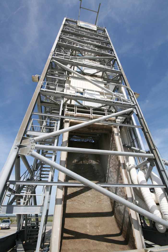
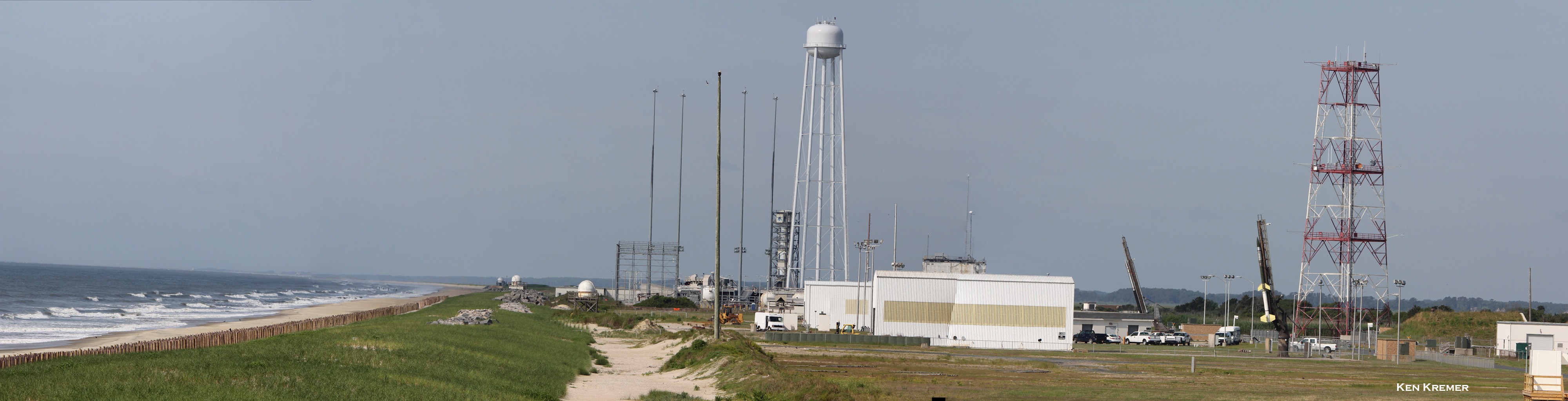
Looking up the Flame Trench –
LADEE Launch Pad 0B at NASA Wallops Flight Facility in Virginia. Credit: Ken Kremer/kenkremer.comAerial view of NASA Wallops launch site on Virginia shore shows launch pads for both suborbital and orbital rockets. The Antares rocket Pad 0A for missions to the ISS is in the foreground. Suborbital rockets blast off just behind the Pad 0A water tower. This photo was snapped from on top of Pad 0B that will soon launch NASA‘s LADEE orbiter to the Moon. Credit: Ken Kremer- kenkremer.com
ALMA/Spitzer image of a monster star in the process of forming
Even though it comprises over 99% of the mass of the Solar System (with Jupiter taking up most of the rest) our Sun is, in terms of the entire Milky Way, a fairly average star. There are lots of less massive stars than the Sun out there in the galaxy, as well as some real stellar monsters… and based on new observations from the Atacama Large Millimeter/submillimeter Array, there’s about to be one more.
Early science observations with ALMA have provided astronomers with the best view yet of a monster star in the process of forming within a dark cloud of dust and gas. Located 11,000 light-years away, Spitzer Dark Cloud 335.579-0.292 is a stellar womb containing over 500 times the mass of the Sun — and it’s still growing. Inside this cloud is an embryonic star hungrily feeding on inwardly-flowing material, and when it’s born it’s expected to be at least 100 times the mass of our Sun… a true stellar monster.
The location of SDC 335.579-0.292 in the southern constellation of Norma (ESO, IAU and Sky & Telescope)
The star-forming region is the largest ever found in our galaxy.
“The remarkable observations from ALMA allowed us to get the first really in-depth look at what was going on within this cloud,” said Nicolas Peretto of CEA/AIM Paris-Saclay, France, and Cardiff University, UK. “We wanted to see how monster stars form and grow, and we certainly achieved our aim! One of the sources we have found is an absolute giant — the largest protostellar core ever spotted in the Milky Way.”
SDC 335.579-0.292 had already been identified with NASA’s Spitzer and ESA’s Herschel space telescopes, but it took the unique sensitivity of ALMA to observe in detail both the amount of dust present and the motion of the gas within the dark cloud, revealing the massive embryonic star inside.
“Not only are these stars rare, but their birth is extremely rapid and their childhood is short, so finding such a massive object so early in its evolution is a spectacular result.”
– Team member Gary Fuller, University of Manchester, UK
The image above, a combination of data acquired by both Spitzer and ALMA (see below for separate images) shows tendrils of infalling material flowing toward a bright center where the huge protostar is located. These observations show how such massive stars form — through a steady collapse of the entire cloud, rather than through fragmented clustering.
SDC 335.579-0.292 seen in different wavelengths of light.
“Even though we already believed that the region was a good candidate for being a massive star-forming cloud, we were not expecting to find such a massive embryonic star at its center,” said Peretto. “This object is expected to form a star that is up to 100 times more massive than the Sun. Only about one in ten thousand of all the stars in the Milky Way reach that kind of mass!”
(Although, with at least 200 billion stars in the galaxy, that means there are still 20 million such giants roaming around out there!)
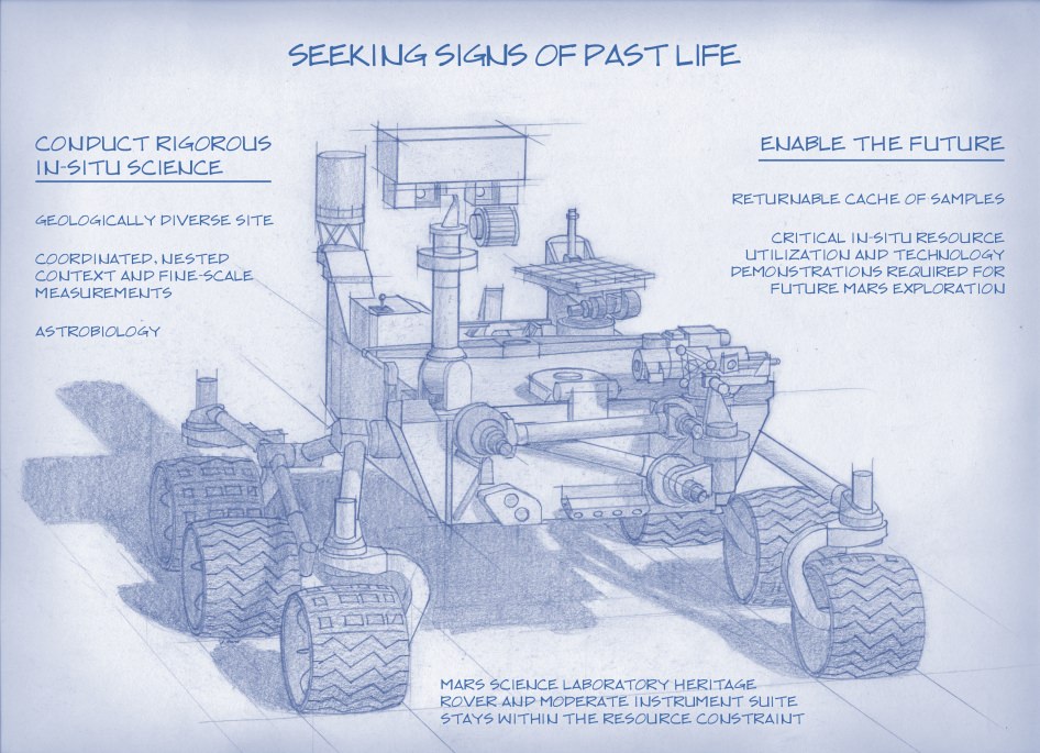
Artist's Concept of NASA’s Mars 2020 Rover envisions a basic structure that capitalizes on re-using the design and engineering work done for the NASA rover Curiosity, which landed on Mars in 2012, but with new science instruments for accomplishing different science objectives with the 2020 mission. Credit: NASA/JPL-Caltech
NASA’s next Mars rover set for liftoff in 2020 should focus on three primary objectives; seeking signs of past life, collecting a cache of carefully chosen samples for eventual return to Earth and developing technologies that will help enable future human missions to the Red Planet some two decades from now.
The 2020 goals were laid out publicly today (July 9) by a panel of scientists on the ‘Science Definition Team’ and charged by NASA with defining the key science objectives for the new mission.
The science objectives and how to accomplish them are outlined in considerable detail in a newly issued 154 page report handed over to the space agency and discussed at today’s NASA briefing for the media.
Looking for signs of ancient life and preserved biosignatures on Mars at a place that was once habitable is the top priority of the 2020 mission. The SDT report states that the landing site should be chosen specifically to “explore the geology of a once habitable site.”
“We need a highly mobile rover that can make ‘in situ’ science measurements,” said Jack Mustard, chairman of the Science Definition Team and a professor at the Geological Sciences at Brown University in Providence, R.I., at the briefing.
“The rover would use its own instruments on Mars for visual, mineralogical and chemical analysis down to a microscopic scale to identify candidate features that may have been formed by past life,” states the SDT report.
“We can’t do this now with Curiosity,” explained Mustard. “We need higher resolution.”
Looking for ‘extant’ life, that is life surviving on Mars today, would be a by-product of the search for organic molecules and preserved biosignatures of life – past or present.
The Mars 2020 ‘Science Definition Team’ (SDT) is comprised of 19 scientists and engineers from academia and industry. They were appointed by NASA in January 2013 to thoroughly and quickly evaluate a wide range of options to accomplish the highest priority planetary science objectives and achieve President Obama’s challenge to send humans to Mars in the 2030s.
Retrieving soil and rock samples from Mars for analysis back on Earth by research teams worldwide using all the most advanced analytical instruments available to humankind with unprecedented capability has been the ‘Holy Grail’ of Mars exploration for several decades.
But the enormous cost and technical complexity of a Mars Sample Return (MSR) mission has caused it to be repeatedly postponed.
Creating a Returnable Cache of Martian Samples is a major objective for NASA’s Mars 2020 rover. This prototype show hardware to cache samples of cores drilled from Martian rocks for possible future return to Earth. The 2020 rover would be to collect and package a carefully selected set of up to 31 samples in a cache that could be returned to Earth by a later mission. The capabilities of laboratories on Earth for detailed examination of cores drilled from Martian rocks would far exceed the capabilities of any set of instruments that could feasibly be flown to Mars. The exact hardware design for the 2020 mission is yet to be determined. For scale, the diameter of the core sample shown in the image is 0.4 inch (1 centimeter). Credit: NASA/JPL-Caltech
The 2020 rover will be designed to make real progress on sample return for the first time. It will be capable of coring into rocks and storing 31 highly compelling Martian samples for return by a follow on mission to the Red Planet.
“But the timing on actually returning those samples to Earth is yet to be determined,” said John Grunsfeld, NASA’s associate administrator for science in Washington.
Everything NASA does is budget driven and the fiscal climate is rather gloomy right now.
“Crafting the science and exploration goals is a crucial milestone in preparing for our next major Mars mission,” said John Grunsfeld, NASA’s associate administrator for science in Washington, in a statement.
Work on the new rover must begin soon in order to achieve the mandatory 2020 launch deadline. Launch opportunities to Mars only open every 26 months and delays could balloon the costs by several hundred million dollars.
“The objectives determined by NASA with the input from this team will become the basis later this year for soliciting proposals to provide instruments to be part of the science payload on this exciting step in Mars exploration,” adds Grunsfeld.
“The 2020 rover will take a major step in ‘seeking signs of life” said Jim Green, director of NASA’s Planetary Science Division in Washington, at the briefing. “NASA will issue a call for science instruments this fall.”
The new mission would build upon the demonstrated science accomplishments of earlier missions like Curiosity, Spirit, Opportunity and Phoenix while vastly advancing the capabilities of the robots research instruments.
“Here’s the bottom line. Questions drive science,” explained Lindy Elkins-Tanton, SDT member and director of the Carnegie Institution for Science’s Department of Terrestrial Magnetism, Washington.
“We should be seeking to answer the very biggest questions. And one of the very biggest questions for all of humankind is – ‘Are we alone?’ And that is the question we’re hoping to make really big advances with on with this Mars 2020 mission.”
Grunsfeld explained that NASA has budgeted “for a mission cost of $1.5 Billion plus the cost of the launcher.”
The 2020 rover chassis, with some modifications, will be based on the blueprints of the highly successful Curiosity rover to keep down the cost and minimize risks. But the science instruments will be completely new and updated.
NASA’s 1 ton Curiosity rover touched down nearly a year ago and has already discovered that the Red Planet has the chemical ingredients and environmental conditions for a habitable zone that could have supported living Martian microbes.
The next logical step is to look for the ancient signs of life that would be preserved in the rock record on Mars.
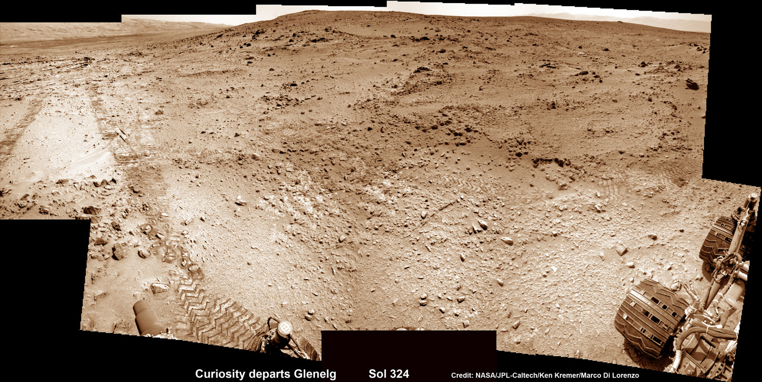
NASA’s 2020 Mars rover would be based on the Curiosity rover which touched down inside Gale Crater on Aug. 6, 2012 and discovered a habitable zone here. This photomosic shows NASA’s Curiosity departing Glenelg work site area at last for Mount Sharp- her main science destination, seen at top left. Note the wheel tracks on the Red Planet’s surface. The mosaic of navcam camera images was stitched from photos taken on July 4, 2013 (Sol 324). Credit: NASA/JPL-Caltech/Ken Kremer (kenkremer.com)/Marco Di Lorenzo
NASA Orion spacecraft blasts off atop 1st Space Launch System rocket in 2017 - attached to European provided service module – on an enhanced m mission to Deep Space where an asteroid could be relocated as early as 2021. Credit: NASA
NASA Orion spacecraft blasts off atop 1st Space Launch System rocket in 2017 – attached to European provided service module – on an ambitious mission to explore Deep Space some 40,000 miles beyond the Moon, where an asteroid could be relocated as early as 2021. Credit: NASA Story updated with further details[/caption]
NASA managers have announced a bold new plan to significantly alter and upgrade the goals and complexity of the 1st mission of the integrated Orion/Space Launch System (SLS) human exploration architecture – planned for blastoff in late 2017.
The ambitious first flight, called Exploration Mission 1 (EM-1), would be targeted to send an unpiloted Orion spacecraft to a point more than 40,000 miles (70,000 kilometers) beyond the Moon as a forerunner supporting NASA’s new Asteroid Redirect Initiative – recently approved by the Obama Administration.
The EM-1 flight will now serve as an elaborate harbinger to NASA’s likewise enhanced EM-2 mission, which would dispatch a crew of astronauts for up close investigation of a small Near Earth Asteroid relocated to the Moon’s vicinity.
Orion crew module separates from Space Launch System (SLS) upper stage. Credit: NASA
Until recently NASA’s plan had been to launch the first crewed Orion atop the 2nd SLS rocket in 2021 to a high orbit around the moon on the EM-2 mission, said NASA Associate Administrator Lori Garver in an prior interview with me at the Kennedy Space Center.
Concept of NASA spacecraft with Asteroid capture mechanism deployed to redirect a small space rock to a stable lunar orbit for later study by astronauts aboard Orion crew capsule. Credit: NASA.
The enhanced EM-1 flight would involve launching an unmanned Orion, fully integrated with the Block 1 SLS to a Deep Retrograde Orbit (DRO) near the moon, a stable orbit in the Earth-moon system where an asteroid could be moved to as early as 2021.
Orion’s mission duration would be nearly tripled to 25 days from the original 10 days.
“The EM-1 mission with include approximately nine days outbound, three to six days in deep retrograde orbit and nine days back,” Brandi Dean, NASA Johnson Space Center spokeswoman told Universe Today exclusively.
The proposed much more technologically difficult EM-1 mission would allow for an exceptionally more vigorous work out and evaluation of the design of all flight systems for both Orion and SLS before risking a flight with humans aboard.
Asteroid Capture in Progress
A slew of additional thruster firings would exercise the engines to change orbital parameters outbound, around the moon and inbound for reentry.
The current Deep Retrograde Orbit (DRO) plan includes several thruster firings from the Orion service module, including a powered lunar flyby, an insertion at DRO, an extraction maneuver from the DRO and a powered flyby on return to Earth.
Orion would be outfitted with sensors to collect a wide variety of measurements to evaluate its operation in the harsh space environment.
“EM-1 will have a compliment of both operational flight instrumentation and development flight instrumentation. This instrumentation suite gives us the ability to measure many attributes of system functionality and performance, including thermal, stress, displacement, acceleration, pressure and radiation,” Dean told me.
The EM-1 flight has many years of planning and development ahead and further revisions prior to the 2017 liftoff are likely.
“Final flight test objectives and the exact set of instrumentation required to meet those objectives is currently under development,” Dean explained.
Orion is NASA’s next generation manned space vehicle following the retirement of NASA’s trio of Space Shuttles in 2011.
The SLS launcher will be the most powerful and capable rocket ever built by humans – exceeding the liftoff thrust of the Apollo era Moon landing booster, the mighty Saturn V.
“We sent Apollo around the moon before we landed on it and tested the space shuttle’s landing performance before it ever returned from space.” said Dan Dumbacher, NASA’s deputy associate administrator for exploration systems development, in a statement.
“We’ve always planned for EM-1 to serve as the first test of SLS and Orion together and as a critical step in preparing for crewed flights. This change still gives us that opportunity and also gives us a chance to test operations planning ahead of our mission to a relocated asteroid.”
Both Orion and SLS are under active and accelerating development by NASA and its industrial partners.
The 1st Orion capsule is slated to blast off on the unpiloted EFT-1 test flight in September 2014 atop a Delta IV Heavy rocket on a two orbit test flight to an altitude of 3,600 miles above Earth’s surface.
Technicians work on mockups of the Orion crew capsule, Service Module and 6 ton Launch Abort System (LAS) to simulate critical assembly techniques inside the Vehicle Assembly Building (VAB) at NASA’s Kennedy Space Center (KSC) in Florida for the EFT-1 mission due to liftoff in September 2014. Credit: Ken Kremer/kenkremer.com
It will then reenter Earth’s atmosphere at speeds of about 20,000 MPH (11 km/sec) and endure temperatures of 4,000 degrees Fahrenheit in a critical test designed to evaluate the performance of Orion’s heatshield and numerous spacecraft systems.
Orion EFT-1 is already under construction at the Kennedy Space Center (KSC) by prime contractor Lockheed Martin – read my earlier story here.
Integration and stacking tests with Orion’s emergency Launch Abort System are also in progress at KSC – details here.
NASA says the SLS is also in the midst of a extensive review process called the Preliminary Design Review (PDR) to ensure that all launch vehicle components and systems will achieve the specified performance targets and be completed in time to meet the 2017 launch date. The PDR will be completed later this summer.
NASA’s goal with Orion/SLS is to send humans to the Moon and other Deep Space destinations like Asteroids and Mars for the first time in over forty years since the final manned lunar landing by Apollo 17 back in 1972.
NASA Headquarters will make a final decision on upgrading the EM-1 mission after extensive technical reviews this summer.
This photomosic shows NASA’s Curiosity departing at last for Mount Sharp- her main science destination. Note the wheel tracks on the Red Planet’s surface. The navcam camera images were taken on July 4, 2013 (Sol 324). Credit: NASA/JPL-Caltech/Ken Kremer (kenkremer.com)/Marco Di Lorenzo
NASA’s Curiosity rover has at last begun her epic trek to the layered slopes of mysterious Mount Sharp – the mission’s primary destination which looms supreme inside the Gale Crater landing site.
Scientists expect to discover signatures of the chemical ingredients that potentially are markers for a Martian habitable zone, while climbing up Mount Sharp.
On July 4 (Sol 324), the six wheeled robot started driving away from the Glenelg and Yellowknife Bay areas where she has worked more than half a year investigating the alien terrain and drilling into Martian rocks for the first time in history.
“We have started the long traverse to the base of Mt. Sharp (Aeolis Mons), the long-term goal of the mission!” announced science team member Ken Herkenhoff of the USGS.
So far the NASA rover already driven more than 190 feet (58 meters) over two excursions on July 4 and 7, away from her last science campaign at the Shaler outcrop of cross-bedded, sedimentary outcrops. Another drive is planned today.
Billions of years of Mars geologic history are preserved in the sedimentary layers of Mount Sharp- including the ancient time period when the Red Planet was far wetter and warmer than today, and thus more hospitable to the origin of life.
Billion-Pixel View From Curiosity at Rocknest, Raw Color. This full-circle view combined nearly 900 images taken by NASA’s Curiosity Mars rover, generating a panorama with 1.3 billion pixels in the full-resolution version. The view is centered toward the south, with north at both ends. It shows Curiosity at the “Rocknest” site where the rover scooped up samples of windblown dust and sand. Curiosity used three cameras to take the component images on several different days between Oct. 5 and Nov. 16, 2012. Credit: NASA/JPL-Caltech/MSSS
The huge mountain rises about 3.4 miles (5.5 km) from the center of Gale Crater. Its taller than Mount Ranier in Washington State.
The overland journey could take nearly a year or even longer into 2014 to arrive at the base of Mount Sharp, depending on what the 1 ton behemoth sees along the way.
And the scientists are eager to make as many discoveries as possible.
“The mission is discovery driven,” says John Grotznger of the California Institute of Technology in Pasadena, Calif., who leads NASA’s Curiosity Mars Science Laboratory mission. “We will go to where the science takes us.”
This is a cropped, reduced version of panorama from NASA’s Mars rover Curiosity with 1.3 billion pixels in the full-resolution version see full panorama above. It shows Curiosity at the “Rocknest” site where the rover scooped up samples of windblown dust and sand. Curiosity used three cameras to take the component images on several different days between Oct. 5 and Nov. 16, 2012. Viewers can explore this image with pan and zoom controls at http://mars.nasa.gov/bp1/. Credit: NASA/JPL-Caltech/MSSS
NASA chose Gale Crater as the landing site specifically to dispatch Curiosity to investigate the sedimentary layers of Mount Sharp because in surveys from Mars orbit it exhibited signatures of clay minerals that form in neutral water and that could possibly support the origin and evolution of simple Martian life forms, past or present.
“We have a real desire to get to Mount Sharp because there we see variations in the mineralogy as we go up from the base to higher levels and a change in the record of the environment,” explained Joy Crisp of JPL, Curiosity’s deputy project scientist.
“If we pass something amazing and compelling we might turn around and drive back,” Crisp added.
“The challenge for the science team will be to identify the most important targets along the way, and to study them without delaying drive progress too much,” notes Herkenoff.
Mount Sharp lies about 5 miles (8 kilometers) distant – as the Martian crow flies.
And Curiosity must also pass through a potentially treacherous dune field to get there.
“We are looking for the best path though,” said Curiosity Project Manager Jim Erickson of NASA’s Jet Propulsion Laboratory, Pasadena, Calif. at a recent media briefing.
Fisheye view of Mount Sharp from the hazcam camera on July 6, 2013 (Sol 326). Credit: NASA/JPL-Caltech
11 months ago on Aug. 6 , 2012, Curiosity made an unprecedented pinpoint touchdown inside Gale Crater using the never before used Sky crane descent thrusters.
Long before even arriving at destination Mount Sharp, Curiosity has already successfully accomplished the key science objective of the mission when she discovered that liquid water flowed at this spot on Mars, it possesses the key chemical ingredients required for life and was habitable in the past.
Drill samples from the ‘John Klein’ outcrop at Yellowknife Bay analyzed by Curiosity’s pair of onboard chemistry labs – SAM & Chemin – revealed that this location contains clay minerals required to support microbial life forms.
“We have found a habitable environment [at John Klein] which is so benign and supportive of life that probably if this water was around, and you had been on the planet, you would have been able to drink it,” said Grotzinger.
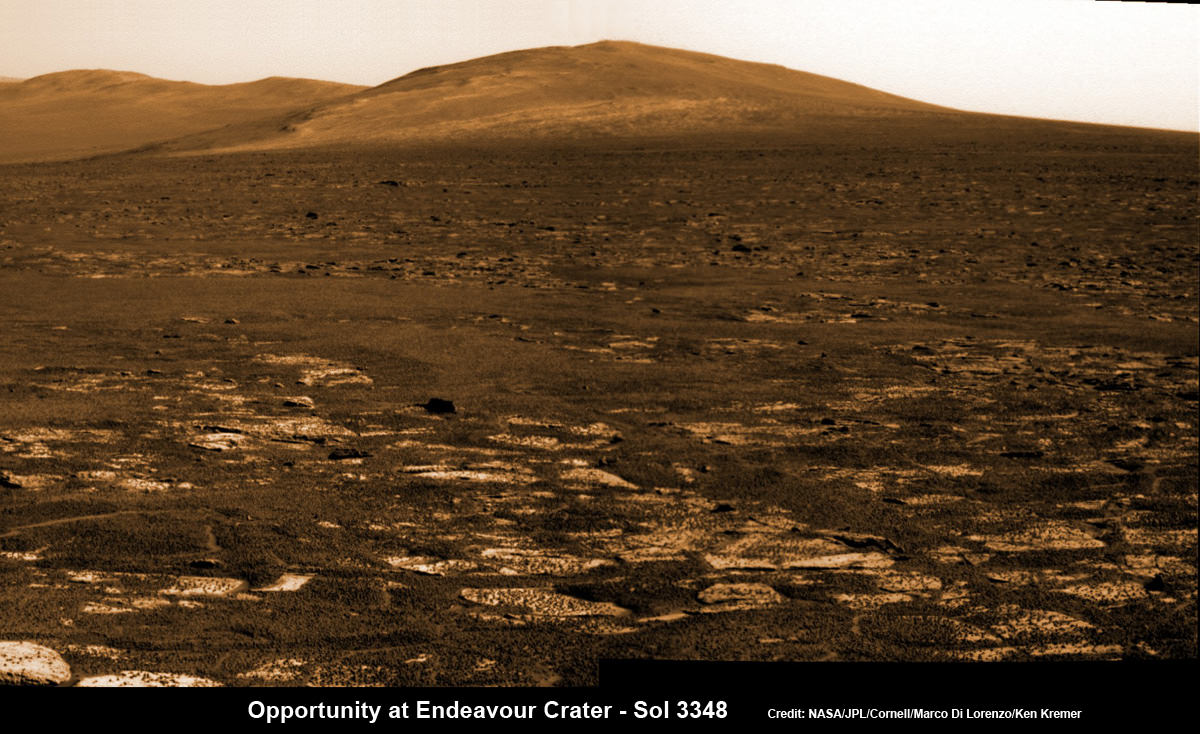
Opportunity rover’s view across Botany Bay to Solander Point - her next destination - as NASA celebrates 10 Years since blastoff for Mars on July 7, 2003. The rover will climb up Solander Point because it which may harbor clay minerals indicative of a past Martian habitable environment. This pancam mosaic was assembled from raw images taken on Sol 3348 (June 24, 2013. Credit: NASA/JPL/Cornell/ASU/Marco Di Lorenzo/Ken Kremer (kenkremer.com)
Opportunity rover’s view across Botany Bay to Solander Point – her next destination – as NASA celebrates 10 Years since blastoff for Mars on July 7, 2003. The rover will climb up Solander Point because it which may harbor clay minerals indicative of a past Martian habitable environment. This pancam mosaic was assembled from raw images taken on Sol 3348 (June 24, 2013.
Credit: NASA/JPL/Cornell/ASU/Marco Di Lorenzo/Ken Kremer (kenkremer.com)[/caption]
Today, NASA’sOpportunity rover marks a magical moment celebrating 10 years since launching to Mars on July 7, 2003 and with her impending Mountain destination filling the camera’s eye view.
The now legendary robot has vastly exceeded everyone’s expectations. Back in 2003 the science team promised us a mere 90 day ‘warranty’ following the suspenseful airbag landing on Jan. 24, 2004 at Meridiani Planum.
Today is Martian Day (or Sol) 3360. That amounts to a life expectancy and exploration ‘bonus’ of more than 37 times beyond the design lifetime.
Launch of NASA’s 2nd Mars Exploration Rover, Opportunity, aboard a Delta II Heavy rocket to Mars on July 7, 2003 at 11:18 p.m. EDT from Pad 17-B at Cape Canaveral Air Force Station, Fla. Credit: NASA
Opportunity’s twin sister Spirit blasted off three weeks earlier in June 2003 and continued functioning until 2010.
“I never thought we’d achieve nine months!” Principal Investigator Prof. Steve Squyres of Cornell University told me recently on the occasion of the rovers 9th anniversary on Mars in January 2013.
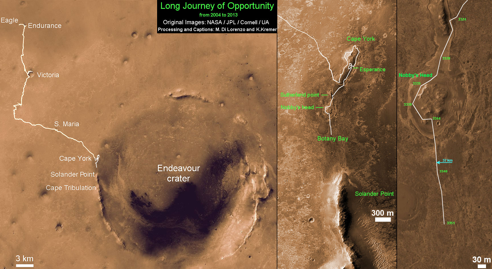
As you read this, the now decade old rover Opportunity is blazing a trail toward’s the oldest geological deposits she has ever explored – at a place called Solander Point, a raised ridge along the eroded rim of huge Endeavour Crater.
Opportunity has surpassed the halfway point in the traverse from the rim segment she has explored the past 22 months at ‘Cape York’ to her next rim segment destination at Solander.
From tip to tip, Cape York and Solander Point lie 1.2-mile (2-kilometer) apart along the western rim of Endeavour Crater. Both are raised portions of 14-mile-wide (22-kilometer-wide) Endeavour.
The rover has less than half a mile (800 meters) to go to finish the Martian dash from one rim segment to the next across an area called ‘Botany Bay’.
This view from July 2, 2013 (Sol 3355) shows the terrain that NASA’s Mars Exploration Rover Opportunity is crossing in a flat area called “Botany Bay” on the way toward “Solander Point,” which is visible on the horizon. Credit: NASA/JPL-Caltech
“We are making very good progress crossing ‘Botany Bay,’ said John Callas of NASA’s Jet Propulsion Laboratory, Pasadena, Calif., who is project manager for the mission now entering its 2nd decade.
The flat terrain of fractured, light-toned bedrock is devoid of treacherous dunes and is easy to drive across, almost like a highway, which simplifies the daily planning by the rovers Earthly handlers.
“The surface that Opportunity is driving across in Botany Bay is polygonally fractured outcrop that is remarkably good for driving,” said Brad Joliff, an Opportunity science team member and long-term planner at Washington University in St. Louis. “The plates of outcrop, like a tiled mosaic pavement, have a thin covering of soil, not enough to form the wind-blown ripples we’ve had to deal with during some other long treks. The outcrop plates are light-toned, and the cracks between them are filled with dark, basaltic soil and our old friends the ‘blueberries.”
The “blueberries” are hematite-rich, erosion-resistant concretions about the size of BB’s that Opportunity discovered when she first opened her eyes at her Eagle crater landing site. During the multi year crater hopping tour that ensued, the rover continued finding patches of blueberries all the way to Endeavour crater.
1st color panorama taken by Opportunity after landing inside Eagle Crater on Jan. 24, 2004. Credit: NASA/JPL/Cornell
Opportunity is expected to arrive at Solander’s foothills sometime in August – before the onset of the next southern hemisphere Martian winter, her 6th altogether.
Opportunity will scale Solander to continue the science quest in search of additional evidence of habitable environments with the chemical ingredients necessary to sustain Martian microbial life.
“Right now the rover team is discussing the best way to approach and drive up Solander,” Ray Arvidson told Universe Today. Arvidson is the mission’s deputy principal scientific investigator from Washington University in St. Louis, Mo.
‘Solander Point’ offers roughly about a 10 times taller stack of geological layering compared to ‘Cape York.’
Solander also offers north facing slopes where Opportunity’s solar wings can more effectively soak up the sun’s rays to generate life giving electrical power.
The robot remains in excellent health.
The total driving distance exceeds 23 miles (37 kilometers). She has snapped over 181,000 images.
Meanwhile on the opposite side of Mars at Gale Crater, Opportunity’s younger sister rover Curiosity also discovered a habitable environment originating from a time when the Red Planet was far warmer and wetter billions of years ago.
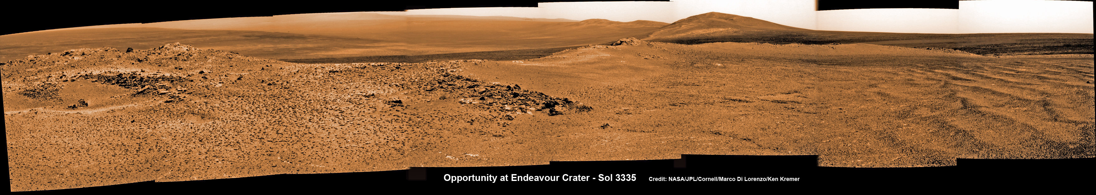
Opportunity captures spectacular panoramic view ahead to her upcoming mountain climbing goal, the raised rim of “Solander Point” at right, located along the western edge of Endeavour Crater. It may harbor clay minerals indicative of a habitable zone. The rise at left is “Nobbys Head” which the rover just passed on its southward drive to Solander Point from Cape York. This pancam photo mosaic was taken on Sol 3335, June 11, 2013 shows vast expanse of the central crater mound and distant Endeavour crater rim. Credit: NASA/JPL/Cornell/ASU/Marco Di Lorenzo/Ken Kremer (kenkremer.com) Traverse Map for NASA’s Opportunity rover from 2004 to 2013
This map shows the entire path the rover has driven during more than 9 years and over 3360 Sols, or Martian days, since landing inside Eagle Crater on Jan 24, 2004 to current location heading south to Solander Point from Cape York ridge at the western rim of Endeavour Crater. Credit: NASA/JPL/Cornell/ASU/Marco Di Lorenzo/Ken Kremer
If you’re like me, you don’t change your computer’s desktop background nearly often enough… especially not considering all the fantastic space images that get released on an almost daily basis. But this picture, shared a couple of weeks ago by NASA’s Marshall Space Flight Center on their Flickr stream, really should inspire you to fix that. (I know it did for me!)
Captured by an Expedition 28 crew member aboard the International Space Station, this beautiful image shows a crescent-lit Moon seen through the upper layers of Earth’s atmosphere.
As it circles the globe, the ISS travels an equivalent distance to the Moon and back in about a day, making an excellent platform for viewing the Earth and its atmosphere. This photo shows the limb of Earth near the bottom transitioning into the orange-colored troposphere, the lowest and most dense portion of the Earth’s atmosphere. The troposphere ends abruptly at the tropopause, which appears in the image as the sharp boundary between the orange- and blue- colored atmosphere. Silvery-blue noctilucent clouds extend far above the Earth’s troposphere.
Expedition 28 began on May 23, 2011, with a crew consisting of Andrey Borisenko, Ron Garan, Alexander Samokutyaev, Sergei Volkov, Mike Fossum, and Satoshi Furukawa.
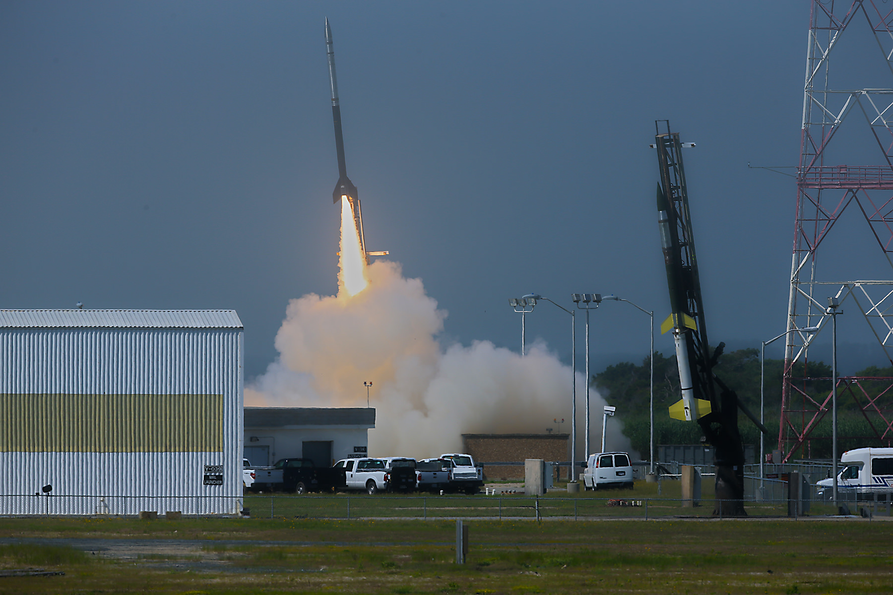
July 4 Morning Fireworks from NASA. A NASA Black Brant V Sounding Rocket launches in support of the Daytime Dynamo Mission on July 4, 2013 from NASA Wallops Flight Facility, VA, Credit NASA/J. Eggers
July 4 Morning Fireworks from NASA!
A NASA Black Brant V Sounding Rocket launches in support of the Daytime Dynamo Mission on July 4, 2013 from NASA Wallops Flight Facility, VA. Credit: NASA/J. Eggers[/caption]
WALLOPS ISLAND, VA – Today, July 4, NASA celebrated America’s Independence Day with a spectacular fireworks display of a dynamic duo of sounding rockets – blasting off barely 15 seconds apart this morning from the agencies NASA Wallops Island facility on the Eastern Shore of Virginia on a science experiment to study the ionosphere.
The goal of the two rocket salvo was an in depth investigation of the electrical currents in Earth’s ionosphere – called the Daytime Dynamo.
The Dynamo electrical current sweeps through the ionosphere, a layer of charged particles that extends from about 30 to 600 miles above Earth.
Disruptions in the ionosphere can scramble radio wave signals for critical communications and navigations transmissions that can impact our every day lives.
The launches suffered multiple delays over the past 2 weeks due to weather, winds, errant boats and unacceptable science conditions in the upper atmosphere.
A Black Brant V launches first in support of Daytime Dynamo. Terroer improved Orion (at right) followed 15 seconds later from NASA Wallops on July 4, 2013. Credit: NASA/P. Black
At last, the Fourth of July was the irresistible charm.
The liftoff times were 10:31:25 a.m. for the Black Brant V and 10:31:40 a.m. (EDT) for the Terrier-Improved Orion.
The experiment involved launching two suborbital rockets and also dispatching a NASA King Air airplane to collect a stream of airborne science measurements.
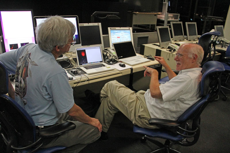
Daytime Dynamo is a joint project between NASA and the Japanese Space Agency, or Japan Aerospace Exploration Agency, or JAXA, said Robert Pfaff to Universe Today in an exclusive interview inside Mission Control at Wallops. Pfaff is the principle investigator for the Dynamo sounding rocket at NASA’s Goddard Space Flight Center in Greenbelt, Md.
“The dynamo changes during the day and varies with the season,” Pfaff told me.
But they only have one chance to launch. So the science team has to pick the best time to meet the science objectives.
“We would launch every month if we could and had the funding, in order to even more fully characterize the Dynamo.”
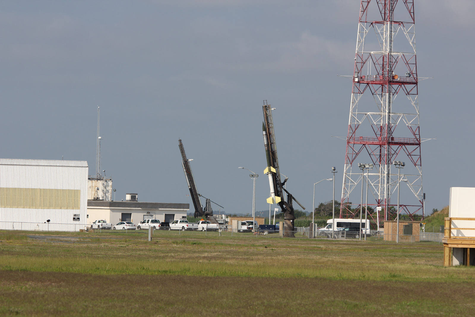
Two rocket salvo comprising a Black Brant V (left) and a Terrier-Improved Orion (right) sit ready to launch as part of the Daytime Dynamo mission in this panoramic view from NASA Wallops Flight Facility at Virginia’s Eastern Shore. Credit: Ken Kremer/kenkremer.com
The 35 foot tall single-stage Black Brant V launched first. It carried a 600 pound payload to collect the baseline data to characterize the neutral and charged ionospheric particles as it blasted skyward.
The 33 foot tall two-stage Terrier-Improved Orion took off just 15 seconds later in the wake of the exhaust of the Black Brant V.
Exhaust trails from Black Brant V and a Terrier-Improved Orion launched in support of Daytime Dynamo mission on July 4, 2013. Credit: NASA/P. Black
The Terrier-Improved Orion successfully deployed a lengthy trail of lithium gas from a pressurized canister that created a chemical tracer to track how the upper atmospheric winds vary with altitude. These winds are believed to be the drivers of the dynamo currents.
Both rockets fly for about five minutes to an altitude of some 100 miles up in the ionosphere. They both splashed down in the ocean after about 15 minutes.
NASA’s King Air aircraft was essential to the mission. I toured the airplane on the Wallops runway for an up-close look inside. It is outfitted with a bank of precisely aimed analytical instruments peering through the aircraft windows to capture the critical science data – see my photos herein.
“The King Air launches about an hour before the scheduled liftoff time,” Pfaff told me.
“It uses special cameras and filters to collect visible and infrared spectroscopic data from the lithium tracer to characterize the daytime dynamo.”
The science instruments are newly developed technology to make the daytime measurements of the lithium tracer and were jointly created by NASA, JAXA and scientists at Clemson University.
“Everything worked as planned,” Pfaff announced from Wallops Mission Control soon after the magnificent Fourth of July fireworks show this morning.
Black Brant V (left) and Terrier-Improved Orion (right) rockets sit on launch pads as part of the Daytime Dynamo mission in this up close view from NASA Wallops Flight Facility at Virginia’s Eastern Shore. Credit: Ken Kremer/kenkremer.comInside cabin view of NASA King Air aircraft outfitted with science instrument mounts to support a bank of cameras to capture visible and infrared spectroscopic measurements in support of Daytime Dynamic launches on July 4, 2013. Credit: Ken Kremer/kenkremer.comRobert Pfaff (right), Science Principle Investigator and Ken Kremer of Universe Today (left) discuss NASA’s Daytime Dynamo mission inside NASA Wallop’s Mission Control. Credit: Ken Kremer/kenkremer.com
Mars moon Phobos rising in the night time Martian sky shortly after sunset in this image from a movie taken by NASA's Mars rover Curiosity on Sol 317, June 28, 2013. The apparent ring is an imaging artifact The Credit: NASA/JPL-Caltech See the complete ‘Phobos Rising’ movie below
Mars moon Phobos (above, center) rising in the night time Martian sky shortly after sunset in this still image from a movie taken by NASA’s Mars rover Curiosity on Sol 317, June 28, 2013. The apparent ring is an imaging artifact. Credit: NASA/JPL-Caltech See the complete ‘Phobos Rising’ movie below [/caption]
Every once in a while when the time is just right and no one is looking, Curiosity’s Earthly handlers allow her some night time Martian delights.
In this case a pair of rising and setting celestial events bookend another magnificent week in humankinds exploration of the Red Planet – courtesy of NASA.
This past week NASA’s Curiosity rover captured esthetically stunning imagery of Phobos rising and Our Sun setting on Mars.
Phobos is the larger of Mars pair of tiny moons. The other being Diemos.
On June 28, (Sol 317) Curiosity aimed her navigation camera straight overhead to captured a breathtaking series of 86 images as Phobos was ascending in the alien evening sky shortly after sunset.
NASA combined these raw images taken over about 27 minutes into a short movie clip, sped up from real time.
Video Caption: ‘Phobos Rising’ – This movie clip shows Phobos, the larger of the two moons of Mars, passing overhead, as observed by NASA’s Mars rover Curiosity in a series of images centered straight overhead starting shortly after sunset. Phobos first appears near the lower center of the view and moves toward the top of the view. The images were taken on June 28, 2013. The apparent ring is an imaging artifact. Credit: NASA/JPL-Caltech
The pockmarked and potato shaped moon measures about 26.8 × 22.4 × 18.4 kilometers.
Phobos orbits barely some 6,000 km (3,700 mi) above the Martian surface. One day far in the future, it will crash and burn.
On June 22, Curiosity snapped an evocative series of Martian sunset photos as Sol set behind the eroded rim of Gale Crater – see below.
In the 2030’s, Humans may visit Phobos first before setting foot on the much more technically challenging Red Planet.
Sunset at Gale Crater
Martian sunset vista at Gale crater rim snapped by Curiosity on Sol 312, June 22, 2013. Colorized navcam image. Credit: NASA/JPL-Caltech/Ken Kremer/Marco Di LorenzoPhobos from NASA’s Mars Reconnaissance Orbiter on March 23, 2008. Credit: NASA