Yes, it's India, but it's not a photo captured from space during Diwali night. (Credit: NASA)
Diwali, the Indian festival of lights, falls on Thursday, Oct. 23 this year and with it come celebrations, gift-giving, and brilliant lighting and firework displays all across the subcontinent of India… but this isn’t a picture of that. What is it exactly? Find out below…
Over the past several years this image has repeatedly resurfaced online, especially around the time of Diwali. And understandably so: it’s a beautiful view of India seemingly decorated for the festival… one can easily imagine the entire country awash in colorful lights from shore to shore.
But it’s not a photo at all, or even a singular image. Rather it’s a composite of many images acquired from a USAF Defense Meteorological Satellite Program (DMSP) satellite over the course of several years, and assembled by NOAA scientist Chris Elvidge to show the country’s growing population and urban areas.
In a 2012 article by Robert Johnson on Business Insider a NASA spokesperson described the colors in the image: “The white lights were the only illumination visible before 1992. The blue lights appeared in 1992. The green lights in 1998. And the red lights appeared in 2003.”
So what does India look like at night during the five-day-long Diwali festival? Click here and see.
While city lighting in India is definitely visible from space, it’s not the rainbow explosion of neon colors that Internet hoaxers and uninformed online enthusiasts would eagerly have you believe. According to Adam Voiland on the NASA Earth Observatory site, “in reality, any extra light produced during Diwali is so subtle that it is likely imperceptible when observed from space.”
So this year, don’t fall for any false descriptions of this picture… and, Happy Diwali!
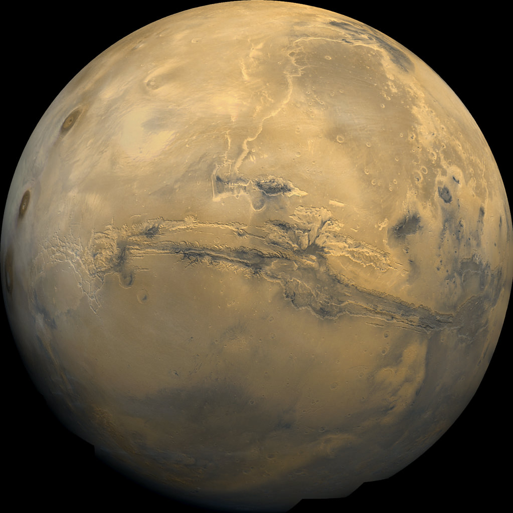
Olympus Mons, Tharsis Bulge trio of volcanoes and Valles Marineris from ISRO's Mars Orbiter Mission. Note the clouds and south polar ice cap. Credit: ISRO
India’s Mars Orbiter Mission (MOM) has delivered another sweet treat – a stunning view of our Solar System’s largest volcano and the largest canyon.
Just days ago, MOM captured a new global image of the Red Planet dominated by Olympus Mons and Valles Marineris – which is the largest known volcano and the largest known canyon in the Solar System, respectively.
Situated right in between lies a vast volcanic plateau holding a trio of huge volcanoes comprising the Tharsis Bulge: Arsia Mons, Pavonis Mons, and Ascraeus Mons. All four volcanoes are shield volcanoes.
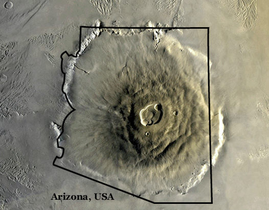
To give an idea of its enormity, Olympus Mons stands about three times taller than Mount Everest and is about the size of Arizona.
Olympus Mons from Mars orbit compared to the state of Arizona. Credit: NASA
Olympus Mons is located in Mars’ western hemisphere and measures 624 kilometers (374 miles) in diameter, 25 km (16 mi) high, and is rimmed by a 6 km (4 mi) high scarp.
Valles Marineris is often called the “Grand Canyon of Mars.” It spans about as wide as the entire United States.
The Indian Space Research Organization (ISRO), India’s space agency which designed and developed the orbiter released the image on Oct. 17, barely two days ahead of the planet’s and spacecrafts’ extremely close encounter with comet Siding Spring.
By the way, a relieved ISRO tweeted MOM’s survival of her close shave with the once-in-a-lifetime cometary passage with gusto, soon after the swingby:
“Phew! Experience of a lifetime. Watched the #MarsComet #SidingSpring whizzing past the planet. I’m in my orbit, safe and sound.”
The new global image was taken by the tri-color camera as MOM swooped around the Red Planet in a highly elliptical orbit whose nearest point to Mars (periapsis) is at 421.7 km and farthest point (apoapsis) at 76,993.6 km, according to ISRO.
To date ISRO has released four global images of the Red Planet, including a 3-D view, reported here.
Olympus Mons, the Tharsis Bulge, and Valles Marineris are near the equator.
Valles Marineris stretches over 4,000 km (2,500 mi) across the Red Planet, is as much as 600 km wide, and measures as much as 7 kilometers (4 mi) deep.
Here’s a comparison view of the region taken by NASA’s Viking 1 orbiter in the 1970s.
Global Mosaic of Mars Centered on Valles Marineris from NASA’s Viking 1 orbiter. Credit: NASA
MOM is India’s first deep space voyager to explore beyond the confines of her home planet’s influence and successfully arrived at the Red Planet only one month ago after the “history creating” orbital insertion maneuver on Sept. 23/24 following a ten month journey.
The $73 million MOM mission is expected to last at least six months.
MOM’s success follows closely on the heels of NASA’s MAVEN orbiter which also successfully achieved orbit barely two days earlier on Sept. 21 and could last 10 years or more.
With MOM’s arrival, India became the newest member of an elite club of only four entities that have launched probes that successfully investigated Mars – following the Soviet Union, the United States, and the European Space Agency (ESA).
Stay tuned here for Ken’s continuing Earth and planetary science and human spaceflight news.
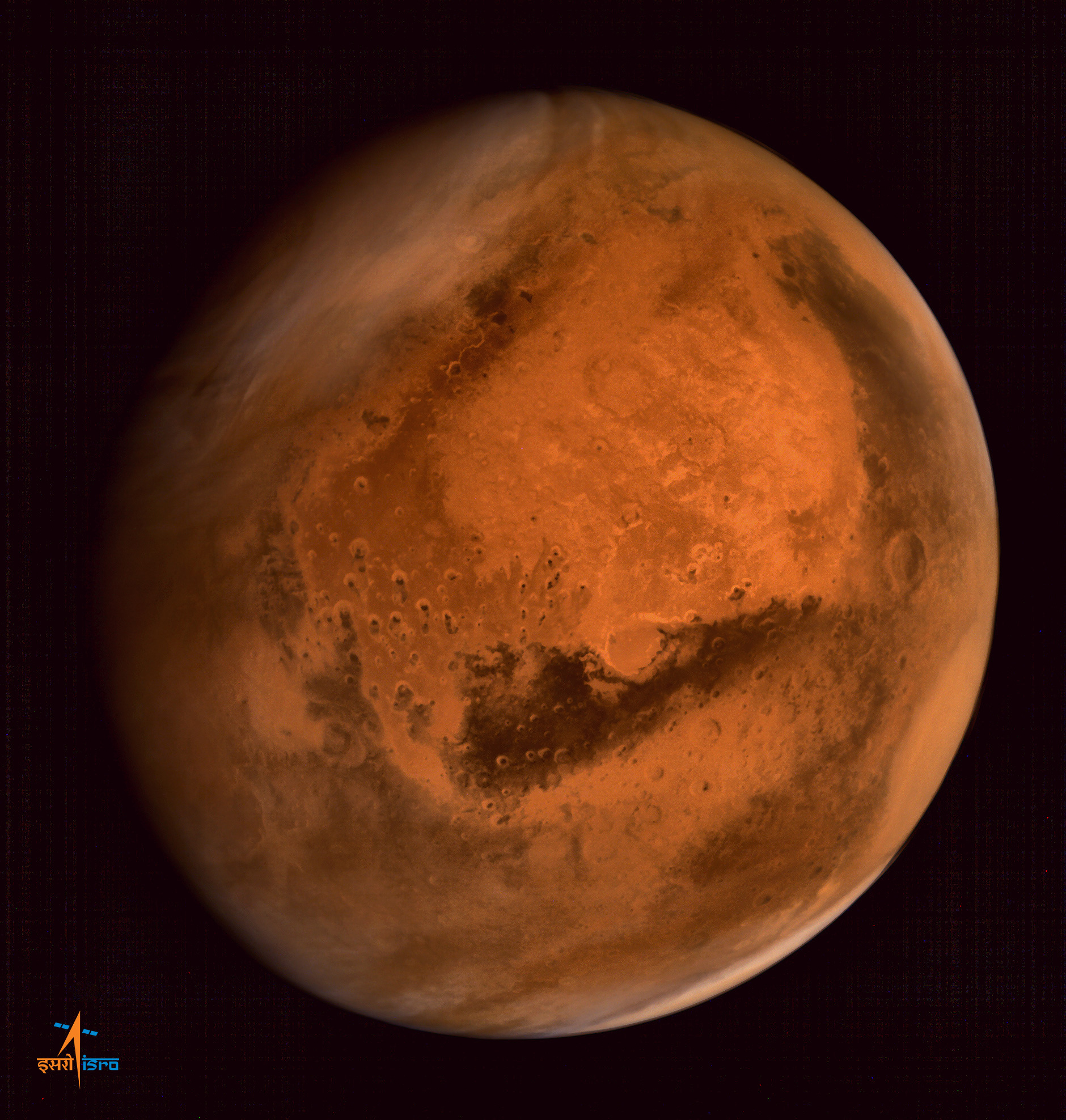
ISRO’s Mars Orbiter Mission captures spectacular portrait of the Red Planet and swirling dust storms with the on-board Mars Color Camera from an altitude of 74,500 km on Sept. 28, 2014. Credit: ISRO
It is no secret that NASA is seeking out private space contractors to help bring some of its current plans to fruition. Naturally, these involve restoring indigenous launch capabilities to the US, but also include the more far-reaching goal of sending astronauts to Mars. Towards that end, NASA and SpaceX participated in an unprecedented data-sharing project that will benefit them both.
Near-infrared image of the Moon's surface by NASA's Moon Mineralogy Mapper on the Indian Space Research Organization's Chandrayaan-1 mission
Image credit: ISRO/NASA/JPL-Caltech/Brown Univ./USGS
When they first set foot on the Moon, the Apollo 11 astronauts painted a picture of the landscape as a bone-dry desert. So astronomers were naturally surprised when in 2009, three probes showed that a lot of water is locked up in minerals in the soil. There has been some debate as to where the water came from, but now two researchers with the National Museum of Natural History in Paris, France, have determined that most of the water in the soil on the surface of the Moon was formed due to protons in the solar wind colliding with oxygen in lunar dust, rather than from comet or meteorite impacts.
The first hints that there was water on the Moon came when India’s Chandrayaan-1 found hints of water across the lunar surface when it measured a dip in reflected sunlight at a wavelength absorbed only by water and hydroxyl, a molecule that contains one atom of hydrogen and one atom of oxygen.
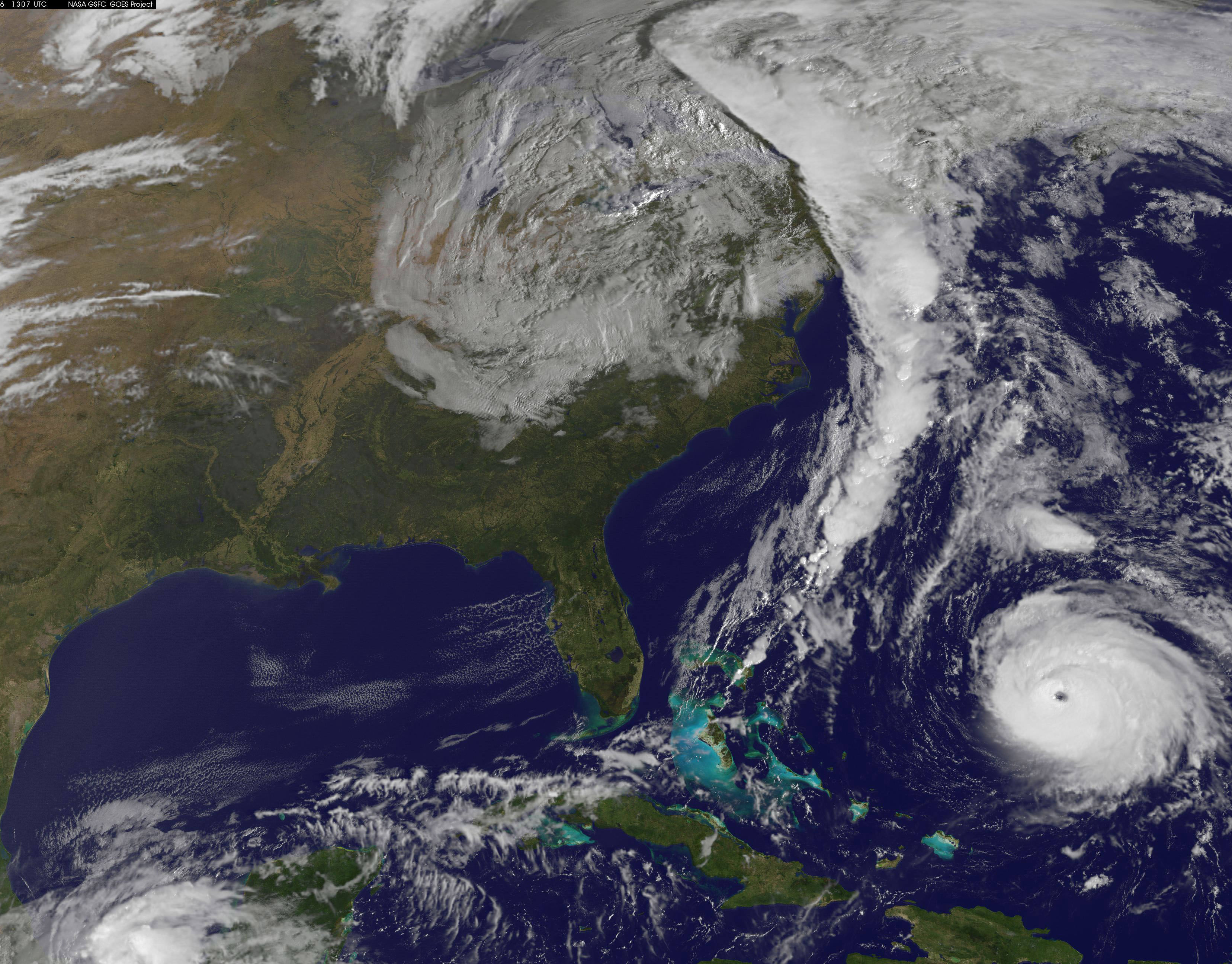
NOAA's GOES-East satellite captured this image of Hurricane Gonzalo off the U.S. East Coast on Oct. 16 at 13:07 UTC (9:07 a.m. EDT). Gonzalo is classified as Category 4 storm. Credit: NASA/NOAA GOES Project
Hurricane Gonzalo, the first major Atlantic Ocean basin hurricane in three years, has strengthened to a dangerous Category 4 storm, threatening Bermuda and forcing a postponement of the upcoming launch of the Orbital Sciences Antares rocket to the space station from the Virginia shore to no earlier than Oct. 27.
A hurricane warning is in effect for the entire island of Bermuda.
NASA and Orbital Sciences had no choice but to delay the Antares blastoff from Oct. 24 to no earlier than Oct. 27 because Bermuda is home to an “essential tracking site” that must be operational to ensure public safety in case of a launch emergency situation.
Antares had been slated for an early evening liftoff with the Cygnus cargo carrier on the Orb-3 mission to the International Space Station (ISS).
NASA and Orbital issued the following statement:
“Due to the impending arrival of Hurricane Gonzalo on the island of Bermuda, where an essential tracking site used to ensure public safety during Antares launches is located, the previously announced “no earlier than” (NET) launch date of October 24 for the Orb-3 CRS mission to the International Space Station for NASA is no longer feasible.”
Orbital Sciences Corporation Antares rocket and Cygnus spacecraft prior to blast off on July 13 2014 from Launch Pad 0A at NASA Wallops Flight Facility , VA, on the Orb-2 mission bound for the International Space Station. Credit: Ken Kremer – kenkremer.com
The powerful Gonzalo is currently expected to make a direct hit on Bermuda on Friday afternoon, Oct. 17. It’s packing devastating maximum sustained winds exceeding 145 mph (225 kph).
NASA and NOAA satellites including the Terra, Aqua and GOES-East satellites are providing continuous coverage of Hurricane Gonzalo as it moves toward Bermuda, according to a NASA update today.
The ISS-RapidScat payload tracking ocean winds, that was just attached to the exterior of the ISS, is also designed to help with hurricane monitoring and forecasting.
Tropical storm force winds and 20 to 30 foot wave heights are expected to impact Bermuda throughout Friday and continue through Saturday and into Sunday.
“The National Hurricane Center expects hurricane-force winds, and rainfall totals of 3 to 6 inches in Bermuda. A storm surge with coastal flooding can be expected in Bermuda, with large and destructive waves along the coast. In addition, life-threatening surf and riptide conditions are likely in the Virgin Islands, Puerto Rico, Dominican Republic, Bahamas. Those dangerous conditions are expected along the U.S. East Coast and Bermuda today, Oct. 16,” according to NASA.
On Oct. 15 at 15:30 UTC (11:30 a.m. EDT) NASA’s Terra satellite captured this image of Hurricane Gonzalo in the Atlantic Ocean. Credit: NASA Goddard MODIS Rapid Response Team
After the hurricane passes, a team will be sent to assess the impact of the storm on Bermuda and the tracking station. Further delays are possible if Bermuda’s essential infrastructure systems are damaged, such as power, transportation and communications.
The Antares/Cygnus rocket and cargo ship launch from the Mid-Atlantic Regional Spaceport at NASA’s Wallops Flight Facility along the eastrn shore of Virginia.
Liftoff is currently target for October 27 at 6:44 p.m. (EDT). The rendezvous and berthing of Cygnus with the ISS remains on November 2, with grapple of the spacecraft by the station’s robotic arm at approximately 4:58 a.m. (EST), according to a NASA update.
Stay tuned here for Ken’s continuing Earth and Planetary science and human spaceflight news.
Manned missions to deep space present numerous challenges. In addition to the sheer amount of food, water and air necessary to keep a crew alive for months (or years) at a time, there’s also the question of keeping them busy for the entirety of a long-duration flight. Exercise is certainly an option, but the necessary equipment will take up space and be a drain on power.
In addition, they’ll need room to move around, places to sleep, eat, work, and relax during their down time. Otherwise, they will be at risk of succumbing to feelings of claustrophobia, anxiety, insomnia, and depression – among other things.
On a clear day, astronauts aboard the ISS can see over 1,000 miles from Havana to Washington D.C. Image Credit: Chris Hadfield / NASA
Orbiting 200 miles above the Earth, Retired Astronaut Chris Hadfield could easily photograph the ridges of the Himalayan Mountains, the textures of the Sahara Desert and the shadows cast by the tallest buildings in Manhattan.
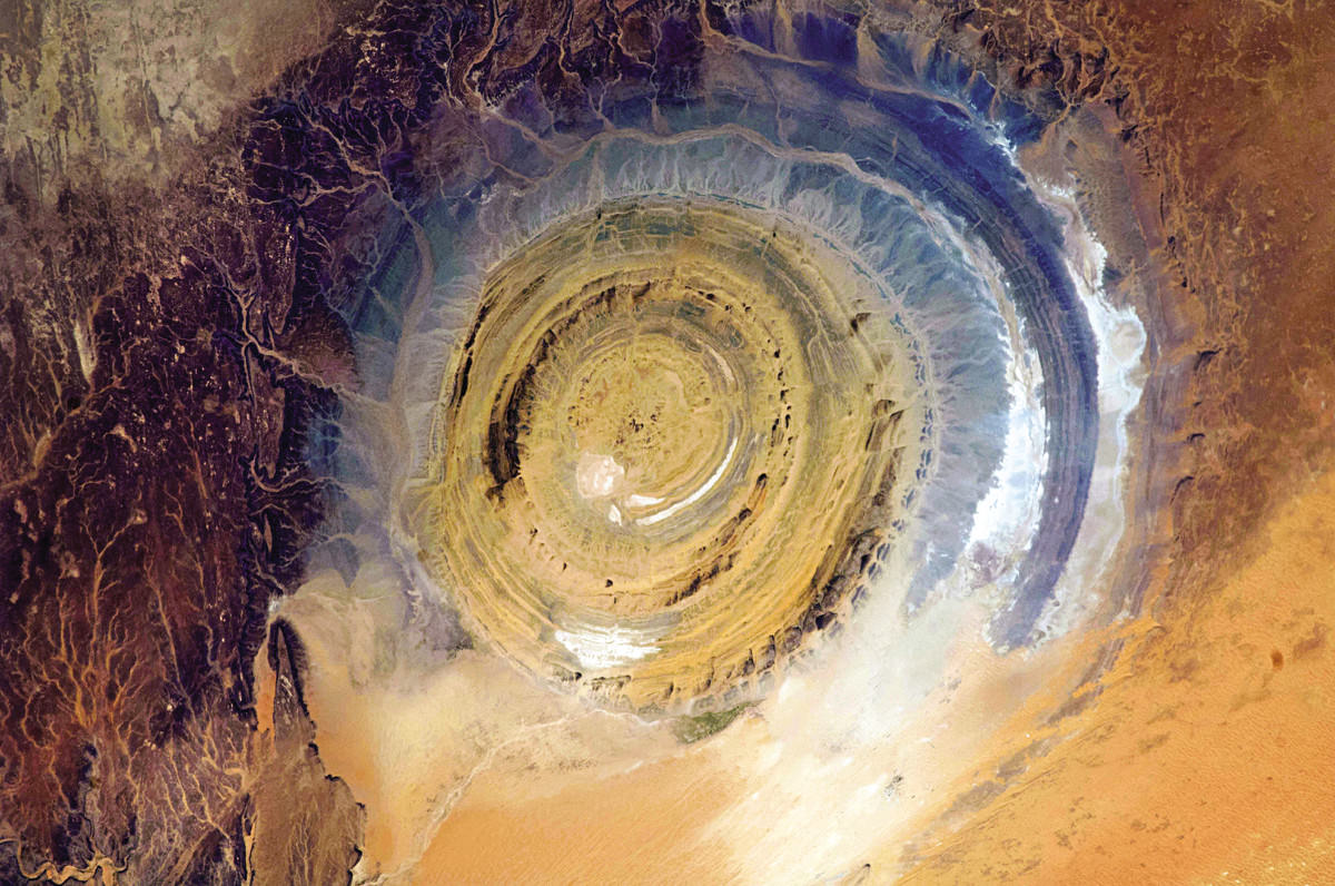
Mauritania, also known as the Eye of the Sahara, is a landmark in the vast 3,600,000-square-mile desert. Credit: Chris Hadfield / NASA
“The view of the world when you have it just right there through the visor of your helmet is overpoweringly gorgeous,” said Hadfield, speaking Oct. 14 at the American Museum of Natural History in New York City. “It is phenomenal. The world is pouring by with all its colors and textures so fast.”
Although Hadfield has already shared many of his photos via social media, he unveiled another 150 images in his latest book, “You Are Here: Around The World in 92 Minutes.” The photographs open a rare window onto the Earth, illuminating our planet’s beauty and the consequences of human settlement.
The book is designed to replicate a single 92-minute orbit aboard the International Space Station. “It’s as if you and I are sitting at the window of the space station, and I said, ‘let’s go around the world once. I want to show you the really cool stuff,’ ” said Hadfield.
The astronaut, famed for his zero-gravity rendition of David Bowie’s “Space Oddity,” took approximately 45,000 photos during his 146-day stint on the space station in 2013. That’s roughly 300 photos per day every day. Since NASA does not set aside specific time slots for astronauts to take photos, Hadfield did so while he should have been asleep or serenading millions with his guitar.
The Himalayan mountain range in South Asia. Credit: Chris Hadfield / NASA
Why? Beauty triggers an unexplained emotional reaction, explained Hadfield. It also provides the best means of communication. Although the space station is an incredible scientific laboratory, art is equally important, he added, because it’s a way to reach people who might not otherwise be interested in the scientific nitty-gritty.
Hadfield is often attributed for humanizing space travel in a way that others before him had not. His use of social media, videos designed to quench our curiosity about living in space, and music, demonstrate a sheer passion that has inspired millions.
Manhattan awake at 9:23 a.m. local time, and Manhattan at rest at 3:45 a.m. local time. Credit: Chris Hadfield / NASA
His photos not only share the natural beauty of our home planet, but also many signs of humanity, from bright city lights to the devastations of climate change as lakes dry up and disappear. “There’s so much information in just one glimpse out the window of human decision making and geology,” said Hadfield.
Hadfield’s remote yet vivid photos stand as a reminder of both the magnificence and fragility of life on our planet. “To have the world on one side, like this huge kaleidoscope, and then the bottomlessness of the Universe right there beside you,” said Hadfield, trailing off in awe. “You’re not on the world looking at it. You’re in the Universe with the world.”
ISS-RapidScat instrument, shown in this artist's rendering, was launched to the International Space Station aboard the SpaceX CRS-4 mission on Sept. 21, 2014 and attached at ESA’s Columbus module. It will measure ocean surface wind speed and direction and help improve weather forecasts, including hurricane monitoring. Credit: NASA/JPL-Caltech/Johnson Space Center.
NASA inaugurated a new era of research for the International Space Station (ISS) as an Earth observation platform following the successful installation and activation of the ISS-RapidScat science instrument on the outposts exterior at Europe’s Columbus module.
The ISS Rapid Scatterometer, or ISS-RapidScat, is NASA’s first research payload aimed at conducting near global Earth science from the station’s exterior and will be augmented with others in coming years.
RapidScat is designed to monitor ocean winds for climate research, weather predictions, and hurricane monitoring.
The 1280 pound (580 kilogram) experimental instrument is already collecting its first science data following its recent power-on and activation at the station.
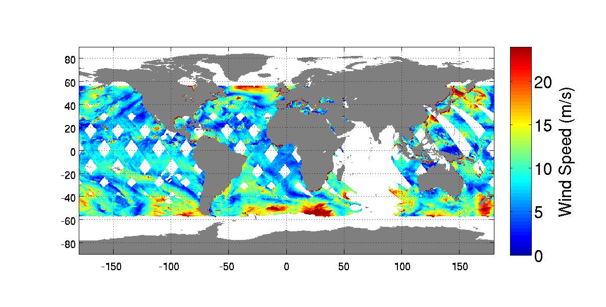
“Its antenna began spinning and it started transmitting and receiving its first winds data on Oct.1,” according to a NASA statement.
The first image from RapidScat was released by NASA on Oct. 6, shown below, and depicts preliminary measurements of global ocean near-surface wind speeds and directions.
Launched Sept. 21, 2014, to the International Space Station, NASA’s newest Earth-observing mission, the International Space Station-RapidScat scatterometer to measure global ocean near-surface wind speeds and directions, has returned its first preliminary images. Credit: NASA-JPL/Caltech
The $26 million remote sensing instrument uses radar pulses to observe the speed and direction of winds over the ocean for the improvement of weather forecasting.
“Most satellite missions require weeks or even months to produce data of the quality that we seem to be getting from the first few days of RapidScat,” said RapidScat Project Scientist Ernesto Rodriguez of NASA’s Jet Propulsion Laboratory, Pasadena, California, which built and manages the mission.
“We have been very lucky that within the first days of operations we have already been able to observe a developing tropical cyclone.
“The quality of these data reflect the level of testing and preparation that the team has put in prior to launch,” Rodriguez said in a NASA statement. “It also reflects the quality of the spare QuikScat hardware from which RapidScat was partially assembled.”
RapidScat, payload was hauled up to the station as part of the science cargo launched aboard the commercial SpaceX Dragon CRS-4 cargo resupply mission that thundered to space on the company’s Falcon 9 rocket from Space Launch Complex-40 at Cape Canaveral Air Force Station in Florida on Sept. 21.
Dragon was successfully berthed at the Earth-facing port on the station’s Harmony module on Sept 23, as detailed here.
It was robotically assembled and attached to the exterior of the station’s Columbus module using the station’s robotic arm and DEXTRE manipulator over a two day period on Sept 29 and 30.
Ground controllers at Johnson Space Center intricately maneuvered DEXTRE to pluck RapidScat and its nadir adapter from the unpressurized trunk section of the Dragon cargo ship and attached it to a vacant external mounting platform on the Columbus module holding mechanical and electrical connections.
Fascinating: #Canadarm & Dextre installed the #RapidScat Experiment on Columbus! @ISS_Research @NASAJPL @csa_asc. Credit: ESA/NASA/Alexander Gerst
The nadir adapter orients the instrument to point at Earth.
The couch sized instrument and adapter together measure about 49 x 46 x 83 inches (124 x 117 x 211 centimeters).
Engineers are in the midst of a two week check out process that is proceeding normally so far. Another two weeks of calibration work will follow.
Thereafter RapidScat will begin a mission expected to last at least two years, said Steve Volz, associate director for flight programs in the Earth Science Division, NASA Headquarters, Washington, at a prelaunch media briefing at the Kennedy Space Center.
RapidScat is the forerunner of at least five more Earth science observing instruments that will be added to the station by the end of the decade, Volz explained.
The second Earth science instrument, dubbed CATS, could be added by year’s end.
The Cloud-Aerosol Transport System (CATS) is a laser instrument that will measure clouds and the location and distribution of pollution, dust, smoke, and other particulates in the atmosphere.
CATS is slated to launch on the next SpaceX resupply mission, CRS-5, currently targeted to launch from Cape Canaveral, FL, on Dec. 9.
A SpaceX Falcon 9 rocket carrying a Dragon cargo capsule packed with science experiments and station supplies blasts off from Space Launch Complex 40 at Cape Canaveral Air Force Station, Florida, at 1:52 a.m. EDT on Sept. 21, 2014, bound for the ISS. Credit: Ken Kremer/kenkremer.com
This has been a banner year for NASA’s Earth science missions. At least five missions will be launched to space within a 12 month period, the most new Earth-observing mission launches in one year in more than a decade.
ISS-RapidScat is the third of five NASA Earth science missions scheduled to launch over a year.
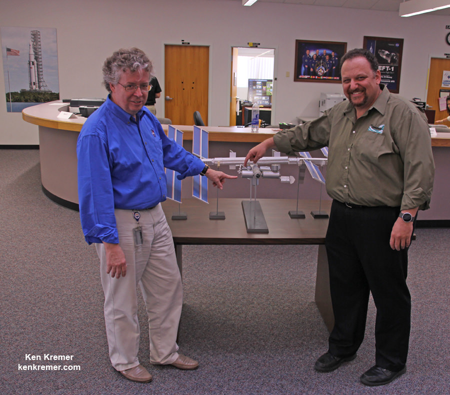
NASA managers show installed location of ISS-RapidScat instrument on the ESA Columbus module on an ISS scale model at the Kennedy Space Center press site during launch period for the SpaceX CRS-4 Dragon cargo mission. Posing are Steve Volz, associate director for flight programs in the Earth Science Division, NASA Headquarters, Washington, and Howard Eisen, RapidScat Project Manager. Credit: Ken Kremer – kenkremer.com
Stay tuned here for Ken’s continuing Earth and Planetary science and human spaceflight news.
Learn more about Commercial Space Taxis, Orion and NASA Human and Robotic Spaceflight at Ken’s upcoming presentations:
Oct 14: “What’s the Future of America’s Human Spaceflight Program with Orion and Commercial Astronaut Taxis” & “Antares/Cygnus ISS Rocket Launches from Virginia”; Princeton University, Amateur Astronomers Assoc of Princeton (AAAP), Princeton, NJ, 7:30 PM
Oct 23/24: “Antares/Cygnus ISS Rocket Launch from Virginia”; Rodeway Inn, Chincoteague, VA
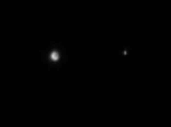
Earth and the Moon imaged by the MESSENGER spacecraft on Oct. 8, 2014
Yes, it’s another time-lapse of the October 8 lunar eclipse that was observed by skywatchers across half the Earth… except that these images weren’t captured from Earth at all; this was the view from Mercury!
The animation above was constructed from 31 images taken two minutes apart by the MESSENGER spacecraft between 5:18 a.m. and 6:18 a.m. EDT on Oct. 8, 2014.
“From Mercury, the Earth and Moon normally appear as if they were two very bright stars,” said Hari Nair, a planetary scientist at the Johns Hopkins University Applied Physics Laboratory, which developed and operates the MESSENGER mission for NASA. “During a lunar eclipse, the Moon seems to disappear during its passage through the Earth’s shadow, as shown in the movie.”
According to Nair the images have been zoomed by a factor of two and the Moon’s brightness has been increased by a factor of about 25 to enhance visibility. Captured by MESSENGER’s narrow-angle camera, Earth and the Moon were 0.713 AU (106.6 million km / 66.2 million miles) away from Mercury when the images were acquired.
Want to see some great photos of the eclipse shared by talented photographers around the world? Click here.
The Oct. 8 “Hunter’s Moon” eclipse was the second and last total lunar eclipse of 2014. The next will occur on April 4 of next year… but by that time MESSENGER won’t be around to witness it.
Launched August 3, 2004, MESSENGER entered orbit at Mercury on March 18, 2011. It is currently nearing the end of its missions as well as its its operational life, but we still have several more months of observations to look forward to from around the Solar System’s innermost planet before MESSENGER makes its final pass and ultimately impacts Mercury’s surface in March 2015.
Video credit: NASA/Johns Hopkins University Applied Physics Laboratory/Carnegie Institution of Washington
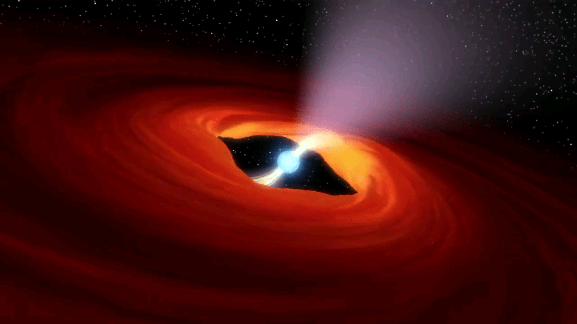
Artist's illustration of a rotating neutron star, the remnants of a super nova explosion. Credit: NASA, Caltech-JPL
A research team led by Caltech astronomers of Pasadena California have discovered an ultraluminous X-ray (ULX) source that is pulsating. Their analysis concluded that the source in a nearby galaxy – M82 – is from a rotating neutron star, a pulsar. This is the first ULX source attributed to a pulsar.
Matteo Bachetti of the Université de Toulouse in France first identified the pulsating source and is the lead author of the paper, “An ultraluminous X-ray source powered by an accreting neutron star” in the journal Nature. Caltech astronomer Dr. Fiona Harrison, the team leader, stated “This compact little stellar remnant is a real powerhouse. We’ve never seen anything quite like it. We all thought an object with that much energy had to be a black hole.”
What is most extraordinary is that this discovery places even more strain on theories already hard pressed to explain the existence of ultraluminous X-Ray sources. The burden falls on the shoulder of the theorists.
The NuStar Space Telescope launched into Earth orbit by a Orbital Science Corp. Pegasus rocket, 2012. The Wolter telescope design images throughout a spectral range from 5 to 80 KeV. (Credit: NASA/Caltech-JPL)
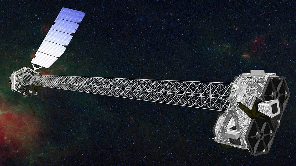
The source of the observations is the NuSTAR space telescope, a SMEX class NASA mission. It is a Wolter telescope that uses grazing incidence optics, not glass (refraction) or mirrors (reflection) as in visible light telescopes. The incidence angle of the X-rays must be very shallow and consequently the optics are extended out on a 10 meter (33 feet) truss. NuSTAR records its observations with a time stamp such as taking a video of the sky. The video recording in high speed is not in visible everyday light but what is called hard x-rays. Only gamma rays are more energetic. X-rays emanate from the most powerful sources and events in the Universe. NuStar observes in the energy range of X-Rays from 5 to 80 KeV (electron volt)while the famous Chandra space telescope observes in the .1 to 10 KeV range. Chandra is one NASA’s great space telescope, was launched by the Space Shuttle Columbia (STS-93) in 1999. Chandra has altered our view of the Universe as dramatically as the first telescope constructed by Galileo. NuSTAR carries on the study of X-rays to higher energies and with greater acuity.
ULX sources are rare in the Universe but this is the first pulsating ULX. After analysis, they concluded that this is not a black hole but rather its little brother, a spinning neutron star as the source. More specifically, this is an accreting binary pulsar; matter from a companion star is being gravitationally attracted by and accreting onto the pulsar.
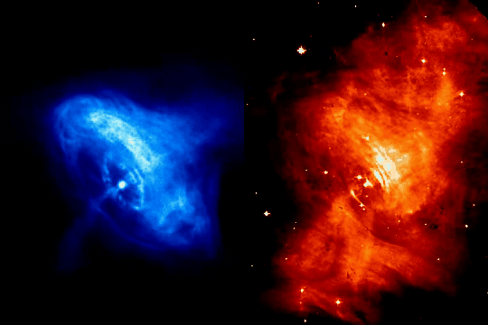
The prime example of a pulsar – the Crab Nebula Pulsar, M1. These actual observations show the expansion of shock waves emanating from the Pulsar interacting with the surrounding nebula. The Crab Pulsar actually pulsates 30 times per second, not seen here, a result of its rotation rate and the relative offset of the magnetic pole. Charndra X-Rays (left), Hubble Visible light (right). (Credit: NASA, JPL-Caltech)
Take a neutron star and spin it up to anywhere from 700 rotations per second to a mere one rotation every 10 seconds. Now you have a neutron star called a pulsar. Spinning or not, these are the remnants of supernovae, stellar explosions that can outshine a galaxy of 300 billion stars. Just one teaspoon of neutron star material weighs 10 million tons (9,071,847,400 kg). That is the same weight as 900 Great Pyramids of Giza all condensed to one teaspoon. As incredible a material and star that a neutron star is, they were not thought to be the source of any ultraluminous X-Ray sources. This view has changed with the analysis of observations by this research team utilizing NuSTAR. The telescope name – NuSTAR – stands for Nuclear Spectroscopic Telescope Array.
There is nothing run of the mill about black holes. Dr. Stephen Hawking only conceded after 25 years, in 2004 (the Thorne-Hawking Bet) that Black Holes exist. And still today it is not absolutely certain. Recall the Universe Today weekly – Space Hangout on September 26 – “Do Black Holes exist?” and the article by Jason Major, “There are no such things as Black Holes.”
Pulsars stars are nearly as exotic as black holes, and all astronomers accept the existence of these spinning neutron stars. There are three final states of a dying star. Stars like our Sun at the end of their life become very dense White Dwarf stars, about the size of the Earth. Neutron stars are the next “degenerate” state of a dying exhausted star. All the electrons have merged with the protons in the material of the star to become neutrons. A neutron star is a degenerate form of matter effectively made up of all neutron particles. Very dense, these stars are really small, the size of cities, about 16 miles in diameter. The third type of star in its final state is the Black Hole.
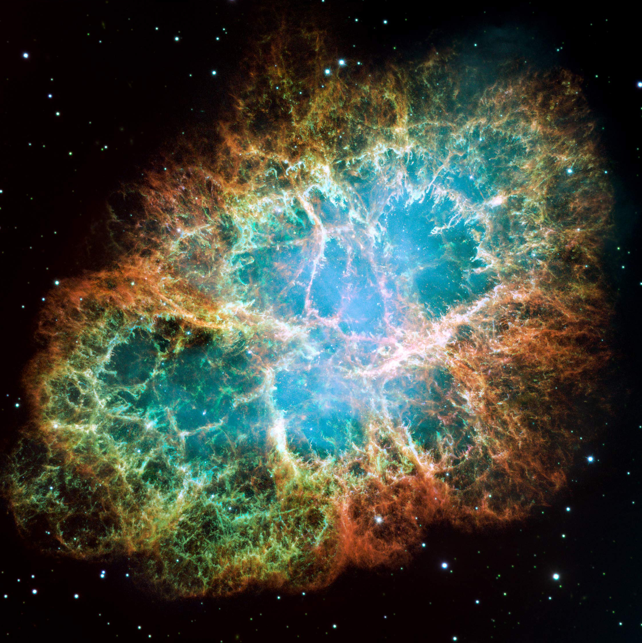
The Crab Nebula was first observed in the 1700s and is catalogued Messier object, M1. The remant explosion of a SuperNova that Chinese astronomers observed in 1054 A.D, it holds the second Pulsar discovered (1968).
A spinning neutron star creates a magnetic field, the most powerful of such fields in the Universe. They are like a dipole of a bar magnet and because of how magnetic fields confine the hot gases – plasma – of the neutron star, constant streams of material flow down and light streams out from the magnetic poles.
Recently, the Earth has had incredible northern lights, aurora. These lights are also from hot gases — a plasma — at the top of our atmosphere. Likewise, hot energetic particles from the Sun are funneled down into the magnetic poles of the Earth’s field that creates the northern lights. For spinning neutron stars – pulsars – the extreme light from the magnetic poles are like beacons. Just like our Earth, the magnetic poles and the spin axis poles do not coincide. So the intense beacon of light will rotate around and periodically point at the Earth. The video of the first illustration describes this action.
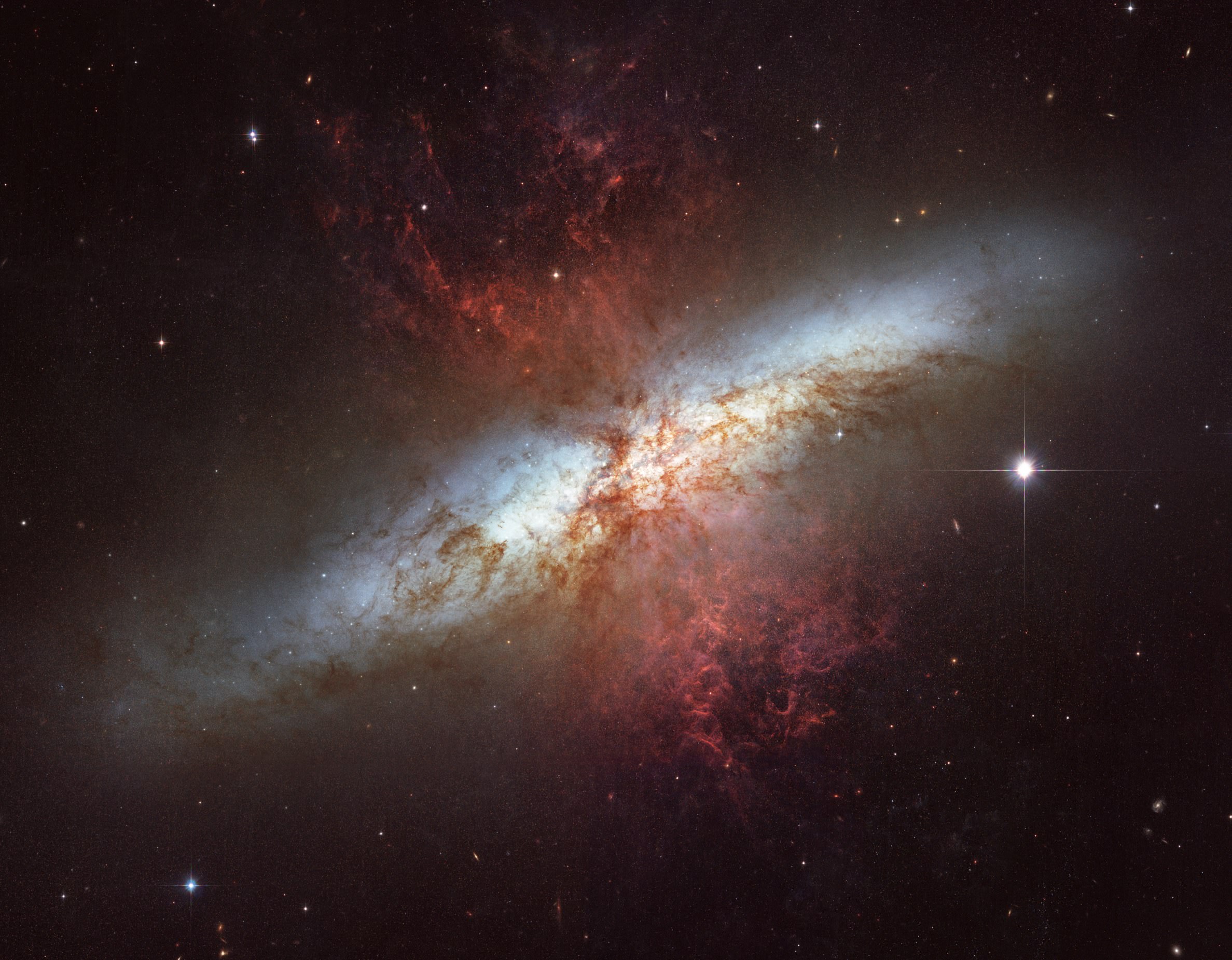
Messier object – M82, the Cigar Nebula, nicknamed for the shape seen through telescopes of the 1800s. This is the location of the newly discovered Pulsar.
The light beacons from pulsars are very bright but theory, until now, has been supported by observations. No ultraluminous X-ray sources should be pulsars. The newly discovered pulsar is outputting 100 times more energy than any other. Discoveries like the one by these astronomers utilizing NuSTAR is proof that there remains more to discover and understand and new telescopes will be conceived to help resolve questions raised by NuSTAR or Chandra.